Overview
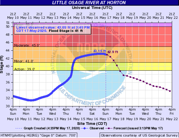
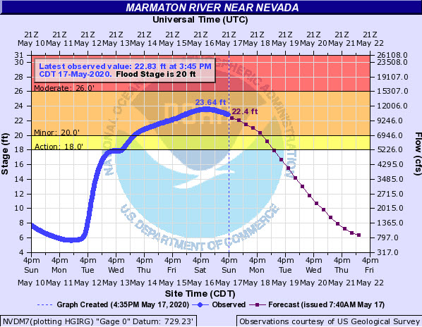
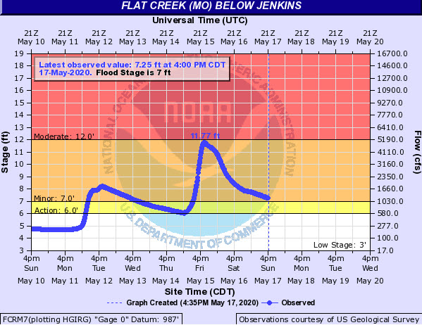
A moist and unstable air mass remained in place over the weekend of May 16th-17th, 2020. With a very slow moving upper level low pressure system bringing waves of energy into the area from the south and near tropical moisture in place, this set the stage for additional heavy rain. The work week leading up to the weekend of the 16th and 17th was also fairly rainy which led to fairly saturated soil moisture levels. Showers and thunderstorms were slow moving and trained across the same locations during the early morning hours of the 16th, with more scattered thunderstorms continuing throughout the day. A second wave of more organized showers and storms lifted north out of Arkansas during the late evening of the 16th, continuing into the morning of the 17th. This led to some widespread flooding and flash flooding, especially in low lying areas near rivers, creeks and streams as many of these had gone well above flood stage.Flooding
Hydrographs
 |
 |
 |
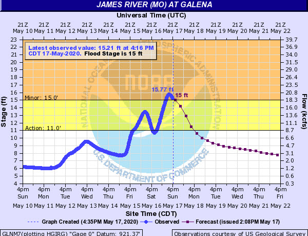 |
| Little Osage River - Horton | Marmaton River - Nevada | Flat Creek - Jenkins | James River - Galena |
 |
 |
 |
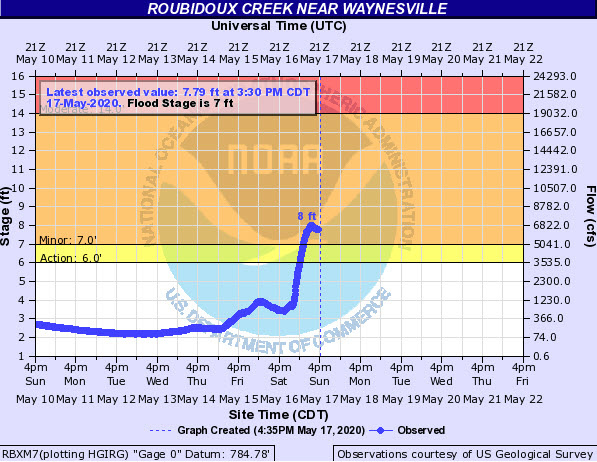 |
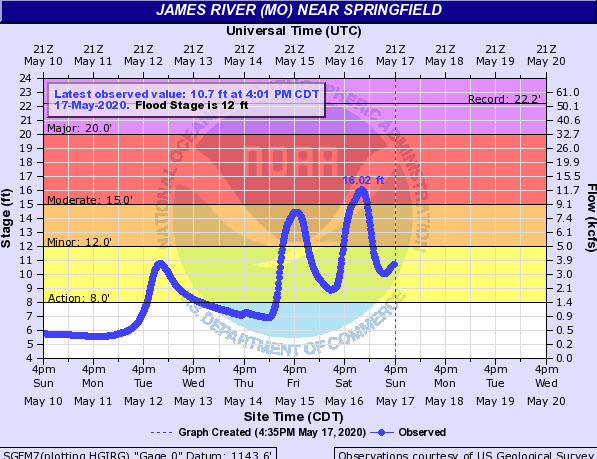
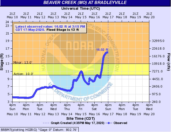
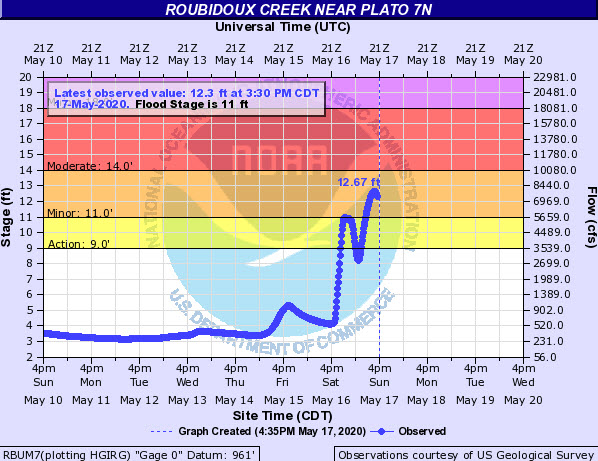
| James River - Springfield | Beaver Creek - Bradleyville | Roubidoux Creek - near Plato 7N | Roubidoux Creek - Waynesville |
 |
 |
 |
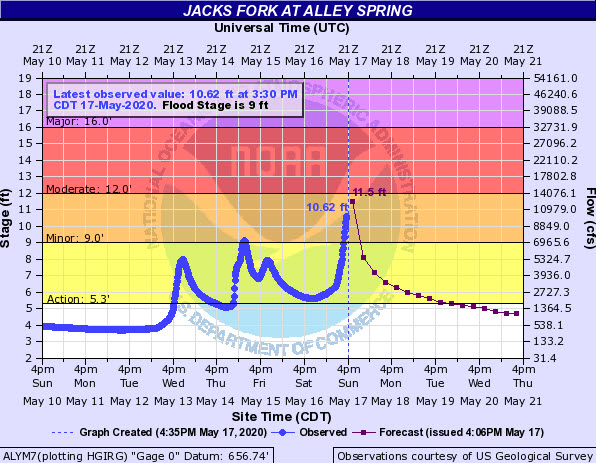 |
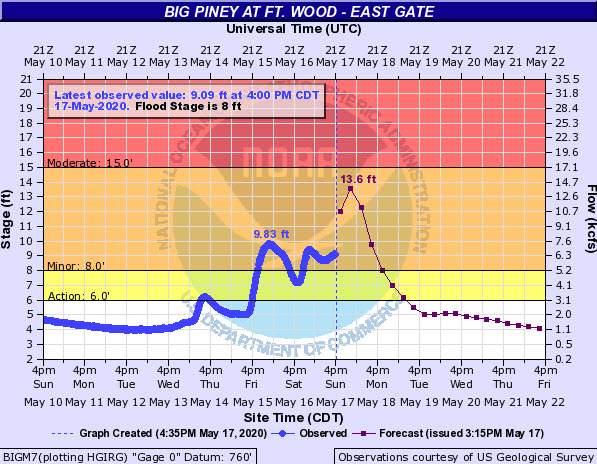
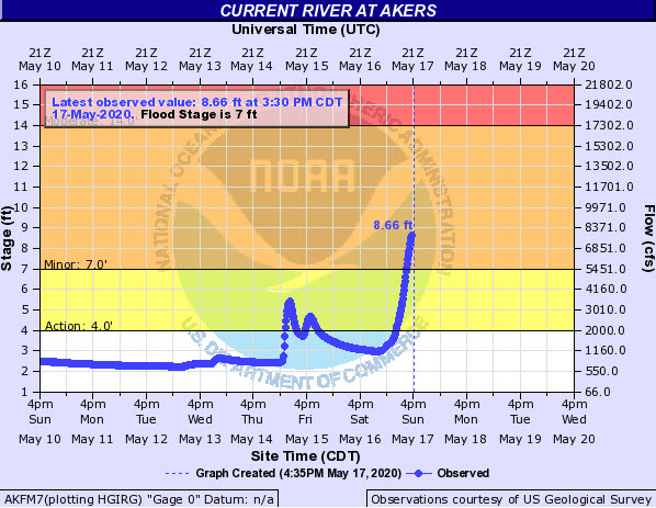
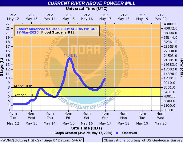
| Big Piney River - Fort Leonard Wood | Current River - Akers | Current River - Powder Mill | Jacks Fork - Alley Spring |
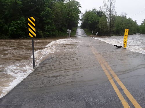
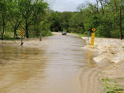
Photos
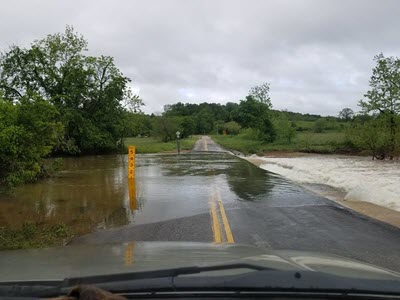 |
 |
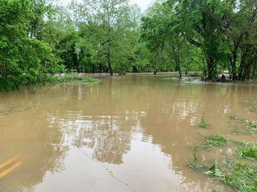 |
 |
| Gainesville Flooding | Flooding near Brownbranch | Flooding - Hunter Creek | Mansfield - Flooding |
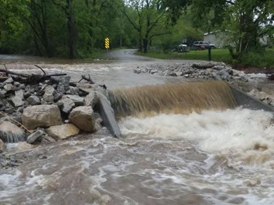
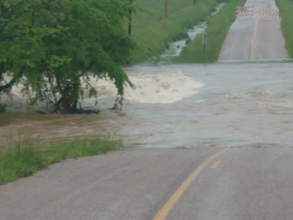
 |
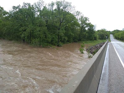 |
 |
|
| Flooding - Bradleyville | Beaver Bridge - Bradleyville | Marshfield Flooding |
Rain Reports
Public Information Statement
National Weather Service Springfield MO
925 AM CDT Sun May 17 2020

...72 HOUR PRECIPITATION REPORTS...

Location                     Amount    Time/Date       Provider
Summersville 3.6 S           6.89 in   0700 AM 05/17   COCORAHS
Ava/Reuter RAWS              5.42 in   0853 AM 05/17   RAWS
Mansfield 3.7 SSE            4.91 in   0700 AM 05/17   COCORAHS
Mountain View 7.0 NE         4.58 in   0700 AM 05/17   COCORAHS
Fort Leonard Wood 5.4 SE     3.92 in   0800 AM 05/17   COCORAHS
Ava 6nw                      3.88 in   0701 AM 05/17   COOP
Mountain View RAWS           3.50 in   0745 AM 05/17   RAWS
5 N Wasola                   3.43 in   0700 AM 05/17   COOP
Mountain Grove               3.22 in   0915 AM 05/17   MOCOMAGNET
Roby RAWS                    3.22 in   0839 AM 05/17   RAWS
West Plains 1.0 W            3.11 in   0800 AM 05/17   COCORAHS
West Plains COOP             3.11 in   0800 AM 05/17   COOP
Emerald Beach 5.5 E          3.01 in   0700 AM 05/17   COCORAHS
Mountain Grove RAWS          2.85 in   0745 AM 05/17   RAWS
Branson 3.2 NNW              2.85 in   0824 AM 05/17   COCORAHS
Houston 4.5 ESE              2.82 in   0700 AM 05/17   COCORAHS
Sinkin RAWS                  2.80 in   0810 AM 05/17   RAWS
Newburg 9.6 SSW              2.77 in   0708 AM 05/17   COCORAHS
West Plains ASOS             2.75 in   0853 AM 05/17   ASOS
Springfield 4.9 SE           2.75 in   0700 AM 05/17   COCORAHS
Salem 1.8 NW                 2.71 in   0435 AM 05/17   COCORAHS
Marshfield 3.6 S             2.69 in   0600 AM 05/17   COCORAHS
Willard 5.8 NNE              2.63 in   0800 AM 05/17   COCORAHS
Houston 5.0 SE               2.62 in   0700 AM 05/17   COCORAHS
Marshfield 4 WSW             2.62 in   0700 AM 05/17   COOP
Shell Knob 5.6 ESE           2.49 in   0800 AM 05/17   COCORAHS
Cassville RAWS               2.40 in   0747 AM 05/17   RAWS
2 WSW Rolla                  2.31 in   0800 AM 05/17   HADS
1 NE Tecumseh                2.29 in   0700 AM 05/17   COOP
10 w Salem                   2.26 in   0500 AM 05/17   HADS
Salem 14.9 E                 2.25 in   0700 AM 05/17   COCORAHS
Purdy 4.8 SSW                2.23 in   0700 AM 05/17   COCORAHS
Rolla 8.2 SSE                2.22 in   0615 AM 05/17   COCORAHS
Salem 1.1 NNE                2.21 in   0700 AM 05/17   COCORAHS
3 NNE Laquey                 2.21 in   0600 AM 05/17   COCORAHS
Noel 3.8 NNE                 2.20 in   0700 AM 05/17   COCORAHS
Cassville 4.8 SSE            2.19 in   0700 AM 05/17   COCORAHS
Rolla 7.6 SSE                2.19 in   0700 AM 05/17   COCORAHS
Salem 3.5 E                  2.16 in   0800 AM 05/17   COCORAHS
Hollister 3.8 SW             2.15 in   0700 AM 05/17   COCORAHS
Springfield 4.4 SSE          2.14 in   0740 AM 05/17   COCORAHS
Winona 2.8 SW                2.13 in   0800 AM 05/17   COCORAHS
Winona 3 SW COOP             2.13 in   0700 AM 05/17   COOP
Ava                          2.11 in   0800 AM 05/17   HADS
Lebanon 0.6 N                2.11 in   0739 AM 05/17   COCORAHS
Battlefield 3.3 E            2.10 in   0700 AM 05/17   COCORAHS
Marshfield 0.9 SE            2.08 in   0730 AM 05/17   COCORAHS
Fair Grove 4.7 SSW           2.05 in   0700 AM 05/17   COCORAHS
Carr Creek RAWS              2.04 in   0835 AM 05/17   RAWS
Rolla 8.1 SSE                2.03 in   0700 AM 05/17   COCORAHS
 |
Media use of NWS Web News Stories is encouraged! Please acknowledge the NWS as the source of any news information accessed from this site. |
|


 Weather Story
 Weather Map
 Local Radar