
Dangerous heat will expand from the Gulf Coast into the Southern Plains and Desert Southwest through week's end. Additional extreme heat impacting the Pacific Northwest will shift to the northern Plains by the weekend. Tropical Storm Bertha is expected to continue to impact portions of the northern Gulf Coast from the western Florida Panhandle to southeastern Louisiana through tonight. Read More >

Synopsis:
Synopsis for portions of western and central Montana:
Synopsis for the state of Montana:
Current Hazards- Click On Left Menu For More Options
Snowfall - See Winter Probability Site Here
 |
| NWS Snow Event Forecast Click to Enlarge |
 |
 |
 |
|
Percent Chance of Measurable Snowfall |
Percent Chance of Snowfall Greater Than 2 inches |
Percent Chance of Snowfall Greater Than 6 Inches |
Precipitation (Liquid)
 |
| WPC 7-Day Liquid QPF Forecast Click to Enlarge |
 |
 |
 |
| Day 1 Liquid QPF Forecast Click to Enlarge |
Day 2 Liquid QPF Forecast Click to Enlarge |
Day 3 Liquid QPF Forecast Click to Enlarge |
Temperatures
 |
 |
 |
| Day 1 Forecast High Temperatures Click to Enlarge |
Day 2 Forecast High Temperatures Click to Enlarge |
Day 3 Forecast High Temperatures Click to Enlarge |
 |
 |
 |
| Tonight Forecast Low Temperatures Click to Enlarge |
Tomorrow Night Forecast Low Temperatures |
Night 3 Low Temperatures Forecast |
Wind Chill Forecast
 |
| 2 Day Wind Chill Forecast Click to Enlarge |
Wind Gusts
 |
| Maximum Wind Gust Forecast Click to Enlarge |
Ice Forecast - Central MT Only
 |
| NWS Snow Event Forecast Click to Enlarge |
Long Range Forecast
Day 4-7 Precipitation (Liquid)
|
| WPC 7-Day Liquid QPF Forecast Click to Enlarge |
 |
 |
 |
| Day 4 Liquid QPF Forecast Click to Enlarge |
Day 5 Liquid QPF Forecast Click to Enlarge |
Day 6 Liquid QPF Forecast Click to Enlarge |
Day 4-7 Temperatures
 |
|
| Day 4 Forecast High Temperatures Click to Enlarge |
Day 5 Forecast High Temperatures Click to Enlarge |
 |
 |
| Day 4 Forecast Low Temperatures Click to Enlarge |
Day 5 Forecast Low Temperatures |
Extended Range Forecast
 |
 |
|
Climate Prediction Center (CPC) 6-10 Day Temperature Outlook Click to Enlarge |
Climate Prediction Center (CPC) 6-10 Day Precipitation Outlook Click to Enlarge |
 |
 |
|
Climate Prediction Center (CPC) 8-14 Day Temperature Outlook Click to Enlarge |
Climate Prediction Center (CPC) 8-14 Day Precipitation Outlook Click to Enlarge |
*Note: Images are based on latest published forecast. Refresh browser for the most up to date forecast details.
 |
| The current Road Conditions from MTDOT. Click on the image or here for an interactive road conditions map. You can also dial 5-1-1 on your phone. Want a mobile app version of this information? Click here. |
 |
| Click on the image for an interactive road forecast travel map. Note...this site is currently a prototype and under development - not to be relied upon for operational decision making. |
 |
 |
 |
 |
|
Missoula Radar Loop Click to Enlarge |
Great Falls Radar Loop Click to Enlarge |
Billings Radar Loop Click to Enlarge |
Glasgow Radar Loop Click to Enlarge |
 |
 |
 |
 |
|
Regional Radar Loop Click to Enlarge |
Visible Satellite |
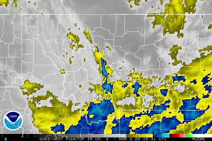
Infrared Satellite Click to Enlarge |
Water Vapor Satellite Click to Enlarge |


 Great Falls Radar
 Satellite
 Current Observations
 Forecast Discussion
 Montana Weather
 Fire Weather
 Winter Weather Forecasts
 Transportation Forecasts
 Weather Prediction Center
 Storm Prediction Center
 Aviation Weather
 Weather Stats