
Dangerous and extreme heat will remain across portions of the southern U.S. this week. Heavy rainfall may bring significant flash flooding across portions of the Mid-Atlantic and Northeast through the night, and additional flash flooding concerns across New England on Wednesday. Monsoonal thunderstorms will bring a flash flood risk to the Four Corners region, especially in burn scar areas Read More >
|
Severe thunderstorms rolled through central and northeast Kansas beginning in the afternoon of Thursday, April 18th, then finally exiting northeast Kansas in the morning of Friday, April 19th. The initial focusing mechanism for the thunderstorms was a dry line in central Kansas, that separated a very moist and unstable air mass to the east, and much drier air to the west. A cold front also came into play during the overnight hours, racing southeast through northeast Kansas by sunrise. Thunderstorms began firing along the dry line Thursday afternoon, affecting central and northeast Kansas. The National Weather Service in Topeka issued it's first Severe Thunderstorm Warning of the event at 536 PM for northern and central Dickinson county. Many more warnings followed during the evening and early morning, with the last Severe Thunderstorm Warning expiring at 530 AM for Jefferson and Douglas counties. In all, 29 county warnings were issued, 26 Severe Thunderstorm Warnings, and 3 Tornado Warnings. 25 of the 29 county warnings were verified with a report of severe weather. In all, 45 reports of severe weather were received by the Topeka office, all of which occurred within counties under warnings. During the evening on Thursday, most of the severe weather reports were of large hail of about an inch in diameter. The first report was of nickel-size hail 5 miles southeast of Solomon in Dickinson county at 544 PM. The last severe hail report was received at 755 PM one mile west of Hiawatha in Brown county. During that just over 2-hour period, 11 reports of hail were received from Dickinson county, northeast through Geary, Riley, Pottawatomie, Nemaha and Brown counties. A second round of severe thunderstorms started in the early morning hours on Friday the 19th. The first Severe Thunderstorm Warning of Friday morning was issued at 1246 AM for southern Clay county in north central Kansas. Subsequent warnings were issued for Cloud, Ottawa, Riley, Pottawatomie, and Dickinson counties. These thunderstorms produced dime-size to golf ball-size hail in several locations. Between 230 and 300 AM, the thunderstorms formed into a line of storms, and took on more of a bow echo shape as they raced east. While more reports of three-quarter to one inch hail were received, the main severe weather reports were coming in the form of damaging winds. An 82 MPH wind gust was reported in Manhattan at 304 AM, with 60 to 75 MPH wind gusts reported across Riley, Pottawatomie, Wabaunsee, Jackson, Shawnee, Jefferson and Douglas counties through the morning. The last severe thunderstorm wind was received just before 500 AM two miles northwest of Lawrence. Just below are pictures from the Topeka radar showing reflectivity and velocity images as the bow echo marched into Shawnee county. Some damage photos can be found at the bottom of this page. A complete list of severe weather reports can be found here.
|
||
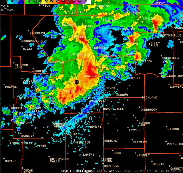 |
This 0853Z (353 AM) shows the bow echo moving through western Wabaunsee county and approaching Shawnee county |
|
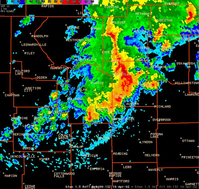 |
This reflectivity image was 20 minutes later at 0913Z (413 AM). The storms were producing damage in north Topeka at this time. |
|
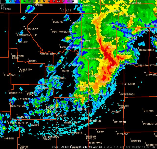 |
This reflectivity image was 10 minutes later at 423 AM. A 59 MPH wind gust was recorded at the National Weather Service Office three minutes later at 426 AM. |
|
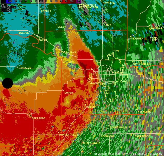 |
This velocity image is from 408 AM. The darkest browns in the image represent winds greater than 65 knots or 75 MPH. |
|
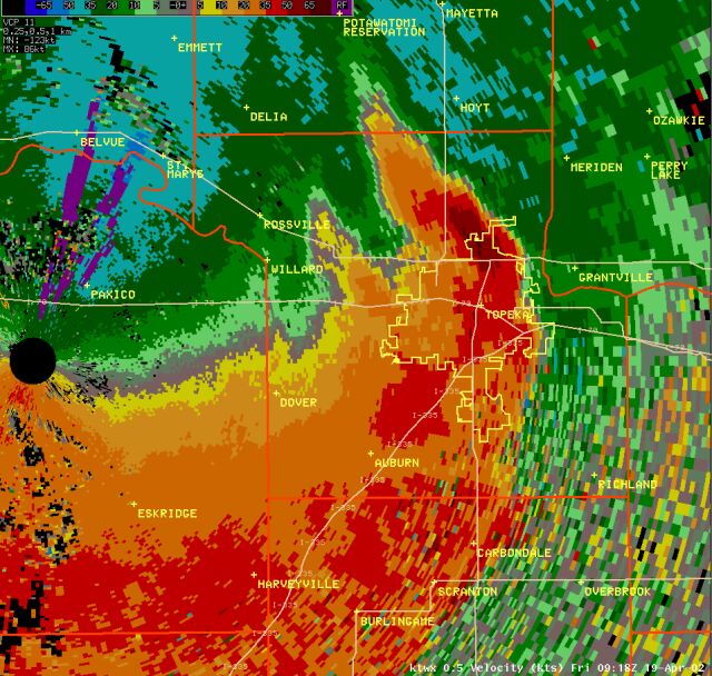 |
10 minutes later, at 418 AM, the core of 75+ mph winds had streaked across most of north Topeka |
|
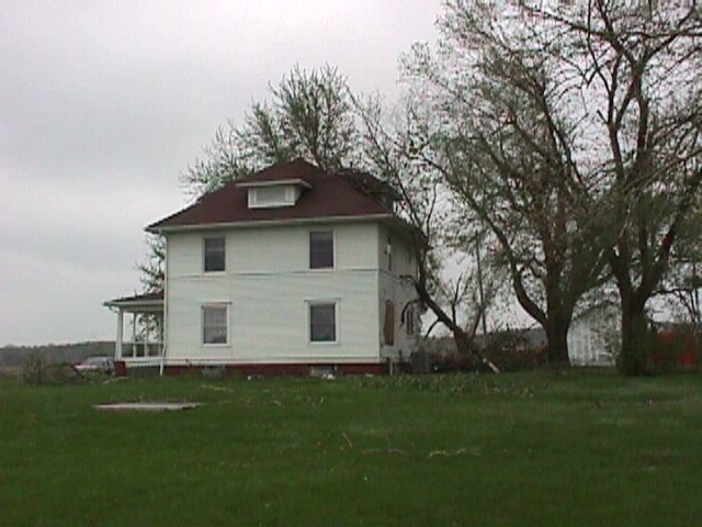
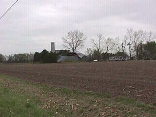
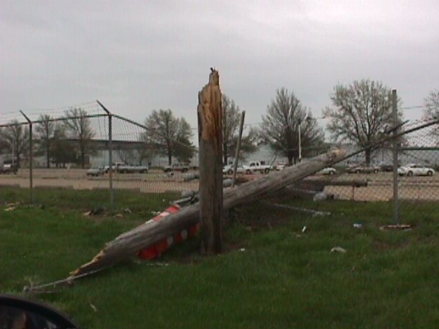
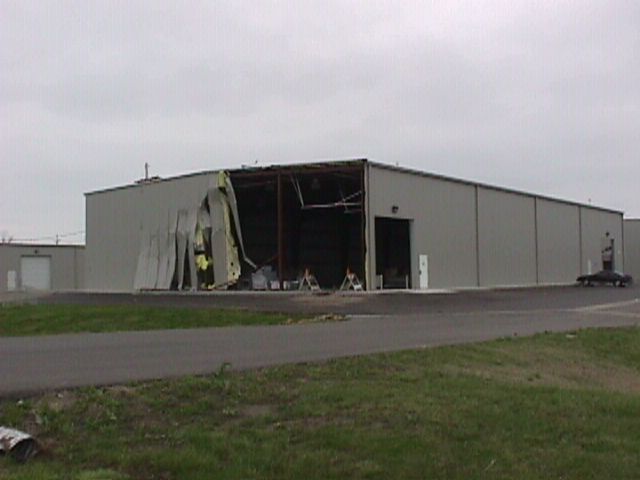
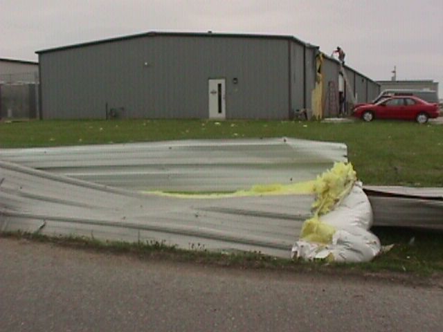
| A storm survey was conducted across northern Shawnee county, including north Topeka, Friday morning. The damage pictures below were taken along Highway 24 and Lower Silver Lake Road, between Huxman and Rochester Roads in northern Shawnee county. Click each picture for a larger view. | ||
 |
 |
 |
 |
 |
 |

