
Dangerous heat will expand from the Gulf Coast into the Southern Plains and Desert Southwest through week's end. Additional extreme heat impacting the Pacific Northwest will shift to the northern Plains by the weekend. Tropical Storm Bertha is expected to continue to impact portions of the northern Gulf Coast from the western Florida Panhandle to southeastern Louisiana through tonight. Read More >
Topeka, KS
Weather Forecast Office
The Winter Storm of January 25th and 26th
A wintry mix of freezing rain, sleet and snow fell across North Central, Northeast and East Central Kansas on January 25th and 26th. The precipitation fell as mainly snow across North Central Kansas with reports of 4 to 6 inches common

Figure 1 Snow depth reports through 7 am 1/27/2004
Freezing rain occurred across much of the area on January 25th. Ice accumulations of 1/4 to 1/2 of an inch were reported (Figure 2) across Northeast and parts of East Central Kansas. The ice built up on trees and power lines and caused numerous power outages and downed limbs across North Central and Northeast Kansas. Slick roads also led to numerous accidents across the area.
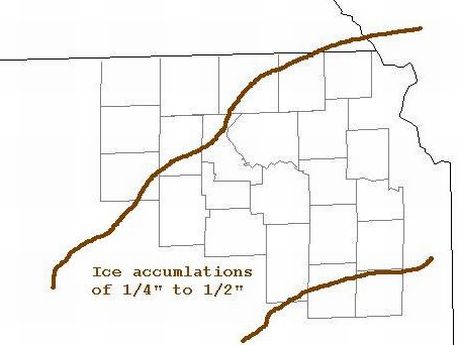
Figure 2 Ice Accumulations reported on 1/27/2004
The freezing rain occurred as a layer of warm air (located about 3000 to 6000 feet above the ground) spread over a layer of below freezing air at the surface (Figure 3). This allowed the precipitation to fall as rain instead of snow. When the rain struck the cold ground, trees and cars, it froze causing the widespread glazing exposed objects.
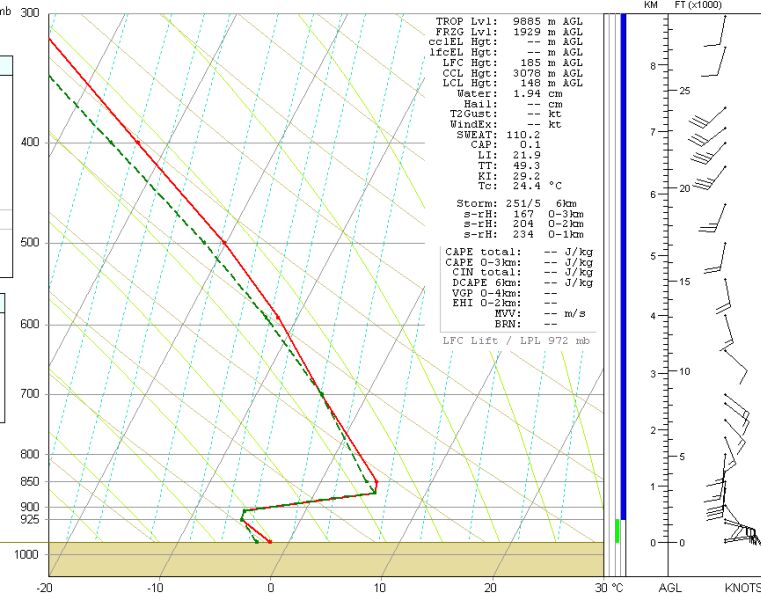
Figure 3 The Topeka sounding from 7 am 1/25/2004
US Dept of Commerce
National Oceanic and Atmospheric Administration
National Weather Service
Topeka, KS
1116 NE Strait Avenue
Topeka, KS 66616-1667
785-234-2592
Comments? Questions? Please Contact Us.

