
Dangerous and extreme heat will remain across portions of the southern U.S. this week. A heat wave over the Southwest U.S. will intensify this week, peaking and expanding into the Intermountain West and northern High Plains this weekend. Multiple rounds of thunderstorms will produce heavy to excessive rainfall with significant flash flooding across portions of southern New England today. Read More >
A strong upper level storm system affected parts of the eastern Central Plains and mid Mississippi Valley on December 7th into December 8th 2005. In the NWS Topeka County Warning Area, parts of east central Kansas received over 8" of snow. Generally, in the Topeka area of forecast responsibility, more than 6" of snow fell southeast of a line from Emporia to Topeka to Valley Falls. Eight inches or more fell across southeast Jefferson, most of Douglas, most of Franklin, southeast Osage, far southeast Lyon, parts of Coffey, and northwest Anderson counties (see snowfall map below). An interesting feature of the storm was that there was about a 20 to 1 snow to liquid water equivalent ratio, i.e. an area receiving 0.30" of liquid water equivalent (melted snow), received about 6" of snow. This snow was much drier than the average that is "typically" received in our part of Kansas, as it fell with temperatures that were hovering around 10 degrees Fahrenheit. Less snow fell in the north central parts of the state, averaging around 2".
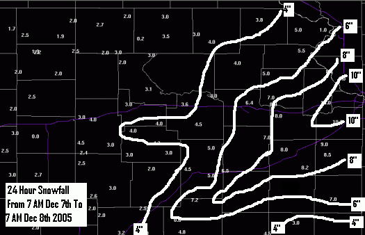
TABLE LISTING SNOWFALL AND SNOW DEPTH IN THE LAST 2 COLUMNS
DEPTH IN THE LAST 2 COLUMNS.
TOP : TOPEKA BILLARD ARPT : 11 / -1 / 0.35 / 6.4 / 4
CNK : CONCORDIA BLOSSER ARPT : 11 / 5 / 0.14 / 2.2 / 2
FOE : TOPEKA FORBES FIELD ARPT : 10 / -6 / 0.17 / /
LWC : LAWRENCE MUNI ARPT : 12 / -5 / 0.23 / /
MHK : MANHATTAN RGNL ARPT : 12 / -11 / 0.08 / /
EMP : EMPORIA MUNI ARPT : 11 / -6 / 0.00 / /
.END
:
.BR TOP 1208 C DH07/TX/TN/PP/SF/SD
:
: COOPERATIVE OBSERVATIONS
: VALUES ARE FOR THE PREVIOUS 24 HOURS
:
ABLK1: ABILENE * : 12 / -5 / 0.25 / 3.0 / 3
CENK1: CENTRALIA * : 7 / -11 / 0.20 / 3.0 / 6
CLIK1: CLINTON LAKE * : 9 / -4 / 0.33 / 8.0 / 8
CONK1: CONCORDIA 1 W * : 11 / -4 / 0.18 / 1.9 / 2
CTLK1: COURTLAND * : 10 / -1 / 0.14 / 1.7 / 2
EPRK1: EMPORIA 3 NW * : 10 / -6 / 0.24 / /
ESKK1: ESKRIDGE * : 8 / -4 / 0.26 / 4.5 / 5
GARK1: GARNETT 1 E * : 11 / -2 / 0.18 / 2.0 / 2
HERK1: HERINGTON * : 10 / -10 / 0.18 / 3.0 /
HLTK1: HOLTON 7 SE * : 10 / -5 / 0.37 / 4.0 / 4
MHTK1: MANHATTAN KSU * : 14 / -8 / 0.05 / 3.1 / 3
OTTK1: OTTAWA * : 15 / 4 / 0.46 / 8.0 / 9
PRRK1: PERRY LAKE * : 9 / -3 / 0.24 / 7.0 / 7
PLKK1: POMONA LAKE * : 10 / -3 / 0.42 / /
VLYK1: VALLEY FALLS * : 9 / -3 / 0.51 / 5.0 / 5
WMAK1: WASHINGTON * : 11 / -7 / 0.18 / 2.7 / 3
AGNK1: AGENDA * : / / 0.17 / 1.9 / 2
ALVK1: ALTA VISTA * : / / 0.24 / 4.0 / 4
BEAK1: BEATTIE 2 NNW * : / / 0.14 / 3.0 / 4
CFTK1: CLIFTON * : / / 0.15 / 2.5 / 2
DIAK1: DIAMOND SPRINGS * : / / 0.12 / 3.0 / 3
DLPK1: DUNLAP 2 N * : / / 0.30 / 3.0 / 3
ELMK1: ELMO 1 NW * : / / 0.38 / 4.5 / 4
ETPK1: ENTERPRISE * : / / 0.32 / 4.0 / 4
FCTK1: FACT * : / / 0.08 / 2.0 / 2
FSTK1: FOSTORIA 7NW * : / / 0.29 / 3.0 / 3
FTRK1: FT RILEY * : / / 0.16 / 3.0 / 3
GOFK1: GOFF 3 WSW * : / / 0.30 / 4.0 / 5
HADK1: HADDAM * : / / 0.20 / 2.0 / 2
HIAK1: HIAWATHA * : / / 0.19 / 3.8 / 4
LEBK1: LEBO * : / / 0.34 / 6.5 / 7
LCTK1: LECOMPTON * : / / 0.50 / 8.0 / 8
MCFK1: MC FARLAND * : / / 0.10 / 3.6 / 4
MLLK1: MILLER * : / / 0.40 / 5.0 / 5
MLTK1: MILTONVALE * : / / 0.12 / 2.0 / 2
NEWK1: NORWAY * : / / 0.08 / 2.5 / 3
OVRK1: OVERBROOK 7 SE * : / / 0.30 / 7.0 / 7
WTCK1: WHITE CITY * : / / 0.16 / 4.0 / 4

