Dangerous and extreme heat will remain across portions of the southern U.S. this week. Heavy rainfall may bring significant flash flooding across portions of the Mid-Atlantic and Northeast through the night, and additional flash flooding concerns across New England on Wednesday. Monsoonal thunderstorms will bring a flash flood risk to the Four Corners region, especially in burn scar areas Read More >
Two tornadoes stuck Anderson County, located in East Central Kansas, during the early evening hours of February 28, 2007. The first tornado developed in southern Anderson County and touched down approximately 2 miles east of the city of Colony. Reports of the tornado touch down were relayed to the NWS-Topeka Office just after 6:45pm. The tornado tracked without lifting to the northeast for 9 miles, before it dissipated about 5 miles north-northeast of the city of Lone Elm. A preliminary damage survey conducted by meteorologists from the National Weather Service at Topeka, KS concluded that the tornado produced Strong EF-1 damage. A second tornado touched down one mile SE of the town of Selma, or 4 miles ENE of Kincaid a short time later. The tornado tracked to the northeast and was on the ground for approximately one mile before it crossed into Linn County. Linn County is served by the NWS-Kansas City Forecast Office in Pleasant Hill.
(Click Image for Larger View)
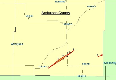
Areas with a white background above are served by the National Weather Service at Topeka Kansas. NWS-Wichita serves locations in green to the south, and the NWS-Kansas City serves locations to the east.
Tornado 1
Point A (near Colony): Minor structural damage to a home, an outbuilding destroyed, and several trees down.
Point B: Minor roof damage to a home, some trees down.
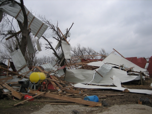
Point C: Power lines and trees down. One outbuilding destroyed. A large covered arena with steel girders and concrete footing was lifted out of the ground and moved about 100 feet.
Point D: Minimal damage to a home and a metal outbuilding. A large antenna was also knocked down.
Point E: A roof was stripped of shingles and windows were blown out of the south side of a home. Two outbuildings destroyed.
Point F: Two story home had a portion of the second story removed. Lots of tree damage. Tornado was it’s widest at this point- approximately 1/4 mile in diameter.
Point G: Minor damage to a home, and a roof blown off an outbuilding.
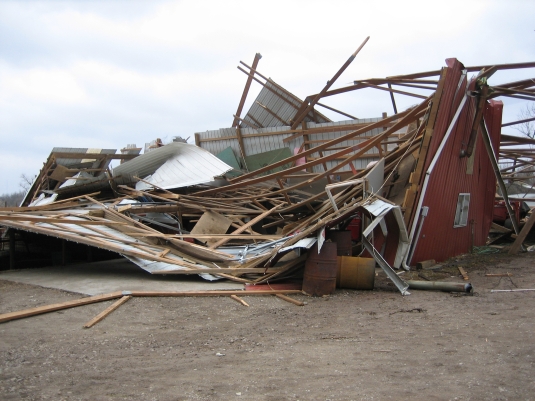
Point H: Two metal barns destroyed, and one large tree uprooted.
Tornado 2
Point A (near arrow): Minor tree damage.
Severe thunderstorms in east central Kansas also produced severe hail and strong wind gusts Wednesday evening. The first reports were called into the NWS-Topeka around 6:10pm. Hail up to the size of golfballs (1.75” in diameter), and wind gusts up to 60mph were reported to have occurred in the NWS-Topeka CWA.
Additional Information about the severe weather that occurred during the evening of Wednesday, February 8, 2007 can be found by visiting the following webpages.
Storm Prediction Center- US Storm Reports
...PRELIMINARY TORNADO DAMAGE SURVEY IN ANDERSON COUNTY...

THIS MORNING...PERSONNEL FROM NATIONAL WEATHER SERVICE TOPEKA AND
ANDERSON COUNTY EMERGENCY MANAGEMENT SURVEYED TORNADO DAMAGE THAT
OCCURRED IN THAT COUNTY WEDNESDAY EVENING FEBRUARY 28.

A SUPERCELL THUNDERSTORM MOVED ACROSS EAST CENTRAL KANSAS WEDNESDAY
EVENING...FROM WOODSON AND NORTHWEST ALLEN COUNTY INTO SOUTHERN
ANDERSON...AND THEN CONTINUED ON EASTWARD.  IN ANDERSON COUNTY...A
TORNADO TOUCHED DOWN JUST EAST OF COLONY AND MOVED
NORTHEAST...ENDING ABOUT 5 MILES NORTH NORTHEAST OF LONE ELM.

ALONG THE NINE MILE PATH OF THIS TORNADO...THE FOLLOWING DAMAGE WAS
OBSERVED...

2 MILES EAST OF COLONY...MINOR STRUCTURAL DAMAGE TO A HOME, ONE
OUTBUILDING DESTROYED AND SEVERAL TREES DOWN. DAMAGE WAS EF0.

5 MILES WEST NORTHWEST OF LONE ELM...MINOR ROOF DAMAGE TO A HOME,
SOME TREES DOWN.  DAMAGE WAS EF0.

3 MILES NORTHWEST OF LONE ELM...POWER LINES DOWN...TREES DOWN...ONE
OUTBUILDING DESTROYED. LARGE COVERED ARENA DESTROYED. LARGE SPAN
METAL BUILDING WITH STEEL GIRDERS AND CONCRETE FOOTINGS LIFTED OUT
OF THE GROUND. PEOPLE IN THE ARENA WENT INTO A SMALL INTERIOR
ROOM OR BATHROOM FOR SHELTER. ONE PERSON RIDING IN THE ARENA WAS
THROWN 100 FEET INTO A FIELD, BUT NOT INJURED. SINGLE STORY HOME
ADJACENT TO THE ARENA HAD MINOR DAMAGE. WINDOWS BLOWN OUT OF
VEHICLES. STRONG EF1

3 MILES NORTHWEST OF LONE ELM...SINGLE STORY MODERN WHITE HOUSE WITH
MINIMAL DAMAGE TO HOME. METAL OUTBUILDING DAMAGED. LARGE ANTENNA
KNOCKED DOWN. DAMAGE WAS EF0

4 MILES NORTH NORTHWEST OF LONE ELM...ROOF STRIPPED OF SHINGLES...
WINDOWS BLOWN OUT ON THE SOUTH SIDE OF THE HOME. TWO OUTBUILDINGS
DESTROYED. OLDER COUPLE MOVED TO THE BASEMENT.  DAMAGE WAS STRONG EF1

4 MILES NORTH NORTHWEST OF LONE ELM...OLDER TWO STORY WHITE HOUSE
WITH A LOT OF DAMAGE AND A PORTION OF THE SECOND STORY REMOVED.
LOCATED RIGHT ON HIGHWAYS 31 AND 59. TORNADO AT ITS WIDEST...AROUND
A QUARTER MILE WIDE AND DAMAGED THIS LOCATION AND PREVIOUS AT THE
SAME TIME. DAMAGE WAS STRONG EF1

4 MILES NORTH OF LONE ELM...MINOR DAMAGE TO HOME AND WINDOWS OUT.
ROOF OFF OF OUTBUILDING. DAMAGE WAS EF0.

5 MILES NORTH NORTHEAST OF LONE ELM...TWO METAL BARNS DESTROYED. ONE
LARGE TREE UPROOTED. VERY LITTLE DAMAGE TO THE ADJACENT HOME.
DAMAGE WAS EF1.

THE TORNADO WAS 200 TO 300 YARDS WIDE FOR MOST OF THE PATH AND UP TO
A QUARTER MILE WIDE. MAXIMUM DAMAGE WAS EF1 RATING WITH CONSIDERABLE
DAMAGE TO METAL OUTBUILDINGS...BUT LITTLE DAMAGE TO MOST HOMES. EF1
WIND SPEEDS RANGE FROM 86 TO 110 MPH.
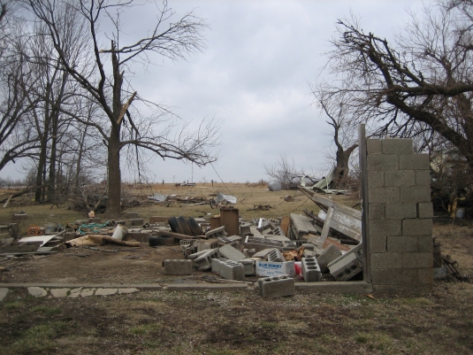
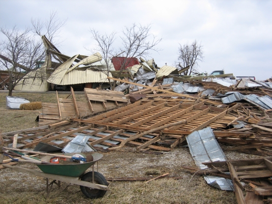
Below are some images taken of the damage: