
Widespread life-threatening flash and urban flooding continues in south-central Texas, with considerable flooding impacts possible across central Texas. Wildfire smoke is impacting air quality across much of the Great Lakes region into southern New England and the Mid-Atlantic. Monsoonal thunderstorms may produce isolated to scattered flash flooding across the Southwest into the Great Basin. Read More >
Below is a graphic that contains 48 hour snowfall totals from 7am Dec. 24th (Christmas Eve) through 7am Dec. 26th. These reports come courtesy of trained storm spotters, cooperative observers, and the CoCoRaHS network of precipitation observers. Thank you to all who have submitted reports. The daily temperature and precipitation totals table can be found HERE, and the Local Storm Reports HERE. Locally higher amounts can be noted in all generally analyzed areas.
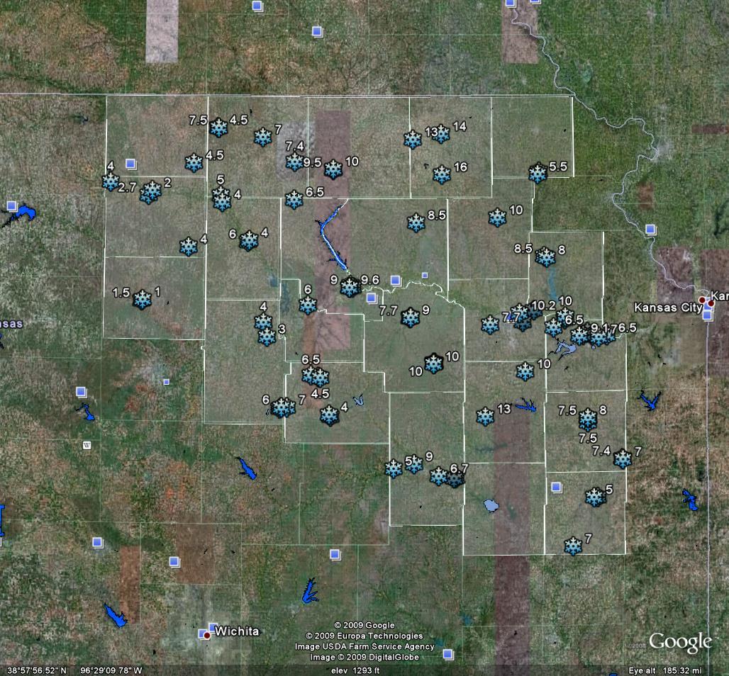
Above: Map depicts reports of snowfall from across the area
Images from The Christmas 2009 Snow Storm
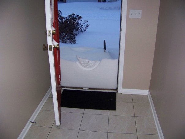
Above: 19" snow drift up to the front door of a residence in Lawrence, KS on Christmas morning
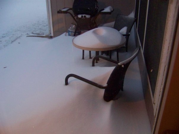
Above: Snow drifting over outdoor furniture in Lawrence, KS on Christmas morning
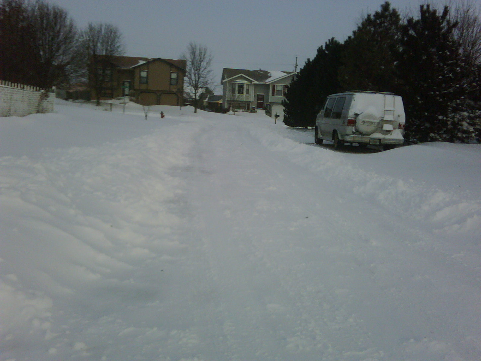
Above: Snow covered roads, like this one in Topeka, made travel very difficult on Christmas morning for much of northeast Kansas.
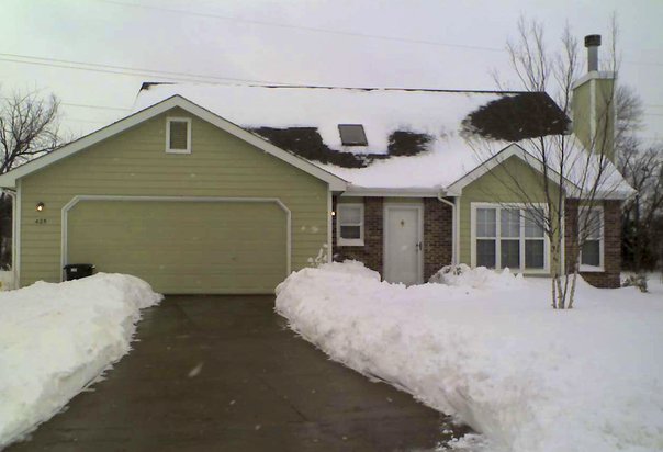
Above: Lawrence, KS received nearly 10 inches of snow between December 24th and December 26th
|
Location |
County | Storm Total |
| Garnett | Anderson | 5.0 |
| 7 WSW Topeka | Shawnee | 7.7 |
| 8 W Emporia | Lyon | 5.0 |
| 4 E Lawrence | Leavenworth | 6.5 |
| 2E Herington | Morris | 7.0 |
| Manhattan | Riley | 9.0 |
| 1 S Ottawa | Franklin | 7.5 |
| 4 E Carbondale | Osage | 10.0 |
| Ottawa | Franklin | 8.0 |
| White City | Morris | 4.5 |
| Wilsey | Morris | 4.0 |
| 1 W Concordia | Cloud | 2.7 |
| Manhattan | Riley | 9.6 |
| Minneapolis | Ottawa | 1.5 |
| Clifton | Washington | 5.0 |
| Clay Center | Clay | 4.0 |
| Herington | Dickinson | 6.0 |
| Lawrence | Douglas | 8.5 |
| 1 WSW Osage City | Osage | 13.0 |
| 3 SW Valley Falls | Jefferson | 8.5 |
| Lecompton | Douglas | 9.5 |
| Blue Rapids | Marshall | 9.5 |
| Lane | Franklin | 7.0 |
| McFarland | Wabaunsee | 7.7 |
| Eskridge | Wabaunsee | 9.5 |
| 3 SW Baileyville | Nemaha | 13.0 |
| Grantville | Jefferson | 9.0 |
| Neosho Rapids | Lyon | 7.0 |
| Haddam | Washington | 4.5 |
| Horton | Brown | 5.5 |
| Washington | Washington | 7.0 |
| Chapman | Dickinson | 3.0 |
| 1 E Garnett | Anderson | 6.0 |
| Onaga 3.1 WSW | Pottawatomie | 8.5 |
| Lawrence 2.2 W | Douglas | 9.4 |
| Topeka 4.6 ESE | Shawnee | 9.0 |
| Eskridge | Wabaunsee | 10.0 |
| Lawrence 3.1 W | Douglas | 9.1 |
| McFarland | Wabaunsee | 9.0 |
| Lawrence 1.3 NW | Douglas | 7.8 |
| White City 2.5 WNW | Morris | 6.5 |
| Barnes | Washington | 7.4 |
| Lawrence 1.6 ESE | Douglas | 7.0 |
| Emporia 5.6 ESE | Lyon | 6.7 |
| Manhattan 0.5 NE | Riley | 9.4 |
| Lecompton 4.3 SW | Douglas | 6.5 |
| Jamestown 2.4 NW | Cloud | 4.0 |
| Chapman | Dickinson | 4.0 |
| Clay Center | Clay | 6.0 |
| Concordia | Cloud | 2.0 |
| Emporia | Lyon | 9.0 |
| Eskridge | Wabaunsee | 10.0 |
| Fort Riley | Geary | 6.0 |
| Herington | Dickinson | 5.0 |
| Horton | Brown | 8.0 |
| Manhattan | Riley | 9.5 |
| Minneapolis | Ottawa | 7.5 |
| Ottawa | Franklin | 7.5 |
| Valley Falls | Jefferson | 8.0 |
| Agenda | Republic | 4.5 |
| Blue Rapids | Marshall | 10.0 |
| Clifton | Washington | 4.0 |
| Colony | Anderson | 7.0 |
| Haddam | Washington | 7.5 |
| Lane | Franklin | 7.4 |
| Lecompton | Douglas | 10.0 |
| McFarland | Wabaunsee | 8.7 |
| Miltonvale | Cloud | 4.0 |
| Neosho Rapids | Lyon | 7.0 |
| Parallel | Riley | 6.5 |
| White City | Morris | 4.5 |
| Wilsey | Morris | 4.0 |
| Corning | Nemaha | 16.0 |
| Seneca | Nemaha | 14.0 |
| Holton | Jackson | 10.0 |
The heavy snow was accompanied by extremely strong winds overnight. Below are some of the peak wind gusts reported across the area.
| Location | WindSpeed | Date | Time |
| Topeka Billard Arpt | 47 MPH | Dec. 25 | 1:47 am |
| Forbes Field | 48 MPH | Dec. 25 | 1:36 am |
| Concordia | 49 MPH | Dec. 25 | 2:11 am |
| Lawrence | 45 MPH | Dec. 25 | 1:03 am |
| Emporia | 54 MPH | Dec. 25 | 1:20 am |

