
Dangerous heat will expand from the Gulf Coast into the Southern Plains and Desert Southwest through week's end. Additional extreme heat impacting the Pacific Northwest will shift to the northern Plains by the weekend. Tropical Storm Bertha is expected to continue to impact portions of the northern Gulf Coast from the western Florida Panhandle to southeastern Louisiana through tonight. Read More >
Tornadoes and Large Hail Strike Northeast Kansas on April 14, 2012
On the afternoon and evening of April 14th, strong thunderstorms brought several rounds of severe weather which included many strong, long-tracked tornadoes. The event was unusual, in that the severity and strength of the wind fields feeding the storms was uncommonly strong for the Central Plains. One of the strongest tornadoes formed around 6:30 pm in central Kansas and moved northeastward into Rice County, where it produced a very strong quarter to a half mile wide tornado. The parent storm of this tornado then moved into Ottawa and Dickinson Counties, where it continued to produce tornadoes, until the storm finally weakened in eastern Clay County. Reports from Ottawa and Dickinson Counties indicate that a few farmsteads near Niles and Manchester were impacted by the tornado, as well as a gas transfer station along K-18 near Talmage. Additonal brief tornadoes were spotted near Burdick in Morris county, and near Olpe in Lyon county.
Numerous other storms affected the area on Saturday afternoon. An initial batch of storms formed north of Wichita around 2:00 pm, and moved northeastward into north central and northeastern Kansas. These storms were only marginally severe as the largest hail size reported with these storms was 1.5" near Summerfield. The second round of storms moved into the area a few hours later, and included the aforementioned tornado, which caused damage near Niles, Manchester, and Talmage. Another round of thunderstorms moved into the area around midnight and brought more large hail, and possibly a tornado or two. The largest hail measured from these storms was 4.5 inches in diameter near Randolph. By 3:00 a.m., the storms finally weakened to a point that severe weather was no longer a concern.
(Click points along the track for photos)
|
April 14, 2012 |
|
EF-0 |
EF-1 |
EF-2 |
EF-3 |
EF-4 |
EF-5 |
|
Tornado tracks and damage contours are based on individual damage points and should not be expected to be fully accurate down to the sub-neighborhood level. |
View April 14, 2012 - Ottawa/Dickinson Tornado in a larger map
* Click on the link above "April 14, 2012 - Ottawa/Dickinson Tornado" to be taken to a Google Maps page where .kml files can be downloaded.
* Follow this link to NWS Wichita's continued tornado survey for Saline county and points southwest.
|
Click on the points above to see pictures of the tornado and damage photos. Tornado 1 Beginning Time: 7:02 pm
Ending Time: ~7:20 pm
Beginning Location: 2 miles south of Niles (Extension of tornado from Saline County)
Ending Location: 1 mile west of Manchester
Path Length: ~11 miles
Maximum Width: 100 yards
Deaths: 0
Injuries: 0
EF-Scale Rating: EF-1
EF-1 Estimated Wind Speed: 86-100 mph
Very few damage indicators were evident as the tornado traveled over mostly open area. The most significant damage was located near K-18 and Solomon Road in Ottawa County where a gas transfer station showed some structural damage and power poles nearby were snapped at the base. This tornado track is an extension of the same tornado which crossed into Ottawa County from Saline County approximately 7:00 pm. The exact location of the end point of the tornado is uncertain as it dissipated over open fields. Rough dissipation location and time is 7:20 pm about 1 mile southest of Manchester. Tornado 2 Beginning Time: ~7:31 pm
Ending Time: ~7:36 pm
Beginning Location: ~6 miles northeast Manchester
Ending Location: ~9 miles northeast Manchester
Path Length: ~3 miles
Maximum Width: 25 yards
Deaths: 0
Injuries: 0
EF-Scale Rating EF-0
EF-0 Estimated Wind Speed: 65-85 mph
There were also several brief tornado touchdowns northeast of Manchester reported by several storm spotters.
|
Local Storm Report Map
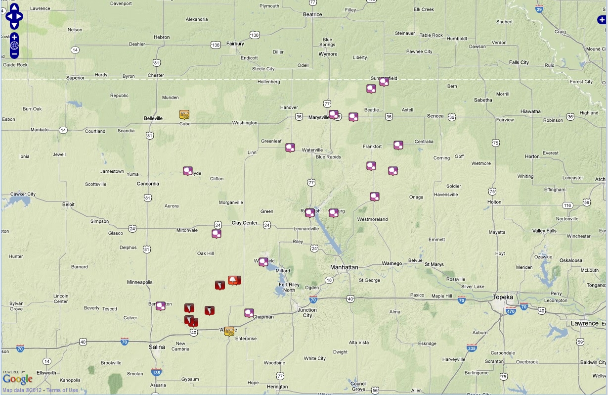
Above: Map of severe weather reports from across northeast Kansas (click image for an interactive LSR map).

