
Extreme heat continues across the Southwest as temperatures may top 120 degrees. The heat may expand across the West and south-central U.S. into the middle of the month. Severe thunderstorms capable of severe wind gusts and large hail will be the primary hazards today across the northern Plains into the upper Midwest. Rainfall could be locally heavy across the Eastern U.S. today. Read More >
Overview
A long lived supercell moved southeast across eastern Kansas on July 11. This storm produced a 100 mile long swath of large hail in excess of 1 inch. Reports of four inch hail were received from both Wabaunsee and Coffey Counties.
Photos & Video
Header
 |
 |
 |
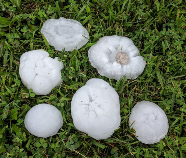
| Hail up to 4.5" wide near Dover, KS. (Jayson Prentice) |
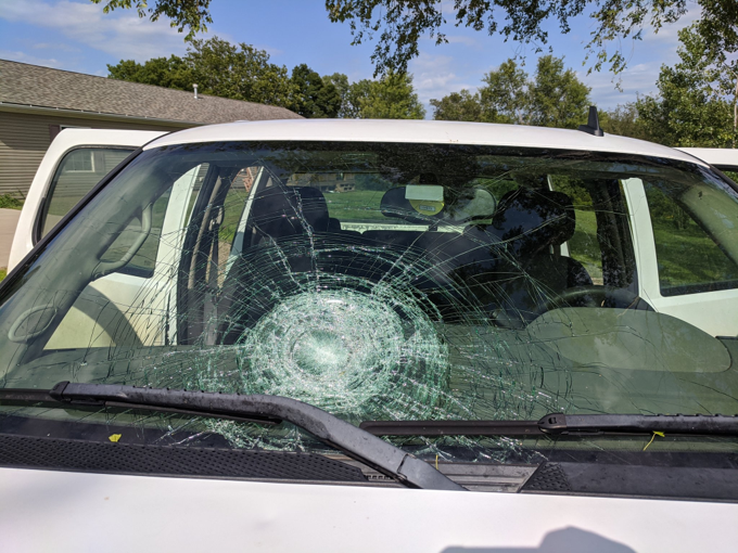
Car windshield destroyed by large hail near Dover. (Jayson Prentice) |
Softball size hail near Maple Hill, KS (Karen Kraus) |
 |
 |
 |
| 4.1" wide hail 3 miles north of Paxico. (Anna Lukert) |
4 inch hail in Waverly around 3:07 PM. (Courtney Moloney) |
4 inch hail in Waverly. (Courtney Moloney) |
Radar and Environment
Radar
 |
 |
 |
 |
| Radar at 12:59 PM - Storm over Westmoreland | Radar at 1:38 PM - Storm over Maple Hill | Radar at 2:12 PM - Storm over Auburn | Radar at 3:04 PM - Storm over Waverly |
Environment
 |
 |
 |
| 18z (1PM CDT) Topeka Sounding. Weak low-level shear but strong deep-layer shear and steep lapse rates. | Storm Prediction Center 1630z convective outlook. The outlook highlighted the potential for significant (2"+) hail. | SPC mesoscale discussion graphic at 12:43 PM. Highlighted potential for very large hail across northeast Kansas, given 50 kts of effective shear and 2500-4000 J/kg of mixed-layer CAPE. |
Storm Reports
 |
 |
| National view of severe weather reports on July 11. Note several long swaths of damaging winds and large hail. | Zoomed in view of hail reports across eastern Kansas on July 11. |
HAIL REPORT SUMMARY...

..TIME...   ...EVENT...      ...CITY LOCATION...     ...LAT.LON...
..DATE...   ....MAG....      ..COUNTY LOCATION..ST.. ...SOURCE....
            ..REMARKS..

0155 PM     HAIL             3 NW DOVER              38.99N 95.98W
07/11/2020  E4.00 INCH       WABAUNSEE          KS   PUBLIC


0150 PM     HAIL             4 ESE PAXICO            39.06N 96.10W
07/11/2020  E1.75 INCH       WABAUNSEE          KS   TRAINED SPOTTER


0157 PM     HAIL             2 NW DOVER              38.99N 95.97W
07/11/2020  E3.00 INCH       WABAUNSEE          KS   TRAINED SPOTTER

            SPOTTER REPORTED UP TO 3.5 INCH HAIL.

0315 PM     HAIL             2 SW TECUMSEH           39.03N 95.61W
07/11/2020  M1.00 INCH       SHAWNEE            KS   PUBLIC


0221 PM     HAIL             1 N AUBURN              38.91N 95.82W
07/11/2020  E1.00 INCH       SHAWNEE            KS   NWS EMPLOYEE


0205 PM     HAIL             4 S DOVER               38.91N 95.93W
07/11/2020  E2.00 INCH       SHAWNEE            KS   PUBLIC

            SOCIAL MEDIA POST SHOWING UP TO 2 INCH HAIL.

0127 PM     HAIL             WAMEGO                  39.20N 96.30W
07/11/2020  E1.75 INCH       POTTAWATOMIE       KS   STORM CHASER


0103 PM     HAIL             WESTMORELAND            39.39N 96.41W
07/11/2020  E1.75 INCH       POTTAWATOMIE       KS   TRAINED SPOTTER


0100 PM     HAIL             WESTMORELAND            39.39N 96.42W
07/11/2020  E2.75 INCH       POTTAWATOMIE       KS   PUBLIC

            SEVERAL LARGE SIZE HAILSTONES FALLING WITH
            SOME OF THE LARGEST BEING BASEBALL ALONG
            WITH GOLF BALL SIZE HAIL.
0155 PM     HAIL             4 W DOVER               38.96N 96.02W
07/11/2020  M4.50 INCH       WABAUNSEE          KS   STORM CHASER

            DELAYED REPORT OF 4.5 INCH. RECEIVED ON
            SOCIAL MEDIA.
0220 PM     HAIL             3 SW AUBURN             38.87N 95.85W
07/11/2020  E1.75 INCH       OSAGE              KS   TRAINED SPOTTER


0218 PM     HAIL             5 SW AUBURN             38.84N 95.87W
07/11/2020  E2.00 INCH       OSAGE              KS   PUBLIC

            SOCIAL MEDIA POST SHOWING UP TO 2 INCH HAIL.

0309 PM     HAIL             1 S WAVERLY             38.38N 95.60W
07/11/2020  E2.00 INCH       COFFEY             KS   PUBLIC


0307 PM     HAIL             WAVERLY                 38.39N 95.60W
07/11/2020  E4.00 INCH       COFFEY             KS   LAW ENFORCEMENT

            TIME ESTIMATED BY RADAR.

0357 PM     HAIL             4 NW LONE ELM           38.13N 95.30W
07/11/2020  E1.00 INCH       ANDERSON           KS   TRAINED SPOTTER


0353 PM     HAIL             5 SSW GARNETT           38.22N 95.28W
07/11/2020  E1.75 INCH       ANDERSON           KS   EMERGENCY MNGR


0351 PM     HAIL             4 NW LONE ELM           38.13N 95.30W
07/11/2020  E1.00 INCH       ANDERSON           KS   EMERGENCY MNGR


0339 PM     HAIL             5 W GARNETT             38.28N 95.33W
07/11/2020  E2.00 INCH       ANDERSON           KS   PUBLIC


0337 PM     HAIL             3 SSE HARRIS            38.28N 95.42W
07/11/2020  M3.00 INCH       ANDERSON           KS   TRAINED SPOTTER

            MEASURE 3.25 INCH HAIL.

0328 PM     HAIL             5 N WESTPHALIA          38.25N 95.49W
07/11/2020  E1.00 INCH       ANDERSON           KS   CO-OP OBSERVER
 |
Media use of NWS Web News Stories is encouraged! Please acknowledge the NWS as the source of any news information accessed from this site. |
|

