The movement of goods by sea is the backbone of global commerce, and its safety and efficiency rely heavily on accurate, real-time environmental data. National Oceanic and Atmospheric Administration (NOAA)’s National Ocean Service (NOS), specifically through its Center for Operational Oceanographic Products and Services (CO-OPS), manages critical oceanographic and meteorological monitoring programs that directly support maritime commerce across the United States and its territories.
Key CO-OPS Programs Supporting Commerce
CO-OPS operates and maintains two primary systems that provide essential real-time data for safe and efficient navigation: the National Water Level Observation Network (NWLON) and the Physical Oceanographic Real-Time System (PORTS®).
The National Water Level Observation Network (NWLON)
NWLON is the foundation of U.S. water level monitoring. This network of continuously operating water level stations provides the tidal, Great Lakes, and coastal sea level data necessary for charting, coastal engineering, and navigation. Many NWLON stations have co-located meteorological observing equipment.
Impact on Commerce: Accurate, real-time water level data ensures mariners can calculate under-keel clearance for safe transit in shallow channels and docking, minimizing delays and maximizing cargo capacity for efficient commercial shipping.
Physical Oceanographic Real-Time System (PORTS®)
PORTS® is a shared responsibility partnership program and a suite of integrated real-time sensors designed specifically to reduce marine transportation accidents and improve the efficiency of ports and harbors. PORTS® stations provide water level, current, and meteorological observations, all crucial inputs for safe vessel movements. Currently PORTS are established in 41 locations around the U.S..
The Specific Role of Meteorological Data
Within both NWLON and PORTS®, CO-OPS collects and manages a vast array of meteorological (Met) data at more than 300 geographic locations, including wind speed, gust, wind direction, air temperature, barometric pressure, and visibility. This data is critical for real-time decision-making on the water.
CO-OPS meteorological data plays a pivotal role in the broader weather safety infrastructure. All CO-OPS -managed Met data is openly displayed and disseminated by NOAA's National Data Buoy Center (NDBC). Furthermore, this essential data is actively pulled and utilized by local National Weather Service (NWS) Weather Forecast Offices, who integrate it into their marine forecasts and warnings. This ensures that mariners receive the most current and reliable weather information directly from official sources.

The National Ocean Services’ CO-OPS collects and manages a vast array of meteorological data at more than 300 geographic locations in the U.S. and U.S. Territories.
Data Accessibility: Public and Persistent
A core principle of NOAA's mission is the open and free accessibility of environmental data. All data from NWLON and PORTS, including the real-time meteorological observations, is publicly available for use by government agencies, commercial shipping operators, recreational boaters, and the general public. This commitment to transparency and open data ensures that all stakeholders in the maritime community have the necessary tools to make informed decisions, ultimately enhancing safety and supporting the continued growth of U.S. maritime commerce.

A meteorological station as part of the new NOAA Boston Harbor PORTS, collects vital wind data at Massports Conley Container Terminal on Boston Harbor in support of deep draft vessel and cruise ship movements.
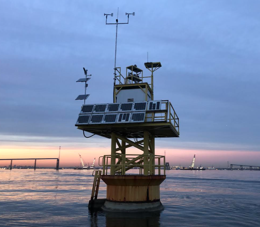
A meteorological station installed on Brewerton Channel Range Front Light as part of the Chesapeake Bay North PORTS provides critical, real-time info for deep-draft vessels transiting near the former Francis Scott Key bridge.

