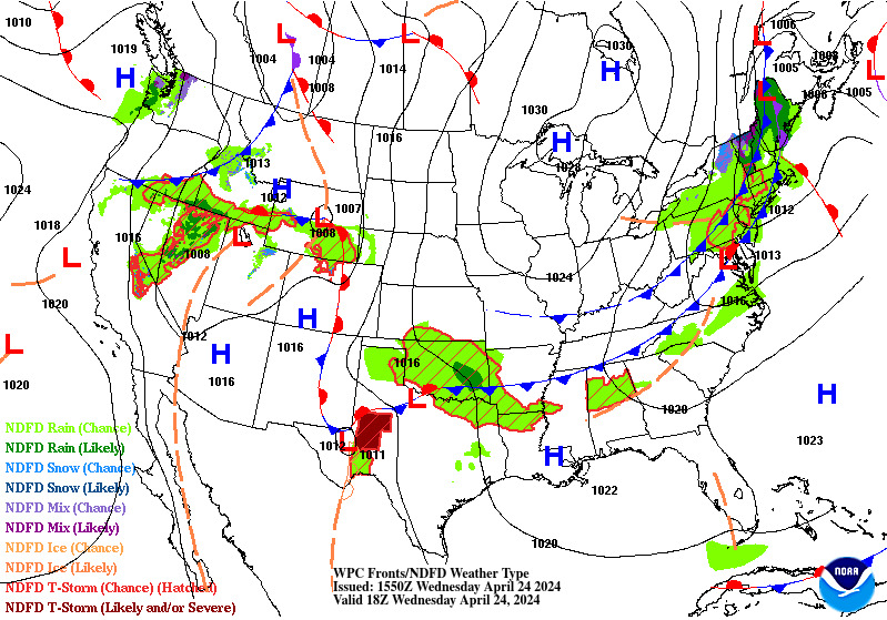
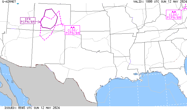
National Weather Service United States Department of Commerce

Heavy Lake Effect Snow; Subfreezing Temperatures in the Eastern U.S.

A multi-day heavy lake effect snow event is expected downwind of Lakes Erie and Ontario through New Year's Day. The Arctic front will continue to bring increasing winds to the Northeast that will remain gusty. Subfreezing overnight low temperatures will be found as far south as the Gulf Coast. Read More >


MSY TRACON Briefing Page
NOTE: Click on images below to expand/minimize
ZHU CWSU Contact Info: 281-230-5676


Local Observations and TAFs
MSY Observations and TAF
NEW Observations and TAF
Local TAFs


Local NWS Forecasts
MSY Hourly Forecast
NEW Hourly Forecast


Radar Imagery
CONUS Sector
Southern Mississippi Valley Sector
New Orleans Radar


Satellite Imagery
IR Satellite Imagery
Geocolor Satellite Imagery


Surface Analysis
South Central US
United States


Observations


PIREPs


6-Hour Surface Front/Precipitation Forecasts
6 Hour Forecast
12 Hour Forecast
18 Hour Forecast
24 Hour Forecast


Days 1-3 Overview
Day 1
Day 2
Day 3


SPC Convective Outlook Products
SPC Day 1
SPC Day 2
SPC Day 3
SPC Days 4-8


TCF
TCF 4 Hour Forecast
TCF 6 Hour Forecast
TCF 8 Hour Forecast
TCF Legend


SIGMETs
Latest SIGMETs (ALL Parameters)


Turbulence
G-AIRMET - 00 HR
G-AIRMET - 03 HR
G-AIRMET - 06 HR
G-AIRMET - 09 HR
G-AIRMET - 12 HR


Icing
G-AIRMET - 00 HR
G-AIRMET - 03 HR
G-AIRMET - 06 HR
G-AIRMET - 09 HR
G-AIRMET - 12 HR


Ceiling and Visibility
G-AIRMET - 00 HR
G-AIRMET - 03 HR
G-AIRMET - 06 HR
G-AIRMET - 09 HR
G-AIRMET - 12 HR
 
AWC CLOUDS 03 HR
AWC CLOUDS 06 HR
AWC CLOUDS 09 HR
AWC CLOUDS 12 HR
AWC CLOUDS 15 HR
 
AWC SFC 03 HR
AWC SFC 06 HR
AWC SFC 09 HR
AWC SFC 12 HR
AWC SFC 15 HR


Tropical
NHC 7 Day Tropical Outlook)
NHC 2 Day Tropical Outlook)