
Scattered thunderstorms and widespread showers are expected from the Texas coast to the central Appalachians today. Heavy to excessive rainfall will continue in southern California into the Desert Southwest through Saturday. Heavy rain will pose a risk of flash flooding, especially across burn scar and urbanized regions. Read More >
Overview
|
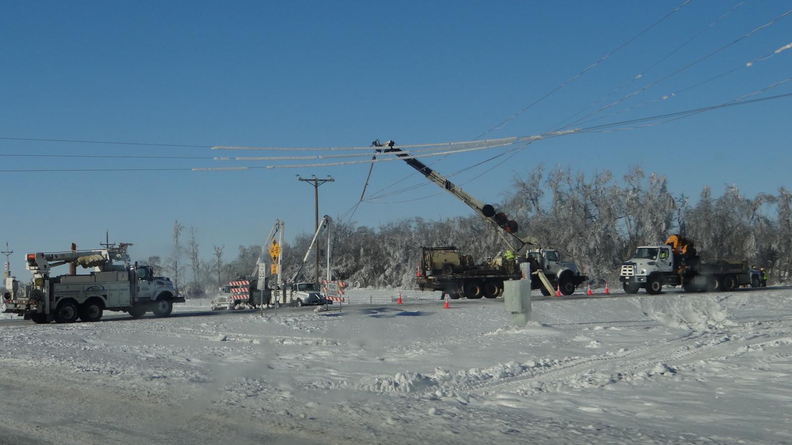
An intense surface low pressure area moved from northeast Colorado to South Dakota from the 24th through the 26th. This storm was unusually warm for the region for late December and produced record breaking heavy rain along with flooding in some cases. Significant icing of locally over an inch occurred across areas at or just below the freezing point, which resulted in widespread tree and power pole and line damage to those areas. This was one of the worst ice storms to affect South Dakota since November of 2005. The ponding of the heavy rain froze overnight once much colder air moved in. Roads and walkways became treacherous ice rinks and remained as such for many days. There were numerous injuries from slips on the ice, as well as several vehicular accidents and flight cancellations. Some downed branches and trees fell onto homes across the region. This storm also brought high winds of 60 to 70 plus mph, along with snow and blizzard conditions to the region. This significant storm resulted in massive power outages with over 12,000 people without power (for some for more than 10 days despite tireless efforts), stranded motorists and closed roads. Water and sewer systems shut down for several days for some communities and emergency shelters were necessary. Deuel, Day, Marshall, Roberts and Grant counties were the hardest hit. Due to widespread significant impacts, the Governor of South Dakota declared a State of Emergency on the 26th which helped facilitate the movement of out-of-state crews to aid with power restoration. There was also a Presidential Disaster Declaration for damage to public property. The total estimated damage was near 8 million dollars for central and northeast South Dakota. |
 Radar loop from 9 am to 9 pm Christmas Day. Freezing rain is not depicted. |
Blizzard & Wind:
Strong winds in excess of 60 mph impacted South Dakota on the 25th and 26th. Across central and western South Dakota, these winds were associated with falling snow which resulted in a blizzard. It began during the afternoon on the 25th and subsided for a time in the evening before picking up once again during the overnight into the 26th. Very strong northwest winds then moved east and impacted northeast South Dakota during the morning and afternoon hours on the 26th, and just enough snow mixed in from the departing system to result in a blizzard with greatly reduced visibility. These high winds struck already vulnerable/damaged trees and power lines due to heavy icing from freezing rain that occurred earlier on the 25th.
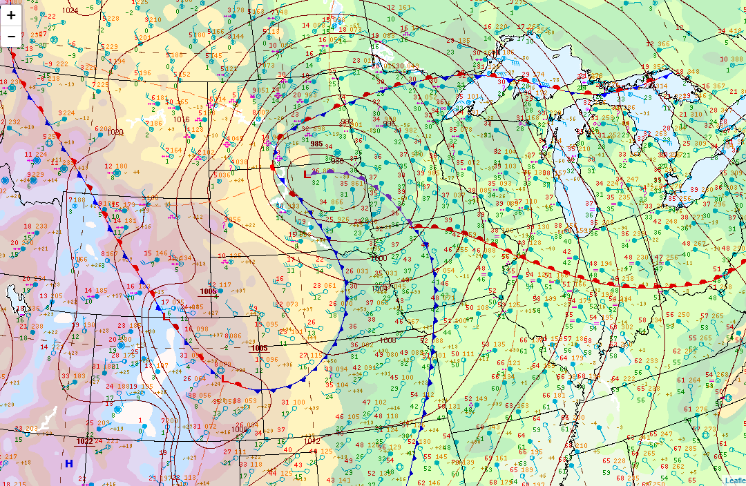 Surface analysis at 12am on the 26th (Click to Enlarge). Interactive storm reports map here: https://mesonet.agron.iastate.edu/lsr/#ABR,FGF,BIS,UNR,FSD/201612240600/201612281800/0101 |
| Report Time | County | Location | Event Type | Mag. | Source | Remark |
| 12/25/16 12:30 | CAMPBELL | MOUND CITY | BLIZZARD | 0.00 | EMERGENCY MNGR | FREEZING RAIN/SLEET IN THE MORNING, THEN BLIZZARD AFTER ABOUT NOON. CONDITIONS IMPROVED LATER THAT EVENING, BUT WORSENED TO BLIZZARD ONCE AGAIN AFTER ABOUT 3 AM ON THE 26TH. |
| 12/25/16 15:35 | DEWEY | TIMBER LAKE | BLIZZARD | 0.00 | PUBLIC | VISIBILITY NEAR ZERO FOR APPROXIMATELY 8 HOURS. |
| 12/25/16 16:32 | WALWORTH | MOBRIDGE | BLIZZARD | 0.00 | EMERGENCY MNGR | VISIBILITY LESS THAN A QUARTER MILE FROM LATE AFTERNOON ON CHRISTMAS INTO MONDAY. CONDITIONS EXISTED THROUGHOUT MOST OF THE COUNTY. |
| 12/26/16 1:00 | POTTER | GETTYSBURG | BLIZZARD | 0.00 | LAW ENFORCEMENT | VISIBILITY LESS THAN 1/4 MILE FROM JUST AFTER MIDNIGHT UNTIL NOON ON MONDAY. |
| 12/26/16 7:00 | EDMUNDS | ROSCOE | BLIZZARD | 0.00 | EMERGENCY MNGR | VISIBILITY LESS THAN 0.25 MILES IN SNOW AND BLOWING SNOW MOST OF THE MORNING. . |
| 12/26/16 8:11 | FAULK | ONAKA | BLIZZARD | 0.00 | EMERGENCY MNGR | VISIBILITY NEAR ZERO FROM APPROXIMATELY 8 AM UNTIL NEAR NOONTIME IN NORTHERN PORTION OF COUNTY. |
| 12/26/16 11:30 | BROWN | COLUMBIA | BLIZZARD | 0.00 | EMERGENCY MNGR | NEAR WHITEOUT CONDITIONS FROM COLUMBIA TO ABERDEEN FROM 830 AM TO 1130 AM MONDAY MORNING. |
| 12/26/16 12:00 | HAMLIN | 2 S THOMAS | BLIZZARD | 0.00 | EMERGENCY MNGR | WHITEOUT CONDITIONS AND NEAR IMPOSSIBLE TRAVEL NORTH OF HAYTI FROM AROUND 630 AM TO 12 PM MONDAY. |
| 12/26/16 12:00 | DEUEL | CLEAR LAKE | BLIZZARD | 0.00 | EMERGENCY MNGR | BLIZZARD CONDITIONS WITH LESS THAN 0.25 MILE VISIBILITY ACROSS DEUEL COUNTY FROM AROUND 830 AM TO 12 PM MONDAY. |
| 12/26/16 13:00 | DAY | WEBSTER | BLIZZARD | 0.00 | LAW ENFORCEMENT | BLIZZARD CONDITIONS REPORTED ACROSS DAY COUNTY WITH LESS THAN 0.25 MILE VISIBILITY FROM ABOUT 9 AM TO 1 PM MONDAY. |
| 12/26/16 14:00 | ROBERTS | 3 NW PEEVER | BLIZZARD | 0.00 | EMERGENCY MNGR | NEAR WHITEOUT CONDITIONS ALONG I-29 SOUTH OF SISSETON TO WILMOT FROM 530 AM TO 3 PM MONDAY. |
| 12/26/16 14:00 | MARSHALL | LAKE CITY | BLIZZARD | 0.00 | EMERGENCY MNGR | BLIZZARD CONDITIONS WITH LESS THAN 0.25 MILE VISIBILITY FROM LAKE CITY TO EDEN. FROM ABOUT 9 AM TO 2 PM. |
| 12/26/16 15:00 | CLARK | 1 N CLARK | BLIZZARD | 0.00 | EMERGENCY MNGR | WHITEOUT CONDITIONS BETWEEN CLARK AND HENRY FROM ABOUT 11 AM TO 3 PM MONDAY. |
| 12/25/16 23:10 | BUFFALO | 3 N GANN VALLEY | NON-TSTM WND GST | 44.00 | MESONET | SUSTAINED 44 MPH WITH GUSTS OF 58 MPH. |
| 12/25/16 23:15 | LYMAN | 9 NNW VIVIAN | NON-TSTM WND GST | 69.00 | MESONET | SUSTAINED 52 MPH WITH GUSTS OF 69 MPH. |
| 12/25/16 23:18 | HUGHES | 2 ENE PIERRE | NON-TSTM WND GST | 65.00 | ASOS | PEAK GUST SO FAR OF 65 MPH. |
| 12/25/16 23:29 | LYMAN | 3 SE RELIANCE | NON-TSTM WND GST | 72.00 | MESONET | SUSTAINED WINDS OF 59 MPH WITH GUST OF 72 MPH. |
| 12/25/16 23:40 | SULLY | 3 S GORMAN | NON-TSTM WND GST | 53.00 | MESONET | SUSTAINED 42 MPH WITH GUSTS OF 53 MPH. |
| 12/25/16 23:54 | HYDE | 1 NNE STEPHAN | NON-TSTM WND GST | 62.00 | MESONET | SUSTAINED 48 MPH WITH GUSTS OF 62 MPH. |
| 12/26/16 0:41 | HAND | 6 E DANFORTH | NON-TSTM WND GST | 62.00 | MESONET | SUSTAINED 49 MPH WITH GUSTS OF 62 MPH. |
| 12/26/16 0:45 | HUGHES | 4 WSW BLUNT | NON-TSTM WND GST | 63.00 | MESONET | SUSTAINED 44 MPH WITH GUSTS OF 63 MPH. |
| 12/26/16 1:16 | HYDE | 17 W POLO | NON-TSTM WND GST | 62.00 | PUBLIC | SUSTAINED 51 MPH WITH GUSTS OF 62 MPH. |
| 12/26/16 2:06 | HAND | 5 E ORIENT | NON-TSTM WND GST | 65.00 | MESONET | SUSTAINED WINDS OF 48 MPH WITH GUSTS OF 65 MPH. |
| 12/26/16 2:41 | SPINK | 1 NW MELLETTE | NON-TSTM WND GST | 55.00 | MESONET | SUSTAINED WINDS OF 41 MPH WITH GUSTS OF 55 MPH. |
| 12/26/16 2:41 | SPINK | 1 WNW MELLETTE | NON-TSTM WND GST | 55.00 | MESONET | SUSTAINED WINDS OF 41 MPH WITH GUSTS OF 55 MPH. |
| 12/26/16 2:41 | POTTER | TOLSTOY | NON-TSTM WND GST | 56.00 | MESONET | SUSTAINED 42 MPH WITH GUSTS OF 56 MPH. |
Additional Wind Reports:
Location                     Speed     Time/Date       Lat/Lon
Danforth 5 E                 71 MPH    0341 AM 12/26   44.24N/98.77W
Pierre Muni AP               70 MPH    1208 AM 12/26   44.38N/100.29W
Clear Lake 7 W               67 MPH    0359 AM 12/26   44.75N/96.83W
Aberdeen 6.5 W               63 MPH    0528 AM 12/26   45.47N/98.62W
Lees Corner 8 E              60 MPH    0230 AM 12/26   44.08N/99.15W
Aberdeen 7 W                 60 MPH    0340 AM 12/26   45.47N/98.64W
Miller 1 ENE                 59 MPH    0115 AM 12/26   44.53N/98.96W
Watertown Muni AP            56 MPH    0535 AM 12/26   44.91N/97.15W
Onida 1 W                    56 MPH    1235 AM 12/26   44.70N/100.10W
Aberdeen Rgnl AP             53 MPH    0640 AM 12/26   45.46N/98.41W
Faulkton                     53 MPH    0215 AM 12/26   45.03N/99.11W
Sisseton Muni AP             52 MPH    1002 AM 12/26   45.67N/97.00W
Britton 1 NNE                52 MPH    0735 PM 12/25   45.82N/97.74W
Graceville 2 W               52 MPH    0635 AM 12/26   45.56N/96.49W
Pierre 1 SW                  51 MPH    1213 AM 12/26   44.36N/100.34W
Odessa 1 W                   49 MPH    0651 AM 12/26   45.26N/96.34W
Ortonville                   49 MPH    0554 AM 12/26   45.31N/96.42W
Barnard 5 W                  46 MPH    0401 AM 12/26   45.72N/98.61W
Wheaton                      46 MPH    0956 AM 12/26   45.78N/96.54W
Snow & Ice
Snowfall totals were highest across northwest South Dakota (6-12") and North Dakota (over 18" in some cases) with this system from the morning through the evening on Christmas Day. The COOP observation at McIntosh found 9" of snow in a 24 hour period, and 13" of snow totaled in Keldron (northwestern Corson County). In all cases, high winds mixed in to create an impactful blizzard. Mobridge set a daily record of 4.8" of snow on the 25th (2.0" in 1988).
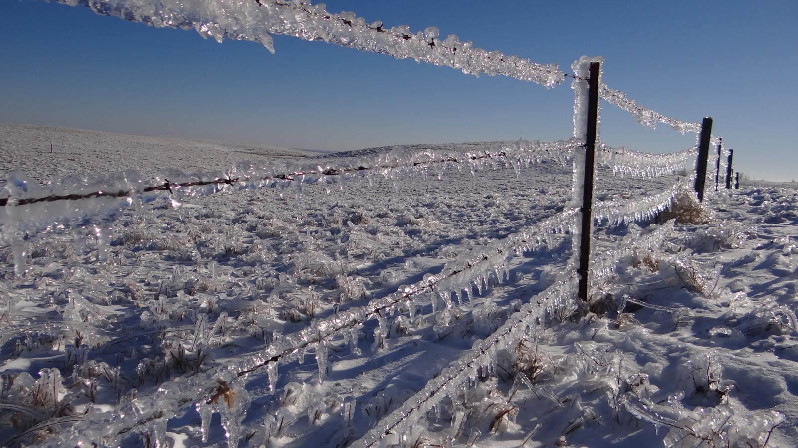
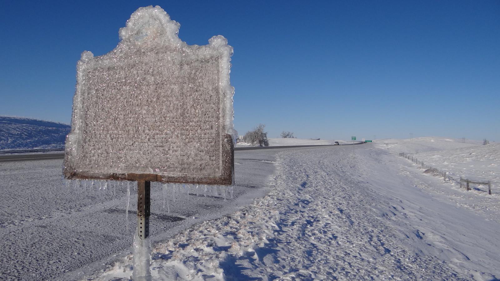
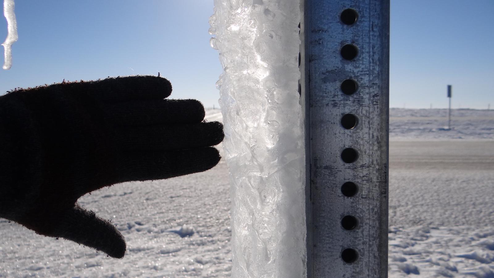
Ice accumulations were significant across central, northern, and northeastern South Dakota. Ice accumulations of over 1" occurred as heavy rain froze on contact in areas of near or sub-freezing surface temperatures. Strong winds during this event increased the amount of damage. Those who did not see freezing rain accumulations on trees and other objects had to deal with ice as well, once ponding from hours of heavy rain froze overnight due to sub-freezing temperatures. Roads became ice rinks and remained as such for several days. It's possible that a reverse downslope wind event due to strong east winds blowing across the Sisseton Hills kept the air just warm enough to prevent major ice accumulations across the James River Valley.
.png) Snow Reports (Click to Enlarge). Interactive storm reports map here: https://mesonet.agron.iastate.edu/lsr/#ABR,FGF,BIS,UNR,FSD/201612240600/201612281800/0101 |
 |
 |
 |
 |
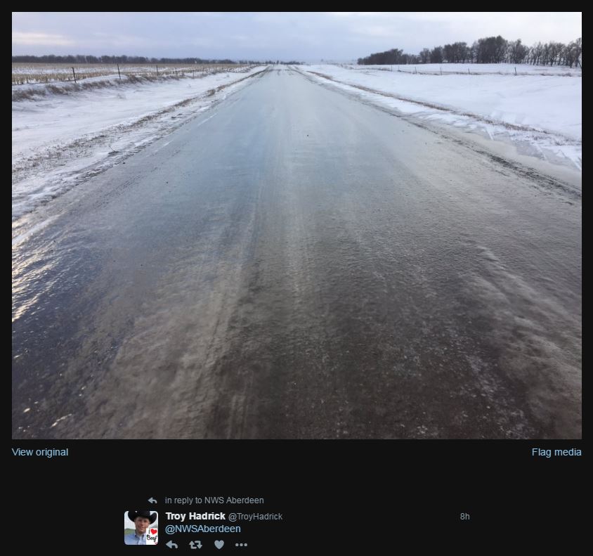
| Ice covered road 4 mi W of Faulkton, via Troy Hadrick on Twitter | 5 mi S of Vayland at 11:45 am on the 25th, via Hand County EM | 5 mi S of Vayland at 11:45 am on the 25th, via Hand County EM | Roadway at Richmond Lake on the 28th |
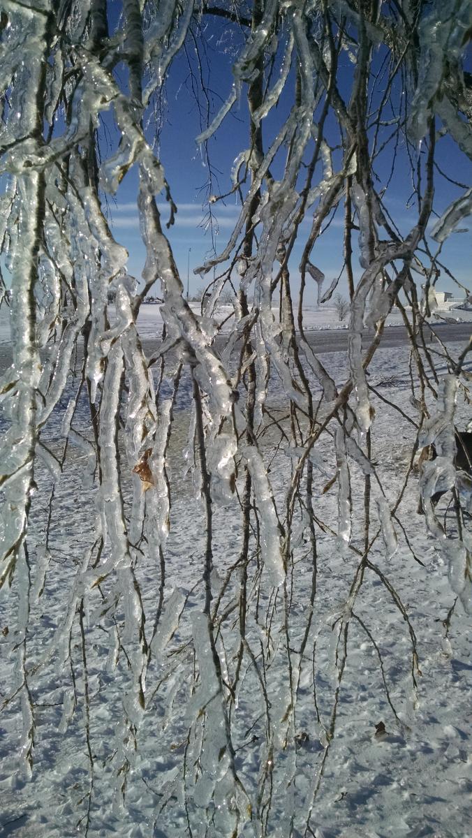  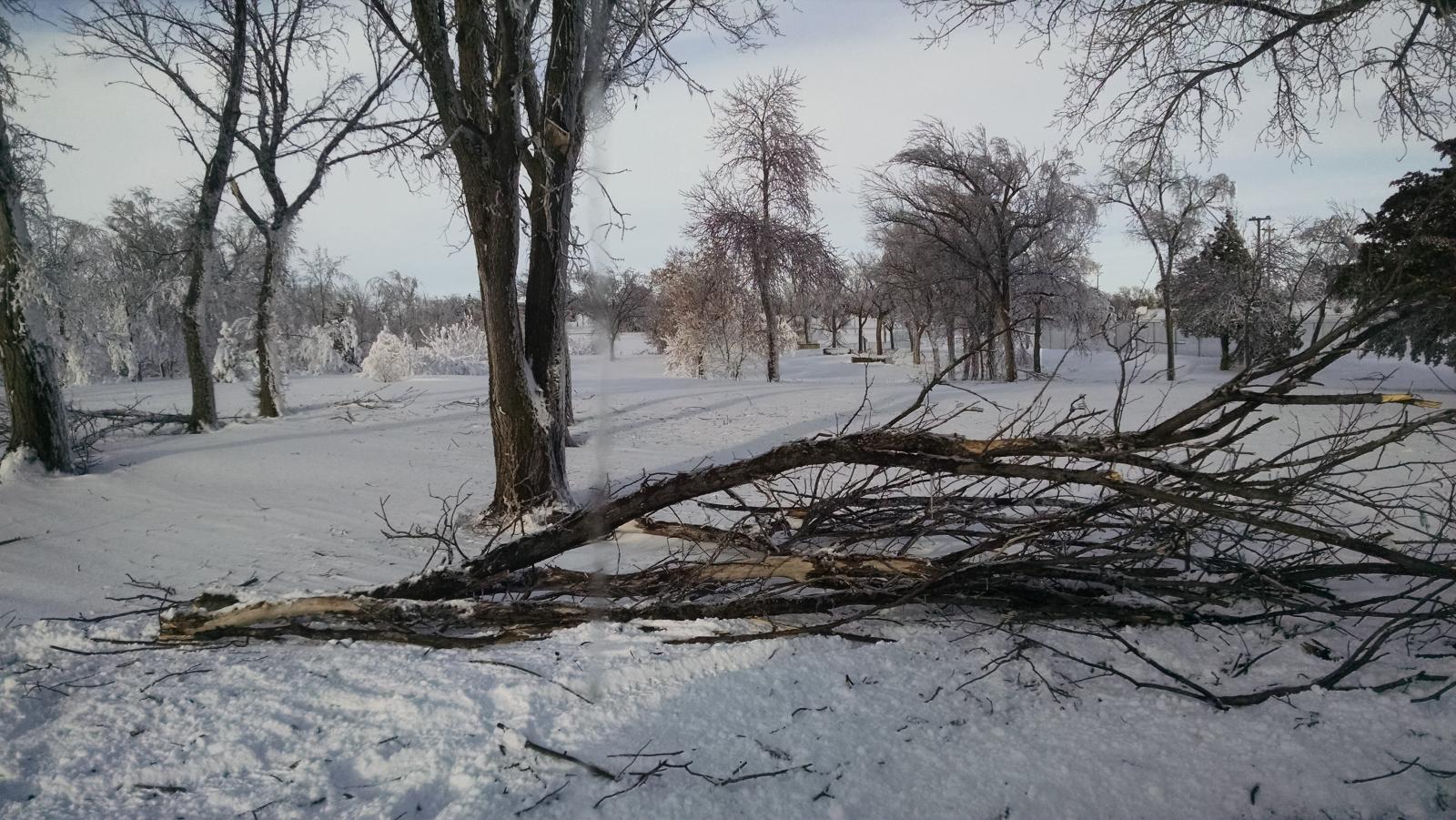  |
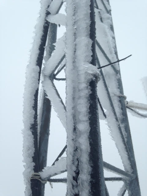
Inch-thick ice on tree in Eureka Measured on the 26th in Eureka Tree limbs down in Eureka Taken in Wetonka by Kristen Kramlich
 |
 |
 |
 |
| Along Hwy 12 near Summit on the 27th | Along Hwy 12 at the Grant/Roberts county line on the 27th | Along Hwy 12 near Summit on the 27th | Along Hwy 12 near the I-29 intersection on the 27 |
| Report Time | County | Location | Event Type | Mag. | Source | Remark | |
| 12/25/16 8:30 | STANLEY | 6 E HAYES | FREEZING RAIN | 0.01 | CO-OP OBSERVER | ROADS AND OTHER SURFACES VERY ICY. | |
| 12/25/16 9:30 | HAND | MILLER | FREEZING RAIN | 0.01 | LAW ENFORCEMENT | HAND COUNTY SHERIFF REPORTS EVERYTHING IS ICY. REPORT RELAYED VIA SOCIAL MEDIA. | |
| 12/25/16 9:41 | HUGHES | 2 E PIERRE | FREEZING RAIN | 0.15 | ASOS | PIERRE REGIONAL AIRPORT AUTOMATED OBSERVATION. | |
| 12/25/16 10:00 | POTTER | 9 SSW LOWRY | FREEZING RAIN | 0.13 | COCORAHS | RAIN STARTED FALLING AT 9:15 AM AND BY 10 AM A GLAZE OF ICE HAD FORMED ON EVERYTHING. | |
| 12/25/16 10:30 | FAULK | FAULKTON | FREEZING RAIN | 0.01 | NWS EMPLOYEE | LIGHT FREEZING RAIN AND SLEET MIXTURE FALLING. | |
| 12/25/16 11:30 | DAY | ANDOVER | FREEZING RAIN | 0.00 | CO-OP OBSERVER | FREEZING RAIN SHOWER WITH A TRACE OF ACCUMULATION. | |
| 12/25/16 12:00 | DEWEY | TIMBER LAKE | FREEZING RAIN | 0.10 | PUBLIC | RAIN AND FREEZING RAIN FALLING SINCE 830 AM MST. ICE BUILD UP ON POWER LINES AND ROADS SLUSH COVERED AND SLICK. . | |
| 12/25/16 14:30 | DEUEL | CLEAR LAKE | FREEZING RAIN | 0.10 | BROADCAST MEDIA | NO ELECTRICITY IN CLEAR LAKE. . | |
| 12/25/16 15:15 | CODINGTON | WATERTOWN | FREEZING RAIN | 0.25 | BROADCAST MEDIA | RADIO STATIONS 96.1 FM AND 106.3 FM ARE OFF THE AIR. | |
| 12/25/16 15:40 | EDMUNDS | HOSMER | FREEZING RAIN | 0.10 | PUBLIC | NO ELECTRICITY IN HOSMER. LOTS OF ICE. REPORT VIA TWITTER. . | |
| 12/25/16 16:25 | POTTER | HOVEN | FREEZING RAIN | 0.20 | PUBLIC | 1" OF SLUSH BUILT UP ON ROADS AND POWER OUT IN HOVEN. | |
| 12/25/16 16:36 | CLARK | GARDEN CITY | FREEZING RAIN | 0.50 | CO-OP OBSERVER | THUNDER AND LIGHTNING WITH 0.5" OF ICE ACCUMULATION. REPORTS OF NINE POWER POLES DOWN BETWEEN WATERTOWN AND CLARK. . | |
| 12/25/16 17:13 | MCPHERSON | EUREKA | FREEZING RAIN | 0.50 | PUBLIC | MANY TREE BRANCHES DOWN. |
| 12/25/16 14:30 | TRAVERSE | WHEATON | ICE STORM | 0.00 | LAW ENFORCEMENT | TRAVERSE COUNTY SHERIFF'S OFFICE REPORTED POWER OUTAGES IN WHEATON. |
| 12/25/16 17:13 | MCPHERSON | EUREKA | ICE STORM | 0.00 | PUBLIC | MANY TREE BRANCHES DOWN AFTER HALF AN INCH OR MORE OF ICE HAS FALLEN. |
| 12/25/16 17:33 | DEUEL | TORONTO | ICE STORM | 0.00 | PUBLIC | HALF INCH OF SLUSH AND .1-.2" OF ICE. MANY POWER OUTAGES IN THE AREA. |
| 12/25/16 17:37 | CODINGTON | WALLACE | ICE STORM | 0.00 | PUBLIC | POWER OUT SINCE 2PM, BRANCHES DOWN, AND A TREE FELL ON A HOUSE. ESTIMATED A HALF INCH OF BUILT UP ICE. |
| 12/25/16 17:42 | ROBERTS | PEEVER | ICE STORM | 0.00 | PUBLIC | .25-.5" OF ICE, SNAPPED POWER POLES, AND POWER IS OUT. |
| 12/25/16 18:00 | BROWN | HECLA | ICE STORM | 0.00 | PUBLIC | 1/4-1/2" ICE NEAR HECLA. |
| 12/25/16 18:07 | ROBERTS | SISSETON | ICE STORM | 0.00 | PUBLIC | POWER OUT FIVE MILES WEST OF SISSETON WITH 1/2" OF ICE ACCUMULATION IN THE AREA. |
| 12/25/16 18:09 | CODINGTON | SOUTH SHORE | ICE STORM | 0.00 | PUBLIC | DOWNED POWER POLES IN THE SOUTH SHORE AREA. |
| 12/25/16 18:23 | ROBERTS | SUMMIT | ICE STORM | 0.00 | PUBLIC | 1.5" OF ICE NORTHWEST OF SUMMIT. |
| 12/25/16 18:30 | MARSHALL | EDEN | ICE STORM | 0.00 | PUBLIC | 0.25" OF ICE AND POWER IS OUT. |
| 12/25/16 18:38 | DAY | PICKEREL LAKE STATION | ICE STORM | 0.00 | PUBLIC | HALF INCH OF ICE REPORTED NEAR PICKEREL LAKE WITH MEDIUM SIZED BRANCHES DOWN. STILL RAINING. |
| 12/25/16 19:12 | DAY | WEBSTER | ICE STORM | 0.00 | PUBLIC | OVER 1" OF ICE AND STILL RAINING. |
| 12/25/16 19:19 | CODINGTON | WATERTOWN | ICE STORM | 0.00 | UTILITY COMPANY | CODINGTON-CLARK ELECTRIC COOPERATIVE, INC. HAS REPORTED THAT THEY ARE EXPERIENCING EXTENSIVE POWER OUTAGES. SIX OF THEIR NINE SUBSTATIONS ARE DOWN. THEY ESTIMATE TO HAVE LOST OVER 100 DISTRIBUTION POLES IN THEIR SERVICE AREA. |
| 12/25/16 19:32 | GRANT | MILBANK | ICE STORM | 0.00 | PUBLIC | OVER 1" OF SLUSH BUILT UP ON THE ROADS. |
| 12/25/16 20:14 | MCPHERSON | LEOLA | ICE STORM | 0.00 | PUBLIC | POWER OUT FOR THREE HOURS WITH HALF AN INCH OF ICE 5W OF LEOLA. |
| 12/25/16 20:23 | CAMPBELL | HERREID | ICE STORM | 0.00 | PUBLIC | ESTIMATED 1" ICE ACCUMULATION. |
| 12/25/16 21:08 | BIG STONE | CLINTON | ICE STORM | 0.00 | LAW ENFORCEMENT | ONE TREE AND MANY BRANCHES DOWN. SHERIFF'S DEPARTMENT HAD TO USE A CHAINSAW TO REMOVE A LARGE BRANCH OVER HIGHWAY 75. ROADS ARE LIKE A SHEET OF ICE. NO TRAVEL RECOMMENDED BY THE BIG STONE COUNTY SHERIFF'S DEPARTMENT. |
| 12/25/16 21:24 | CAMPBELL | POLLOCK | ICE STORM | 0.00 | PUBLIC | .94" OF RAIN ALONG WITH .25" OF ACCUMULATED ICE. |
| 12/25/16 21:47 | TRAVERSE | BROWNS VALLEY | ICE STORM | 0.00 | LAW ENFORCEMENT | POWER OUTAGE IN BROWNS VALLEY AND NEARBY RURAL AREAS. |
| 12/26/16 8:41 | JONES | MURDO | HEAVY SNOW | 6.00 | CO-OP OBSERVER | MOST OF SNOW FELL ON THE 25TH. |
| 12/26/16 8:43 | CAMPBELL | POLLOCK | HEAVY SNOW | 7.00 | PUBLIC | MOST OF SNOW FELL ON THE 25TH. |
| 12/26/16 8:44 | DEWEY | TIMBER LAKE | HEAVY SNOW | 5.80 | CO-OP OBSERVER | MOST OF SNOW FELL ON THE 25TH. |
| 12/25/16 10:53 | CLARK | GARDEN CITY | SLEET | 0.00 | CO-OP OBSERVER | RAIN JUST STARTED FALLING MIXING WITH SLEET/FREEZING RAIN. |
| 12/26/16 10:30 | CORSON | 6 SSE MCINTOSH | SNOW | 9.00 | CO-OP OBSERVER | 24 HOUR SNOWFALL. |
| 12/27/16 8:00 | CAMPBELL | 1 S ARTAS | SNOW | 4.00 | CO-OP OBSERVER | 1.18 INCHES OF TOTAL PRECIPITATION. 48 HOUR TOTALS. |
| 12/27/16 8:00 | STANLEY | 6 E HAYES | SNOW | 4.00 | CO-OP OBSERVER | 1.18 INCHES OF TOTAL PRECIPITATION. 72 HOUR TOTALS. |
Impacts
Severe impacts resulted from this significant winter storm system across South Dakota. The combination of heavy snow/ice accumulations and severe winds snapped or otherwise damaged hundreds of power poles, which deprived power to thousands of people... over 17,000 (these numbers are preliminary). Power began to shut down as early as Sunday afternoon. As of the evening of the 29th, 4 days after the storm, over 6,000 customers were still reportedly without power by the South Dakota Rural Electric Association. Roberts and Grant counties accounted for most of the outages at this time. Additionally, I-90 was closed from Chamberlain to the Wyoming/South Dakota state line. Due to widespread significant impacts, the Governor of South Dakota declared a state of emergency on the 26th which helped facilitate the movement of out-of-state crews to aid with power restoration. Sadly, this storm proved fatal as well - a Walworth County man succumbed to the elements on Christmas Day. Other indirect fatalities were reported as well.
Here at the Weather Service in Aberdeen, data collection was impacted by the storm. The upper air shelter which houses weather balloons was frozen shut and was inaccessible for the morning launch on the 26th, our Automated Surface Observing System (ASOS) in Mobridge went down, and several webcams and weather stations lost power.
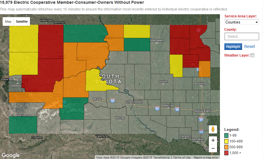
Map below as of 8:55 pm on Monday, December 26th. *NOTE: This is not a comprehensive power outage map and only reflects customers from the SDREA. Therefore, there were more than the listed 15,979 without power across South Dakota, such as across Sully, Potter, and Hughes counties.
Map below as of 7:30 pm on Thursday, December 29th. *NOTE: This is not a comprehensive power outage map and only reflects customers from the SDREA. Therefore, there were more than the listed 6,187 without power across South Dakota, such as across Sully, Potter, and Hughes counties.

Rain & Liquid Equivalent
Precipitation amounts were very impressive for late December, as the system had possibly record levels of atmospheric moisture to work with. Rain or freezing rain was the predominant precipitation type for those roughly east of the Missouri River on the 25th. Daily precipitation records were smashed on the 25th for Mobridge with 1.52" (0.23" in 2009), Pierre with 0.92" (0.48" in 2009), Aberdeen with 1.28" (0.36" in 1950), and Sisseton with 0.7" (0.24" in 1942). Incredibly, Aberdeen and Mobridge also broke records for the wettest December day on record (1.00" on 12-26 in 1916 in Aberdeen, 0.87" on 12-30 in 1931 in Mobridge). Pierre recorded their 2nd wettest December day on record, Kennebec 7th with 0.57" and Timber Lake 8th with 0.73" (also daily records). Finally, Mobridge also broke their record for the wettest winter day (Dec-Feb) on record (1.50" on 2-24 in 1930). Aberdeen had their 3rd wettest winter day on record, and Pierre their 7th. A truly remarkable amount of moisture for a winter storm system.
As a result, in Aberdeen, this heavy rainfall combined with melting snow and ice to produce flooding across several streets. Thunderstorms were also widely reported across the area on the 25th... another incredible aspect to this storm system. For some it was thundersnow, for others lightning was observed while heavy rain fell. Our COOP observer from Pollock reported thundersnow around 9 pm, when at least 4 flashes occurred. A couple strikes appeared to strike the ground.
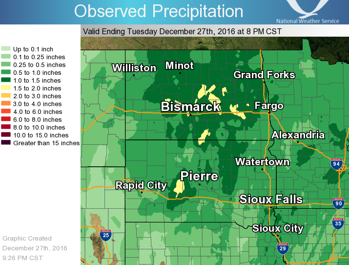 Precipitation Accumulation Map (Click to Enlarge) |
| Report Time | County | Location | Event Type | Mag. | Source | Remark |
| 12/25/16 17:40 | BROWN | ABERDEEN | FLASH FLOOD | 0.00 | PUBLIC | SOME BASEMENTS FLOODING IN ABERDEEN. |
| 12/25/16 18:06 | BROWN | ABERDEEN | FLASH FLOOD | 0.00 | LAW ENFORCEMENT | LAW ENFORCEMENT REPORTS SIGNIFICANT FLOODING OVER SEVERAL MAJOR INTERSECTIONS. |
...24 Hour Precipitation Reports...

Location                     Amount    Time/Date
Mobridge Muni AP             1.52 in   1201 AM 12/26
Westport 2 NW                1.48 in   0900 AM 12/26
Aberdeen 7 NNW               1.36 in   0145 AM 12/26
Aberdeen Rgnl AP             1.28 in   0553 AM 12/26
Aberdeen 1 NNE               1.25 in   0700 AM 12/26
Aberdeen 0.5 SE              1.23 in   0233 AM 12/26
Pierre 11 NNE                1.15 in   0800 AM 12/26
Frederick 9 W                1.14 in   1030 AM 12/26
Pierre 1 SW                  1.14 in   0243 AM 12/26
Victor 4 NNE                 1.13 in   0700 AM 12/26
Fort Pierre                  1.11 in   0700 AM 12/26
Aberdeen 7 W                 1.04 in   0239 AM 12/26
Ashton                       0.97 in   1031 AM 12/26
Pierre Muni AP               0.95 in   0553 AM 12/26
Danforth 5 E                 0.89 in   0541 AM 12/26
Gann Valley 7 WNW            0.83 in   0700 AM 12/26
Browns Valley                0.82 in   0500 AM 12/26
Fort Pierre 2 S              0.82 in   1030 AM 12/26
Browns Valley 6 N            0.81 in   0700 AM 12/26
Sisseton 3 W                 0.79 in   0700 AM 12/26
Leola 9 W                    0.78 in   0205 AM 12/26
Sisseton                     0.77 in   0700 AM 12/26
Hayti 1 W                    0.76 in   0800 AM 12/26
Watertown Muni AP            0.75 in   0553 AM 12/26
Sisseton Muni AP             0.75 in   0556 AM 12/26
Webster                      0.75 in   0905 AM 12/26
Aberdeen 9 NW                0.71 in   0237 AM 12/26
Watertown 2 E                0.71 in   0810 AM 12/26
Lees Corner 8 E              0.70 in   0240 AM 12/26
Wheaton 7 WSW                0.69 in   1000 AM 12/26
Clear Lake                   0.67 in   0931 AM 12/26
Watertown  2 S               0.62 in   0800 AM 12/26
Harrold 4 ESE                0.61 in   0800 AM 12/26
Reliance 4 ENE               0.60 in   0500 AM 12/26
Vivian 12 N                  0.57 in   0159 AM 12/26
Kennebec 0.5 SE              0.57 in   0700 AM 12/26
Big Stone City 1 WNW         0.55 in   0145 AM 12/26
Barnard 5 W                  0.53 in   0231 AM 12/26
Watertown 2 NNE              0.53 in   0715 AM 12/26
Groton                       0.51 in   0234 AM 12/26
Lake City 3 SW               0.50 in   0700 AM 12/26
Vivian 7 NNE                 0.49 in   0700 AM 12/26
Odessa 1 W                   0.49 in   0151 AM 12/26
Milbank                      0.49 in   0730 AM 12/26
Oacoma 9 WSW                 0.49 in   1015 AM 12/26
Wheaton                      0.49 in   0800 AM 12/26
Presho                       0.46 in   0700 AM 12/26
Peever 3 E                   0.46 in   1218 AM 12/26
Wheaton 1 NNE                0.44 in   0830 AM 12/26
Claremont 2 SSE              0.44 in   0700 AM 12/26
Loyalton 5 NE                0.43 in   0245 AM 12/26
Wheaton 1 NW                 0.42 in   1000 AM 12/26
 |
Media use of NWS Web News Stories is encouraged! Please acknowledge the NWS as the source of any news information accessed from this site. |
|

