
A cold front will cross the Great Lakes and Northeast U.S. through Monday with gusty winds and areas of rain showers. A strong atmospheric river is expected to move into the Pacific Northwest by midweek bringing a threat for moderate to heavy rainfall, gusty winds, and mountain snows for parts of Washington, Oregon, northern California, and the Sierra Nevada. Read More >
Overview
|
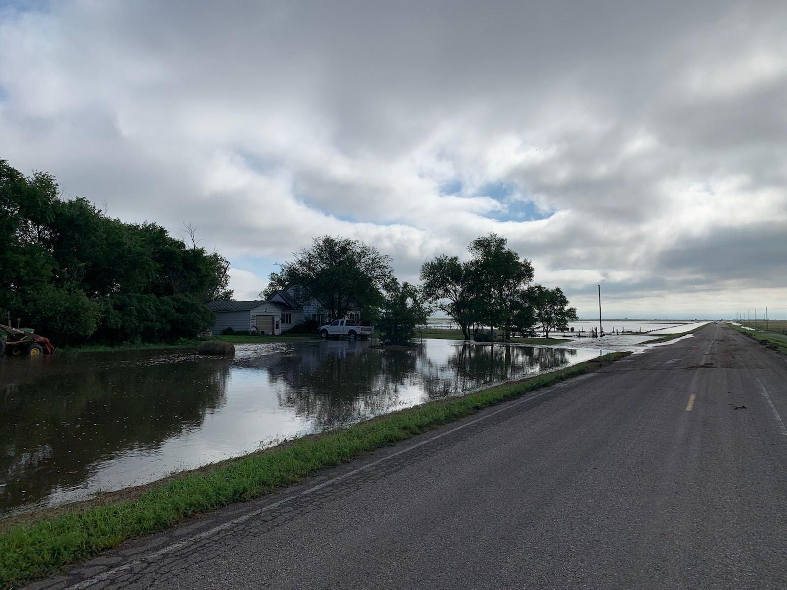
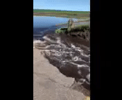
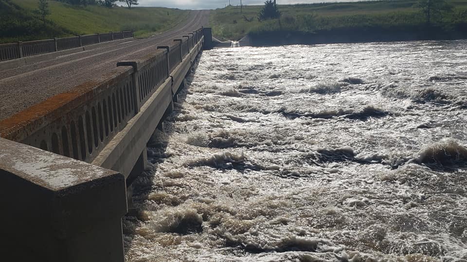
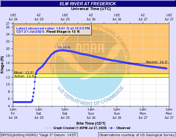
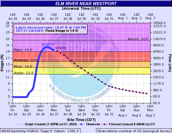
Storms tracked across north central and northeast South Dakota during the evening hours of July 24th and into July 25th. Developing in a very moisture rich atmosphere, the storms were able to produce very heavy rain in a short amount of time, especially over parts of northeastern McPherson County, northern Brown County and far northern Marshall County. Rainfall amounts ranged from 4 to 10 inches, with localized heavier amounts reported. The heavy rain lead to significant overland flooding as well as flooding on Elm Lake and subsequent flooding downstream along the Elm River. Many roads were underwater or completely washed out. There were reports of boats and docks submerged with others freely floating on Elm Lake. The river gauge on the Elm River, just below Elm Lake, (ERFS2) reached a record stage of 19.56 feet by the afternoon of July 25th. The Elm River at Westport (WESS2) crested at a major flood stage of 20.45 feet late on July 26th. |
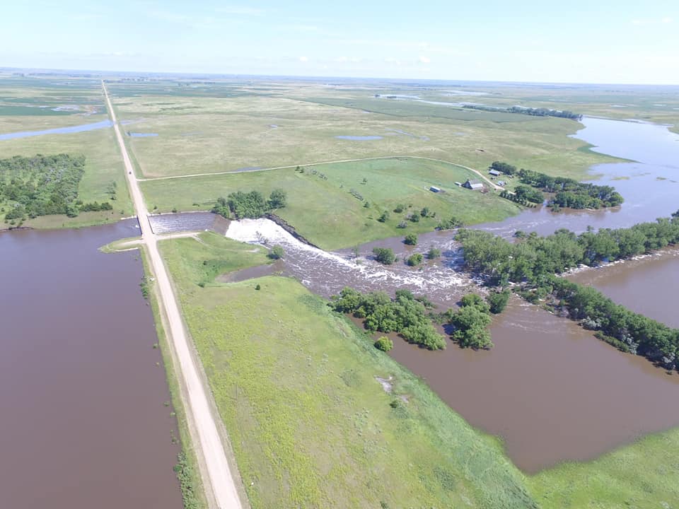 Drone Photo of the Elm Lake Spillway. Photo Credit: Frederick Fire Department |
 |
 |
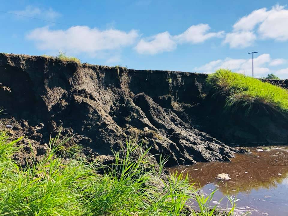 |
| Overland Flooding in NE McPherson County. Photo Credit: McPherson County Emergency Management. | McPherson County Highway 23 Washout. Video Credit: McPherson County Emergency Management. | Road Damage Near Elm Lake. Photo Credit: Elm Lake Association |
 |
 |
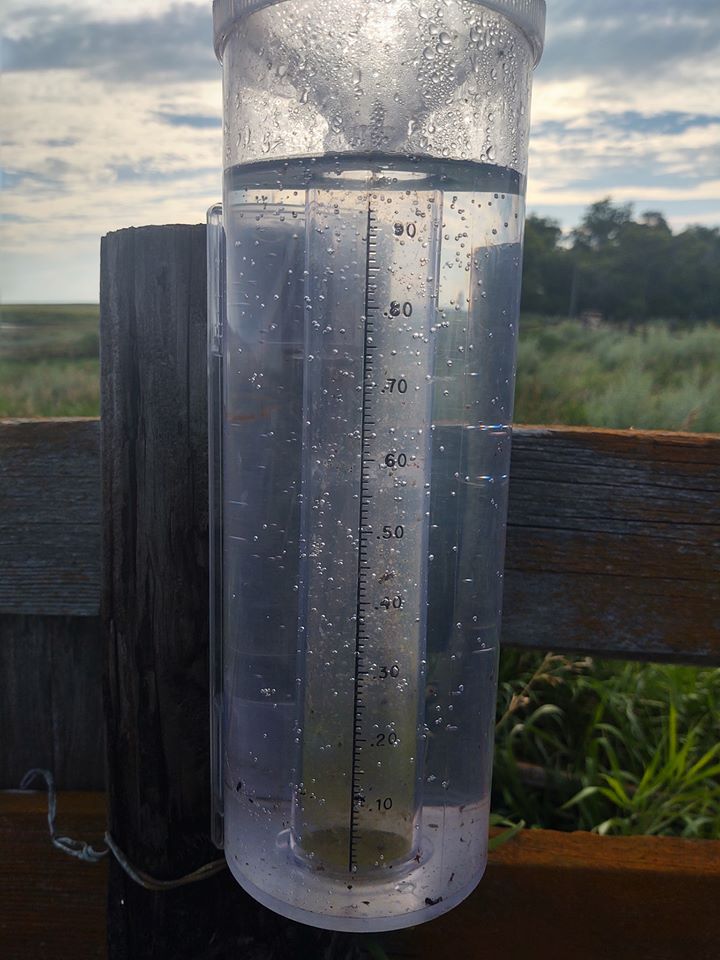 |
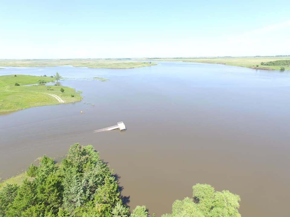
| Water To the Bottom of a Bridge At Elm Lake. Photo Credit: Frederick Fire Department | Drone Photo of the South End of Elm Lake, Spillway to the Left. Photo Credit: Frederick Fire Department. | Full Rain Gauge (10+ inches) 2 Miles West of Elm Lake. Photo Credit of Steffanie Mohror. |
Flooding
Hydrographs
 |
 |
 |
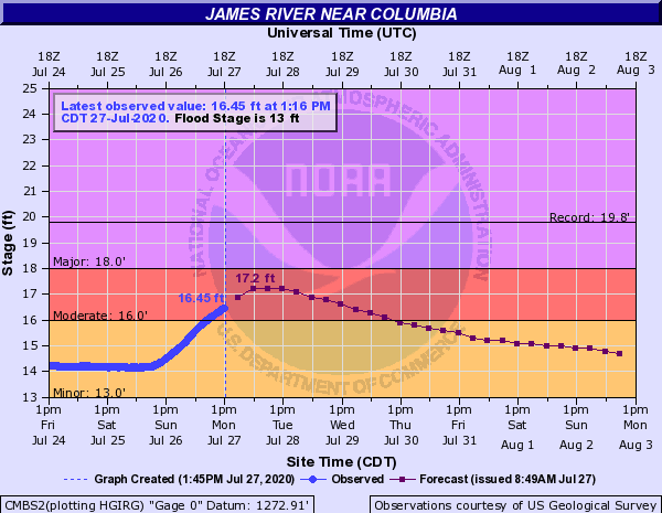 |
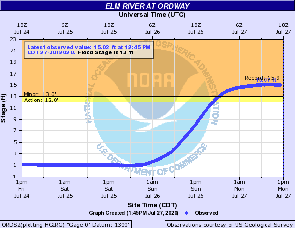
| Elm River Below Elm Lake Hydrograph (ERFS2) | Elm River At Westport Hydrograph (WESS2) | Elm River at Ordway Hydrograph (ORDS2) | James River At Columbia Hydrograph (CMBS2) |
Radar/Photos
 |
 |
 |
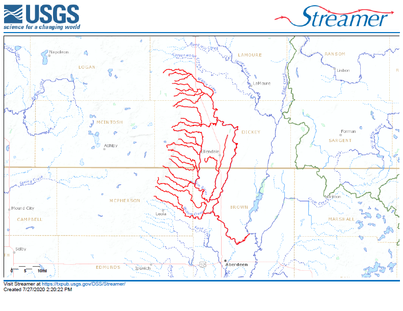 |
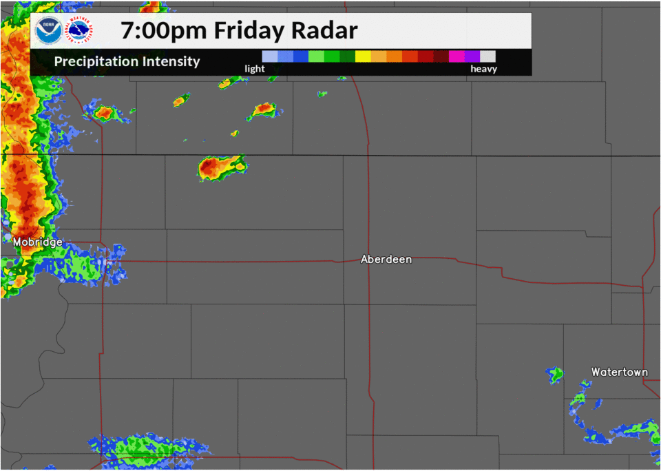
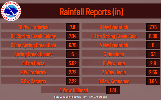
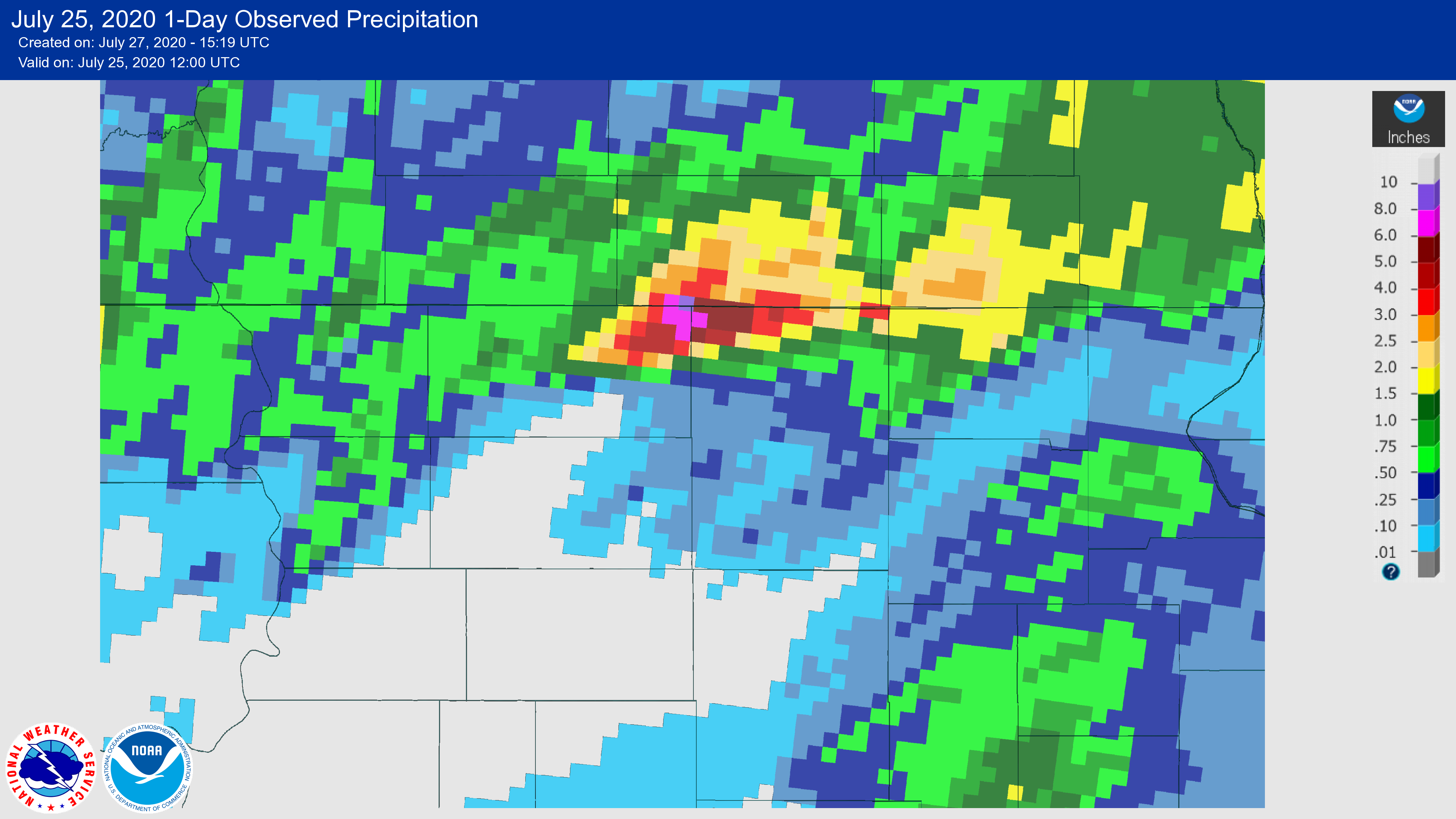
| Radar Loop 7:00 pm CDT July 24, 2020 to 1:00 AM CDT July 25, 2020. | Preliminary Rainfall Reports | Radar Estimates and Rainfall Observations | Map of Streams and Tributaries That Flow Into the Elm River |
Storm Reports
PRELIMINARY LOCAL STORM REPORT...SUMMARY
NATIONAL WEATHER SERVICE ABERDEEN SD
136 PM CDT SAT JUL 25 2020

..TIME...   ...EVENT...      ...CITY LOCATION...     ...LAT.LON...
..DATE...   ....MAG....      ..COUNTY LOCATION..ST.. ...SOURCE....
            ..REMARKS..

1154 PM     TSTM WND GST     9 E SPRING CREEK COLONY 45.91N 98.69W
07/24/2020  M59 MPH          BROWN              SD   MESONET

            PERSONAL WEATHER STATION.

1019 PM     TSTM WND GST     9 E SPRING CREEK COLONY 45.91N 98.69W
07/24/2020  M54 MPH          BROWN              SD   MESONET

            PERSONAL WEATHER STATION PEAK GUST.

0724 PM     TSTM WND GST     2 N HERREID             45.87N 100.07W
07/24/2020  M54 MPH          CAMPBELL           SD   MESONET

            MESONET STATION 50 HERREID (SDDOT).

1020 PM     TSTM WND GST     7 N FREDERICK           45.93N 98.53W
07/24/2020  M53 MPH          BROWN              SD   MESONET

            PEAK GUST.

0722 PM     TSTM WND GST     5 SW KENNEBEC           43.86N 99.93W
07/24/2020  M53 MPH          LYMAN              SD   PUBLIC

            1.95 INCHES OF RAIN AND GUSTS MEASURED VIA
            PERSONAL WEATHER STATION.

0900 AM     HEAVY RAIN       10 NW FREDERICK         45.91N 98.67W
07/25/2020  M7.80 INCH       BROWN              SD   PUBLIC

            STORM TOTAL RAINFALL. 12 HOUR REPORT.

0830 AM     HEAVY RAIN       9 NW FREDERICK          45.92N 98.64W
07/25/2020  M7.75 INCH       BROWN              SD   PUBLIC

            STORM TOTAL RAINFALL.

1240 AM     HEAVY RAIN       9 E SPRING CREEK COLONY 45.91N 98.69W
07/25/2020  M7.04 INCH       BROWN              SD   MESONET

            PERSONAL WEATHER STATION STORM TOTAL
            RAINFALL.

1240 AM     HEAVY RAIN       2 ENE SPRING CREEK COLO 45.92N 98.85W
07/25/2020  M6.86 INCH       MCPHERSON          SD   MESONET

            PERSONAL WEATHER STATION STORM TOTAL
            RAINFALL.

0800 AM     HEAVY RAIN       6 ENE SPRING CREEK COLO 45.93N 98.76W
07/25/2020  M6.75 INCH       MCPHERSON          SD   CO-OP OBSERVER

            ROADS TO THE SOUTH FLOODED FOR THE FIRST
            TIME EVER SINCE THE OBSERVER HAS BEEN THERE.

0833 AM     HEAVY RAIN       4 NW FREDERICK          45.87N 98.57W
07/25/2020  M6.00 INCH       BROWN              SD   PUBLIC

            12 HOUR RAINFALL.

1205 AM     HEAVY RAIN       SPRING CREEK COLONY     45.91N 98.88W
07/25/2020  E6.00 INCH       MCPHERSON          SD   PUBLIC


1100 PM     HEAVY RAIN       2 ENE SPRING CREEK COLO 45.92N 98.85W
07/24/2020  M5.00 INCH       MCPHERSON          SD   MESONET

            STILL RAINING. PERSONAL WEATHER STATION.

1110 PM     HEAVY RAIN       9 E SPRING CREEK COLONY 45.91N 98.69W
07/24/2020  M3.21 INCH       BROWN              SD   PUBLIC

            STILL RAINING. PERSONAL WEATHER STATION.

0700 AM     HEAVY RAIN       3 NNE IONA              43.58N 99.39W
07/25/2020  M3.10 INCH       LYMAN              SD   COCORAHS

            COCORAHS STATION SD-LY-31 IONA 2 NE.

0700 AM     HEAVY RAIN       8 ENE HECLA             45.92N 98.00W
07/25/2020  M3.02 INCH       BROWN              SD   CO-OP OBSERVER

            CO-OP OBSERVER STATION BRTS2 HECLA 5 NE.

0700 AM     HEAVY RAIN       8 WNW IONA              43.59N 99.57W
07/25/2020  M2.90 INCH       LYMAN              SD   COCORAHS

            COCORAHS STATION SD-LY-7 OACOMA 17 SSW.

0700 AM     HEAVY RAIN       9 W FREDERICK           45.84N 98.70W
07/25/2020  M2.72 INCH       BROWN              SD   CO-OP OBSERVER

            CO-OP OBSERVER STATION ERFS2 8.3 SE FORBES.

0700 AM     HEAVY RAIN       7 WNW HECLA             45.92N 98.29W
07/25/2020  M2.55 INCH       BROWN              SD   COCORAHS

            COCORAHS STATION SD-BR-4 HECLA 7 WNW.

0700 AM     HEAVY RAIN       6 SW OACOMA             43.75N 99.48W
07/25/2020  M2.22 INCH       LYMAN              SD   COCORAHS

            COCORAHS STATION SD-LY-15 OACOMA 5 WSW.

0700 AM     HEAVY RAIN       8 SSW KENNEBEC          43.79N 99.92W
07/25/2020  M1.84 INCH       LYMAN              SD   COCORAHS

            COCORAHS STATION SD-LY-27 KENNEBEC 8 SSW.

0700 AM     HEAVY RAIN       4 WNW HILLHEAD          45.86N 97.46W
07/25/2020  M1.81 INCH       MARSHALL           SD   COCORAHS

            COCORAHS STATION SD-MR-10 VEBLEN 8 W.

1015 AM     FLOOD            9 W FREDERICK           45.84N 98.70W
07/25/2020                   BROWN              SD   FIRE DEPT/RESCUE

            MULTIPLE ROADS IN NORTHWESTERN BROWN COUNTY
            WITH WATER OVER THEM. BROWN COUNTY5 107TH IS
            CLOSED WEST OF 378TH AVENUE.

0820 AM     FLOOD            9 E SPRING CREEK COLONY 45.90N 98.69W
07/25/2020                   BROWN              SD   EMERGENCY MNGR

            DOCKS AND PONTOONS FLOATING DUE TO HIGH
            WATER LEVEL ON ELM LAKE. MULTIPLE ROADS
            UNDER WATER.

0310 AM     FLASH FLOOD      7 SE SPRING CREEK COLON 45.84N 98.77W
07/25/2020                   MCPHERSON          SD   EMERGENCY MNGR

            EMERGENCY MANAGER REPORTS MANY COUNTY ROADS
            UNDER WATER. COUNTY ROAD 23 (371ST AVE), IN
            PARTICULAR, HAS AN AREA VERY DEEP UNDER
            WATER. NO TRAVEL ADVISED IN NORTHEAST
            MCPHERSON COUNTY EARLY THIS MORNING!.
 |
Media use of NWS Web News Stories is encouraged! Please acknowledge the NWS as the source of any news information accessed from this site. |
|

