Weather History - February 28
Local and Regional Events:
February 28, 2007:
Another late February low-pressure system crossed the central plains and spread heavy snow 6 to 11 inches across northeast South Dakota and west-central Minnesota. As a result, many schools and college classes were, canceled, and many events were postponed. In addition, road conditions became deplorable, with some accidents occurring along with ditched vehicles. The snow continued into the first day of March and ended in the morning. Snowfall amounts included 6 inches at Aberdeen, 7 inches at Wilmot and Artichoke Lake, 8 inches at Conde, Watertown, Milbank, 9 inches at Browns Valley and Wheaton, and 11 inches at Clark. This heavy snow event was followed by more snowfall and blizzard conditions that developed across the area during the afternoon and evening of March 01.
U.S.A and Global Events for February 28:
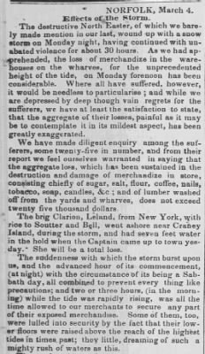
1846: William S. Forrest, in "Historical and Descriptive Sketches of Norfolk and Vicinity" in 1853, recorded the Great Gust of 1846. The Great Gust was a severe coastal storm that produced 5 feet waves in Norfolk. You can read his account of the storm by clicking HERE. The storm is at the bottom of pages 225 to 226.
1900: A massive storm produced record snow from Kansas to northwest Ohio and southern Michigan from February 27 to March 01. The observation at the University of Kansas in Lawrence reported 15 inches of snow on the 27th was "phenomenal; only one heavier snowfall has been recorded for any month, a depth of 16 inches on February 11th and 12th, 1894." (CD). The Coop near Wamego, KS, in the northeast part of Kansas, a record-breaking 24 inches fell in just 12 hours! Other snowfall amounts in Kansas include 19.0" in Abilene, 18.7" in Topeka, 18.0" in McPherson, and 18.0" in Ellinwood. Topeka saw 17.3" on February 27, the most recorded in 24 hours.
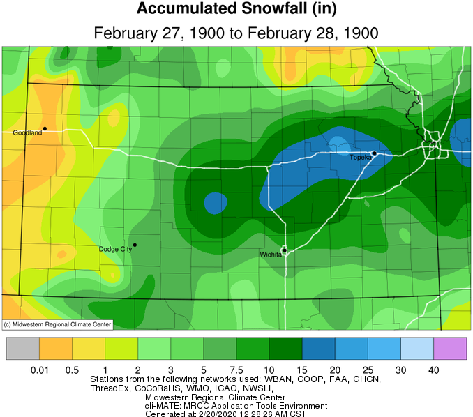
In Missouri, heavy snow fell over a considerable portion of the state on the 27th and 28th. From Bates, Cass, Jackson, and Platte counties in the west, to St. Charles, Lincoln, Pike, Ralls, Marion, Lewis, and Clark counties to the east, snowfall ranged from 10 to over 20 inches. The snow drifted severely in many places, and where the fall of snow exceeded 10 inches, railroads were blocked, and county roads rendered impassable for several days. A Coop in Darksville, in northern Randolph County, reported drifts from 6 to 8 feet deep in many places. Houstonia Pettis County's drifts were the worst for more than 30 years. Snowfall amounts in Missouri include 22" in Miami, 20" in Richmond, 13.9" in Columbia, and 13" in Kansas City and Jefferson City.
The storm probably gave central and northern parts of Illinois some of the highest snowfall totals since 1830-1831. (CD) The Coop in Astoria measured an astonishing 37.8 inches with this storm! Coatsburg saw 26 inches. Other snowfall amounts include 21" near Normal, 17.5" in Springfield, and 13" near Jacksonville.
Heavy snow, freezing rain, and sleet occurred in Indiana from February 28 to March 01. In South Bend, 16" of snow fell, prompting street-car employees to work all night to keep the tracks open. As a result, railroad traffic was delayed on all lines. Fairmount and Greensburg reported ice and sleet covered the ground on the 28th. Marion, in Grant County, observed the heaviest sleet storm in many years. Some snowfall amounts include 21" at Valparaiso Waterworks, 18" in Syracuse, Angola, and Fort Wayne, and 16" in South Bend and Huntington.
Northwestern Ohio and southern Michigan saw heavy snowfall from February 27 to March 01. The Coop in Wauseon Water Plant recorded 20.5" of snow. Toledo received 20.2 inches. Grape, Michigan, west-northwest of Monroe, said the heavy snow made all roads impassable. Mail could not be delivered from Grape to Monroe due to badly drifted snow. Some snowfall amounts from southern Michigan include 18" in Hillsdale, Grape, and Somerset, 14" in Detroit, 13" in Lancing, and 12" in Kalamazoo.
1952: A powerful Nor'easter hit Cape Cod with winds of 70-80 mph and snowfall amounts of 12-20 inches. These conditions created 12 feet drifts.
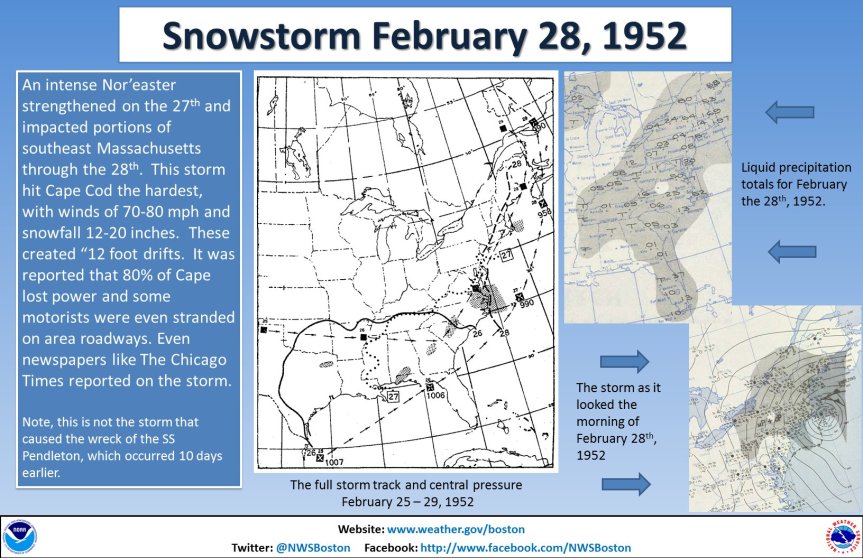
The image above is from a tweet by the NWS Office in Boston, Massachusetts.
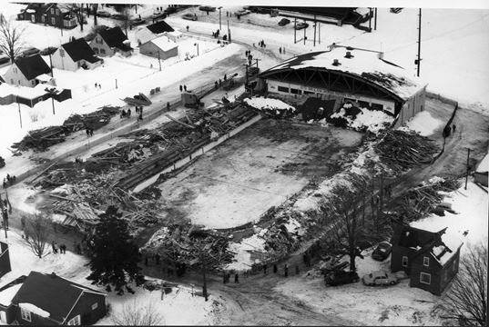
1959: In early December 1958, temperatures fell below freezing and remained there until late February. Over 49 inches of snow fell in that time, with very little in the way of melting. The snow absorbed some rain in February and added to the weight on the roof of the Listowel Arena in Ontario, Canada. As a result, the roof collapsed on February 28, 1959, during a hockey game. Seven young players, a referee, and a recreation director (Reginald Kenneth McLeod) were killed in the tragic collapse. Click HERE for more information.
1962: Wilmington, North Carolina, reached a high temperature of 85 degrees. This is the warmest temperature on record during February.
2007: A severe storm named Xynthia blows into France, Portugal, and Spain, smashing sea walls, destroying homes, polluting farmland with salt water, and devastating the Atlantic coast's oyster farms. Winds reach about 125 mph on the summits of the Pyrenees and up to nearly 100 mph along the Atlantic Coast. Wind speeds of 106 mph are measured atop the Eiffel Tower in Paris. The hardest-hit area was in the Vendee and Charente-Maritime regions in southwestern France. The storm is blamed for 52 deaths in France. In addition, a Napoleonic sea wall collapsed off the coastal town of La'Aiguillon-Sur-Mer. A mobile home park close to the sea wall was particularly hard hit. Click HERE for more information from the BBC.
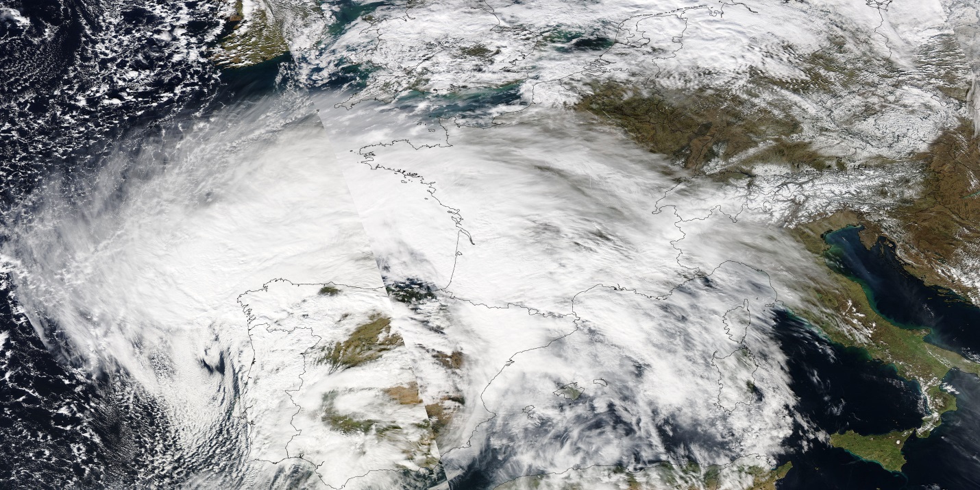
The image above is courtesy of NASA's Earth Observatory.
2018: A waterspout was seen off the coast of Brixham, in southwestern England. Click HERE for more information.
Click HERE for more This Day in Weather History from the Southeast Regional Climate Center.