The first multiple tornado outbreak of 2017 in the Central Savannah River Area (CSRA) and the South Carolina (SC) Midlands occurred on Saturday, January 21. Three tornadoes occurred during the afternoon hours. One in Burke County, GA near Waynesboro (EF1), one in northeast Barnwell and northwest Bamberg Counties, SC (EF2), and one in Orangeburg County, SC (EF1). Full descriptions are at the end of the review. All of these tornadoes were spawned by the same thunderstorm complex.
The overall pattern during the afternoon of January 21 was favorable for tornadoes. At 1 PM EST (18Z), a strong low level jet could be seen in the 850 mb chart in southern Georgia, with maximum values of 55 knots. These strong winds contributed to large amounts of low level shear, one of the necessary ingredients for tornadoes.
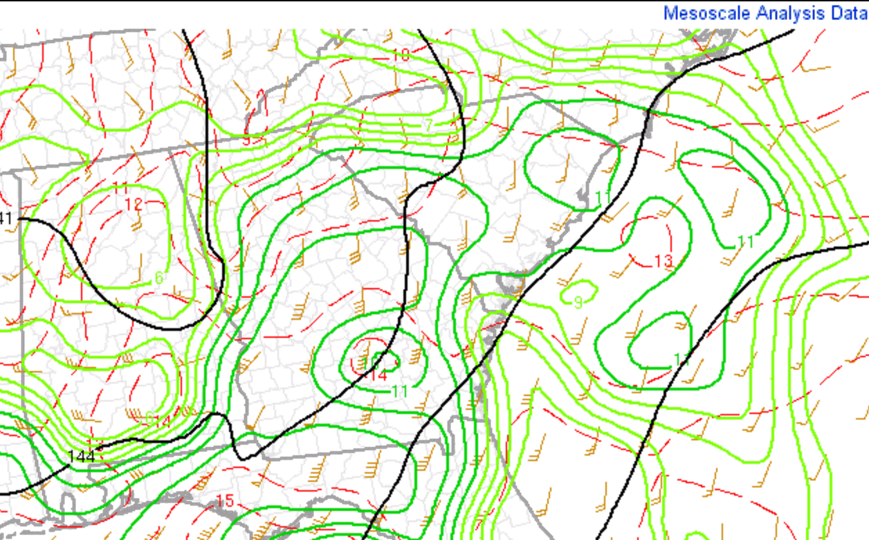
January 21, 2017, 850 mb geopotential height, temperature (C), dewpoint (C), and wind (Mesoanalysis from Storm Prediction Center)
Meanwhile, at 500 mb, a strong mid-level jet maximum of 65 knots was moving into the CSRA and southern SC Midlands.

January 21, 2017, 1 PM EST 500 mb geopotential height, temperature (C), and wind (Mesoanalysis from Storm Prediction Center)
At the surface, a warm front extended across the CSRA and Midlands. This was the focus for the strongest convection for the afternoon due to the enhanced surface convergence near the front.
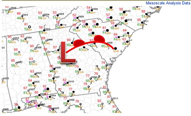
January 21, 2017, 1 PM EST surface observations (Mesoanalysis from Storm Prediction Center)
South of the warm front, the air mass was more unstable, as can be seen in the 1 PM surface—based Convective Available Potential Energy (CAPE). The strong low level winds mentioned above were driving this unstable air mass into the region of the warm front.

January 21, 2017, 1 PM EST surface-based Convective Available Potential Energy (Mesoanalysis from Storm Prediction Center)
The combination of strong low level winds and instability lead to a local “bullseye” of effective wind shear, heading right toward the location of the warm front, where the tornadoes eventually formed.
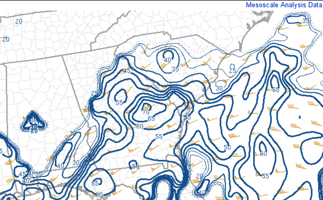
January 21, 2017, 1 PM EST effective Bulk Shear (Mesoanalysis from Storm Prediction Center)
At 1 PM, the radar composite clearly showed a well-organized MCS in Georgia, along with some showers and a few thunderstorms to the north of the warm front in the northern half of South Carolina. The cooling that occurred as a result of those showers held the warm front in the southern CSRA and southern SC Midlands for the remainder of the afternoon as the squall line was moving in from the west.

January 21, 2017, 1 PM EST composite radar (Mesoanalysis from Storm Prediction Center)
Over the next 2 ½ to 3 hours, an organized mesocyclone moved directly across the southern CSRA and southern SC Midlands, spawning the 3 tornadoes.

This reflectivity loop above from the Columbia, SC WSR-88D Doppler Radar (KCAE) shows a long lived mesoscale complex moving into Burke County
around 2:20 PM EST (1920Z), then moving east northeastward across Barnwell, Bamberg, and Orangeburg Counties. Of particular note is the appendage
near Waynesboro at the time of tornado 1. The appendage becomes a little less distinct in eastern Burke County, but becomes more obvious again once it
approaches Barnwell. Notice also you can see small features being pulled northwestward toward the area of the appendage in the inflow portion of the
mesocyclone. This is an indication that the cyclonic rotation is reasonably strong.

The storm-relative velocity loop above from KCAE shows how the Doppler velocities evolved during the path of the mesocyclone. While there are clearly some strong velocities and shear moving into Burke County after 2 PM EST (19Z), the velocities fall victim to a phenomena known as range folding (the band of deep purple you see on the loop). Fortunately, there are ways to mitigate range folding, and you can see the purple band moves away from the area of interest at 2:46 PM, showing the characteristic red and green velocity signature of a mesocyclone.
The times when the circulation appears the tightest through the loop corresponds well with times of tornado damage on the ground in Barnwell, Bamberg, and Orangeburg Counties. The circulation on radar becomes very tight and strong southwest of Blackville at 3:46 PM (2046Z), right before the touchdown of tornado 2. After passing by Blackville, it weakens slightly as it passes north of Denmark. The circulation tightens again when approaching Cope in Orangeburg County at 4:09 PM (2109Z).
To help with some of the range folding issues mentioned above, we are also able to investigate thunderstorms using other radars from surrounding locations. In this case, the WSR-88D Doppler radar from Warner Robbins, Georgia (KJGX), also had a good angle to sample the storm. The loops from KGJX are shown next.


From these loops, you can see that there are some similarities in the radar structure of the thunderstorms complex, but there are also some differences. These differences arise because they are not always sampling the same part of the thunderstorm. For example, as the storm moves from Burke into Barnwell, Bamberg, and Orangeburg Counties, it is moving gradually closer to the Columbia radar (KCAE), but moving further away from the Warner Robbins radar (KJGX). Once it reaches Cope, SC, for example, the lowest elevation scan from KCAE is sampling the storm at around 2900 feet above ground level, while KJGX is sampling the same storm at about 17,000 feet. These are considerations the NWS warning forecasters need to keep in mind when looking at multiple radars for a given thunderstorm.
To put the outbreak in perspective, we want to look at the frequency of tornadoes in the month of January going back to 1950, the period which we have reliable records of tornadoes. Multiple tornadoes in a single day in January are a rare occurrence in SC. It has only happened 7 other times since 1950. Additionally, there have only been three EF2 tornadoes in the month of January since 1950. One in Florence County on January 8, 1953, one in Pickens County on January 7, 1998, and one in Laurens County on January 13, 2005.

Track map of Tornadoes 2 and 3.

