|
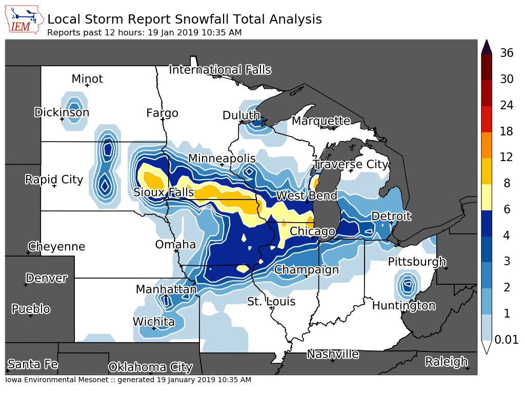
A significant winter storm system brought accumulating snow and hazardous travel conditions to the region Friday afternoon (Jan. 18) through much of the day Saturday (Jan. 19). Total snowfall accumulations of 3 to 6 inches fell across the area, with the higher amounts of 7 to 9 inches in the Freeport, IL and Memphis, MO areas. In addition, strong winds resulted in some blowing and drifting snow and hazardous travel conditions.
|
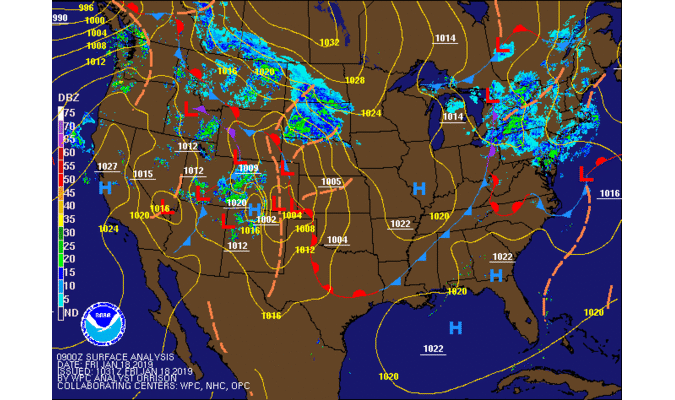 Surface Maps |
||||
Snowfall Maps
| Regional Snowfall January 19th, 2019 |
Local Snowfall January 19th, 2019 |
 |
 |
| Courtesy: IEM | |
 |
| Courtesy: Iowa Environmental Mesonet |
PUBLIC INFORMATION STATEMENT
NATIONAL WEATHER SERVICE QUAD CITIES IA IL
1030 AM CST SAT JAN 19 2019

...SNOWFALL REPORTS...

SNOW REPORTS LISTED BY AMOUNT

 INCHES  LOCATION                 ST  COUNTY           TIME
 ------  -----------------------  --  --------------   -------
  9.0    FREEPORT                 IL  STEPHENSON       0841 AM
  8.0    1 WSW MEMPHIS            MO  SCOTLAND         0617 AM
  7.2    SHANNON                  IL  CARROLL          0947 AM
  7.0    3 W AZEN                 MO  SCOTLAND         0906 AM
  7.0    1 ENE BURLINGTON REGION  IA  DES MOINES       0825 AM
  6.8    2 NE CALAMUS             IA  CLINTON          0700 AM
  6.5    4 W BERTRAM              IA  LINN             0958 AM
  6.5    4 S CRAWFORD             MO  SCOTLAND         0909 AM
  6.3    INDEPENDENCE             IA  BUCHANAN         0825 AM
  6.2    ROCK FALLS               IL  WHITESIDE        0750 AM
  6.2    COGGON                   IA  LINN             0500 AM
  6.1    GALENA                   IL  JO DAVIESS       0813 AM
  6.1    1 ENE KEWANEE            IL  HENRY            0700 AM
  6.0    2 NNE STONE CITY         IA  JONES            1005 AM
  6.0    3 SW WINNESHIEK          IL  STEPHENSON       1004 AM
  6.0    1 NE OAKDALE             IA  JOHNSON          1003 AM
  6.0    1 W CAMBRIDGE            IL  HENRY            0945 AM
  6.0    HOPKINTON                IA  DELAWARE         0933 AM
  6.0    IOWA CITY                IA  JOHNSON          0904 AM
  6.0    3 S URBANA               IA  BENTON           0904 AM
  6.0    1 NNW MONTICELLO         IA  JONES            0854 AM
  6.0    2 N BURLINGTON           IA  DES MOINES       0755 AM
  6.0    2 NW FREEPORT            IL  STEPHENSON       0700 AM
  6.0    2 SE COAL VALLEY         IL  HENRY            0700 AM
  6.0    2 WNW FREEPORT           IL  STEPHENSON       0649 AM
  5.8    CAMBRIDGE                IL  HENRY            0715 AM
  5.8    PARNELL                  IA  IOWA             0659 AM
  5.8    NORA                     IL  JO DAVIESS       0452 AM
  5.6    DUBUQUE AIRPORT          IA  DUBUQUE          0600 AM
  5.5    1 W COU FALLS            IA  JOHNSON          0959 AM
  5.5    4 N STOCKTON             IL  JO DAVIESS       0923 AM
  5.5    1 WNW MORRISON           IL  WHITESIDE        0859 AM
  5.5    1 SSW MOOAR              IA  LEE              0839 AM
  5.5    1 W ELMIRA               IA  JOHNSON          0637 AM
  5.5    2 N CREDIT ISLAND        IA  SCOTT            0604 AM
  5.4    2 NE CEDAR RAPIDS        IA  LINN             0815 AM
  5.3    DAVENPORT AIRPORT        IA  SCOTT            0600 AM
  5.2    1 NW ELDRIDGE            IA  SCOTT            0800 AM
  5.2    LOWDEN                   IA  CEDAR            0739 AM
  5.1    2 NNW DAVENPORT          IA  SCOTT            0853 AM
  5.0    1 SSW KEWANEE            IL  HENRY            0946 AM
  5.0    FORT MADISON             IA  LEE              0933 AM
  5.0    BELLE PLAINE             IA  BENTON           0924 AM
  5.0    1 E WEST BURLINGTON      IA  DES MOINES       0903 AM
  5.0    UNIVERSITY HEIGHTS       IA  JOHNSON          0844 AM
  5.0    2 NW MARION              IA  LINN             0833 AM
  5.0    3 WNW MOUNT STERLING     IA  VAN BUREN        0833 AM
  5.0    2 SSE HIAWATHA           IA  LINN             0714 AM
  5.0    2 W MAQUOKETA            IA  JACKSON          0700 AM
  4.8    MUSCATINE                IA  MUSCATINE        0952 AM
  4.8    PEARL CITY               IL  STEPHENSON       0852 AM
  4.8    2 WSW HIAWATHA           IA  LINN             0838 AM
  4.8    1 NNE MOLINE             IL  ROCK ISLAND      0700 AM
  4.7    1 SE PRINCETON           IL  BUREAU           0645 AM
  4.6    2 ESE FAIRVIEW           IA  JONES            0700 AM
  4.5    1 SW UNIVERSITY HEIGHTS  IA  JOHNSON          0951 AM
  4.5    BERTRAM                  IA  LINN             0913 AM
  4.5    2 NNW NORTH LIBERTY      IA  JOHNSON          0855 AM
  4.5    1 SE WASHINGTON          IA  WASHINGTON       0831 AM
  4.5    1 ESE NORTH LIBERTY      IA  JOHNSON          0757 AM
  4.5    1 ENE MOUNT VERNON       IA  LINN             0729 AM
  4.5    1 N STERLING             IL  WHITESIDE        0717 AM
  4.5    2 SSW DAVENPORT          IA  SCOTT            0640 AM
  4.5    1 NNW CENTER POINT       IA  LINN             0600 AM
  4.4    1 S WALCOTT              IA  SCOTT            0839 AM
  4.4    2 SSW HIAWATHA           IA  LINN             0445 AM
  4.3    4 SSE LORAN              IL  CARROLL          1021 AM
  4.3    2 SW GALVA               IL  HENRY            0923 AM
  4.2    2 NE COLUSA              IL  HANCOCK          0733 AM
  4.2    MOLINE QUAD-CITY AIRPOR  IL  ROCK ISLAND      0600 AM
  4.1    3 SW CENTER JUNCTION     IA  JONES            0648 AM
  4.1    2 NW ELIZABETH           IL  JO DAVIESS       0630 AM
  4.0    1 NNW MAQUOKETA          IA  JACKSON          0947 AM
  4.0    2 SE ASBURY              IA  DUBUQUE          0942 AM
  4.0    1 WNW MAQUOKETA          IA  JACKSON          0932 AM
  4.0    3 NW DEWITT              IA  CLINTON          0905 AM
  4.0    1 ESE NEW LONDON         IA  HENRY            0854 AM
  4.0    1 SSW NORTH LIBERTY      IA  JOHNSON          0836 AM
  4.0    2 NNE FAIRFIELD          IA  JEFFERSON        0829 AM
  4.0    MOUNT PLEASANT           IA  HENRY            0822 AM
  4.0    CARTHAGE                 IL  HANCOCK          0729 AM
  4.0    2 NNW WILLIAMSTOWN       IA  JOHNSON          0715 AM
  4.0    1 N ALEDO                IL  MERCER           0700 AM
  4.0    KEOSAUQUA                IA  VAN BUREN        0700 AM
  4.0    1 S SALEM                IA  HENRY            0700 AM
  4.0    DUBUQUE                  IA  DUBUQUE          0650 AM
  4.0    1 SW PERLEE              IA  JEFFERSON        0649 AM
  4.0    2 NNE CEDAR RAPIDS       IA  LINN             0445 AM
  3.8    NORTH ENGLISH            IA  IOWA             0948 AM
  3.8    WAPELLO                  IA  LOUISA           0530 AM
  3.8    2 SSE MACOMB             IL  MCDONOUGH        0430 AM
  3.5    1 W ANAMOSA              IA  JONES            0952 AM
  3.5    STANWOOD                 IA  CEDAR            0902 AM
  3.5    1 W WASHINGTON AIRPORT   IA  WASHINGTON       0700 AM
  3.4    1 ENE MONTPELIER         IA  SCOTT            0949 AM
  3.4    3 NE MUSCATINE           IA  MUSCATINE        0626 AM
  3.3    2 ESE FAIRFIELD          IA  JEFFERSON        0856 AM
  3.0    BUSHNELL                 IL  MCDONOUGH        0947 AM
  3.0    1 WNW BETTENDORF         IA  SCOTT            0823 AM
|
Environment
| Mesoscale Discussion #23 658 PM CST January 18th, 2019 |
Davenport Sounding 6 PM CST January 18th, 2019 |
Davenport Sounding 6 AM CST January 19th, 2019 |
 |
 |
 |
|
|
 |
Media use of NWS Web News Stories is encouraged! Please acknowledge the NWS as the source of any news information accessed from this site. |
|


