Overview
|
A winter storm brought snow to the region starting late Friday morning, persisting into the overnight hours. Mostly "light and fluffy", 1" per hour snowfall rates were common. A narrow swath of heavy snow fell across far northern Iowa and southern Minnesota into southwest Wisconsin with 7 to 14 inches occurring in this band. Lower amounts were observed to the north and south of the heavy snow band. |
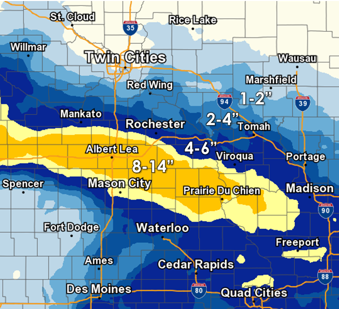 24-hr snowfall ending at 6 am, January 19, 2019 |
Snow/Ice
Location                     Amount    Time/Date       Lat/Lon

...Iowa...

...Allamakee County...
Lansing                      10.0 in   0641 AM 01/19   43.36N/91.22W
4 WNW Lansing                5.3 in    0700 AM 01/19   43.40N/91.29W

...Clayton County...
Monona                       11.0 in   0859 AM 01/19   43.06N/91.39W
Guttenberg                   7.0 in    0818 AM 01/19   42.78N/91.10W
Volga 1NE                    7.0 in    0637 AM 01/19   42.81N/91.52W
Elkader 6SSW                 5.9 in    0700 AM 01/19   42.78N/91.45W

...Fayette County...
West Union                   10.5 in   0918 AM 01/19   42.96N/91.81W
Fayette                      7.0 in    0645 AM 01/19   42.85N/91.82W
Oelwein                      4.6 in    0700 AM 01/19   42.68N/91.91W

...Floyd County...
Charles City Fire Dept       6.2 in    0704 AM 01/19   43.06N/92.67W

...Howard County...
2 N Cresco                   13.0 in   0842 AM 01/19   43.40N/92.12W
Cresco                       10.5 in   0819 AM 01/19   43.38N/92.11W
3 E Mcintire                 10.0 in   0800 AM 01/19   43.44N/92.54W
Lime Springs                 10.0 in   0716 AM 01/19   43.45N/92.28W
Elma                         8.0 in    0700 AM 01/19   43.24N/92.44W

...Mitchell County...
Osage                        10.0 in   0701 AM 01/19   43.28N/92.81W

...Winneshiek County...
4 NNE Bluffton               14.0 in   0715 AM 01/19   43.46N/91.87W
Decorah                      11.8 in   0717 AM 01/19   43.30N/91.79W
Calmar                       11.5 in   0843 AM 01/19   43.18N/91.86W
7 ENE Decorah                11.5 in   0800 AM 01/19   43.34N/91.64W
1 ESE Decorah                11.0 in   0655 AM 01/19   43.30N/91.77W

...Minnesota...

...Dodge County...
2 NE Kasson                  5.0 in    0700 AM 01/19   44.05N/92.72W

...Fillmore County...
Spring Valley                11.0 in   0853 AM 01/19   43.69N/92.38W
Spring Valley 3E             8.6 in    0700 AM 01/19   43.68N/92.33W
Lanesboro 2NE                6.8 in    0745 AM 01/19   43.73N/91.94W
1 SSE Pilot Mound            6.8 in    0700 AM 01/19   43.79N/92.03W
1 ESE Peterson               6.0 in    0712 AM 01/19   43.78N/91.82W
Mabel                        5.6 in    0700 AM 01/19   43.52N/91.76W

...Houston County...
Spring Grove                 11.0 in   0840 AM 01/19   43.56N/91.63W
4 NW Eitzen                  8.0 in    0800 AM 01/19   43.56N/91.51W
3 W Stoddard                 7.4 in    0700 AM 01/19   43.65N/91.28W
2 NE Mound Prairie           4.9 in    0812 AM 01/19   43.80N/91.43W
1 NNW La Crescent            4.9 in    0700 AM 01/19   43.83N/91.31W

...Mower County...
Austin WWTF                  10.2 in   0700 AM 01/19   43.65N/92.97W
4 WSW Austin                 10.0 in   0811 AM 01/19   43.64N/93.05W

...Olmsted County...
5 N Stewartville             8.4 in    0703 AM 01/19   43.93N/92.47W
3 SSW Predmore               7.5 in    0505 AM 01/19   43.90N/92.34W
4 ESE Douglas                5.1 in    0700 AM 01/19   44.08N/92.48W
4 SE Douglas                 5.0 in    0753 AM 01/19   44.07N/92.51W
2 NNW Rochester              5.0 in    0600 AM 01/19   44.05N/92.49W
Rochester                    4.1 in    0835 AM 01/19   44.02N/92.48W
1 SSW Oronoco                4.0 in    1054 AM 01/19   44.15N/92.54W
Elgin 2SSW                   3.6 in    0700 AM 01/19   44.10N/92.27W
2 NE Rochester               3.5 in    0600 AM 01/19   44.04N/92.44W

...Wabasha County...
3 SW Zumbro Falls            4.0 in    0842 AM 01/19   44.24N/92.46W
Theilman 1SSW                3.3 in    0730 AM 01/19   44.28N/92.19W
1 N Wabasha                  2.3 in    0827 AM 01/19   44.38N/92.04W

...Winona County...
Winona 4SW                   5.5 in    0736 AM 01/19   43.98N/91.71W
Altura 5w                    5.0 in    0700 AM 01/19   44.06N/92.04W
Winona Dam 5A                4.0 in    0800 AM 01/19   44.09N/91.67W
La Crescent Dam 7            3.6 in    0800 AM 01/19   43.87N/91.31W
1 E Winona                   3.3 in    0841 AM 01/19   44.05N/91.64W
Minnesota City Dam 5         2.7 in    0800 AM 01/19   44.16N/91.81W

...Wisconsin...

...Adams County...
Friendship                   2.0 in    0700 AM 01/19   43.98N/89.83W
3 ESE New Rome               1.3 in    1055 AM 01/19   44.21N/89.82W

...Buffalo County...
Cochrane                     3.5 in    0100 AM 01/19   44.22N/91.83W
5 NE Montana                 2.5 in    0925 AM 01/19   44.40N/91.61W
Alma Dam 4                   2.0 in    0800 AM 01/19   44.33N/91.92W

...Clark County...
Withee                       0.5 in    0705 AM 01/19   44.96N/90.60W

...Crawford County...
De Soto 1SE                  9.0 in    0700 AM 01/19   43.42N/91.19W
De Soto                      8.0 in    0600 AM 01/19   43.42N/91.20W
Gays Mills                   7.0 in    0700 AM 01/19   43.32N/90.85W
1 WNW Mount Zion             6.0 in    0700 AM 01/19   43.26N/90.76W

...Grant County...
Sinsinawa                    8.0 in    1050 AM 01/19   42.52N/90.54W
Cassville                    7.0 in    0647 AM 01/19   42.72N/90.99W
1 W Platteville              6.0 in    0743 AM 01/19   42.74N/90.49W
Cuba City                    5.4 in    0600 AM 01/19   42.61N/90.43W

...Juneau County...
Mauston 1se                  3.0 in    0800 AM 01/19   43.79N/90.06W

...La Crosse County...
5 SSE La Crosse              4.5 in    0906 AM 01/19   43.75N/91.20W
1 SW Barre Mills             4.3 in    0700 AM 01/19   43.82N/91.13W
French Island                4.1 in    0600 AM 01/19   43.86N/91.27W
2 S Holmen                   4.0 in    0834 AM 01/19   43.93N/91.25W
2 SSE Holmen                 3.9 in    0700 AM 01/19   43.93N/91.24W

...Monroe County...
Melvina                      4.5 in    0700 AM 01/19   43.81N/90.76W
1 S Tomah                    3.5 in    0900 AM 01/19   43.98N/90.50W
Sparta                       3.5 in    0411 AM 01/19   43.94N/90.81W
3 WNW Kendall                3.2 in    0700 AM 01/19   43.81N/90.44W
Cataract                     2.5 in    0700 AM 01/19   44.08N/90.85W

...Richland County...
Gillingham                   5.0 in    0730 AM 01/19   43.43N/90.45W

...Trempealeau County...
Independence 3NE             3.0 in    0337 AM 01/19   44.39N/91.39W
Ettrick 4WNW                 2.8 in    0742 AM 01/19   44.19N/91.34W
Galesville 2wsw              2.8 in    0700 AM 01/19   44.07N/91.39W

...Vernon County...
3 N Victory                  7.0 in    0727 AM 01/19   43.53N/91.22W
2 NE Genoa                   6.5 in    0834 AM 01/19   43.59N/91.21W
La Farge                     6.2 in    0700 AM 01/19   43.57N/90.64W
Genoa Dam 8                  6.0 in    0800 AM 01/19   43.57N/91.23W
Viroqua                      5.8 in    0700 AM 01/19   43.56N/90.88W
Stoddard                     5.4 in    0700 AM 01/19   43.66N/91.22W
2 NE Stoddard                5.3 in    0825 AM 01/19   43.68N/91.18W
Hillsboro WSW                4.8 in    0700 AM 01/19   43.65N/90.35W
Hillsboro 2SW                4.5 in    0700 AM 01/19   43.63N/90.38W
Viroqua 0.8 ESE              2.6 in    0700 AM 01/19   43.55N/90.87W
Westby 3ENE                  2.0 in    0700 AM 01/19   43.67N/90.81W

Observations are collected from a variety of sources with varying
equipment and exposures. We thank all volunteer weather observers
for their dedication. Not all data listed are considered official.
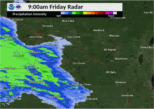
Radar:
 |
|||
| Reflectivity 9 am Friday to 3 am Saturday |
 |
Media use of NWS Web News Stories is encouraged! Please acknowledge the NWS as the source of any news information accessed from this site. |
|


 Weather Story
 Weather Map
 Local Radar