Overview
|
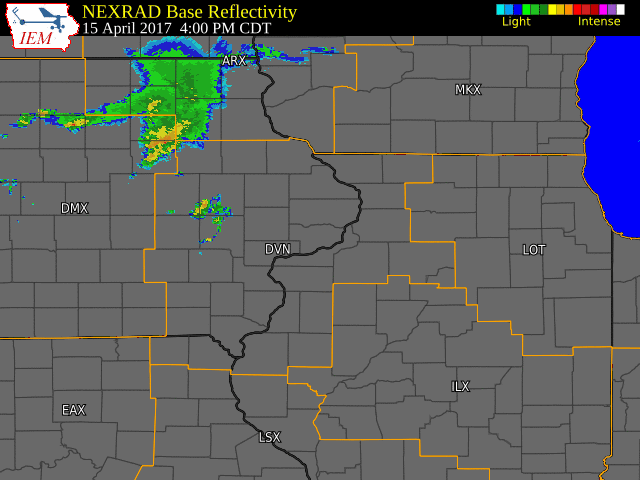
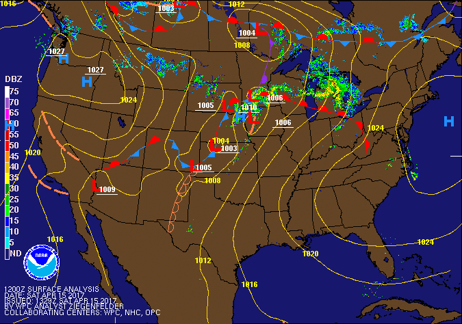
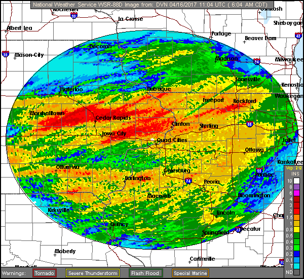
Scattered showers and thunderstorms tracked across portions of eastern Iowa and northern Illinois the evening of April 15, as a cold front pushed east across Iowa. Large hail, heavy downpours, and frequent lightning were common as the storms rolled through. A tornado was also confirmed from a strong storm that tracked across Jones County, which produced damage to trees and farm outbuildings. Widespread hail reports between peas and dimes, and rainfall amounts between a half inch and 3 inches were found in Benton, Linn, Johnson, and Clinton counties. High temperatures were in the upper 70s and lower 80s area wide. |
 |
Tornado:
|
Tornado - Anamosa/Langworthy, IA
Track Map 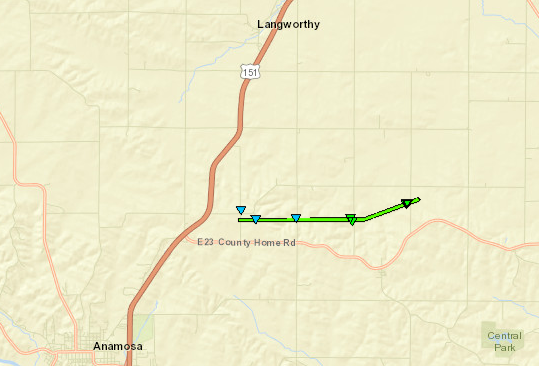 
|
||||||||||||||||
The Enhanced Fujita (EF) Scale classifies tornadoes into the following categories:
| EF0 Weak 65-85 mph |
EF1 Moderate 86-110 mph |
EF2 Significant 111-135 mph |
EF3 Severe 136-165 mph |
EF4 Extreme 166-200 mph |
EF5 Catastrophic 200+ mph |
 |
|||||
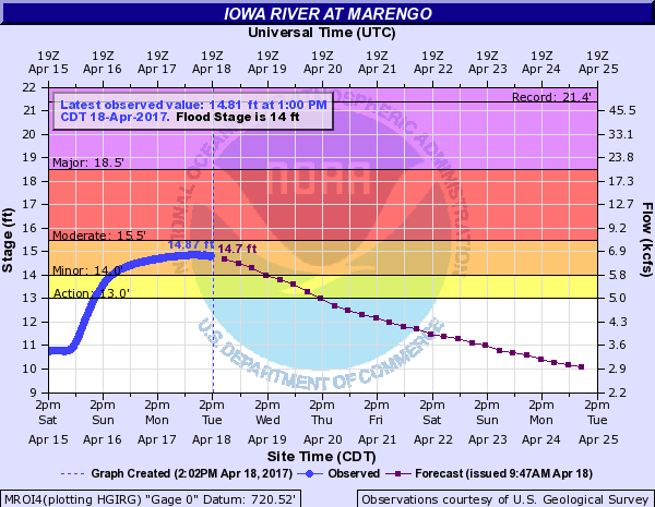
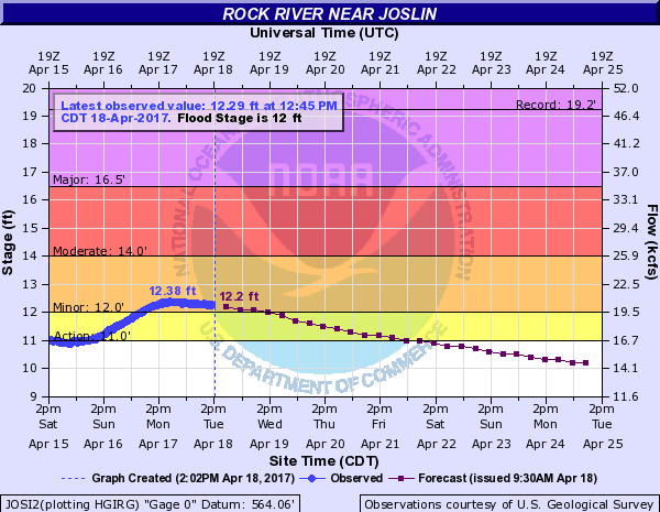
Flooding
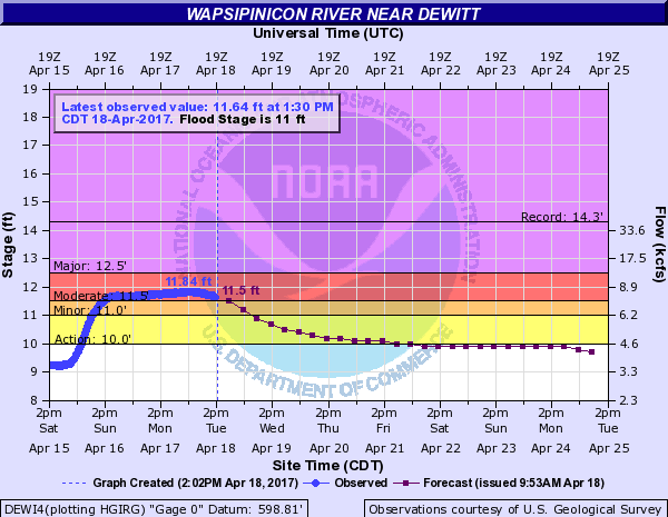
Hydrographs
 |
 |
 |
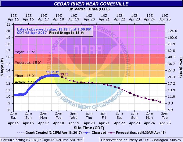 |
| DeWitt | Marengo | Joslin | Conesville |
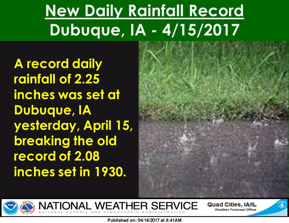
Record Rainfall
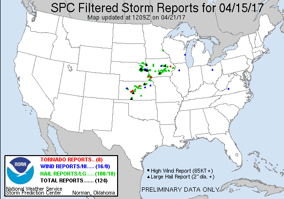
Storm Reports
| Interactive Map | SPC Reports |
 |
 |
PRELIMINARY LOCAL STORM REPORT...SUMMARY NATIONAL WEATHER SERVICE QUAD CITIES IA IL 1109 PM CDT SAT APR 15 2017 ..TIME... ...EVENT... ...CITY LOCATION... ...LAT.LON... ..DATE... ....MAG.... ..COUNTY LOCATION..ST.. ...SOURCE.... ..REMARKS.. 0458 PM HAIL 1 N WEBSTER 41.45N 92.17W 04/15/2017 E0.88 INCH KEOKUK IA FIRE DEPT/RESCUE LOTS OF PEA TO DIMES. 0505 PM HAIL NORTH ENGLISH 41.52N 92.08W 04/15/2017 E0.50 INCH IOWA IA TRAINED SPOTTER PEA TO DIMES. 0523 PM HAIL RIVERSIDE 41.48N 91.57W 04/15/2017 E1.00 INCH WASHINGTON IA TRAINED SPOTTER 0538 PM HAIL BALDWIN 42.07N 90.84W 04/15/2017 M0.25 INCH JACKSON IA TRAINED SPOTTER 0543 PM HAIL LOWDEN 41.86N 90.92W 04/15/2017 M0.25 INCH CEDAR IA CO-OP OBSERVER 0548 PM HAIL IOWA CITY 41.66N 91.54W 04/15/2017 M0.25 INCH JOHNSON IA TRAINED SPOTTER 0600 PM HAIL SW KALONA 41.48N 91.71W 04/15/2017 M0.25 INCH WASHINGTON IA TRAINED SPOTTER 0605 PM HAIL SW KALONA 41.48N 91.71W 04/15/2017 M0.88 INCH WASHINGTON IA TRAINED SPOTTER 0611 PM HAIL CALAMUS 41.83N 90.76W 04/15/2017 M1.00 INCH CLINTON IA BROADCAST MEDIA RELAYED FROM KWQC, TIME ESTIMATED BASED ON RADAR. 0611 PM HAIL 6 W TIPTON 41.77N 91.25W 04/15/2017 M0.25 INCH CEDAR IA TRAINED SPOTTER 0617 PM HAIL 2 SSE HILLS 41.55N 91.53W 04/15/2017 M0.50 INCH JOHNSON IA TRAINED SPOTTER 0620 PM HAIL GRAND MOUND 41.82N 90.65W 04/15/2017 E1.00 INCH CLINTON IA BROADCAST MEDIA RELAYED BY KWQC...TIME ESTIMATED FROM RADAR. 0630 PM HAIL S DEWITT 41.82N 90.55W 04/15/2017 M1.50 INCH CLINTON IA NWS EMPLOYEE FROM AN OFF DUTY NWS EMPLOYEE, TIME ESTIMATED ON RADAR 0633 PM HAIL DEWITT 41.82N 90.55W 04/15/2017 M0.88 INCH CLINTON IA NWS EMPLOYEE 0635 PM HAIL DEWITT 41.82N 90.55W 04/15/2017 M1.00 INCH CLINTON IA NWS EMPLOYEE 0705 PM HAIL KESWICK 41.46N 92.24W 04/15/2017 M1.75 INCH KEOKUK IA BROADCAST MEDIA RELAYED FROM KCRG, TIME ESTIMATED 0715 PM HAIL S MILLERSBURG 41.57N 92.16W 04/15/2017 E0.25 INCH IOWA IA EMERGENCY MNGR 0722 PM HAIL 3 NNE DYSART 42.21N 92.30W 04/15/2017 M0.25 INCH BENTON IA TRAINED SPOTTER 0724 PM HAIL WSW BLAIRSTOWN 41.90N 92.09W 04/15/2017 M0.50 INCH BENTON IA TRAINED SPOTTER 0738 PM HAIL 5 S URBANA 42.15N 91.88W 04/15/2017 M1.00 INCH BENTON IA TRAINED SPOTTER TIME ESTIMATED FROM RADAR. 0741 PM HAIL 4 N MARENGO 41.85N 92.07W 04/15/2017 M0.25 INCH IOWA IA TRAINED SPOTTER 0749 PM HAIL SW CEDAR RAPIDS 41.97N 91.67W 04/15/2017 M0.25 INCH LINN IA PUBLIC 0750 PM HAIL 2 W CEDAR RAPIDS 41.98N 91.71W 04/15/2017 M0.25 INCH LINN IA TRAINED SPOTTER 0807 PM HAIL KEYSTONE 42.00N 92.20W 04/15/2017 M0.25 INCH BENTON IA EMERGENCY MNGR 0813 PM HAIL 1 N SHELLSBURG 42.11N 91.87W 04/15/2017 M1.00 INCH BENTON IA PUBLIC REPORT AND PHOTO FROM TWITTER...TIME ESTIMATED FROM RADAR. 0816 PM HAIL N SHELLSBURG 42.09N 91.87W 04/15/2017 M0.25 INCH BENTON IA EMERGENCY MNGR 0820 PM HAIL PALO 42.06N 91.80W 04/15/2017 M0.25 INCH LINN IA PUBLIC REPORT VIA FACEBOOK. 0824 PM FUNNEL CLOUD 5 N CENTRAL CITY 42.28N 91.52W 04/15/2017 LINN IA FIRE DEPT/RESCUE POSSIBLE FUNNEL SEEN DURING A LIGHTNING STRIKE. 0826 PM HAIL 2 SSW TODDVILLE 42.08N 91.73W 04/15/2017 M0.25 INCH LINN IA TRAINED SPOTTER 0829 PM HAIL W BELLE PLAINE 41.90N 92.28W 04/15/2017 M1.00 INCH BENTON IA TRAINED SPOTTER 0840 PM HAIL N MARION 42.03N 91.59W 04/15/2017 M0.25 INCH LINN IA EMERGENCY MNGR 0840 PM HAIL SSE ROBINS 42.08N 91.67W 04/15/2017 E0.25 INCH LINN IA COCORAHS 0843 PM HAIL 1 N MARION 42.04N 91.59W 04/15/2017 M0.25 INCH LINN IA TRAINED SPOTTER 0853 PM HAIL W BELLE PLAINE 41.90N 92.28W 04/15/2017 M1.00 INCH BENTON IA TRAINED SPOTTER 0922 PM HEAVY RAIN MARION 42.03N 91.59W 04/15/2017 M1.20 INCH LINN IA BROADCAST MEDIA RAINFALL OVER THE PAST HOUR AT MARION HS. 0925 PM HAIL 3 NNW CEDAR RAPIDS 42.02N 91.70W 04/15/2017 M0.50 INCH LINN IA TRAINED SPOTTER 1013 PM HEAVY RAIN 3 ENE MARION 42.05N 91.54W 04/15/2017 M2.50 INCH LINN IA TRAINED SPOTTER RAINFALL TOTAL IN PAST 3 HOURS. |
|
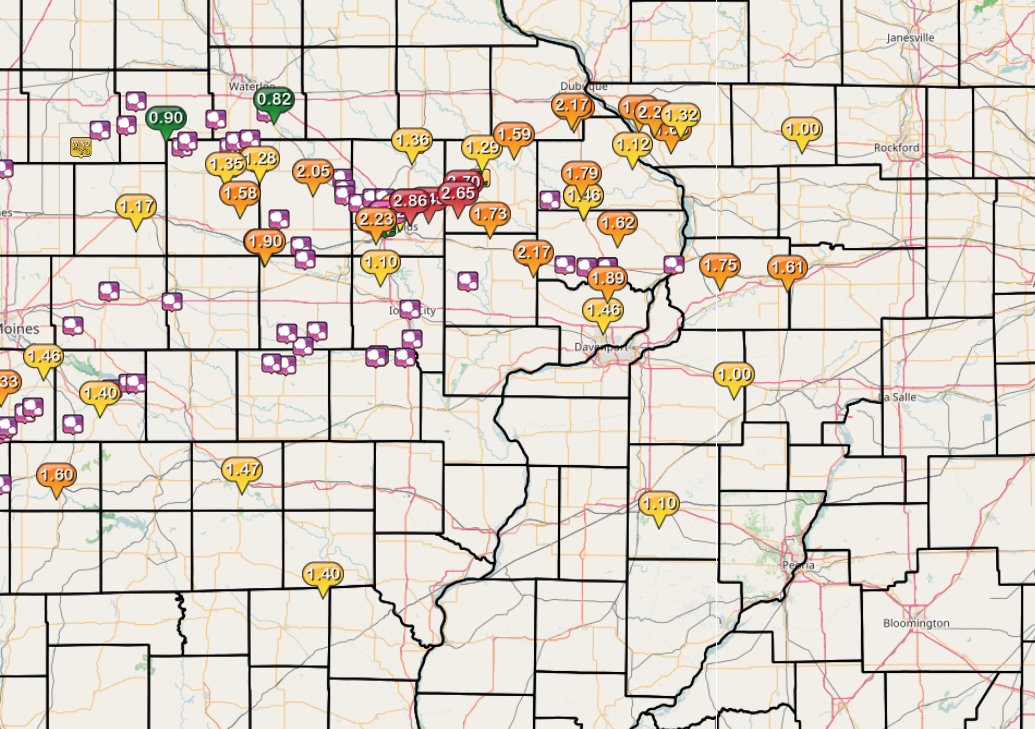
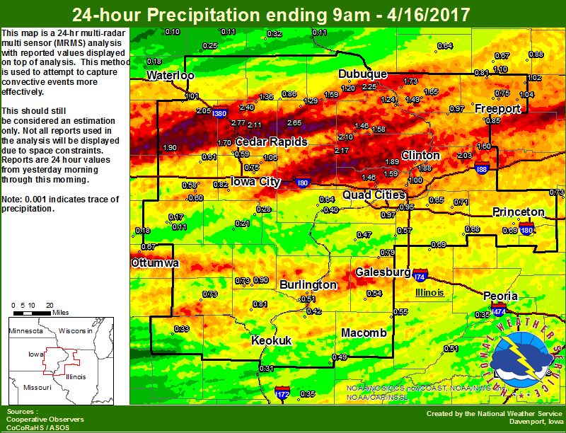
Rain Reports
| Local Rainfall Map | Radar Estimated Rainfall Map |
 |
 |
24 hour precipitation reports (in Inches), for eastern Iowa, northwest and west central Illinois, and northeast Missouri. Reported between Midnight and 9 AM, Sunday April 16, 2017. ....IOWA.... Robins 0.4 SSE 2.77 Marion 1.2 NE 2.77 Anamosa 3 SSW 2.65 Cedar Rapids 3.4 NW 2.44 Center Point 0.6 NNW 2.44 Central City 6.7 W 2.40 Pella AWOS 2.31 Dubuque Arpt 2.25 Lowden 2.17 Dubuque #3 2.17 Marion 1.7 NNW 2.11 Lost Nation 0.3 S 2.10 Vinton 2.05 Belle Plaine 1.90 De Witt 4S 1.89 Camanche 1.2 W 1.88 Cedar Rapids 2.2 WSW 1.70 Cascade 1.59 Park View 0.2 WSW 1.59 Delmar 2.3 NW 1.58 Maquoketa 4W 1.46 Eldridge 0.7 SSW 1.46 Coggon 1.36 Monticello 1.29 Bellevue 0.3 SSW 1.24 NWS Johnston* 1.24 Peosta 2.9 E 1.20 Marshalltown 1.17 Bellevue LD12 1.12 Solon 0.3 ESE 1.06 Davenport Arpt 1.02 Mount Auburn 2.2 NNW 1.01 Toledo 1.01 Le Claire 1.8 NNE 1.00 Iowa City Arpt 0.96 Salem 3.1 ESE 0.90 Bettendorf 2.2 SE 0.88 Keokuk 0.6 NE 0.88 Hopkinton 5.4 WSW 0.86 Dubuque LD11 0.86 Pella 0.85 Kalona 7.3 NNW 0.82 Donnellson 0.81 Eldridge 0.6 ESE 0.80 Iowa City 4.5 N 0.75 Salem 1S 0.73 Keokuk LD19 0.73 Keosauqua 0.73 Burlington Arpt 0.70 Ottumwa ASOS 0.67 Albia 0.66 Muscatine 2N 0.64 Davenport 0.9 SSW 0.63 Amana 4.7 W 0.61 Davenport 0.9 WNW 0.61 North English 0.60 Cedar Rapids Arpt 0.59 Parnell 0.1 SSW 0.58 Davenport 2.9 W 0.56 Grinnell AWOS 0.53 Burlington 6.5 SSW 0.51 Williamsburg 0.45 Boone 0.41 Hampton 0.36 Centerville 0.33 Perry 0.33 Elkader 6SSW 0.32 Ames US 30 0.30 Ainsworth 7.4 N 0.28 Newton 0.26 Oelwein AWOS 0.25 Mason City 0.24 Washington 0.21 Oskaloosa AWOS 0.18 Waterloo ASOS 0.18 Sigourney 1.1 W 0.17 Beaconsfield 0.17 Mason City ASOS 0.12 Fayette 0.11 Guttenberg Dam 10 0.11 Sigourney 0.11 Tripoli 0.10 Marshalltown ASOS 0.02 ....ILLINOIS.... Morrison 3.2 E 2.03 Rockford ASOS 1.82 Galena 1.73 Elizabeth 1.65 Coleta 1.4 SSW 1.60 Hanover 0.2 NW 1.49 Orangeville 2.8 NW 1.10 Ridott 0.1 NE 1.04 Davis 0.5 N 1.02 Mount Carroll 6.8 NNW 0.97 Quad City Arpt 0.97 Coal Valley 1.9 SE 0.95 Roscoe 2SE 0.95 Paw Paw 0.89 Shannon 0.2 S 0.85 Freeport 0.83 Winslow 4.3 ESE 0.81 Galesburg Arpt 0.81 Galesburg 0.80 Alexis 0.79 Colchester 3.5 NE 0.79 Pearl City 0.4 SW 0.77 Macomb 0.76 Macomb 0.6 WNW 0.75 Freeport 2.0 NW 0.75 Mendota 0.73 Atkinson 2.6 NNE 0.71 Tiskilwa 2.1 N 0.69 Altona 0.69 Kewanee 0.68 Geneseo 2.0 NW 0.65 Ottawa 0.64 Mundelein 0.62 Princeton 1.5 S 0.59 New Windsor 2.0 N 0.57 Prairie City 2S 0.55 Roseville 0.6 WNW 0.54 Havana 0.51 Decatur Airport 0.49 Augusta 0.49 Lincoln NWS 0.48 Aledo 0.47 Jacksonville AWOS 0.43 Romeoville 0.42 Dallas City 3.0 SSE 0.42 Ill. City LD16 0.40 Quincy ASOS 0.35 Peoria ASOS 0.35 Joliet 0.34 Bloomington Airport 0.29 Tuscola 0.27 Quincy Dam 21 0.26 Ogden 0.16 St Anne 0.13 Windsor 0.00 Rochelle AWOS 0.00 ....MISSOURI.... Memphis 0.33 Canton LD20 0.31 Chillicothe 0.09 Columbia 0.08 Kirksville ASOS 0.01 ....WISCONSIN.... Allenton-WWTP 1.12 Whitewater 1.02 Beloit-College 0.97 Steuben 4SE 0.94 Madison-ASOS 0.88 Brodhead 0.88 Sullivan-NWS 0.79 Watertown-AWOS 0.73 Monroe 0.67 Darlington 0.64 La Crosse WFO 0.06 Prairie du Chien AWOS 0.04 ....MINNESOTA.... Preston 0.17 Byron 4N 0.11 Theilman 1SSW 0.00 |
|
 |
Media use of NWS Web News Stories is encouraged! Please acknowledge the NWS as the source of any news information accessed from this site. |
|