Scattered thunderstorms with severe gusts, hail and a tornado risk are possible near a cold front from the Ohio Valley to the Mid-Atlantic tonight. Tropical Storm Bertha is expected to bring tropical storm conditions to portions of the Gulf Coast from the panhandle of Florida into Louisiana through Wednesday. Read More >
Overview
|
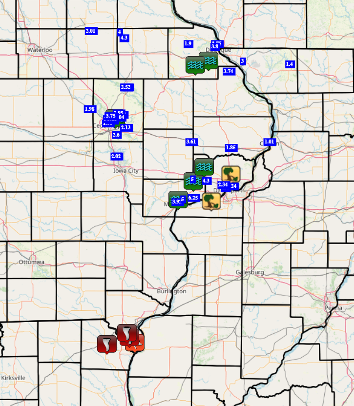
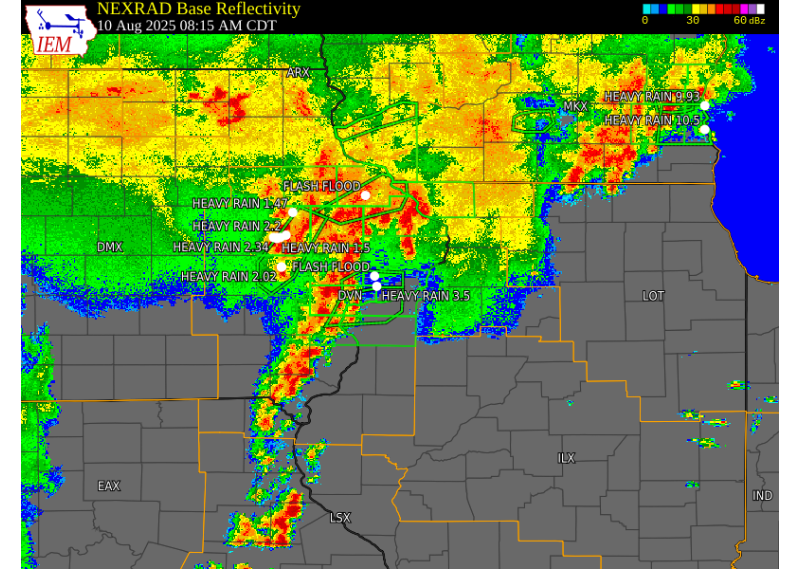
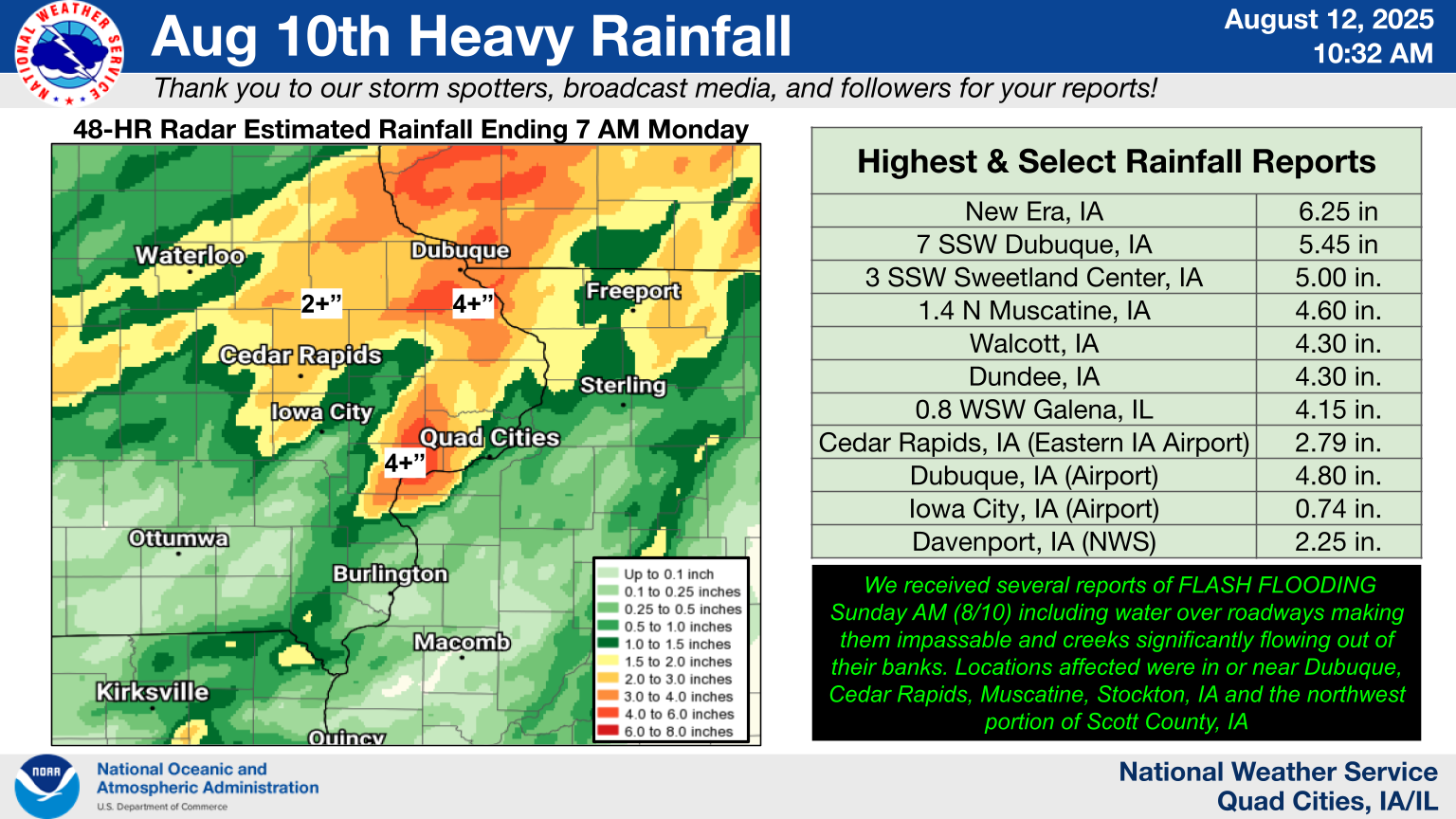
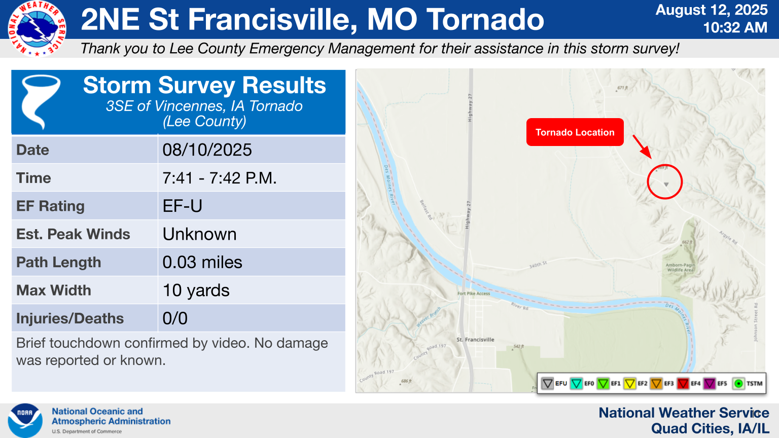
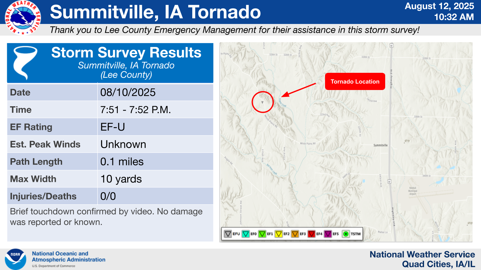
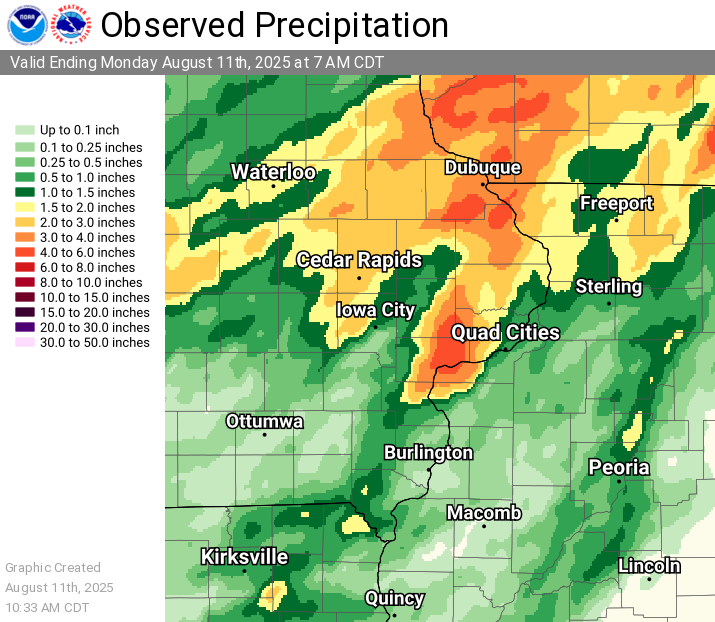
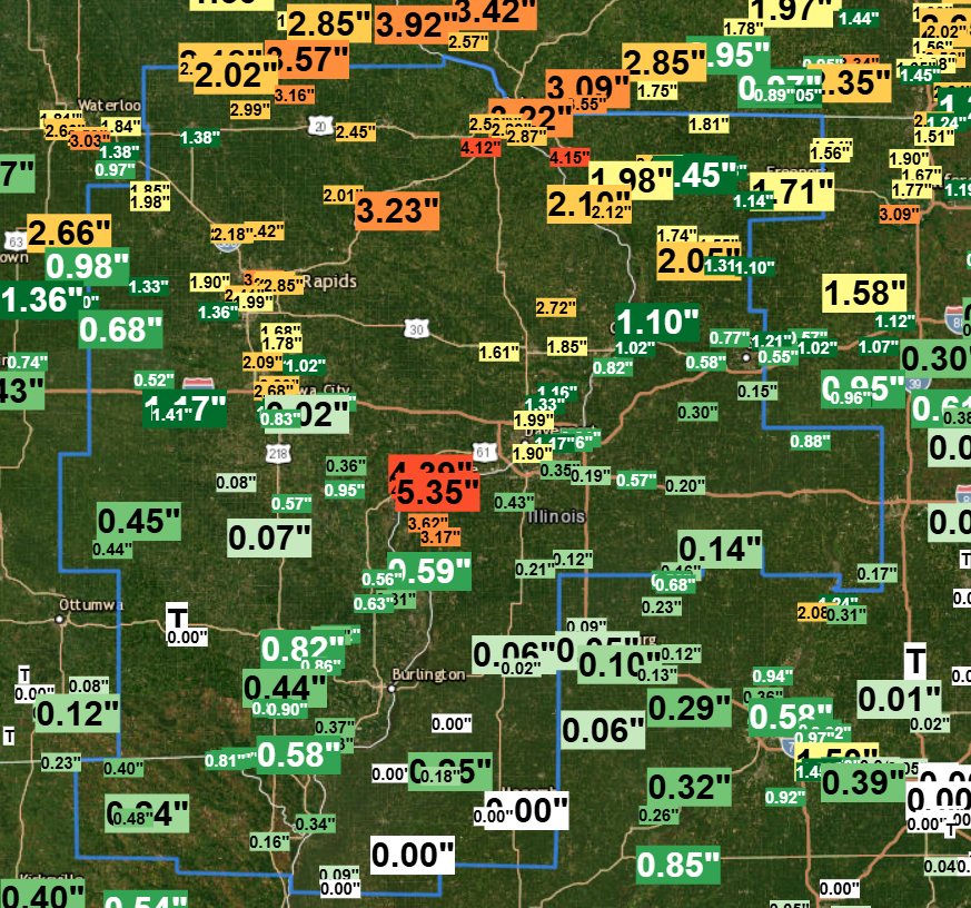
Multiple rounds of thunderstorms tracked across the area early Sunday, bringing very heavy rain, frequent lightning, and some localized gusty winds. Rainfall rates over 2"/hr on top of saturated ground caused flash flooding with water over roadways and creeks overflowing. Late afternoon and evening storms brought more heavy rain and three brief tornadoes in Lee county in Iowa and Clark county in Missouri. No damage was reported or seen with these tornadoes. |
 |
 |
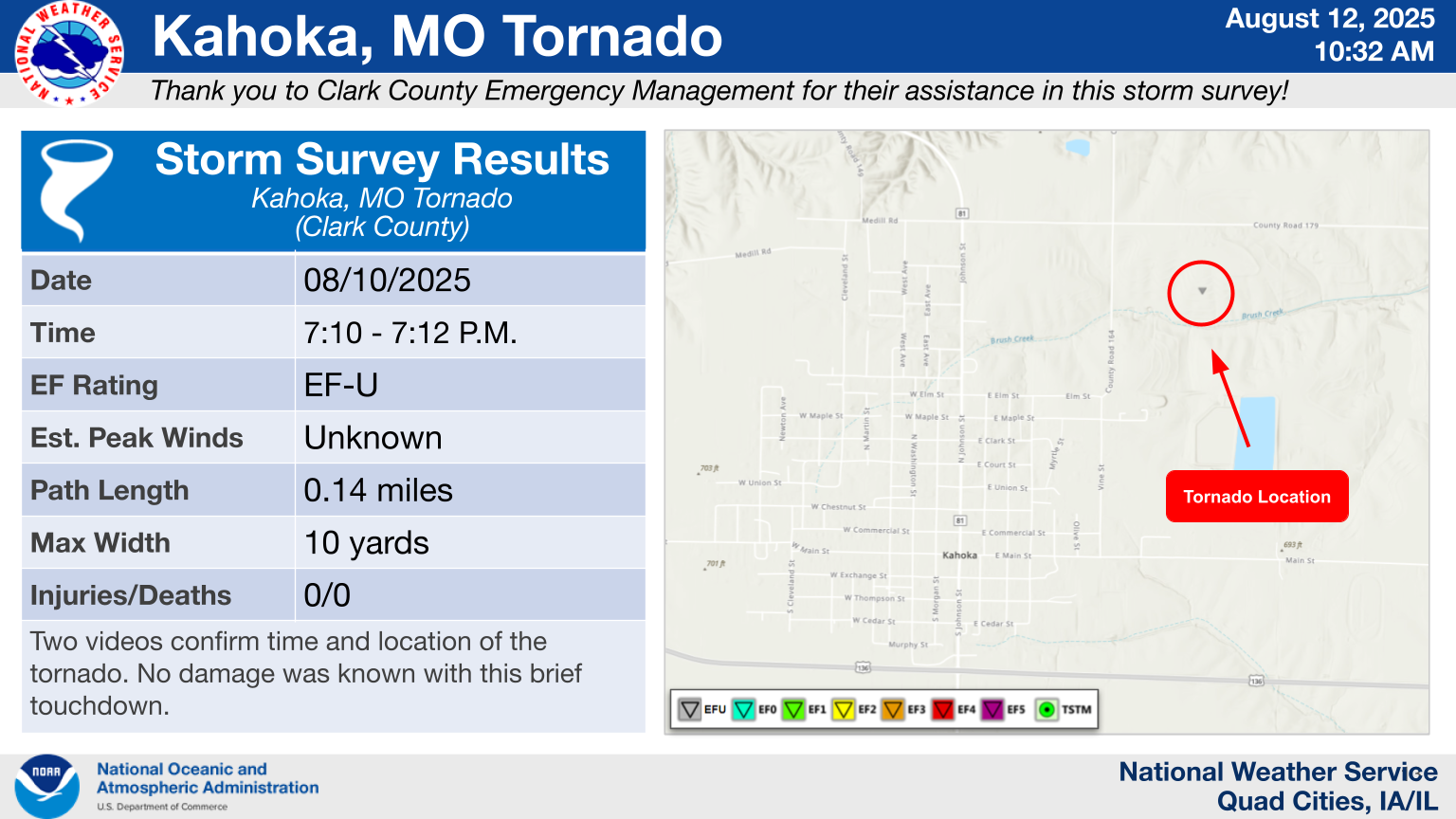 |
| Heavy Rain Summary | St. Francisville, MO Tornado Infographic | Kahoka, MO Tornado Infographic |
 |
Public Information Statement |
|
| Summitville, IA Tornado Infographic |
Tornadoes
Select a tornado from the table to zoom into the track and view more information. The default table view is limited to 8 tracks, but can be scrolled by a mouse wheel or dynamically expanded. Additionally, the table can fill the entire window by clicking the small circular expanding arrow icon at the very top right of the table and returned to its original size by clicking the button again. The side information panel that opens over the map can be closed using the "X" on the upper right corner of the pop-up. Zoom into the map and click damage points to see detailed information and pictures from the surveys.
|
NOTE: times shown below are local to your device's time zone. |

The Enhanced Fujita (EF) Scale classifies tornadoes into the following categories:
| EF0 Weak 65-85 mph |
EF1 Moderate 86-110 mph |
EF2 Significant 111-135 mph |
EF3 Severe 136-165 mph |
EF4 Extreme 166-200 mph |
EF5 Catastrophic 200+ mph |
 |
|||||
| Tornadoes that fail to impact any ratable damage indicators on the EF-Scale are rated EF-Unknown (EF-U) | |||||
Rain Reports
 |
 |
 |
| 48-hr Rainfall Ending 8/10 | 48-hr Coop / CoCoRaHS Reports |
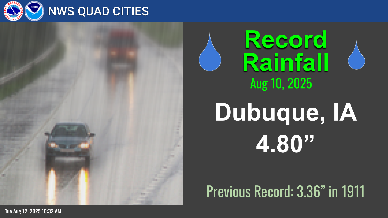
Dubuque, IA Record Rainfall - Aug 10th |
...Highest 48-hr Rainfall Reports...

Observations are collected from a variety of sources with varying
equipment and exposures. We thank all volunteer weather observers
for their dedication. Not all data listed are considered official.

Location                     Amount    Time/Date       Provider
New Era                      6.25 in   0747 PM 08/10   Trained Spotter
Dubuque 7 SSW                5.45 in   0600 AM 08/11   COOP
3 SSW Sweetland Center       5.00 in   1126 AM 08/10   Public
Muscatine 1.4 N              4.60 in   0700 AM 08/11   COCORAHS
Muscatine 3.0 NE             4.53 in   0800 AM 08/11   COCORAHS
2 N Muscatine                4.39 in   0700 AM 08/11   COOP
Walcott                      4.30 in   1109 AM 08/10   NWS Employee
Dundee                       4.30 in   1235 PM 08/10   Emergency Mngr
Galena 0.8 WSW               4.15 in   0700 AM 08/11   COCORAHS
Peosta 2.9 E                 4.12 in   0700 AM 08/11   COCORAHS
Lowden                       4.11 in   0700 AM 08/11   CO-OP Observer
3 ENE Lamont                 4.00 in   1235 PM 08/10   Emergency Mngr
1 NW Dubuque                 3.80 in   1205 PM 08/10   Trained Spotter
1 SE Hiawatha                3.75 in   0827 PM 08/10   Trained Spotter
2 SW Saint Donatus           3.74 in   1130 AM 08/10   Trained Spotter
Illinois City 6.7 SW         3.62 in   0700 AM 08/11   COCORAHS
Wheatland                    3.39 in   0950 AM 08/11   CWOP
1 SSW Muscatine Airport      3.25 in   0720 AM 08/11   Trained Spotter
Monticello                   3.23 in   0600 AM 08/11   COOP
Cedar Rapids 5.8 N           3.23 in   0700 AM 08/11   COCORAHS
1 NE Dundee                  3.16 in   0700 AM 08/11   COCORAHS
1 W Galena                   3.00 in   1147 AM 08/10   Trained Spotter
Winthrop 5.6 NNE             2.99 in   0900 AM 08/11   COCORAHS
Marion                       2.97 in   0700 AM 08/11   COCORAHS
2 NNW Marion                 2.95 in   0413 PM 08/10   Trained Spotter
Quasqueton                   2.90 in   0945 AM 08/11   CWOP
Dubuque 1.0 SE               2.89 in   0645 AM 08/11   COCORAHS
East Dubuque 1.7 SE          2.87 in   0700 AM 08/11   COCORAHS
Marion 1.6 WNW               2.85 in   0700 AM 08/11   COCORAHS
Marion                       2.85 in   0800 AM 08/11   COCORAHS
Marion 1.7 NNW               2.80 in   0615 AM 08/11   COCORAHS
Dubuque 1.4 WNW              2.80 in   0700 AM 08/11   COCORAHS
1 SSE Edmore                 2.75 in   0845 PM 08/10   Trained Spotter
3 NNE Cedar Rapids           2.74 in   0410 AM 08/11   Trained Spotter
Charlotte 1.9 WNW            2.72 in   0700 AM 08/11   COCORAHS
Hiawatha                     2.70 in   1147 AM 08/10   Trained Spotter
3 NNE Cedar Rapids           2.68 in   1050 AM 08/10   Trained Spotter
North Liberty 0.7 SSW        2.68 in   0800 AM 08/11   COCORAHS
3 NW Ely                     2.60 in   0304 PM 08/10   Emergency Mngr
Asbury 0.4 SW                2.59 in   0700 AM 08/11   COCORAHS
Davenport                    2.55 in   0945 AM 08/11   CWOP
3 S Coggon                   2.52 in   1022 PM 08/10   Trained Spotter
Manchester                   2.50 in   0700 AM 08/11   COOP
Central City 6.7 W           2.42 in   0700 AM 08/11   COCORAHS
Holy Cross 1.8 E             2.41 in   0700 AM 08/11   COCORAHS
North Liberty 1.0 ENE        2.39 in   0700 AM 08/11   COCORAHS
Vinton 3.6 SE                2.37 in   0700 AM 08/11   COCORAHS
1 NW Davenport               2.34 in   0720 PM 08/10   Trained Spotter
3.9 S Dewitt                 2.27 in   0930 AM 08/11   HADS
Urbana                       2.26 in   0945 AM 08/11   CWOP
Amana                        2.25 in   0950 AM 08/11   CWOP
Davenport Arpt               2.18 in   0859 AM 08/11   ASOS
1 WNW Dubuque                2.16 in   0723 AM 08/11   Cocorahs
Independence                 2.16 in   0930 AM 08/11   CWOP
Central City                 2.14 in   0945 AM 08/11   CWOP
Hanover 0.2 NW               2.12 in   0700 AM 08/11   COCORAHS
Winthrop                     2.12 in   0945 AM 08/11   CWOP
Eldridge 0.7 SSW             2.06 in   0800 AM 08/11   COCORAHS
2 ENE Hazleton               2.01 in   0100 PM 08/10   CO-OP Observer
Hopkinton 5.4 WSW            2.01 in   0700 AM 08/11   COCORAHS
Depue                        2.00 in   0307 PM 08/10   Public
Stockton 5.9 WNW             2.00 in   0700 AM 08/11   COCORAHS
Macnhester                   2.00 in   0945 AM 08/11   CWOP
 |
Media use of NWS Web News Stories is encouraged! Please acknowledge the NWS as the source of any news information accessed from this site. |
|