Overview
|
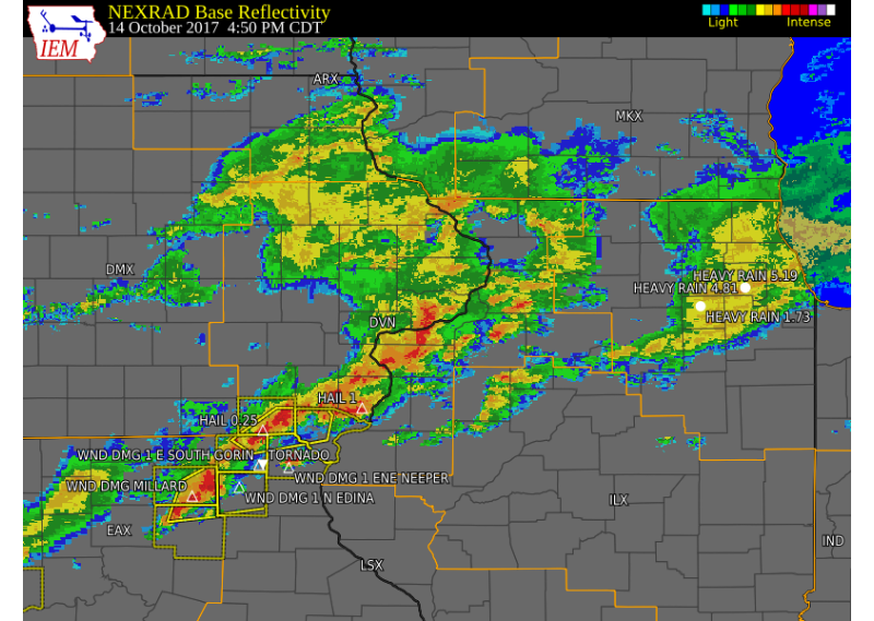
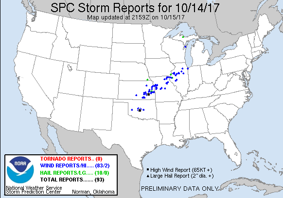
Several rounds of showers and thunderstorms developed across the region on Saturday, October 14th, ahead of a strong storm system moving across the central Great Plains. Some of these thunderstorms became severe, producing large hail up to half dollar size, wind damage across Warren, Clark, and Scotland counties, heavy rainfall from 1 to 3 inches over eastern Iowa and northwest Illinois, and two tornadoes. One tornado touched down just east of Gorin, MO completely destroying a farm outbuilding and damaging two other buildings. The other tornado touched down west of Bowen IL. |
Tornadoes:
|
Tornado #1 - 2 E Gorin, MO
Track Map 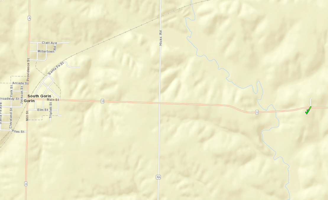 
|
||||||||||||||||||||
|
Tornado #2 - W of Bowen IL
Track Map 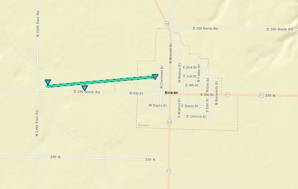 |
||||||||||||||||
The Enhanced Fujita (EF) Scale classifies tornadoes into the following categories:
| EF0 Weak 65-85 mph |
EF1 Moderate 86-110 mph |
EF2 Significant 111-135 mph |
EF3 Severe 136-165 mph |
EF4 Extreme 166-200 mph |
EF5 Catastrophic 200+ mph |
 |
|||||
Storm Reports
| Interactive Storm Report Map | SPC Storm Reports |
 |
 |
PRELIMINARY LOCAL STORM REPORT...SUMMARY
NATIONAL WEATHER SERVICE QUAD CITIES IA IL
913 PM CDT SAT OCT 14 2017

..TIME...   ...EVENT...      ...CITY LOCATION...     ...LAT.LON...
..DATE...   ....MAG....      ..COUNTY LOCATION..ST.. ...SOURCE....
            ..REMARKS..

0452 PM     HAIL             5 E CANTRIL             40.64N 91.98W
10/14/2017  M0.25 INCH       VAN BUREN          IA   TRAINED SPOTTER

0510 PM     HAIL             WEST BURLINGTON         40.82N 91.18W
10/14/2017  M1.00 INCH       DES MOINES         IA   EMERGENCY MNGR

0511 PM     TSTM WND DMG     1 E SOUTH GORIN         40.36N 92.01W
10/14/2017                   SCOTLAND           MO   TRAINED SPOTTER

            A FARMSTEAD WAS DAMAGED AND POWER LINES DOWN JUST EAST OF
            GORIN. POSSIBLE TORNADO. FIRST CALL CAME IN AT 512 PM.

0519 PM     TSTM WND DMG     1 ENE NEEPER            40.34N 91.77W
10/14/2017                   CLARK              MO   911 CALL CENTER

            CAR CRASHED INTO A LARGE TREE BRANCH THAT WAS DOWN ON THE
            HIGHWAY.

0548 PM     TSTM WND DMG     MONMOUTH                40.93N 90.63W
10/14/2017                   WARREN             IL   EMERGENCY MNGR

            APPROXIMATELY A 20 FOOT BY 80 FOOT SECTION OF ROOF TORN
            OFF THE FIRE STATION.

0548 PM     HAIL             MONMOUTH                40.91N 90.64W
10/14/2017  E1.00 INCH       WARREN             IL   EMERGENCY MNGR

0548 PM     HAIL             MONMOUTH                40.91N 90.64W
10/14/2017  E1.00 INCH       WARREN             IL   EMERGENCY MNGR

0550 PM     HAIL             1 N MONMOUTH MUNICIPAL  40.95N 90.63W
10/14/2017  M1.25 INCH       WARREN             IL   STORM CHASER

0629 PM     HEAVY RAIN       1 NE FORT MADISON       40.64N 91.33W
10/14/2017  M3.00 INCH       LEE                IA   TRAINED SPOTTER

            2.00 INCHES FELL THIS AFTERNOON.

0635 PM     HAIL             1 S PLYMOUTH            40.28N 90.92W
10/14/2017  E1.00 INCH       HANCOCK            IL   CO-OP OBSERVER

0730 PM     HEAVY RAIN       BUSHNELL                40.55N 90.50W
10/14/2017  M1.24 INCH       MCDONOUGH          IL   TRAINED SPOTTER

            RAINFALL SINCE 9AM THIS MORNING

0807 PM     HEAVY RAIN       1 ESE MUSCATINE         41.41N 91.06W
10/14/2017  M3.50 INCH       MUSCATINE          IA   TRAINED SPOTTER

            TOTAL RAINFALL SINCE EARLY MORNING

0821 PM     HEAVY RAIN       COYNE CENTER            41.40N 90.57W
10/14/2017  M5.60 INCH       ROCK ISLAND        IL   TRAINED SPOTTER

            RAINFALL SINCE MIDNIGHT - OFFICIAL NWS OBSERVER

0834 PM     HEAVY RAIN       SSE LE CLAIRE           41.60N 90.36W
10/14/2017  M3.10 INCH       SCOTT              IA   TRAINED SPOTTER

            RAINFALL SO FAR FOR TODAY.

0843 PM     HEAVY RAIN       SSW MORRISON            41.80N 89.97W
10/14/2017  M4.60 INCH       WHITESIDE          IL   TRAINED SPOTTER

            RAINFALL SINCE EARLY MORNING
|
|
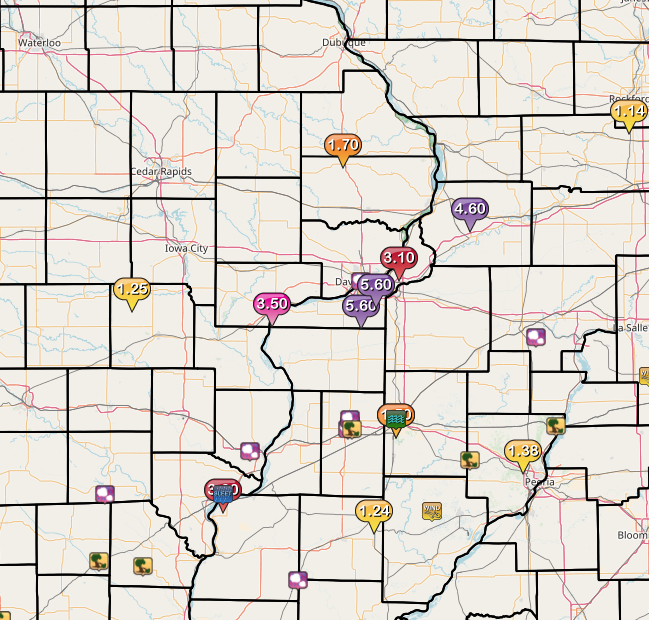
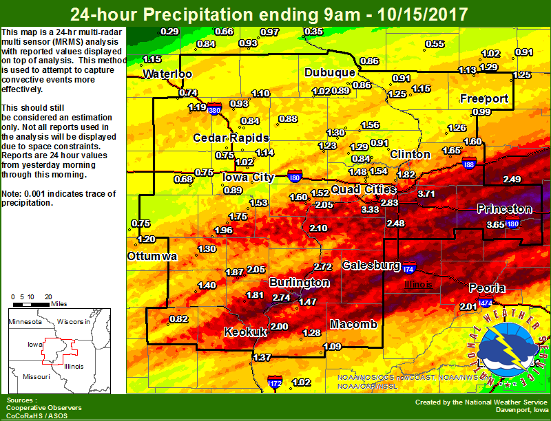
Rain Reports
 |
 |
 |
| Figure 1: Local 24-hr Rainfall |
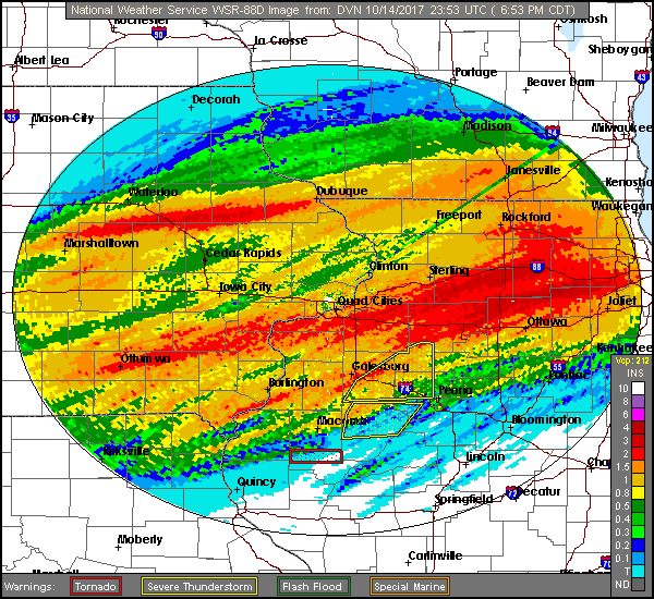
Figure 2: Radar Estimated Rainfall |
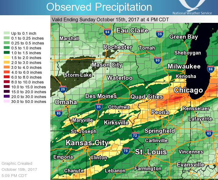
Figure 3: Regional 24-hr Rainfall |
24 hour precipitation reports (in Inches),
for eastern Iowa, northwest and west central Illinois,
and northeast Missouri. Reported between Midnight and 9 AM,
Sunday October 15, 2017.

....IOWA....
Fort Madison 0.9 NE              2.74
Burlington 6.5 SSW               2.51
Salem 3.1 ESE                    2.05
Keokuk LD19                      2.00
Burlington Arpt                  1.99
Brighton                         1.96
Salem 1S                         1.87
Le Claire 1.8 NNE                1.82
Donnellson                       1.81
Washington                       1.75
Muscatine 1.4 N                  1.60
Delmar 2.3 NW                    1.56
Davenport 0.9 WNW                1.55
Eldridge 0.6 ESE                 1.54
Ainsworth 7.4 N                  1.53
Muscatine 2N                     1.52
Eldridge 0.7 SSW                 1.48
Keosauqua                        1.40
De Witt 4S                       1.38
Davenport Arpt                   1.36
NWS Johnston*                    1.35
Lost Nation 0.3 S                1.30
Fairfield                        1.30
Toledo                           1.29
Calamus 2.0 NE                   1.29
Iowa City Arpt                   1.28
Bellevue LD12                    1.25
Lowden                           1.23
Center Point 0.6 NNW             1.22
Ottumwa ASOS                     1.20
Vinton                           1.19
Waterloo ASOS                    1.15
Solon 0.3 ESE                    1.14
Coggon                           1.10
Iowa City                        1.06
Cascade                          1.02
Iowa City 4.5 N                  1.02
Newton                           1.00
Marshalltown ASOS                0.98
Elkader 6SSW                     0.97
Marshalltown                     0.95
Central City 6.7 W               0.93
Strawberry Point                 0.93
Ely 0.5 SE                       0.93
Goose Lake 6.4 SSW               0.91
Kalona 7.3 NNW                   0.89
Dubuque #3                       0.89
Anamosa 3 SSW                    0.88
Marion 1.2 NE                    0.88
Dubuque Arpt                     0.86
Dubuque LD11                     0.86
Maquoketa 4W                     0.84
Oelwein AWOS                     0.84
De Witt                          0.84
Marion 1.7 NNW                   0.84
Grinnell                         0.79
Pella AWOS                       0.78
Oskaloosa AWOS                   0.75
Williamsburg                     0.75
Cedar Rapids Arpt                0.75
Mount Auburn 2.2 NNW             0.74
Parnell 0.1 SSW                  0.68
Fayette                          0.66
Cedar Rapids 2.7 NE              0.64
Cedar Rapids 2.2 WSW             0.63
Beaconsfield                     0.60
Grinnell AWOS                    0.59
Centerville                      0.53
Perry                            0.49
Boone                            0.43
Cresco                           0.37
Guttenberg Dam 10                0.35
Tripoli                          0.29
Hampton                          0.23
Mason City ASOS                  0.19
....ILLINOIS....
Romeoville                       4.29
Geneseo 2.0 NW                   3.71
Tiskilwa 2.1 N                   3.65
Princeton 1.1 SE                 3.41
Princeton                        3.41
Quad City Arpt                   3.33
Ottawa                           3.20
Rochelle AWOS                    3.14
Princeton 1.5 S                  2.87
Moline 0.7 NNE                   2.83
Gladstone LD18                   2.72
Steward                          2.62
Walnut 5.3 ENE                   2.49
New Windsor 2.0 N                2.48
Mundelein                        2.32
New Boston LD17                  2.10
Ill. City LD16                   2.05
Peoria ASOS                      2.01
Colchester 3.5 NE                1.77
Macomb                           1.72
Morrison 3.2 E                   1.65
Coleta 1.4 SSW                   1.60
Rockford ASOS                    1.53
Dallas City 3.0 SSE              1.47
Orangeville 2.8 NW               1.29
Bentley                          1.28
Chadwick 2.7 WSW                 1.26
Davis 0.5 N                      1.25
Elizabeth                        1.15
Winslow 4.3 ESE                  1.13
Augusta                          1.09
Roscoe 2SE                       1.06
Pearl City 0.4 SW                1.04
Quincy ASOS                      1.02
Shannon 0.2 S                    0.99
Freeport                         0.92
Galena                           0.91
Quincy Dam 21                    0.86
St Anne                          0.84
Ridott 0.1 NE                    0.83
Bloomington Airport              0.61
Lincoln NWS                      0.31
Decatur Airport                  0.27
Jacksonville AWOS                0.00
Joliet                           0.00
....MISSOURI....
Columbia                         1.41
Canton LD20                      1.37
Memphis                          0.82
Kirksville ASOS                  0.79
Chillicothe                      0.26
....WISCONSIN....
Beloit-College                   1.31
Monroe                           1.02
Delavan-1 W-WWTP                 0.94
Brodhead                         0.91
Whitewater                       0.79
Sullivan-NWS                     0.70
Steuben 4SE                      0.66
Prairie du Chien AWOS            0.62
Darlington                       0.55
Allenton-WWTP                    0.55
La Crosse WFO                    0.43
Watertown-AWOS                   0.36
Madison-ASOS                     0.32
....MINNESOTA....
Theilman 1SSW                    0.24
Byron 4N                         0.17
|
||
Environment
SPC Outlooks
 |
 |
 |
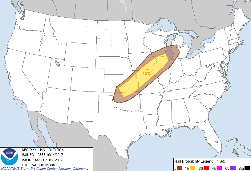 |
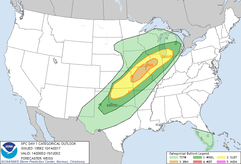
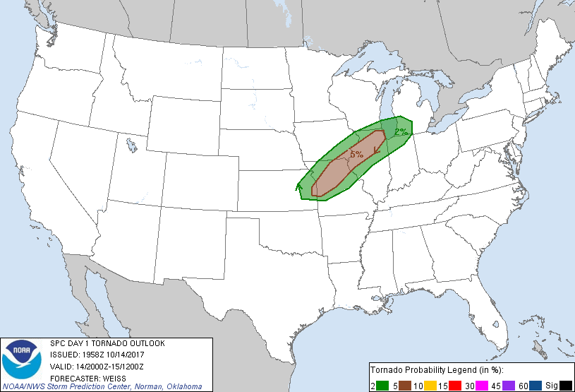
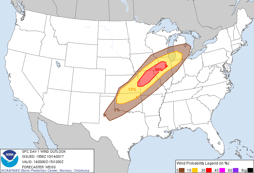
| Figure 1: SPC Day 1 Outlook | Figure 2: SPC Day 1 Tornado Outlook | Figure 3: SPC Day 1 Wind Outlook | Figure 4: SPC Day 1 Hail Outlook |
Near-storm environment
 |
 |
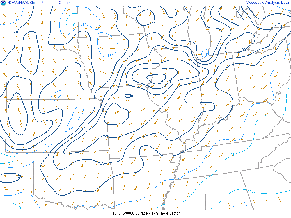 |
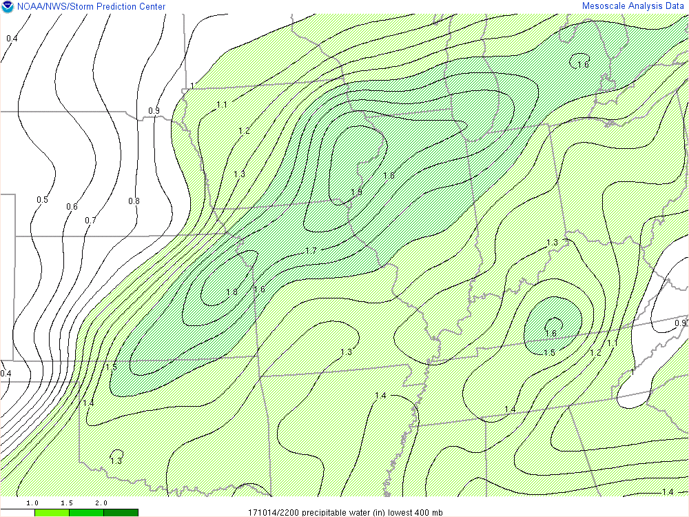
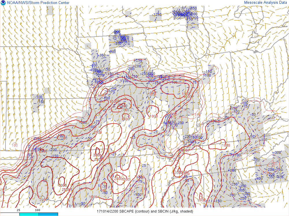
| Figure 5: Precipitable Water 22z 10/14 | Figure 6: SBCAPE/SBCIN 22z 10/14 | Figure 7: 0-1 km Shear 00z 10/15 |
Additional environmental data
 |
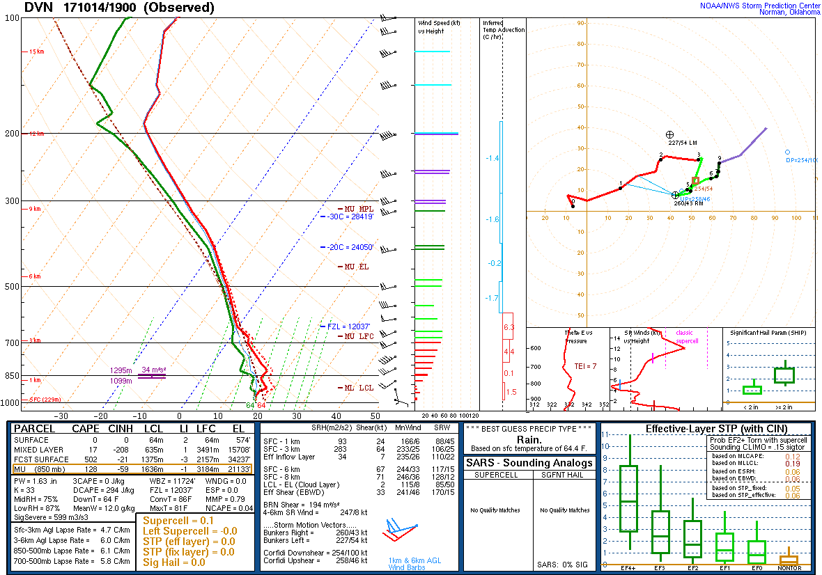 |
 |
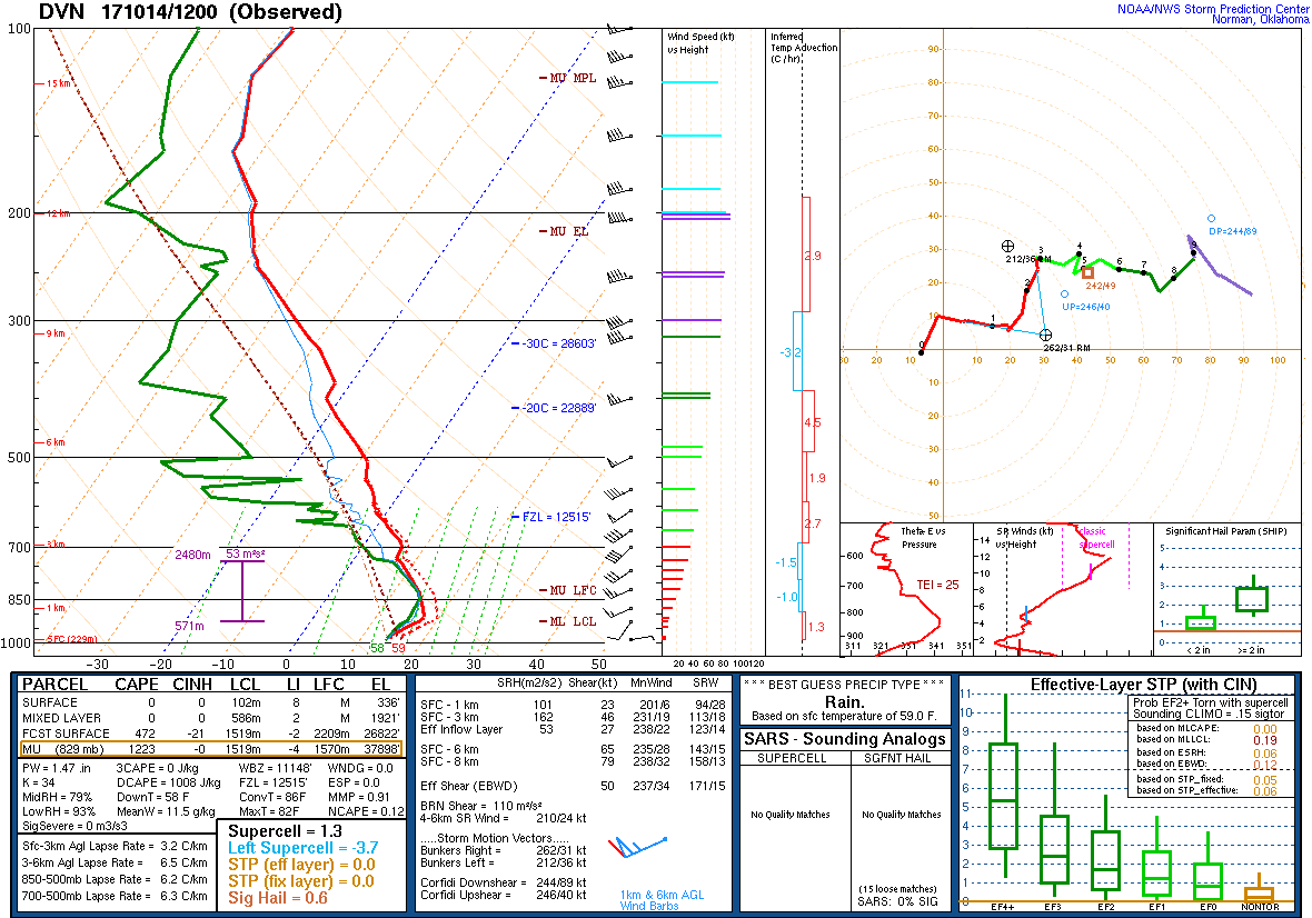
| Figure 8: 12z 10/14/17 DVN Sounding | Figure 9: 19z 10/14/17 DVN Sounding | Figure 10: 00z 10/15/17 DVN Sounding |
 |
Media use of NWS Web News Stories is encouraged! Please acknowledge the NWS as the source of any news information accessed from this site. |
|