National Weather Service United States Department of Commerce

2024 SKYWARN Storm Spotter Training

SKYWARN is a program that trains volunteers to help keep their local communities safe by providing timely and accurate reports of monsoon season weather to the National Weather Service. Read More >

Introduction

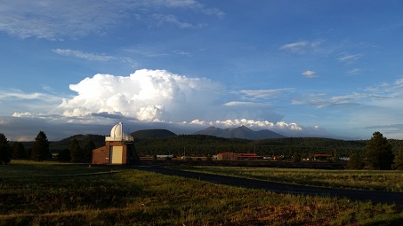
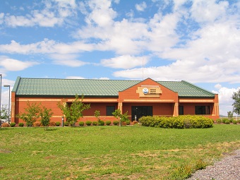
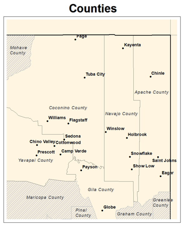
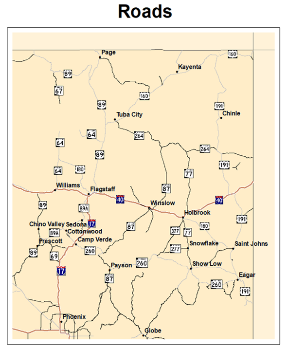
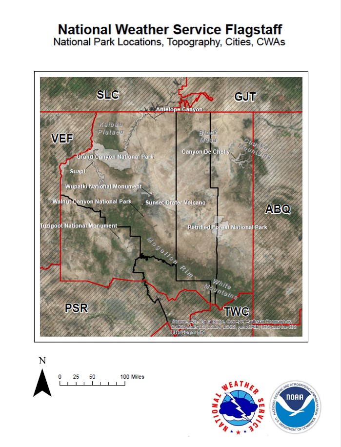
The National Weather Service office in Flagstaff serves five counties across northern Arizona: Coconino, Yavapai, Navajo, Apache, and northern Gila counties. The highest point in our forecast area is Mt. Humphreys (the highest point in the state of Arizona) at 12,633 feet above sea level; the lowest point in the area is near the town of Black Canyon City (near 2,000 feet above sea level). Due to these elevation differences, the Flagstaff office provides forecasts for a wide variety of weather conditions including heavy snowfall, bitter cold, severe thunderstorms, heavy rainfall, excessive heat and strong winds. Our office is located at Camp Navajo (Arizona Army National Guard) in Bellemont, AZ (about 10 miles west of Flagstaff).

We are on duty around-the-clock; our operations run 24 hours a day, 7 days a week. Due to the importance of our mission, NWS employees are considered essential and will continue working during government shutdowns. We are always on-the-job, protecting the public from the ever-present threats of mother nature!

Intrested in touring the NWS Flagstaff office? Click here for more information

Staff

Administrative


Brian Klimowski, Meteorologist-in-Charge (MIC)


The office leader. Responsible for directing all office operations, staff, and administrative programs.

Tony Merriman, Warning Coordination Meteorologist (WCM)


Outreach coordinator. Serves as the liaison between local and state government officials. Responsible for directing annual storm spotter training and is the primary contact for media inquiries and outreach events.

Vacant, Science Operations Officer (SOO)


Training coordinator. Responsible for training the staff and keeping abreast of the latest meteorological/technological advances and oversees research activities taking place in the office.

Dave Olson, Electronic Systems Analyst (ESA)


Manages the office electronic staff and maintenance program. Oversees the maintenance of the Doppler radar, NOAA weather radio, and observing equipment.

Robert Rickey, Information Technology Officer (ITO)


Local IT expert. Performs software support for operations, while ensuring system stability and security. Also serves as the primary fire weather point of contact.

Larry Dooley, Observation Program Leader (OPL)


Maintains and enhances the Cooperative Observation Program which collects climate data throughout northern and central Arizona. May occasionally perform duties as a Meteorologist.

Krista Ames-Cook, Administrative Support Assistant (ASA)


Performs office and staff administrative tasks, including payroll and budget/travel expenses.

Meteorologists


Lead Forecasters (Staff of 5)


Operational meteorologists and shift supervisors. Prepares various forecast products and is responsible for the quality and timeliness of all products and services produced by the office. Each has one or more specialized areas of expertise (focal points).

Forecasters (Staff of 7)


Operational meteorologists responsible for all routine and non-routine forecast products prepared and issued. Each has one or more specialized areas of expertise (focal points).

Technicians


Jeremy Johnson and Vacant, Electronic Technicians (ET)


Perform routine and non-routine maintenance of all office electronic equipment. Maintain the Doppler radar, NOAA weather radio, and observing equipment.

Counties and Cities of northern Arizona Roads of Northern Arizona

Population Centers

Top 10 Most Populous Cities (2020 Census)

  1. Flagstaff - 76,831
  2. Prescott Valley - 46,785
  3. Prescott - 45,827
  4. Payson - 16,351
  5. Chino Valley - 13,020
  6. Camp Verde - 12,147
  7. Cottonwood - 12,029
  8. Show Low - 11,732
  9. Sedona - 9,684
  10. Winslow - 9,005

Roadways

Interstate 17

  • Interstate 17 generally provides the most direct and fastest route between Phoenix and Flagstaff.
  • Weather conditions along I-17 will vary widely, especially in the winter, due to the large changes in elevation (ranging from 1,000 feet up to 7,000 ft above sea level). There could be snow and ice covered roads in the high terrain and sunny skies closer to Phoenix.

Interstate 40

  • Interstate 40 spans east to west across northern Arizona (retracing much of Old Route 66) and reaches its highest elevation in the US just west of Flagstaff.
  • It is common to experience snow and ice on the roadways during the winter months and blowing dust near Winslow and Holbrook during the warmer seasons

US Route 89

  • This US Highway connects Flagstaff to Utah along a relatively flat stretch through the Painted Desert and across the Glen Canyon Dam.
  • Much of this highway can be impacted by snow and ice during a winter storm because the elevation rarely dips below 4,000 feet above sea level. Make sure to pack extra water during the summer months as portions of this roadway can regularly experience temperatures near or above 100 F.

US Route 160

  • Look to use this road if you will be traveling from east to west in north central or north eastern Arizona within Navajo Nation.
  • Flash floods can impact roadways in the region that US Route 160 is situated in. Never drive into a flooded roadway as it is nearly impossible to tell the depth of water flowing over the road.

US Route 191

  • In northern Arizona, this route traverses through Navajo Nation and should be driven cautiously during the winter due to heavy mountain snow. There are places with sharp curves and little to no shoulder in many spots.
  • This road is prone to gusty springtime winds. Thunderstorms with heavy rain, hail and lightning are also common during the monsoon season near areas of high terrain.

AZ State Route 64

  • If you're going to the Grand Canyon - you'll be on State Route 64. Portions of the highway will close frequently within Grand Canyon National Park due to snow on the roads.
  • Make sure all of your vacation belongings are secured well when traveling along this highway on a windy day.
  • US-180, which begins in Flagstaff, connects to State Route 64 in Valle on the way to the Grand Canyon. Watch out for extra traffic after a snow event on the San Francisco Peaks as this is the entrance road to the area ski resort.

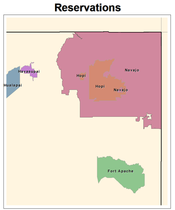
Our neighboring tribal nations are keen observers of weather and we work closely with them when they are interested in NWS support. Examples include rain gauges, hosting portable weather stations, educational programs and products for schools and community members and tribe-specific graphics.

Tribal Lands and Reservations across northern Arizona

Navajo Nation

  • Encompasses much of the Four Corners area of northeast Arizona including several national parks and monuments celebrating the history of the tribe.
  • Unlike most of Arizona, Navajo Nation does observe Daylight Savings Time.

Hualapai Reservation

  • Encompasses a large area of the western Grand Canyon, including the Grand Canyon West tourist center.
  • Much of the area is only accessible by long hikes or driving on dirt roads.

Havasupai Reservation

  • The reservation is located on a large tributary on the south side of the Colorado River, not accessible by road.
  • The isolated community of Supai Village, located within Havasu Canyon, has become a popular hiking destination over the past several years.

Hopi Reservation

  • The reservation is located in Coconino and Navajo counties, spanning more than 1.5 million acres, with 12 different villages.
  • Old Oraibi is the longest, continuously inhabited town in the United States.

White Mountain Apache Tribe - Fort Apache Reservation

  • The reservation covers 1.67 million acres in east-central Arizona with a wide range in elevation of 2,600 feet in the Salt River Canyon to over 11,400 feet at the top of Mount Baldy.
  • Currently, the tribe consists of roughly 16,000 members.

Yavapai-Prescott Reservation

  • The tribe is located in central and western Arizona.
  • Currently, the tribe consists of roughly 160 members and covers less than 1,500 acres.

Kaibab Reservation

  • The reservation covers 121,000 acres spanning from north of the Grand Canyon up to the Arizona-Utah border.
  • Five tribal villages can be found throughout the reservation, along with one non-Indian community (Moccasin). Pipe Spring National Monument is also within the bounds of the reservation.

Tonto Apache Reservation

  • The tribe is located adjacent to Payson and covers 85 acres, making it the smallest reservation by land size in the state.
  • Roughly 150 members are enrolled in the tribe. Many of the members are under the age of 18 years old.

Yavapai-Apache Nation

  • Located within the Verde Valley, the tribe is made up of 5 communities: Tunlii, Middle Verde, Rimrock, Camp Verde, and Clarkdale.
  • Currently, there are nearly 2,500 tribal members.

Zuni Reservation

  • Much of the reservation is located across the state line in New Mexico, but a small piece of reservation resides in east-central Arizona to the southeast of Holbrook.
  • Most of the nearly 20,000 members that are enrolled with the tribe live in New Mexico.

Overview

The National Weather Service Flagstaff is tasked with forecast and warning responsibilities within Apache, Coconino, Navajo and Yavapai counties; along with the northern half of Gila County. These geographic areas, about the size of the state of Ohio, provide a diverse set of forecast zones and climates.

Weather and Climate Information

High Country and Mountains

  • Flagstaff Pulliam Airport receives an average of 90.1 inches of snow between October and May.
  • The record 24-hr snowfall at Flagstaff Pulliam Airport is 35.9 inches.
  • Winter conditions force the closure of the entire northern portion of Grand Canyon National Park and many roadways in local National Forests.
  • Typical summer high temperatures range from around 75 - 90 degrees Fahrenheit.

Valleys and Basins

  • Snow has been documented in the lowest elevations of the NWS Flagstaff forecast areas (around 2,000 feet MSL).
  • The record 24-hr snowfall at Phantom Ranch (located in the bottom of the Grand Canyon) is 10.0 inches.
  • The Little Colorado River Valley and downslope areas northeast of the White Mountains are some of the most consistently windy areas of the NWS Flagstaff forecast areas.
  • Typical summer high temperatures range from around 85 - 105 degrees Fahrenheit.

To learn more about northern Arizona weather, visit our Science Corner page!

Topographic Map and Recreational Opportunities in northern Arizona

Federal Public Lands

Canyon de Chelly National Monument

  • Numerous canyons where people have lived for nearly 5,000 years - longer than anyone has lived uninterrupted anywhere on the Colorado Plateau.
  • Co-managed with Navajo community members.

Montezuma’s Castle National Monument

  • One of the best preserved cliff dwellings in North America at 20 stories high, with stories carved into it of the Sinagua culture.

Sunset Crater Volcano National Monument

  • Cinder cone volcano which erupted around the year 1085 and shaped the area around Flagstaff as we know it today.

Agua Fria National Monument

  • The national monument covers around 71,000-acres and contains two mesas and the canyon of the Agua Fria River.

Tuzigoot National Monument

  • Look into the history of the Sinagua people from the rooftop of the Tuzigoot pueblo, adjacent to the Verde River.

Vermilion Cliffs National Monument

  • Located on the Colorado Plateau, this is a 294,000 acre monument containing the Paria Plateau, Vermilion Cliffs, Coyote Buttes, and Paria Canyon.

Walnut Canyon National Monument

  • The curved canyon walls, ancient cliff dwellings, and pueblos feature signs of past life from several hundred years ago.

Wupatki National Monument

  • Several ancient pueblos can be seen across the miles of prarie land where life still thrives.

Grand Canyon National Park

  • A breath-taking canyon that is 277 river miles (446 km) long, up to 18 miles (29 km) across, and a mile (1.6 km) deep.

Petrified Forest National Park

  • Petrified logs with vivid colors are seen throughout this Park, with a section of the Painted Desert also within the bounds of Petrified Forest National Park.

Glen Canyon National Recreation Area

  • Stretching hundreds of miles from northern Arizona into southern Utah, this recreation area provides scenic vistas, geologic wonders, and a look back into human history.

State Public Lands

Jerome State Historic Park

  • Perched on the slopes of Cleopatra Hill, Jerome offers great panoramic views of the Verde Valley and a rich history as a mining town.

Riordan Mansion State Historic Park

  • The mansion was built in 1904 for two Riordan families in Flagstaff and is one of the best examples of American Arts and Crafts-style architecture still open and accessible to the public.

Fort Verde State Historic Park

  • This was a base for US Army scouts and soldiers led by General Crook in the 1870s and 1880s with three historic house museums on the property.

Dead Horse Ranch State Park

  • The park was named after the Ireys family who were ranch hunting in the 1940s and came across this property which had a dead horse laying in front of it. When the family sold the property in 1973, a condition of the sale was to rename the ranch and the surrounding property to Dead Horse Ranch.

Granite Mountain Hotshots Memorial State Park

  • The park is a place to remember the tragedy that took place on June 30, 2013 when nineteen members of the Granite Mountain Hotshot Firefighters died fighting the Yarnell Hill Fire.

Homolovi State Park

  • Four major pueblos and numerous smaller structures stand in this state park that sits along the banks of the Little Colorado River. The oldest sites are estimated to date back to AD 620. The park opened to the public in 1993.

Red Rock State Park

  • A 286 acres nature preserve that features Oak Creek and a wide variety of plants and wildlife.

Slide Rock State Park

  • Located in Oak Creek Canyon, this 43-acre historic apple farm provides historic cabins and the ability to take a dip into Oak Creek.

Tonto Natural Bridge State Park

  • The park includes the historic Goodfellow Lounge, built in 1927 which includes lodging for park guests. Four hiking trails run through the park, each less than ½ of a mile long.

Fool Hollow Lake Recreation Area

  • A popular camping and recreation area named after Thomas Jefferson Adair who moved to the area to camp in 1885. The locals at the time said only a fool would try to farm there, hence the eventual name of Fool Hollow Lake.