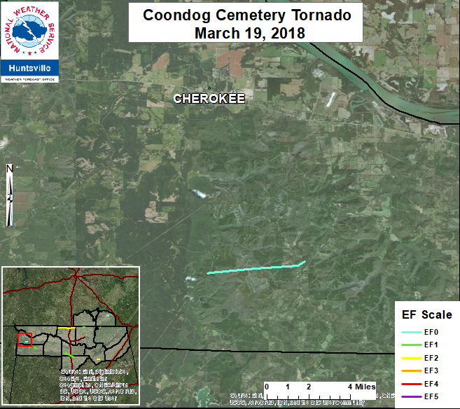
Coondog Cemetery
Colbert County, AL
| Date |
March 19, 2018 |
| Start Time (Local) |
5:05 PM CDT |
| End Time (Local) |
5:15 PM CDT |
| Start Location |
8 S Cherokee |
| End Location |
9 SSE Cherokee |
| Start Lat./Long. |
34.6291,-87.9681 |
| End Lat./Long. |
34.6372, -87.901 |
| EF Rating |
EF-0 |
| Est. Peak Winds |
70 mph |
| Path Length |
3.9 miles |
| Max Width |
120 yards |
| Injuries/Deaths |
0/0 |
|
Summary:
A damage assessment team from University of Alabama-Huntsville observed damage associated with a weak tornado in Southwest Colbert County. The assessment was verified by NWS Huntsville meteorologists. From UAH: The first area of damage was along Coondog Cemetery Rd. where a large pine tree was uprooted and fell South of due East and other trees losing branches around it. The tornado then crossed Coondog Cemetery Rd. moving into a region of extensive clear cutting and no open access. The next and more extensive damage area was along Mt. Mills Rd. Several large trees were observed uprooted in a ravine on the west side of Mt. Mills Rd., and more uprooted trees were found on a property on the SE corner of Mt. Mills Rd. and Bald Knob Rd. The last damage was found on the east end of the property, with another tree uprooted and limbs down. No damage was noted along Hwy 247.
|
Track Map
|
|
| |
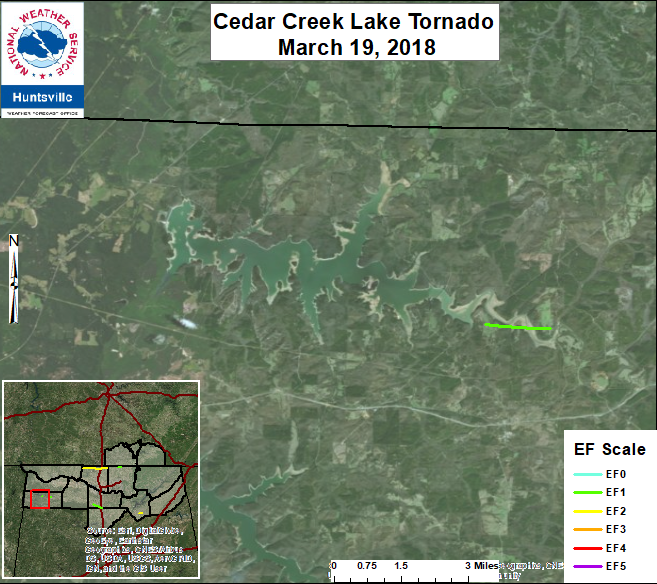
Cedar Creek, AL
Franklin County, AL
| Date |
March 19, 2018 |
| Start Time (Local) |
5:10 PM CST |
| End Time (Local) |
5:16 PM CDT |
| Start Location |
8 W Russellville |
| End Location |
7 W Russellville |
| Start Lat./Long. |
34.5107,-87.8727 |
| End Lat./Long. |
34.5092, -87.8516 |
| EF Rating |
EF-1 |
| Est. Peak Winds |
100 mph |
| Path Length |
1.21 miles |
| Max Width |
100 yards |
| Injuries/Deaths |
0/0 |
|
Summary:
A tornado touched down along Jacinto Road in the Belgreen community at EF-0 strength, with winds around 70 mph. A grove of softwood Cedar trees were snapped as the tornado crossed into a wooded area and moved east. The tornado further intensified as it approached Auburn Rd. There, a mobile home was sideswiped by the tornado. The roof and siding of the mobile home was partially damaged and the window was blown out. A very large pine tree was uprooted and a barn was completely destroyed. It was here that the tornado likely reached maximum strength around 90 to 100 mph. The tornado descended a steep bluff and crossed a narrow section of Cedar Creek Lake, snapping and uprooting numerous soft and hardwood trees. The tornado likely reached its greatest width at around 100 yards. On the opposite side of the lake, a covered boat slip was completely destroyed. Numerous trees and uprooted and snapped off and the siding and roof of three single family homes. The tornado weakened as it crossed Hwy 41. It knocked over another grove of cedars and caused very minor EF-0 damage to the siding of a house. The tornado lifted in the a heavily forested area along the far eastern edge of Cedar Creek Lake.
|
Track Map
|
|
| |
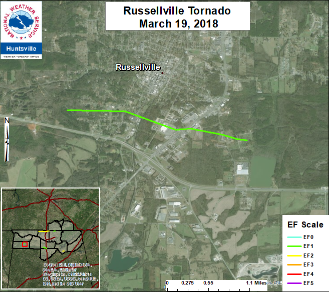
Russellville, AL
Franklin County, AL
Click here for more details.
| Date |
March 19, 2018 |
| Start Time (Local) |
5:21 PM CDT |
| End Time (Local) |
5:30 PM CDT |
| Start Location |
1.0 WSW Russellville |
| End Location |
1.0 SE Russellville |
| Start Lat./Long. |
34.4988, -87.7476 |
| End Lat./Long. |
34.4929, -87.7129 |
| EF Rating |
EF-1 |
| Est. Peak Winds |
90 mph |
| Path Length |
2.05 miles |
| Max Width |
200 yards |
| Injuries/Deaths |
0/0 |
|
Summary:
This tornado touched down in the Reedtown section of Russellville with EF-0 intensity, containing winds of 65-70 mph. The tornado caused minor roof and siding damage to a few single family homes. The tornado strengthened quickly to low-end EF-1 as it knocked the chimney of a house and caused more extensive damage to the siding and metal roof of another. The tornado likely reached maximum intensify and width as it crossed Hwy 43 on the south side of Russellville. Here, the tornado was around 200 yards wide, with winds of 90 mph. A Waffle House restaurant had damage to its sign and roof. A warehouse and apartment complex also sustained some minor structural damage. The tornado then moved through a residential section of southeast Russellville, causing significant damage to a grove of pine and cedar trees and completely destroyed a small barn. However, only minor damage occurred at any of the one to two story homes, placing winds in the 80-90 mph range. The tornado then weakened further as it approached Hwy 42 east of Russellville and lifted near Sloss Lake Park.
|
Track Map
|
|
| |
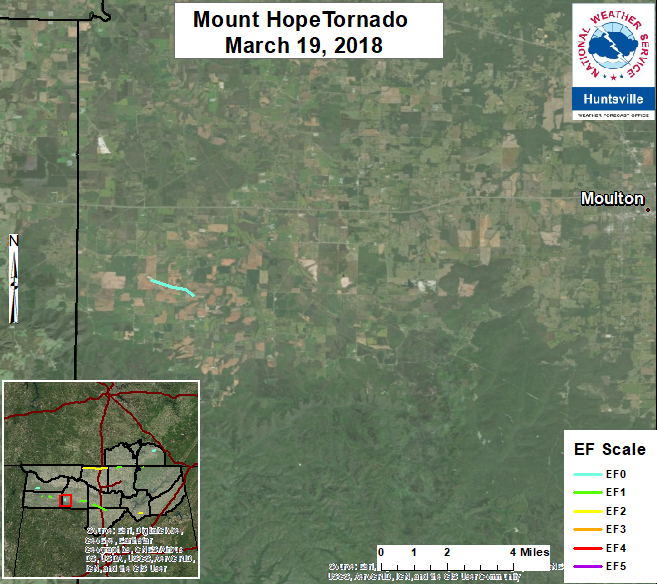
Mount Hope, AL
Lawrence County, AL
Click here for more details.
| Date |
March 19, 2018 |
| Start Time (Local) |
5:54 PM CDT |
| End Time (Local) |
5:56 PM CDT |
| Start Location |
11 N Pebble |
| End Location |
11 WSW Moulton |
| Start Lat./Long. |
34.4535, -87.4978 |
| End Lat./Long. |
34.447, -87.4794 |
| EF Rating |
EF-0 |
| Est. Peak Winds |
80 mph |
| Path Length |
1.16 miles |
| Max Width |
250 yards |
| Injuries/Deaths |
0/0 |
|
Summary:
A weak tornado touched down on Spruell Farm on County Roads 35/36 in western Lawrence County. At this location, several small fertilizer containers were blown over, and one was blown for more than 1000 yards to the east-southeast. Further east in Mount Hope, trees were uprooted and branches snapped along County Road 23 between Mount Hope Baptist Church and Mount Hope School. Minor damage was noted to the bleachers at Mount Hope School as they were dragged a couple of feet from their original location. EF-0 damage was assessed at these locations with a maximum wind here of 80 mph.
|
Track Map
|
|
| |
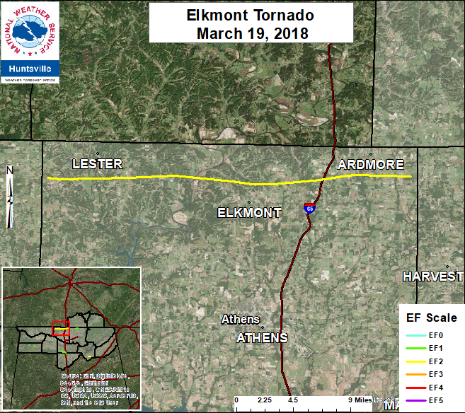
Elkmont/Ardmore, AL
Limestone County, AL
| Date |
March 19, 2018 |
| Start Time (Local) |
6:08 PM CDT |
| End Time (Local) |
6:46 PM CDT |
| Start Location |
4 SW Lester |
| End Location |
3 ESE Ardmore |
| Start Lat./Long. |
34.9572, -87.2049 |
| End Lat./Long. |
34.9589, -86.7922 |
| EF Rating |
EF-2 |
| Est. Peak Winds |
125 mph |
| Path Length |
23.54 miles |
| Max Width |
600 yards |
| Injuries/Deaths |
0/0 |
|
Summary:
The tornado initially touched down just east of the Lauderdale-Limestone county line near the intersection of Union Hill Road and Shelton Road. Nearly all of the damage in northwest Limestone County consisted of snapped or uprooted trees, in a swath extending across Salem Minor Hill Road, Leggtown Road, and the Elk River. Significant tree damage was noted along Alabama Highway 127 and Veto Road north of Elkmont, where likely hundreds of trees were snapped or uprooted. It was in this area where the tornado reached its maximum path width of 350 yards. The tornado continued east-northeast, narrowly missing the Saturn I rocket at the Alabama Welcome Center on Interstate 65. Tree damage continued on Hardiman Lane east of I-65, but roof damage also occurred to single-family homes. Similar damage was observed on Puckett Lane and Oak Grove Road. There is evidence (both from radar and ground surveys) to suggest that the tornado had multiple vortices between Oak Grove Road and Valley Drive, as there are two distinct damage paths in this area. Again, much of the damage was to trees and roofs of single- family and manufactured homes, as well as small sheds and barns. The most severe damage by far occurred along Alabama Highway 251 and Gatlin Road, where one or two houses had their roofs and roofing structures almost completely torn off, and several more had most of their shingles torn off. Fortunately the residents had taken shelter in a nearby basement and none were injured. The tornado weakened quickly, snapping and uprooting trees as it moved across Mitchell Loop, Old Schoolhouse Road, and Alabama Highway 53. No evidence of damage was found east of Highway 53. Damage in Madison County is associated with a separate tornado that will be summarized in another statement.
|
Track Map
|
|
| |
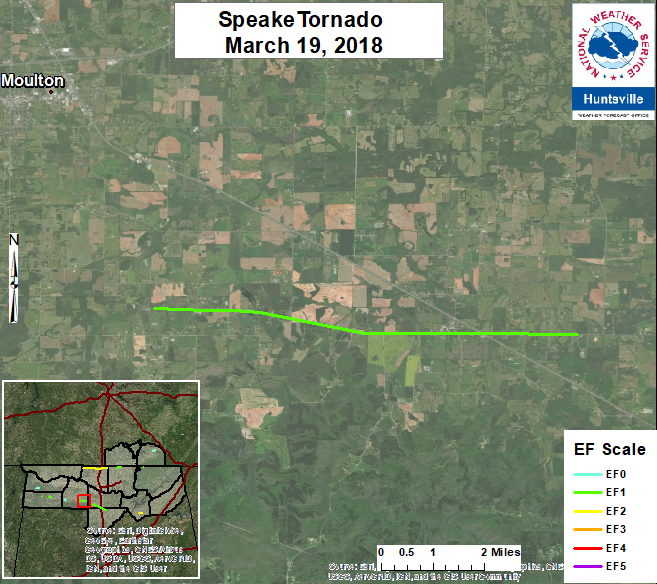
Speake, AL
Lawrence County, AL
| Date |
March 19, 2018 |
| Start Time (Local) |
6:18 PM CDT |
| End Time (Local) |
6:22 PM CDT |
| Start Location |
4 WNW Speake |
| End Location |
Speake |
| Start Lat./Long. |
34.4234, -87.2523 |
| End Lat./Long. |
34.4161, -87.1341 |
| EF Rating |
EF-1 |
| Est. Peak Winds |
100 mph |
| Path Length |
6.8 Miles |
| Max Width |
100 yards |
| Injuries/Deaths |
0/0 |
|
Summary:
Further south and east of Moulton, damage was again noted in the community of Speake. One cluster of damage occurred near the intersection of Highway 36 and County Road 183. Farther east-southeast, trees were snapped and uprooted along the path near Speake School on Highway 36 just south of the intersection of County Road 81 and Highway 157. Due to the trees snapped at this location, the tornado was at its peak intensity, EF-1, with winds around 100 mph noted. Tornado width was approximately 50 yards. From there, the tornado lifted just SE of Speake, continuing on to eventually produce another tornado across the Morgan County line. No damage was noted from Speake to the Lawrence/Morgan County line as the supercell cycled.
|
Track Map
|
|
| |
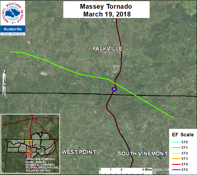
Massey, AL
Morgan County, AL
| Date |
March 19, 2018 |
| Start Time (Local) |
6:29 PM CDT |
| End Time (Local) |
6:59 PM PM CDT |
| Start Location |
7 SW Hartselle |
| End Location |
4 NNE South Vinemont |
| Start Lat./Long. |
34.3675, -87.0404 |
| End Lat./Long. |
34.2785, -86.8213 |
| EF Rating |
EF-1 |
| Est. Peak Winds |
100 mph |
| Path Length |
14.18 miles |
| Max Width |
550 yards |
| Injuries/Deaths |
0/0 |
|
Summary:
The Massey Tornado in Southern Morgan County was associated with the long lived parent supercell that migrated eastward from the AL/MS state line. The damage assessment team consisting of NWS Huntsville and Morgan County EMA concluded that the impacts in Southern Morgan County were consistent with an EF-1 tornado. Widespread tree damage (snapped and uprooted) was observed across the path as the tornado and parent supercell dove southeast from near the CR55/Summerford Rd area to Wilhite Rd (east of I 65 on the the Cullman/Morgan Co border). Only structure damage to note was a couple small farm structures and sheds that were heavily damage or destroyed adjacent to Evergreen Rd, consistent with EF-1 damage. Damage indicators became more widely scattered as it approached I-65, but several trees were observed damaged along Wilhite Rd. The tornado was estimated to lift near the Morgan/Cullman County line.
|
Track Map
|
|
| |
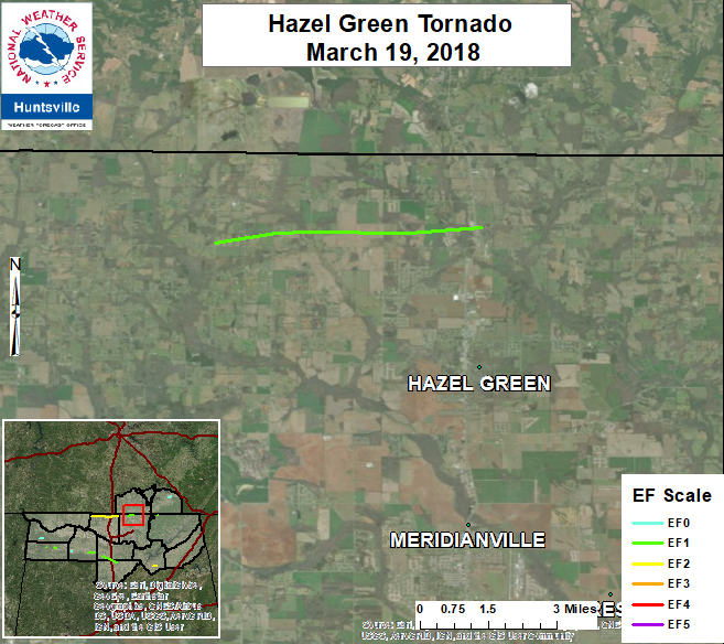
Hazel Green, AL
Madison County, AL
| Date |
March 19, 2018 |
| Start Time (Local) |
6:58 PM CDT |
| End Time (Local) |
7:04 PM CDT |
| Start Location |
5 NW Hazel Green |
| End Location |
3 N Hazel Green |
| Start Lat./Long. |
34.9631, -86.6509 |
| End Lat./Long. |
34.9682, -86.5665 |
| EF Rating |
EF-1 |
| Est. Peak Winds |
105 mph |
| Path Length |
4.81 miles |
| Max Width |
150 yards |
| Injuries/Deaths |
0/0 |
|
Summary:
The tornado began near the intersection of Bobo Section Road and Delynn Drive west of Hazel Green, where multiple trees were uprooted, some of which fell onto nearby homes. Damage continued eastward along Bobo Section Road, with multiple trees snapped and uprooted, and a few sheds or farm outbuildings heavily damaged. Minor tree and roof damage was observed along Frank Patterson Road, although it is likely that this damage was associated with the rear-flank downdraft of the storm. The most notable damage occurred once the tornado reached Highway 231, where the tornado hit a building supply yard and nearby houses. Almost a quarter of the shingles were removed from a single family home and a nearby tree was twisted apart. At the building supply store, metal roofing and siding covering the supplies were completely removed and the underlying wooden support structure broken. The metal roofing was strewn across the street and into a field. Security video footage confirms the presence of a circulation but the tornado appears to have been rain-wrapped. The tornado caused further shingle damage and snapped more trees across the highway near Walls Road and Leigh Ann Road, but the damage appears to diminish quickly beyond this point.
|
Track Map
|
|
| |
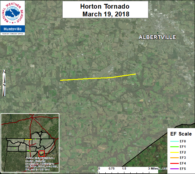
Horton, AL
Marshall County, AL
| Date |
March 19, 2018 |
| Start Time (Local) |
7:26 PM CDT |
| End Time (Local) |
7:41 PM PM CDT |
| Start Location |
4 NNE Douglas |
| End Location |
3 SSW Albertville |
| Start Lat./Long. |
34.2216, -86.2939 |
| End Lat./Long. |
34.2271, -86.2286 |
| EF Rating |
EF-2 |
| Est. Peak Winds |
112 mph |
| Path Length |
3.76 miles |
| Max Width |
690 yards |
| Injuries/Deaths |
0/0 |
|
Summary:
The Horton Tornado in Southern Marshall County was associated with the long lived parent supercell that migrated eastward from the AL/MS state line. The damage assessment team, consisting of NWS Huntsville and Marshall County EMA, noted the beginning of the damage west of Old Oneota Rd and Dixie Dale Rd. Numerous trees were either snapped or uprooted along and adjacent to Old Oneota Rd, indicative of 90 mph. More significant damage was noted on the west side of Ole Oneota Rd were two chicken houses and a barn were destroyed. The team determined winds to be 112 mph, or a low-end EF- 2. The second set of chicken houses destroyed occurred near Oneota Cutoff Rd, however these were not as heavily as damaged. As the tornado tracked due east toward Hwy 75 , he most prevalent damage was snapped or uprooted trees. On the west side of Hwy 75, damage was noted to a weak farm building. Damage was not observed on the east side of the Hwy or at Albertville Regional Airport. However, numerous snapped or uprooted trees were observed along White Oak Road and east toward Whitesville Rd. Structure damage was recorded on Whitesville Rd to a third set of chicken houses, but the damage was downgraded due to the fact the doors were open. The tornado was estimated to lift just east of Whitesville Rd before Walnut St.
|
Track Map
|
|
| |
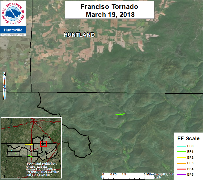
Franciso, AL
Jackson County, AL
| Date |
March 19, 2018 |
| Start Time (Local) |
7:30 PM CDT |
| End Time (Local) |
7:36 PM CDT |
| Start Location |
6 SSE Huntland |
| End Location |
6 SSE Huntland |
| Start Lat./Long. |
34.9682, -86.2307 |
| End Lat./Long. |
34.9692, -86.2217 |
| EF Rating |
EF-1 |
| Est. Peak Winds |
86 mph |
| Path Length |
0.53 miles |
| Max Width |
200 yards |
| Injuries/Deaths |
0/0 |
|
Summary:
The parent supercell that produced tornado damage in Limestone and Madison County also produced damage in far northwest Jackson County. A NWS Huntsville damage assessment team confirmed EF-1 damage near Hwy 25 between mile markers 25 and 26. The primary damage indicators were trees on both sides of highway. The beginning of the tornado damage was observed on the west side of Hwy 25 on the downslope of an east-facing ridge. An extensive area of downed trees was noted along the slope as it approached the valley. As the tornado tracked ENE back up a west-facing slope along Hwy 25, trees were uprooted across the road and a distinctive cyclonic circulation approx. 200 yd wide was observed. Due to inaccessible locations, the damage assessment team approximated the touchdown near the mid-slope of the ridge west of Hwy 25 and the lifting point on lower half of the slope on the east side of Hwy 25.
|
Track Map
|
|
| |
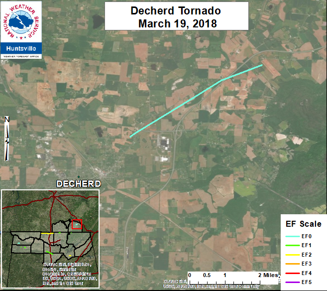
Decherd, TN
Franklin County, TN
| Date |
March 19, 2018 |
| Start Time (Local) |
7:50 PM CDT |
| End Time (Local) |
7:55 PM CDT |
| Start Location |
2 NE Decherd |
| End Location |
5 NE Decherd |
| Start Lat./Long. |
35.2257, -86.0669 |
| End Lat./Long. |
35.2552, -86.0127 |
| EF Rating |
EF-0 |
| Est. Peak Winds |
75 mph |
| Path Length |
3.69 miles |
| Max Width |
150 yards |
| Injuries/Deaths |
0/0 |
|
Summary:
NWS Huntsville survey team has confirmed weak tornado damage in Decherd area. Sporatic tree damage adjacent to the Hwy 50/64 connector (northwest of the Nissan Plant) was observed by the team. A few trees near the intersection of Old Alto Hwy and Hwy 50 were slightly uprooted or had large branches knocked down. The assessment team determined the damage was indicative of an EF-0 tornado with winds of 75 mph. The tornado tracked east-northeast along/adjacent to Old Alto Hwy and very minor, and widely scattered large tree branch damage was observed through the Gum Creek area.
|
Track Map
|
|
| |
Large Hail Reports
|
Additionally, numerous reports of extremely large hail occurred with these storms, below is an image of some of the larger hail reports that occurred across the area.
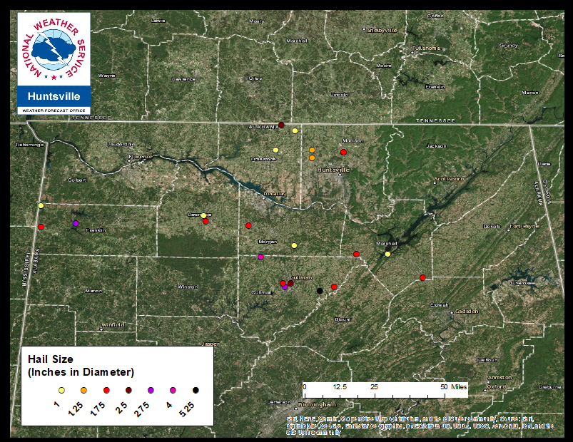
One of these hail stones was approximately 5.25 inches in diameter (a possible stare record). Data concerning this hailstone is being submitted to the National Climate Center for certification of a new state record hailstone. For more information about this click here.
|
| Back to the Top of the Page |
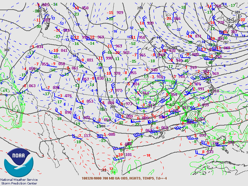
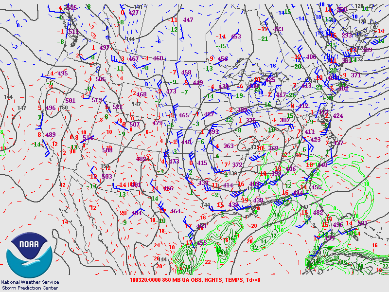
Upper Air Charts
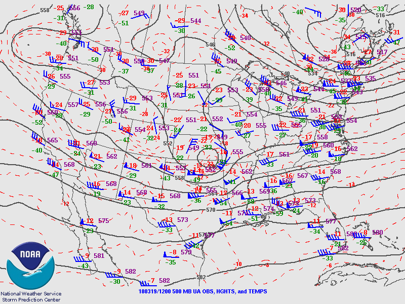
500mb Chart at 7am March 19th
|
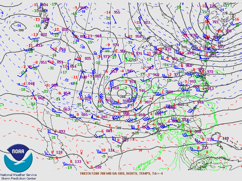
700mb Chart at 7am March 19th
|
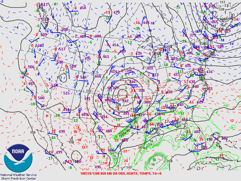
850mb Chart at 7am March 19th
|
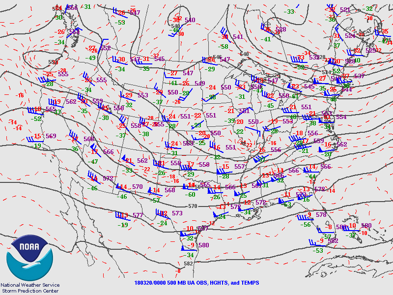
500mb Chart at 7pm March 19th
|
700mb Chart at 7pm March 19th
|
850mb Chart at 7pm March 19th
|
| Back to the Top of the Page |
SPC Outlooks
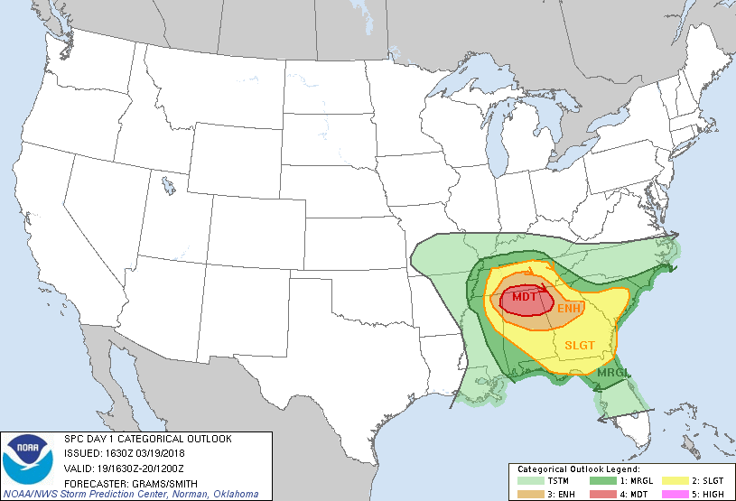
Day 1 Outlook
Issued 11:30am March 19th
|
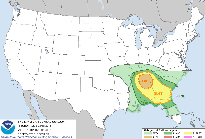
Day 2 Outlook
Issued 11:30am March 18th
|
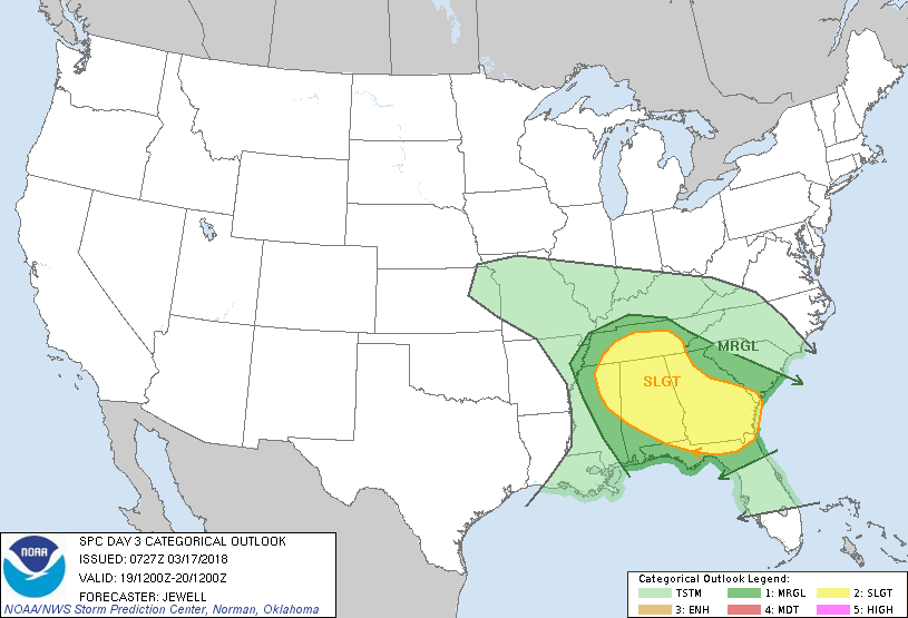
Day 3 Outlook
Issued 2:30am March 17th
|
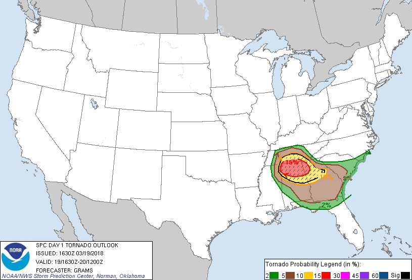
Day 1 Tornado Probability
Issued 11:30am March 19th
|
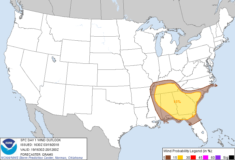
Day 1 Wind Probability
Issued 11:30am March 19th
|
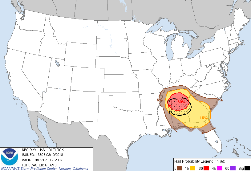
Day 1 Hail Probability
Issued 11:30 am March 19th
|
| Back to the Top of the Page |
Images

EF2 Damage near Gatlin Road from Ardmore Tornado (125 mph)
|

EF2 Damage near Gatlin Road from Ardmore Tornado (125 mph)
|

EF2 Damage near Old Oneonta Road from Horton Tornado (112 mph)
|
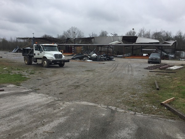
EF1 Damage to a warehouse from Hazel Green Tornado (105 mph)
|
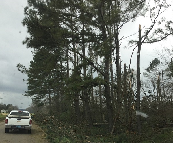
EF1 Damage to trees from Massey Tornado (100 mph)
|
EF1 Tree damage on Highway 36 from Speake Tornado (100 mph)
|
| Back to the Top of the Page |
|


 Local Radar
 Weather Map