Overview
A summary of the May 7th, 2024 tornadoes & severe weather across Indiana, Michigan, and Ohio.
Tornadoes
|
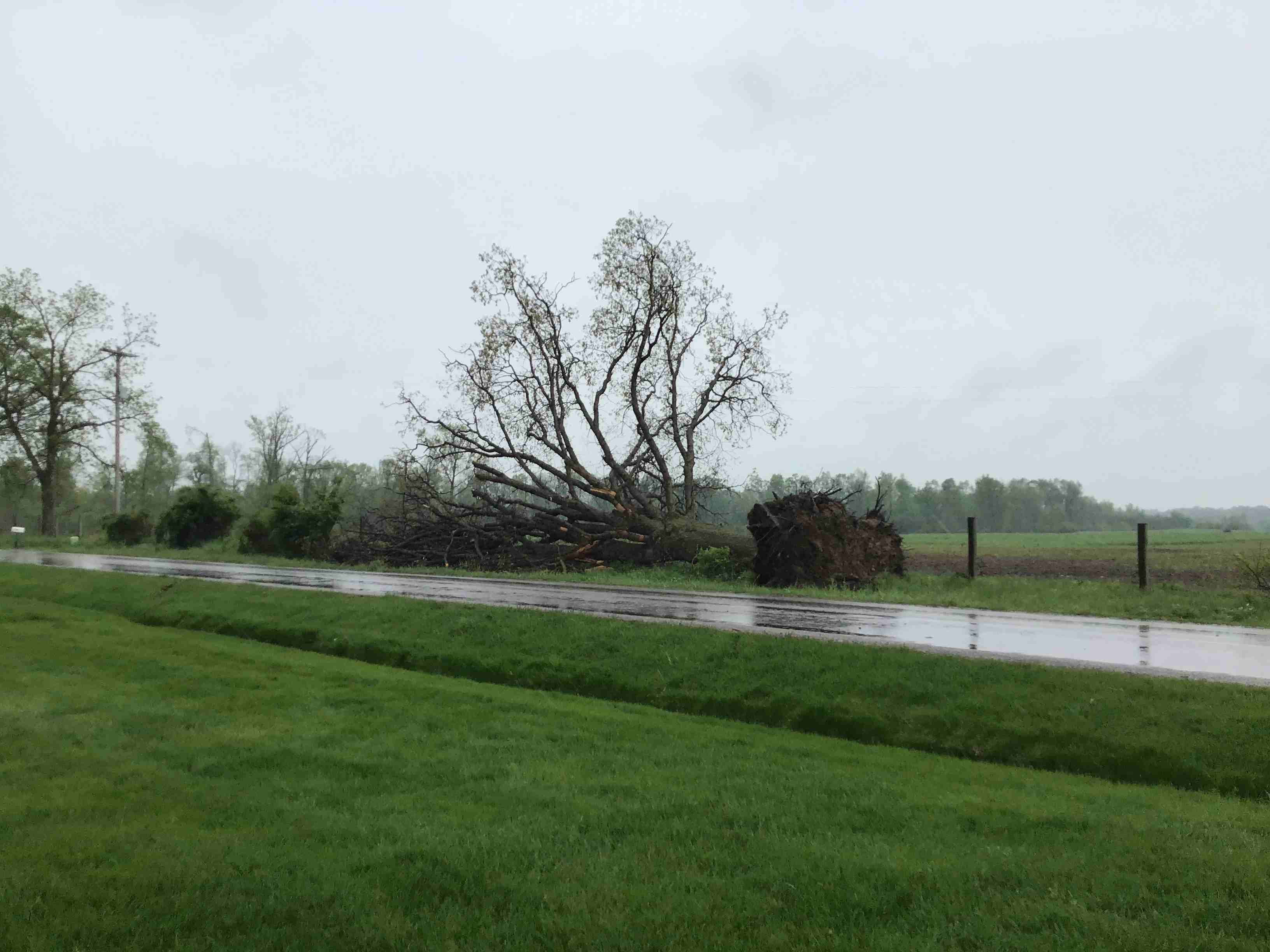
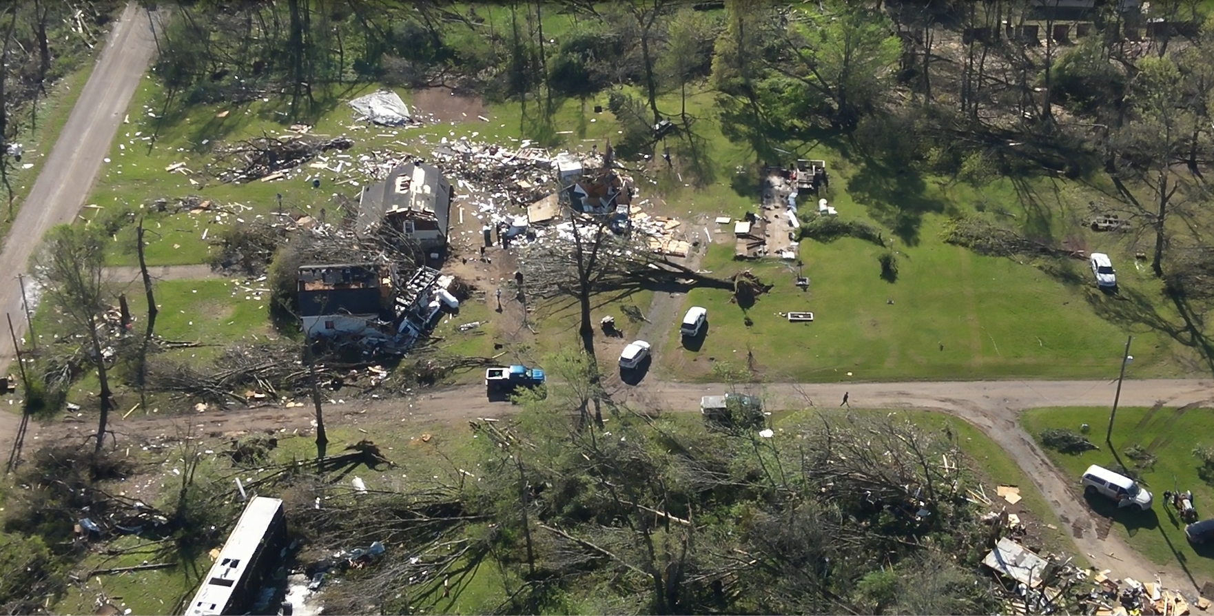
Tornado - Crooked Lake, IN
Track Map 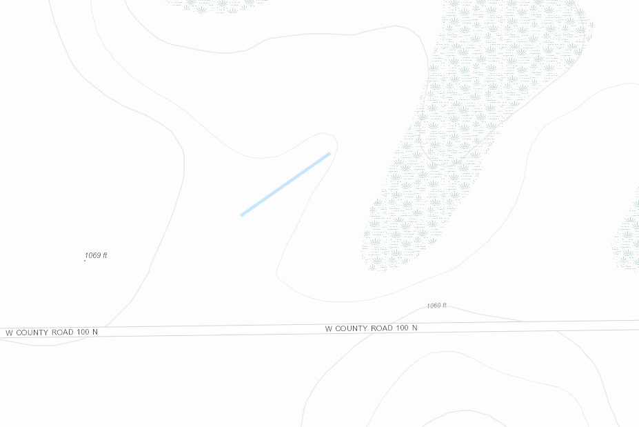  |
||||||||||||||||
|
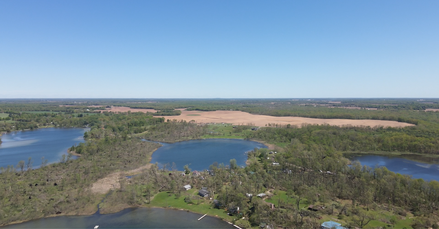
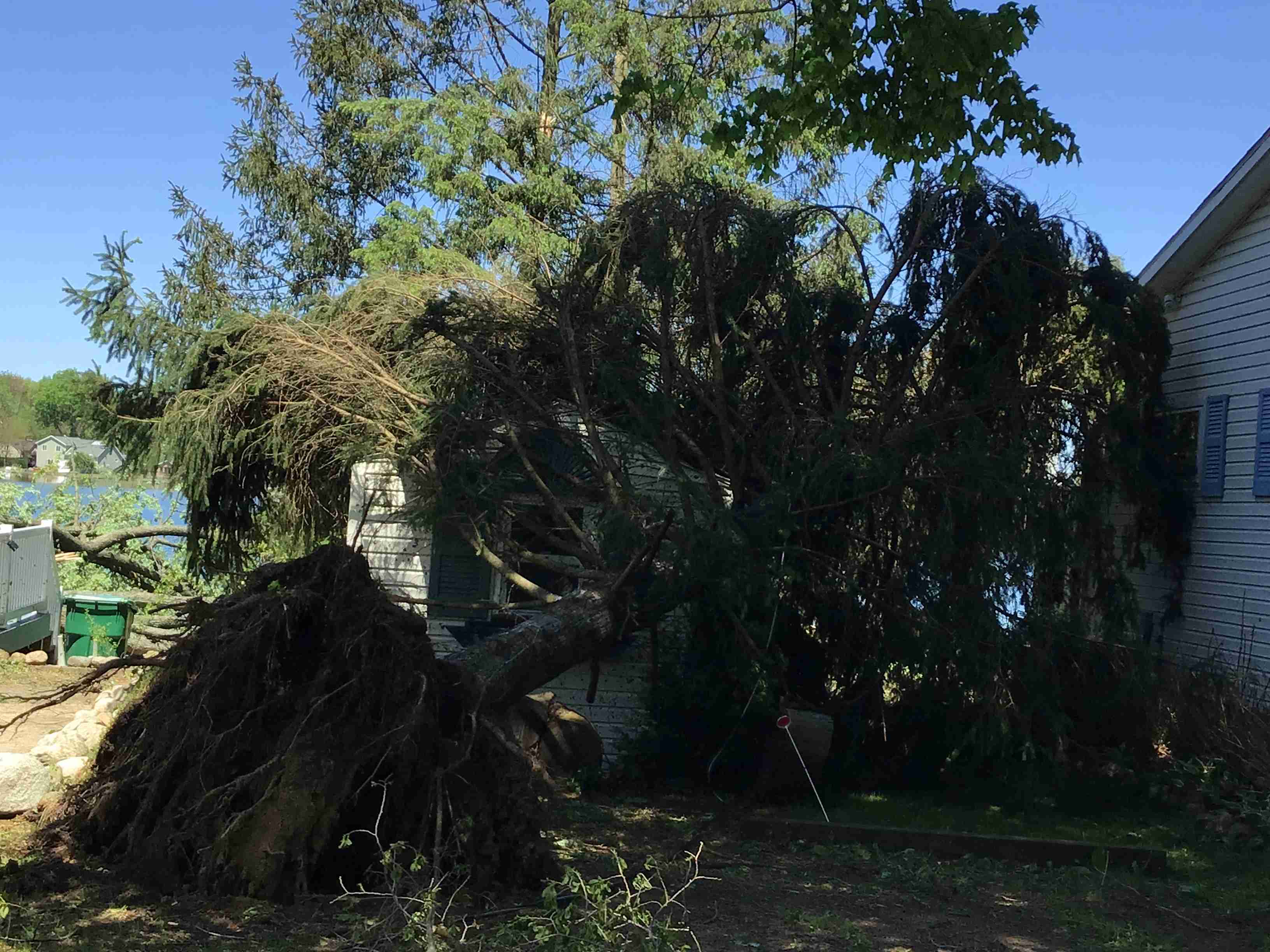
Tornado - Union Lake, MI
Track Map 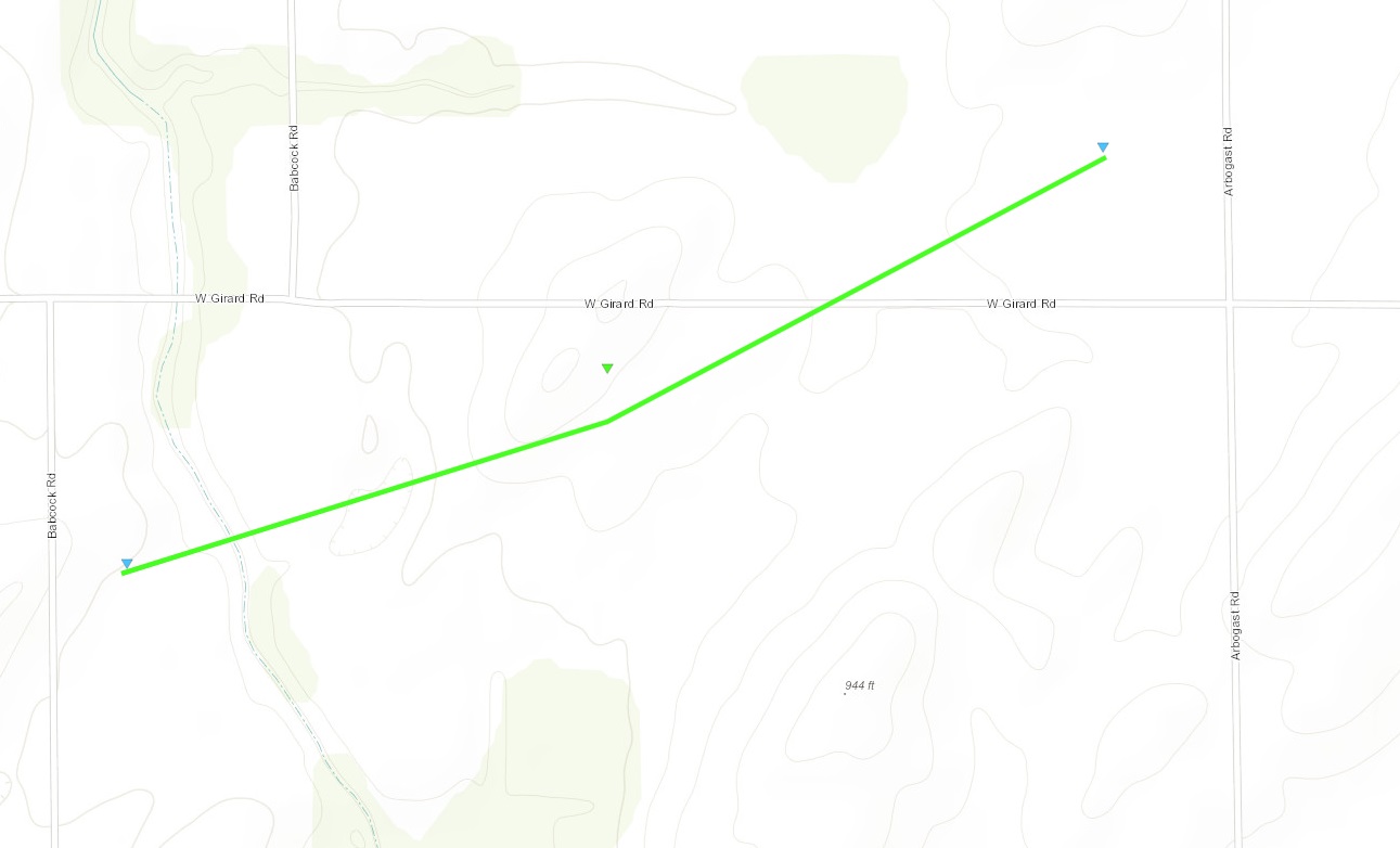 |
||||||||||||||||
|
||||||||||||||||
|
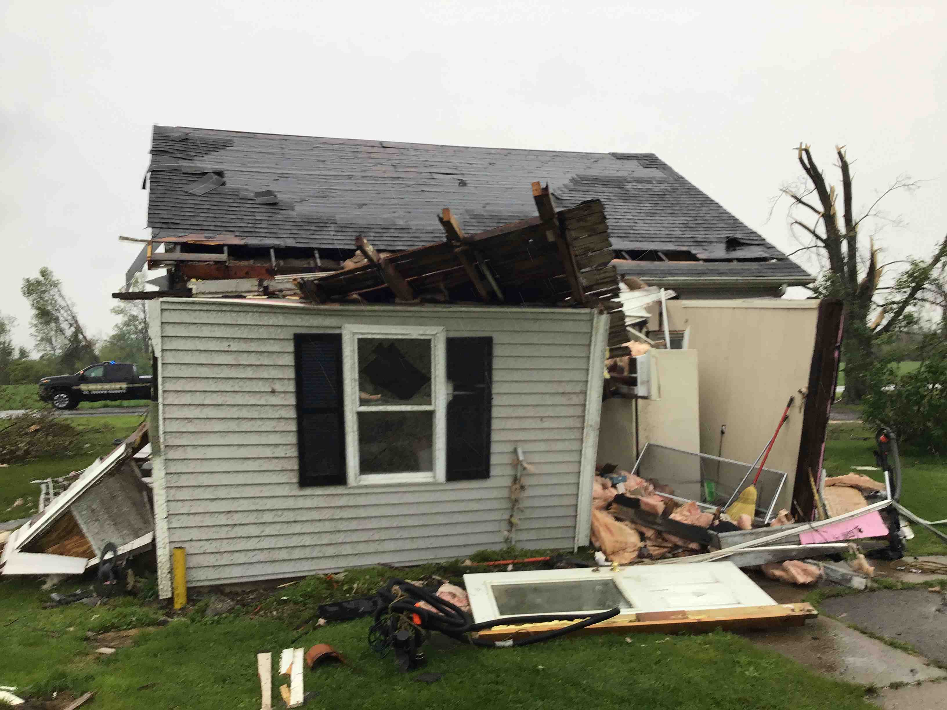
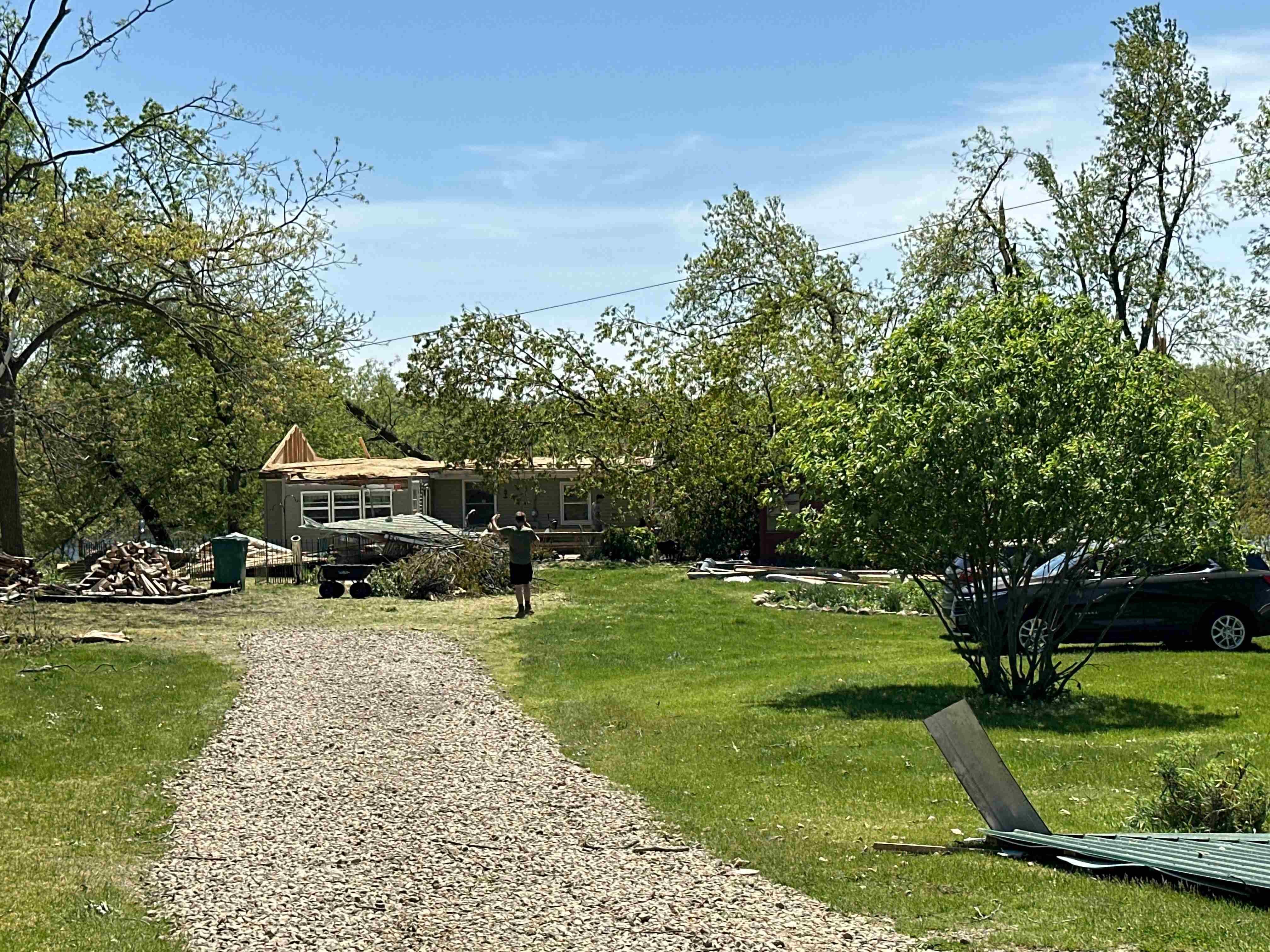
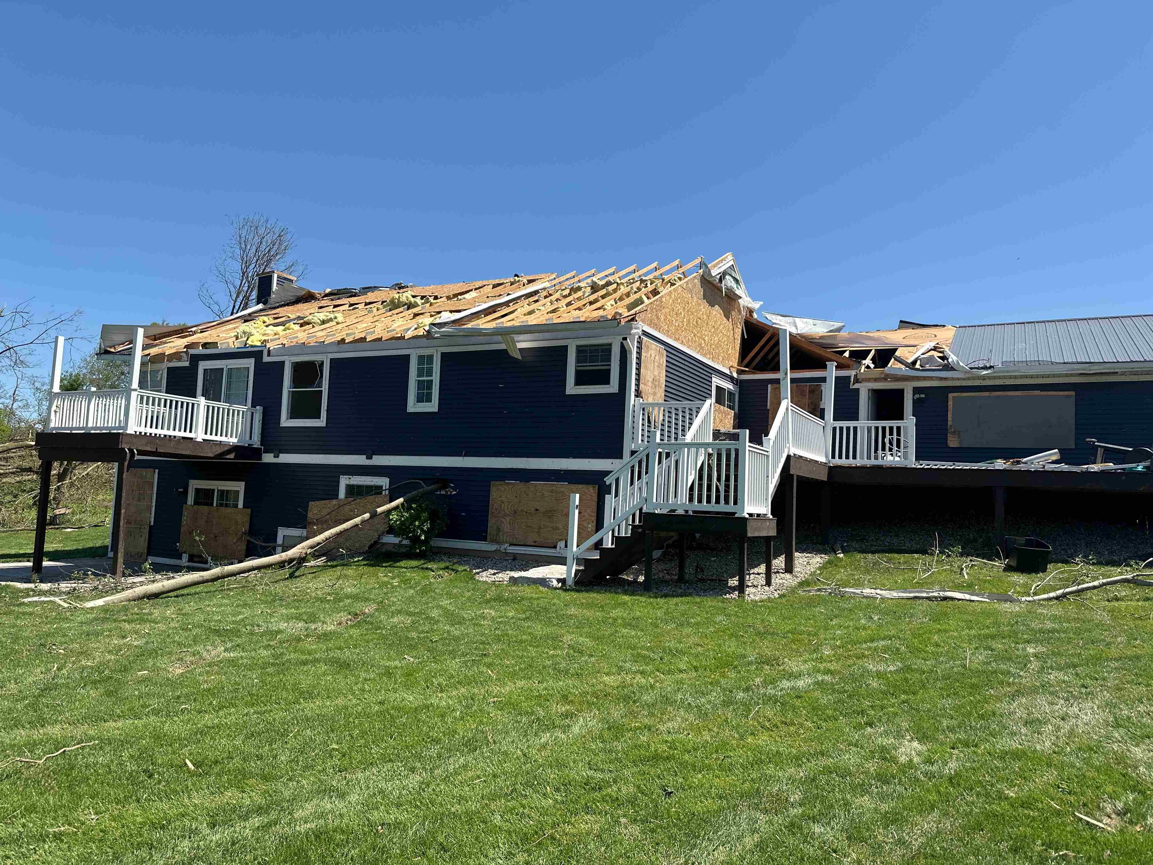
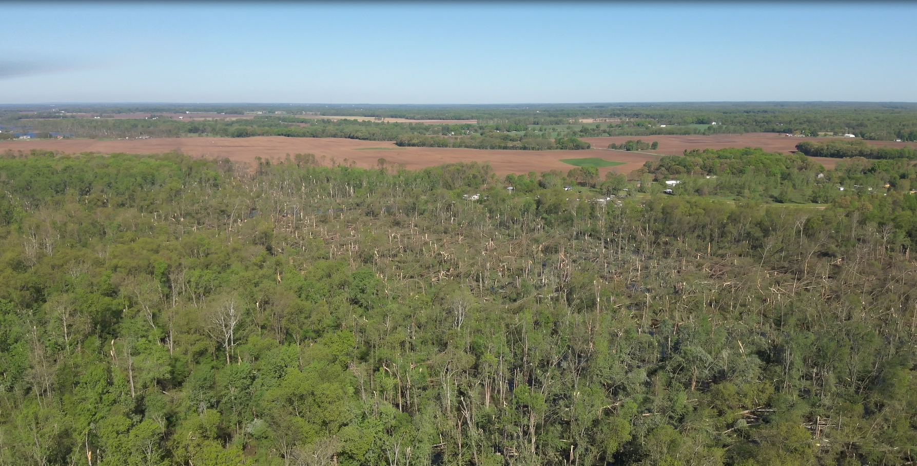
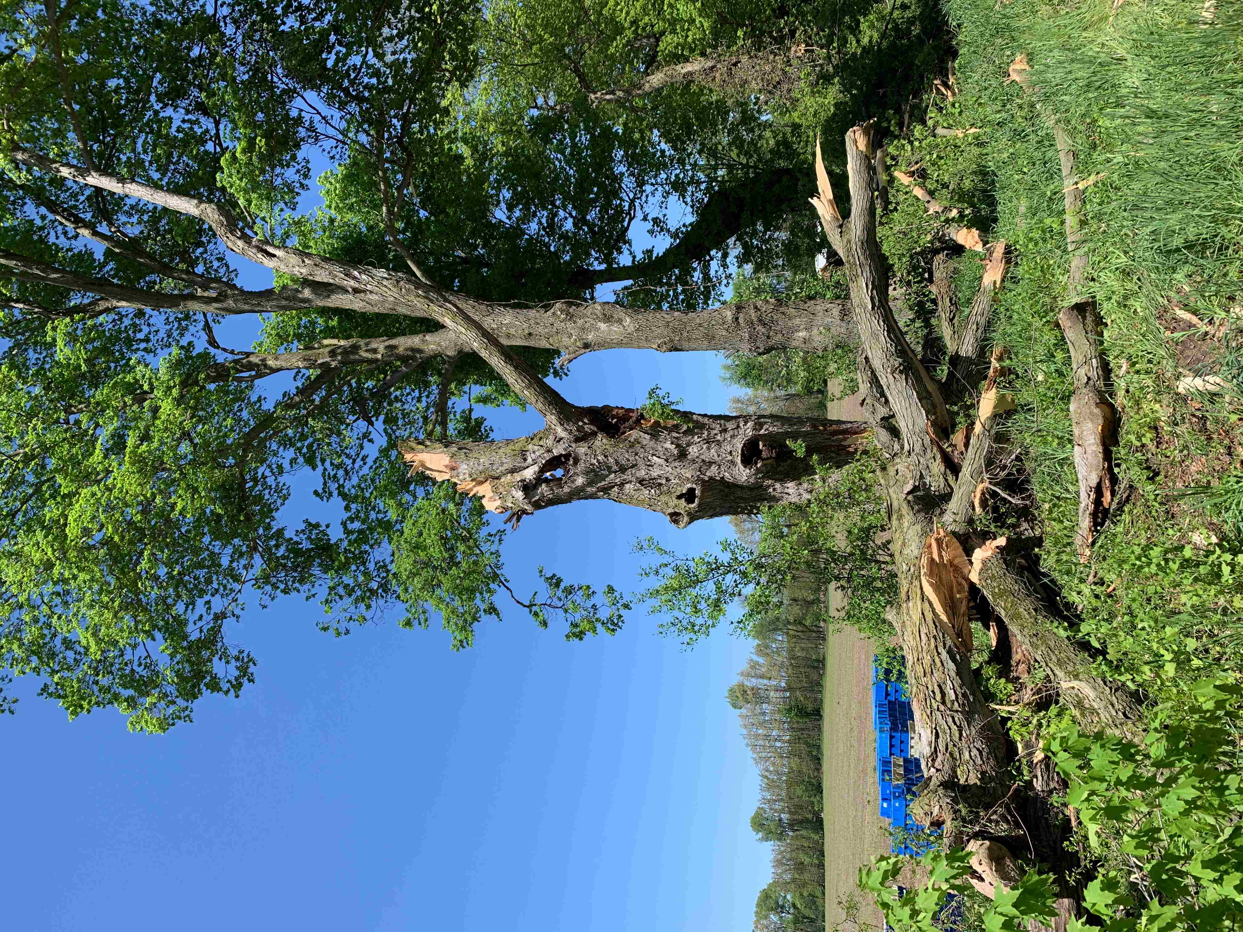
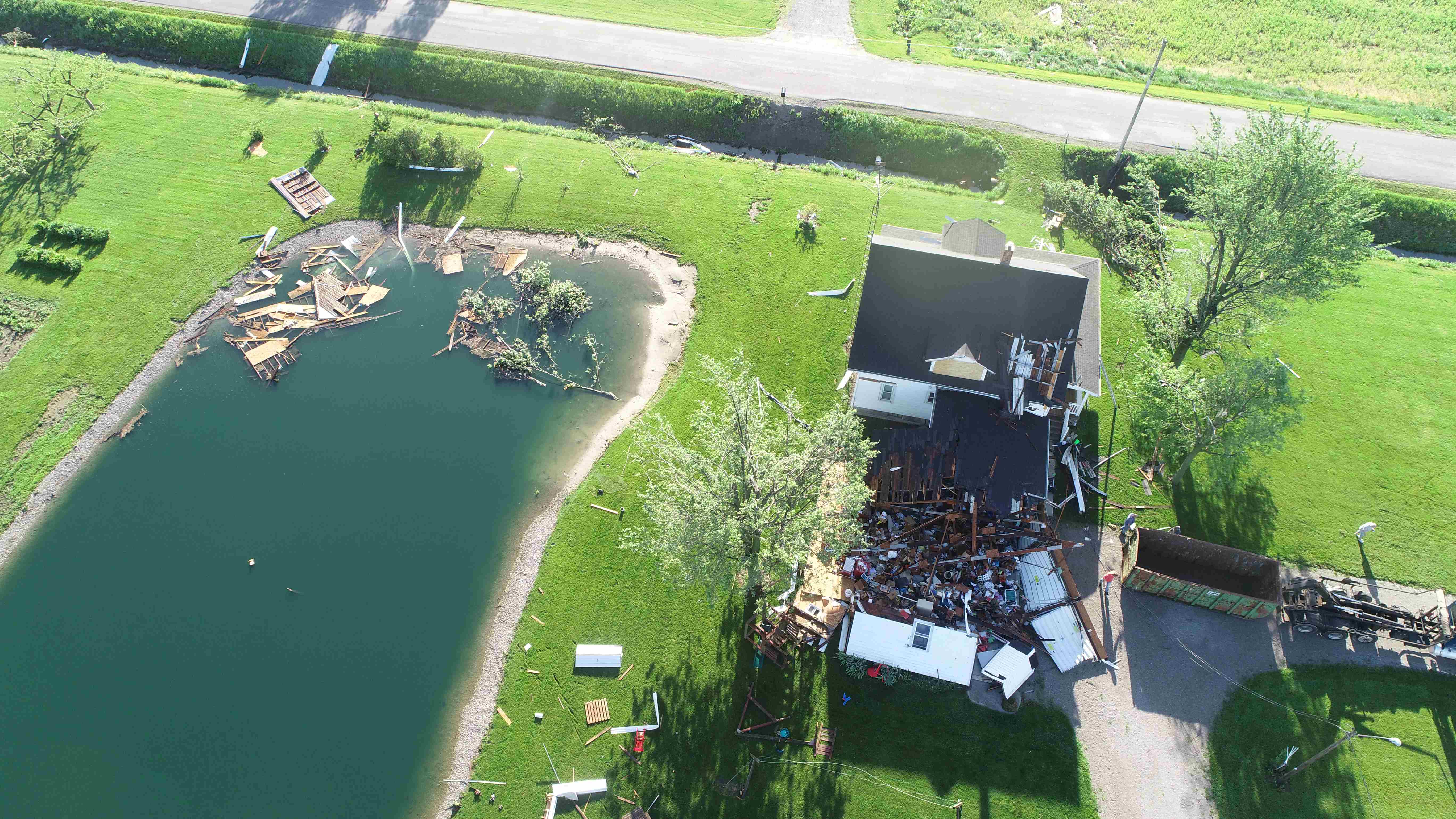
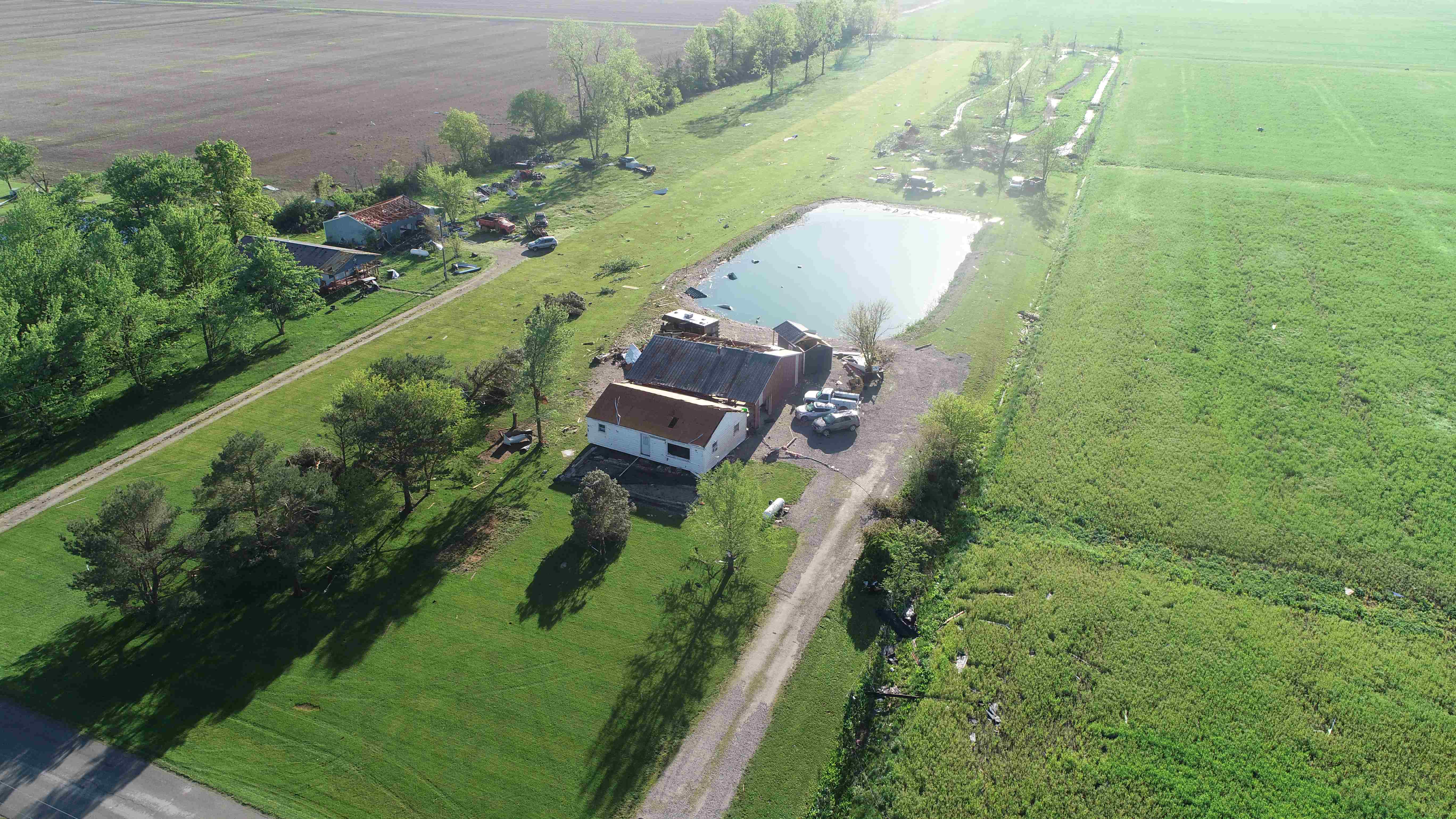
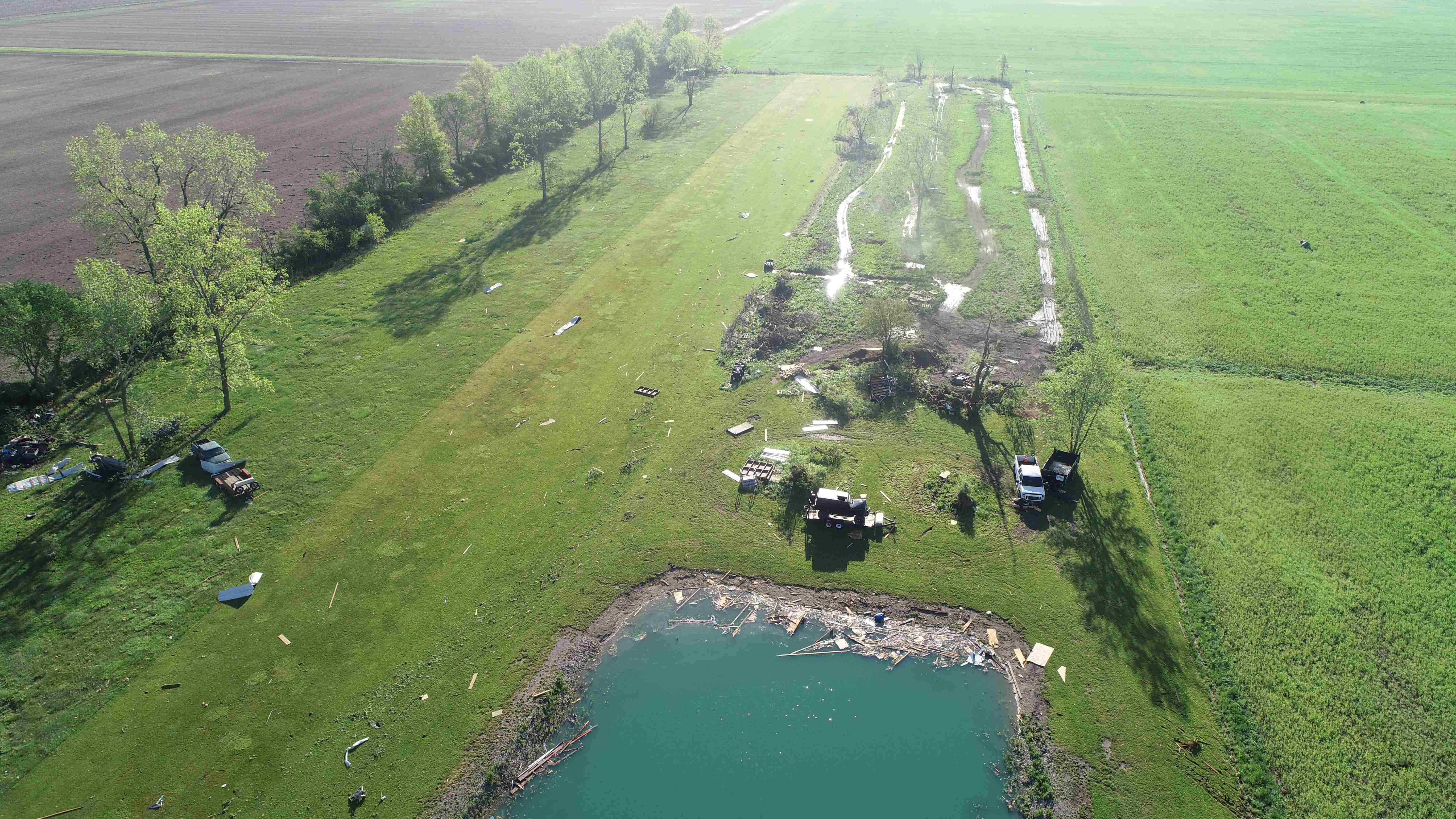
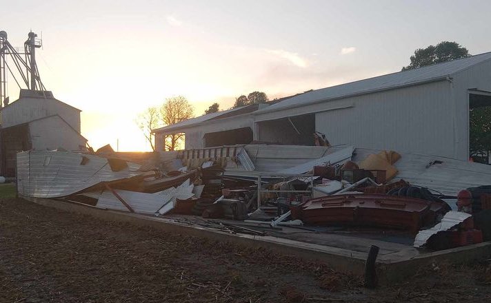
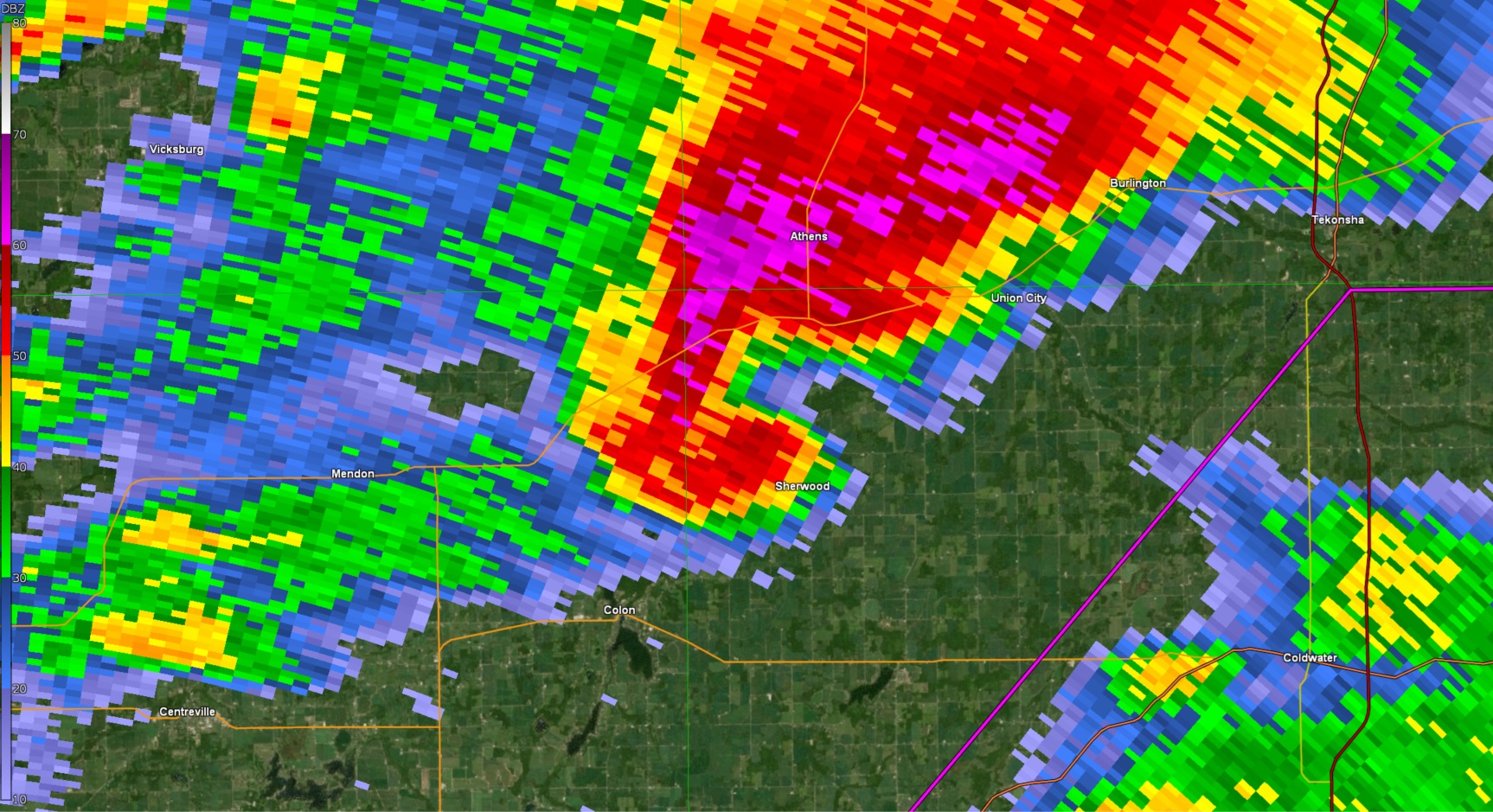
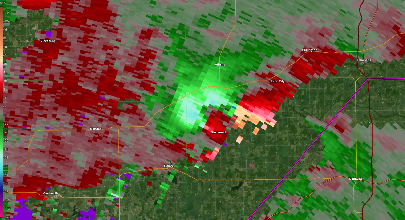
Tornado - Centreville-Colon-Sherwood, MI
Track Map 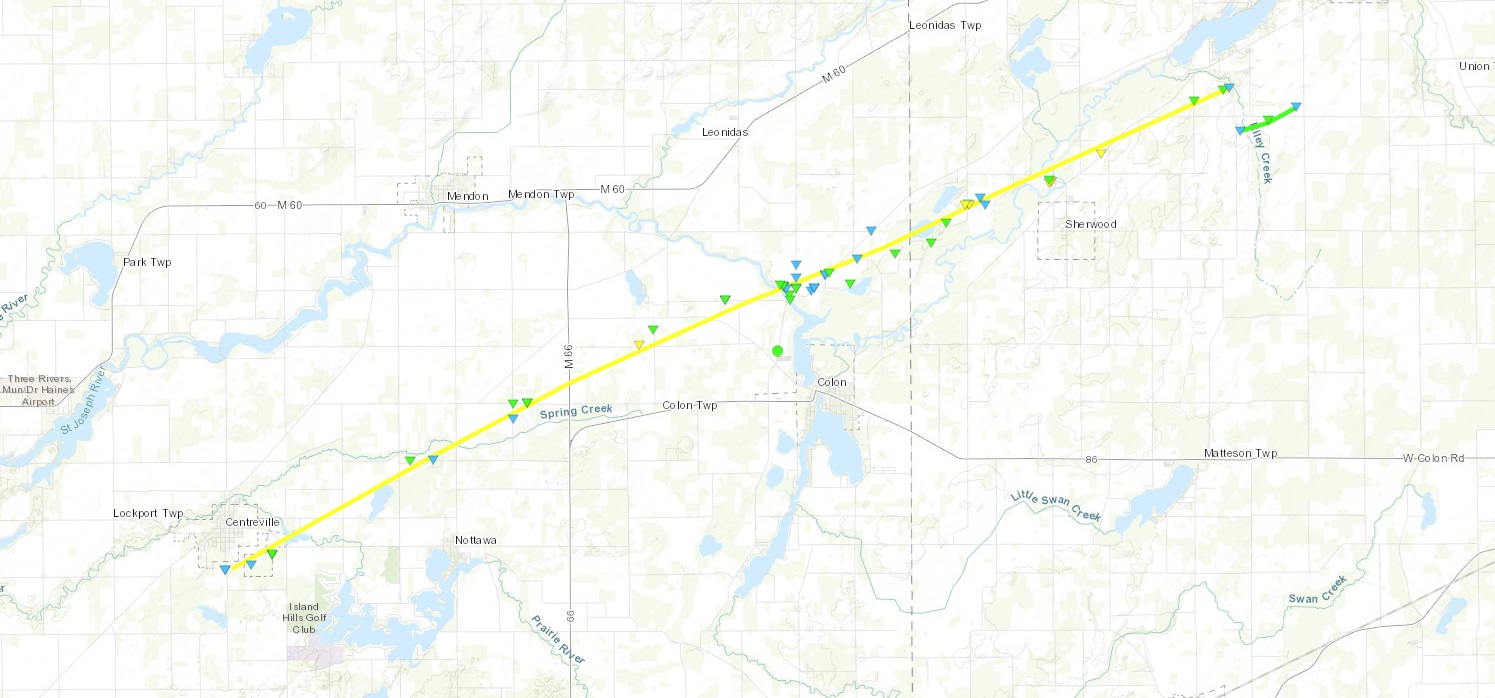 |
||||||||||||||||||||||||
|
||||||||||||||||||||||||
|
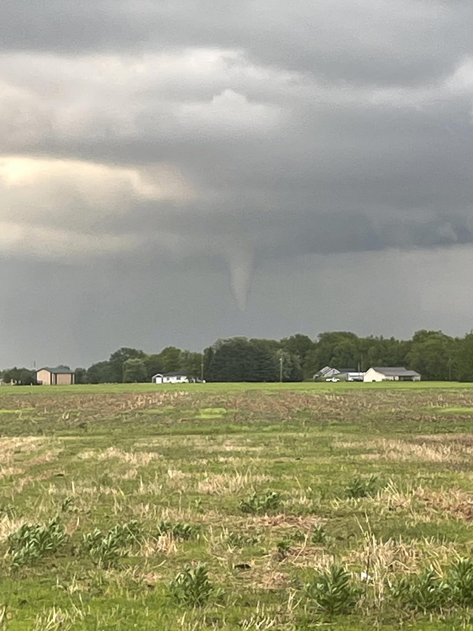
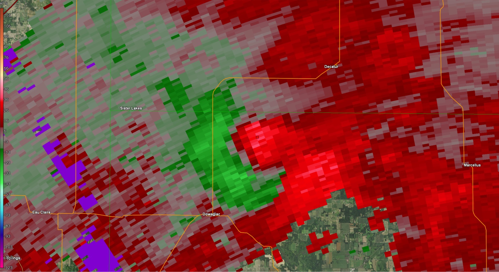
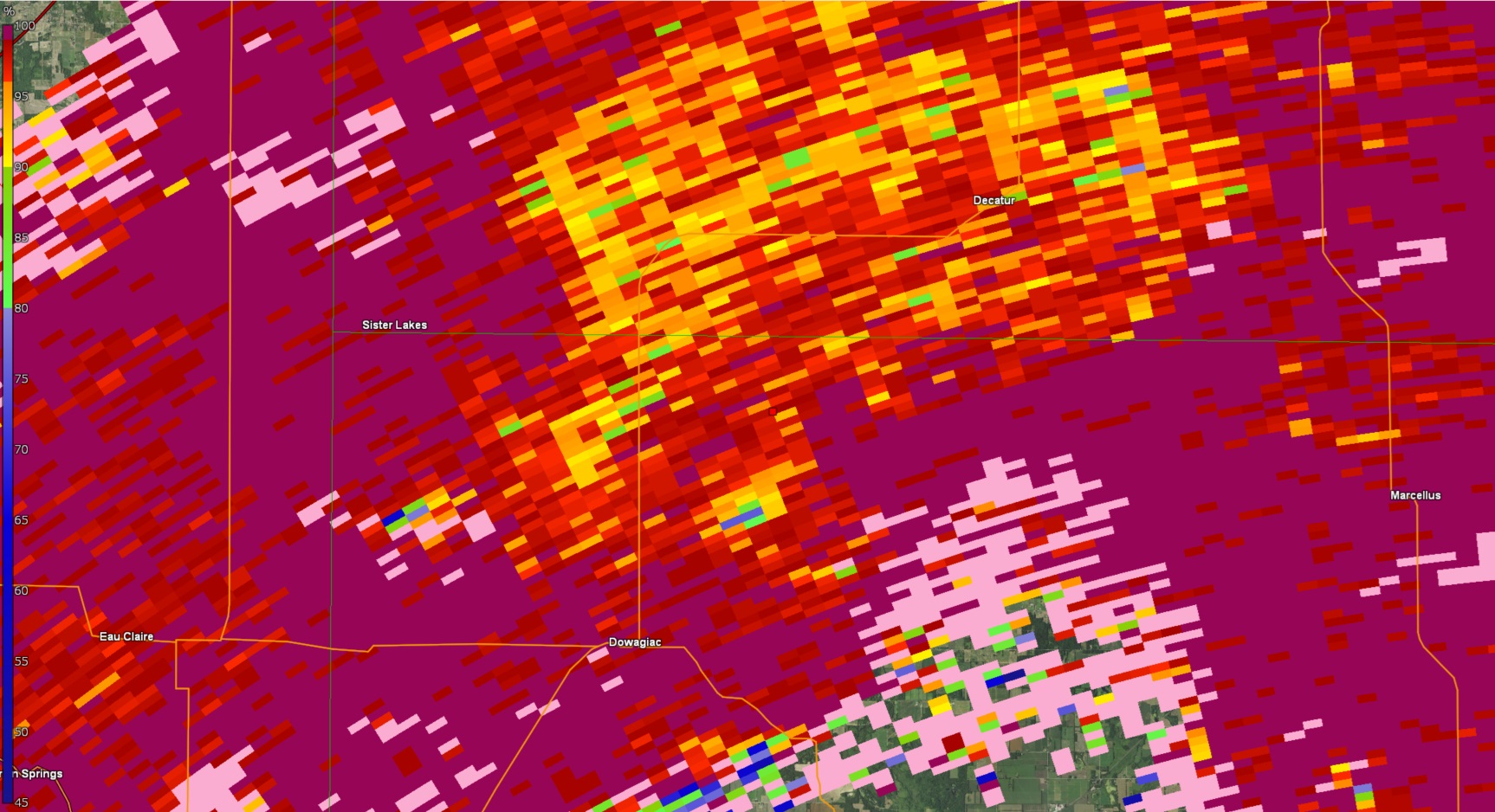
Tornado - Dowagiac/Twin Lakes
Track Map 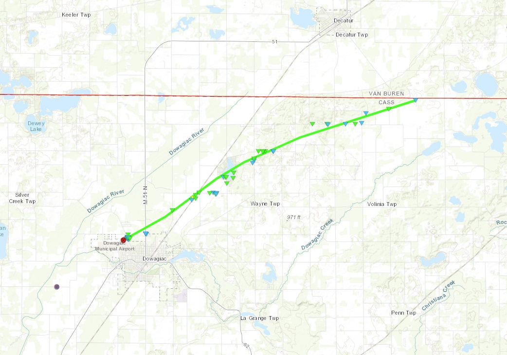 |
||||||||||||||||
|
||||||||||||||||
|
Tornado - Melrose, OH
Track Map 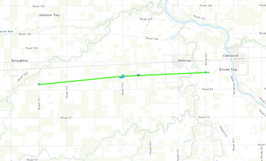 |
||||||||||||||||
|
||||||||||||||||
|
Tornado - 3 SW Arthur, OH
Track Map 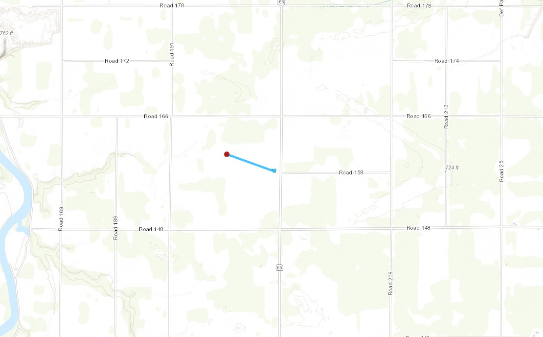 |
||||||||||||||||
|
Tornado - 2 S Belmore, OH
Track Map 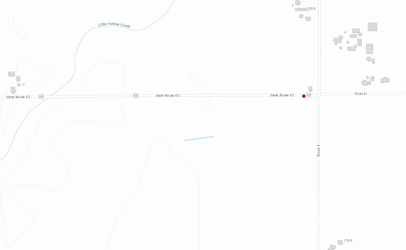 |
||||||||||||||||
The Enhanced Fujita (EF) Scale classifies tornadoes into the following categories:
| EF0 Weak 65-85 mph |
EF1 Moderate 86-110 mph |
EF2 Significant 111-135 mph |
EF3 Severe 136-165 mph |
EF4 Extreme 166-200 mph |
EF5 Catastrophic 200+ mph |
 |
|||||
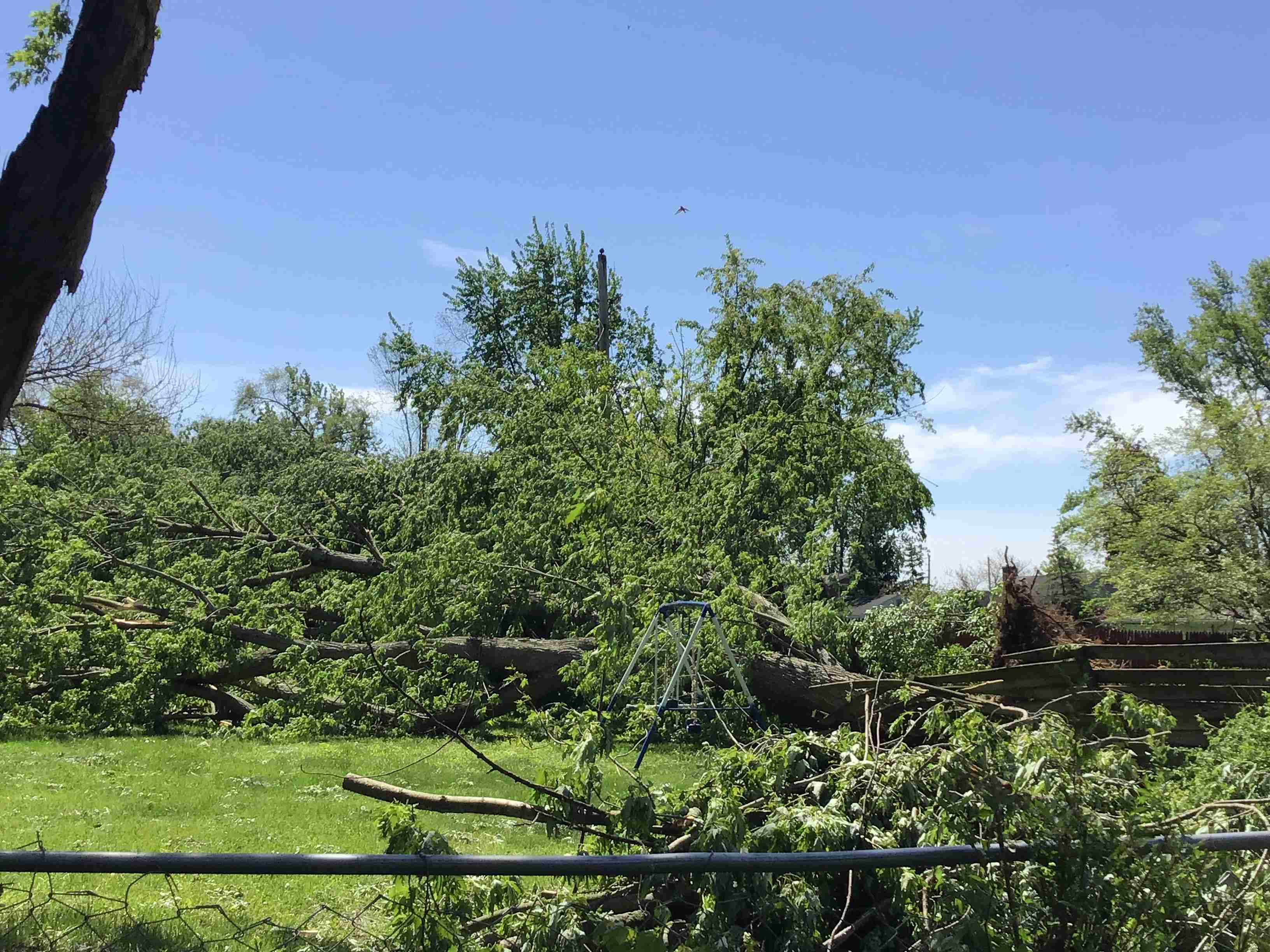
Wind & Hail:
More extensive wind damage occurred north of Peru, IN (Miami County), as well as from North Manchester (Wabash County) to South Whitley and Larwill (Whitley County). Summaries of the damage follow as well as overall location reports of the wind damage (non-tornadic) and then hail (up to 4"!!!!). Check out the original statements by clicking on the hyperlink of the product.
PERU IN WIND DAMAGE

A SEVERE THUNDERSTORM PRODUCED DAMAGE TO SEVERAL TREES BEGINNING
IN THE AREA OF W LOVERS LANE RD AND MERIDIAN RD, JUST NORTH OF
PERU AND THEN PROGRESSING NORTH NORTHEAST ALONG N WARSAW TRAIL
BEFORE ENDING IN THE AREA OF CR 490 N AND SR 19. THE DAMAGE WAS
CONSISTENT WITH STRAIGHT LINES WINDS RANGING FROM 65 TO 75 MPH.

NORTH MANCHESTER, SOUTH WHITLEY, AND LARWILL IN WIND DAMAGE

THE SAME STORM THAT PROUCED DAMAGE NORTH OF PERU, FURTHER
INTENSIFIED, CAUSING EPISODIC WIND DAMAGE IN A 12.4 MILE AREA
FROM NORTH MANCHESTER, TO SOUTH WHITLEY, TO THE SOUTH SIDE OF
LARWILL. BARNS WERE DESTROYED, METAL ROOF PANELS WERE LOFTED, A
DIESEL FUEL TANK WAS SPLIT OPEN, AND POWER LINES, POLES AND TREES
WERE DOWNED AS WELL. THE GREATEST DAMAGE OCCURRED AT THE
INTERSECTION OF W 1050 N AND STATE ROAD 13 JUST SOUTHWEST OF NORTH
MANCHESTER WHERE SEVERAL LARGE TREES FELL WEST OF THE INTERSECTION
AND THE ROOF OF A 2 STORY HOME WAS LIFTED AND THROWN INTO A NEARBY
FIELD. WHILE THERE WAS SOME INDICATIONS A WEAK CIRCULATION MIGHT
HAVE IMPACTED THE HOME, EVIDENCE WAS NOT ENOUGH TO RULE A TORNADO
WAS RESPONSIBLE. RADAR DATA INDICATED THIS THUNDERSTORM COLLAPSED
WITHIN THE AFORMENTIONED AREAS. DAMAGE REPORTED FROM BOTH THE
FORT WAYNE MEDIA MARKET AND EMERGENCY MANAGERS IS CONSISTENT WITH
75 TO 85 MPH WIND, WITH LOCALLY UP TO 90 MPH WINDS AT THE ABOVE
NOTED INTERSECTION.
Wind
Preliminary Local Storm Report...Summary
National Weather Service Northern Indiana
637 PM EDT Thu May 9 2024

..TIME...   ...EVENT...      ...CITY LOCATION...     ...LAT.LON...
..DATE...   ....MAG....      ..COUNTY LOCATION..ST.. ...SOURCE....
            ..REMARKS..

0330 PM     Tstm Wnd Dmg     3 WSW Michigan City     41.70N 86.93W
05/07/2024                   La Porte           IN   NWS Storm Survey

            Corrects previous tornado report from 3 WSW
            Michigan City. A storm survey of the area
            near Town of Pines found vehicle and tree
            damage consistent with a microburst as well
            as from large hail.

0612 PM     Tstm Wnd Dmg     2 E Laketon             40.98N 85.79W
05/07/2024                   Wabash             IN   Amateur Radio

            Report of 3 damaged residences, roof off one
            of them, as well uprooted trees and power
            lines down. On state route 13 between 1000
            and 1100 north.

0615 PM     Tstm Wnd Dmg     North Manchester        41.01N 85.77W
05/07/2024                   Wabash             IN   Public

            Large tree branches snapped in North
            Manchester (estimated 6-12 inches in
            diameter).

0615 PM     Tstm Wnd Dmg     North Manchester        41.01N 85.78W
05/07/2024                   Wabash             IN   Public

            Video on Facebook shows powerlines snapped
            on State Road 13. Also a report half a mile
            down the road of a barn destroyed.

0622 PM     Tstm Wnd Dmg     Fairmount               40.42N 85.65W
05/07/2024                   Grant              IN   Trained Spotter

            Powerlines down. Some roads are being
            blocked off.

0625 PM     Tstm Wnd Dmg     1 SW Logansport         40.74N 86.37W
05/07/2024                   Cass               IN   Emergency Mngr

            Large tree limbs down. Time estimated by
            radar.

0626 PM     Tstm Wnd Dmg     2 E Goblesville         41.00N 85.47W
05/07/2024                   Huntington         IN   Public

            Minor limb damage.

0627 PM     Tstm Wnd Dmg     South Whitley           41.09N 85.63W
05/07/2024                   Whitley            IN   Public

            Barn downed in South Whitley. Unknown how
            strong wind speeds were. Time estimated by
            radar.

0627 PM     Tstm Wnd Dmg     South Whitley           41.09N 85.63W
05/07/2024                   Whitley            IN   Public

            Time estimated by radar. Barn downed in
            South Whitley.

0634 PM     Tstm Wnd Dmg     1 W Columbia City       41.16N 85.50W
05/07/2024                   Whitley            IN   Public

            Time estimated by radar. Large tree snapped
            in Columbia City, Estimated 12 to 18 inches
            in diameter.

0635 PM     Tstm Wnd Dmg     Columbia City           41.16N 85.48W
05/07/2024                   Whitley            IN   Public

            Time estimated by radar. Photo on Facebook
            of a large tree snapped at the base in
            Columbia City. Estimated to be 1 to 2 feet
            in diameter.

0635 PM     Tstm Wnd Dmg     Larwill                 41.18N 85.62W
05/07/2024                   Whitley            IN   Public

            Photos on Facebook shows several barns
            damaged in Larwill. Time estimated from
            radar.

0652 PM     Tstm Wnd Dmg     3 N Green Center        41.35N 85.36W
05/07/2024                   Noble              IN   NWS Employee

            Delayed report and time estimated by radar.
            Several healthy tree branches around 12in in
            diameter broken and a couple more uprooted
            just west of N 350 E. Also hail damage to
            house siding with numerous pock marks/dents.

0655 PM     Tstm Wnd Dmg     Albion                  41.40N 85.42W
05/07/2024                   Noble              IN   Broadcast Media

            Time estimated by radar. Large tree,
            estimated 1 to 2 feet in diameter, uprooted
            in Albion.


&&
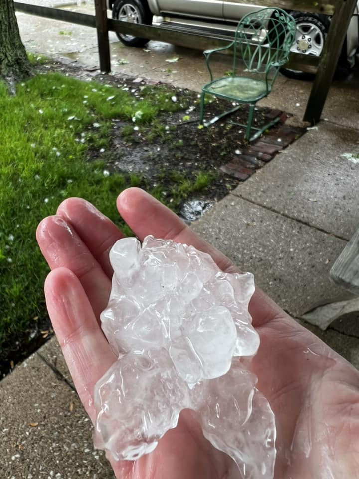
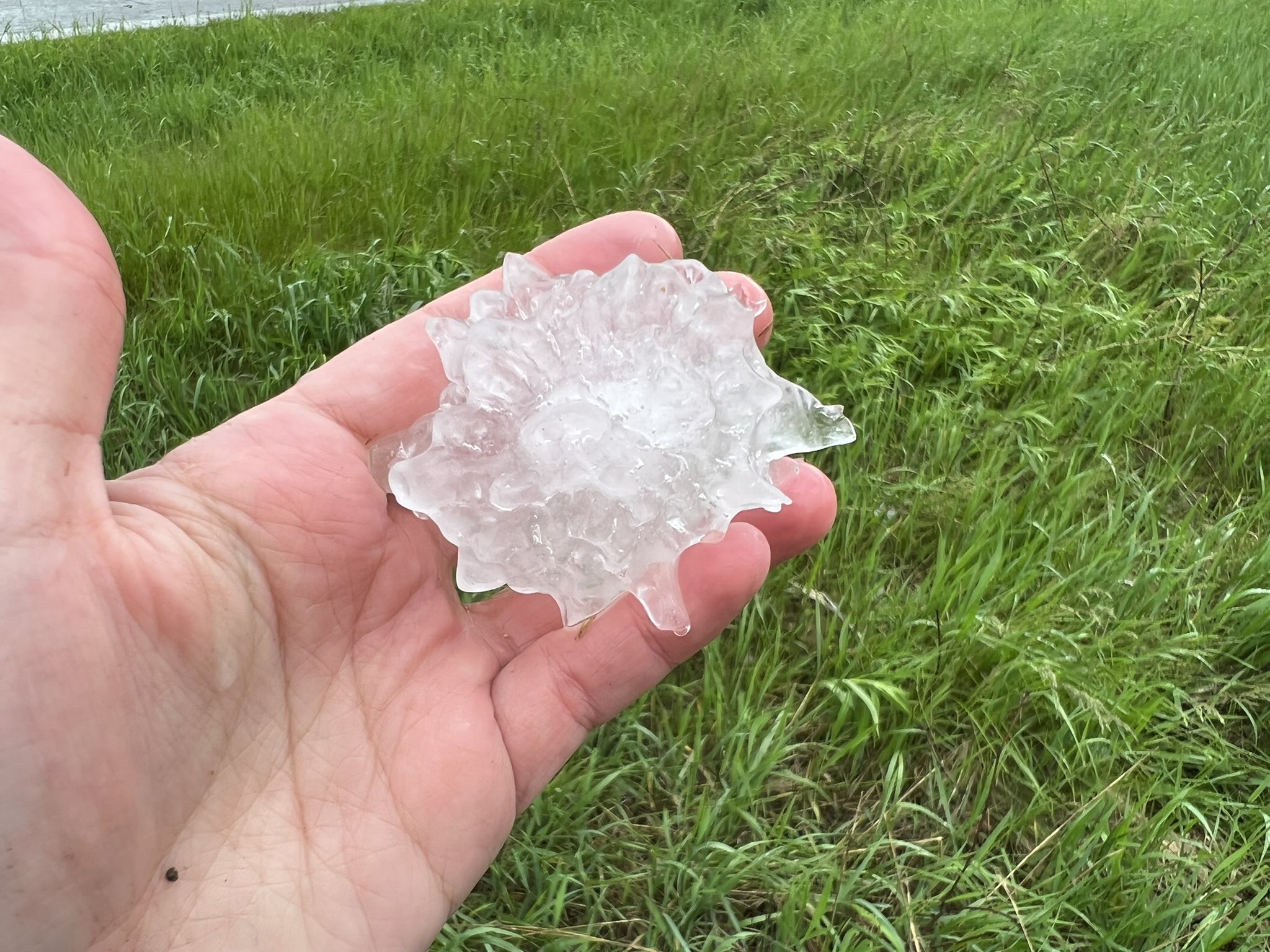
Hail
Public Information Statement
National Weather Service Northern Indiana
1221 PM EDT Wed May 8 2024

...HAIL REPORTS FROM MAY 7TH 2024...

Location                     Size      Time/Date       Lat/Lon

...Indiana...

...Allen County...
1 N Fort Wayne               0.88 in   0650 PM 05/07   41.09N/85.14W

...De Kalb County...
Ashley                       3.50 in   0722 PM 05/07   41.53N/85.07W
Corunna                      3.00 in   0705 PM 05/07   41.44N/85.14W
Ashley                       3.00 in   0718 PM 05/07   41.53N/85.07W
Corunna                      1.75 in   0657 PM 05/07   41.44N/85.14W

...Grant County...
1 SSE Jonesboro              1.00 in   0622 PM 05/07   40.46N/85.62W

...La Porte County...
Michigan City                3.50 in   0415 PM 05/07   41.72N/86.88W
Michigan City                3.00 in   0500 PM 05/07   41.71N/86.88W
Michigan City                2.50 in   0423 PM 05/07   41.72N/86.88W
1 SSW Long Beach             2.50 in   0426 PM 05/07   41.74N/86.86W
1 S Michigan City            2.00 in   0420 PM 05/07   41.70N/86.88W
1 S Michigan City            2.00 in   0420 PM 05/07   41.70N/86.88W
1 NW Michigan City           1.75 in   0422 PM 05/07   41.72N/86.89W
1 WSW Michiana Shores        1.00 in   0428 PM 05/07   41.75N/86.83W

...Noble County...
Kendallville                 3.50 in   0725 PM 05/07   41.45N/85.26W
Kendallville                 3.00 in   0650 PM 05/07   41.44N/85.27W
Kendallville                 3.00 in   0655 PM 05/07   41.44N/85.26W
Kendallville                 3.00 in   0705 PM 05/07   41.45N/85.26W
2 W Lisbon                   1.75 in   0654 PM 05/07   41.41N/85.29W
Avilla                       1.00 in   0653 PM 05/07   41.36N/85.24W

...Steuben County...
Hudson                       3.00 in   0709 PM 05/07   41.53N/85.08W
1 NE Hudson                  2.50 in   0709 PM 05/07   41.54N/85.07W
Pleasant Lake                1.75 in   0712 PM 05/07   41.58N/85.02W
1 S Angola                   1.75 in   0715 PM 05/07   41.63N/85.00W
1 N Hudson                   1.00 in   0700 PM 05/07   41.54N/85.08W

...Wabash County...
1 S North Manchester         1.00 in   0627 PM 05/07   40.99N/85.77W

...Michigan...

...Berrien County...
New Buffalo                  1.00 in   0438 PM 05/07   41.79N/86.74W
Berrien Springs              1.00 in   0500 PM 05/07   41.95N/86.34W

...Branch County...
Union City                   4.00 in   0611 PM 05/07   42.07N/85.14W
Coldwater                    1.50 in   0617 PM 05/07   41.94N/85.00W

...Cass County...
1 N Dewey Lake               1.00 in   0550 PM 05/07   42.07N/86.19W

...Hillsdale County...
Hillsdale                    1.75 in   0743 PM 05/07   41.93N/84.64W

...St. Joseph County...
Leonidas                     4.00 in   0608 PM 05/07   42.02N/85.35W
Leonidas                     2.50 in   0600 PM 05/07   42.02N/85.35W
2 NNW Fairfax                1.75 in   0556 PM 05/07   41.98N/85.38W
Three Rivers                 1.50 in   0530 PM 05/07   41.94N/85.63W

Observations are collected from a variety of sources with varying
equipment and exposures. We thank all volunteer weather observers
for their dedication. Not all data listed are considered official.
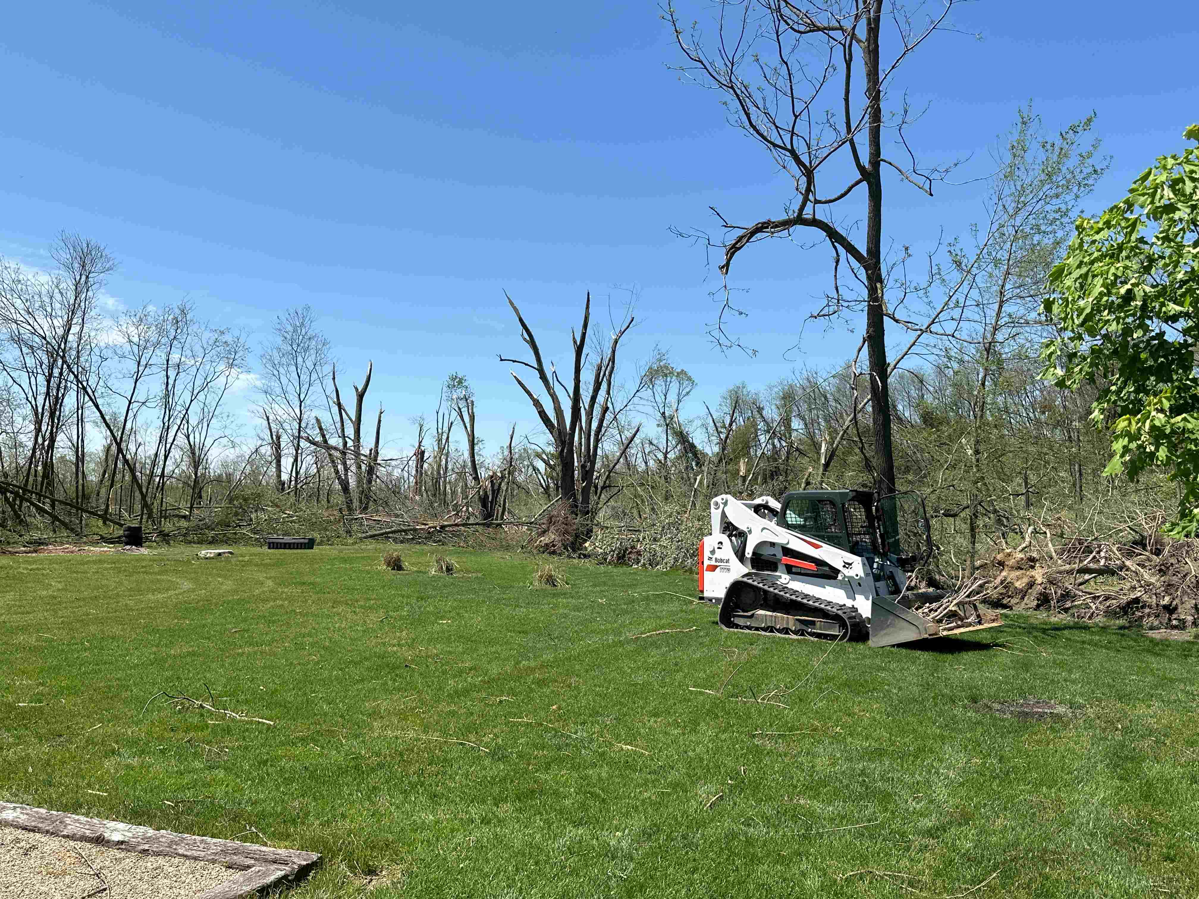
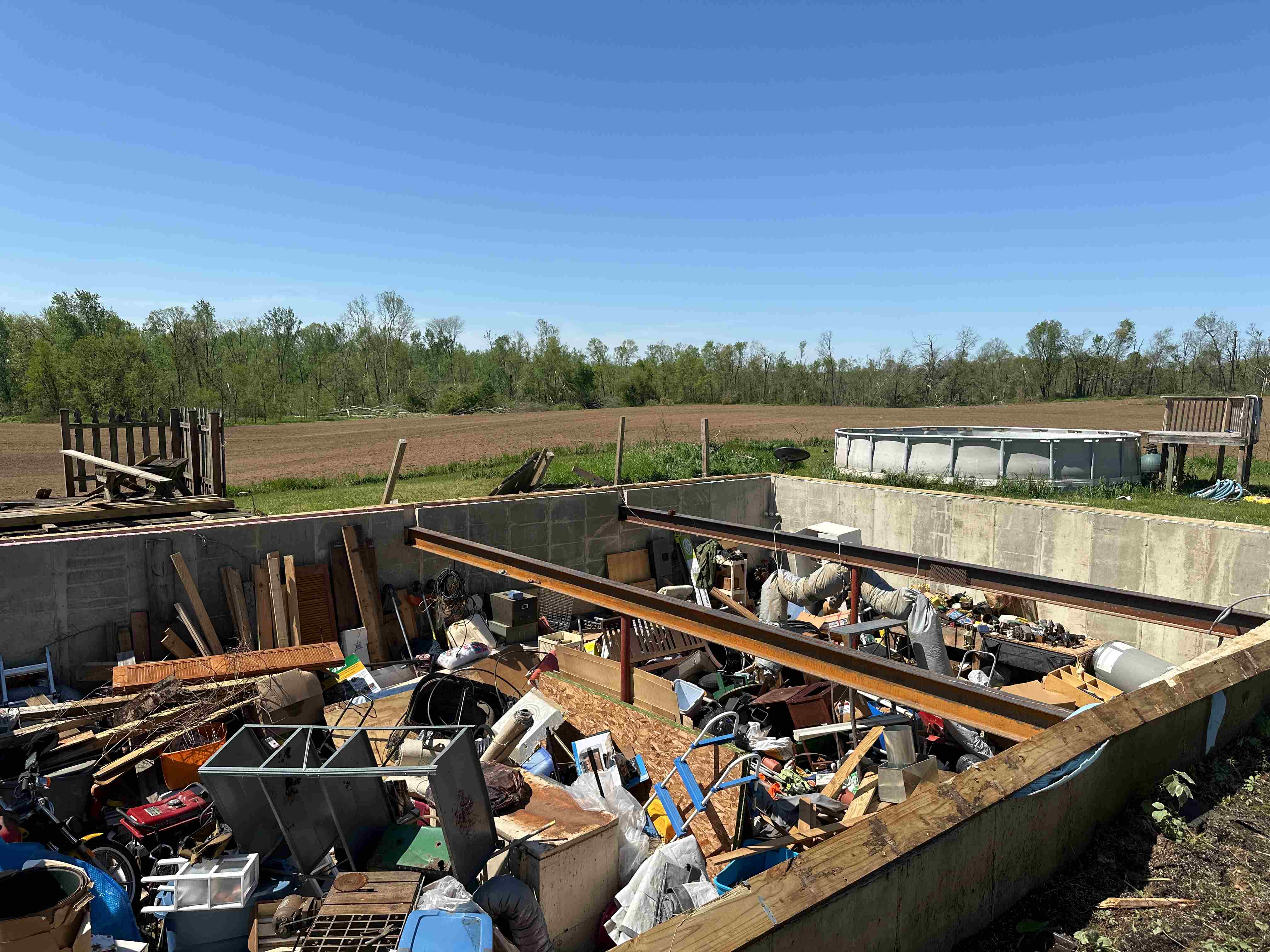
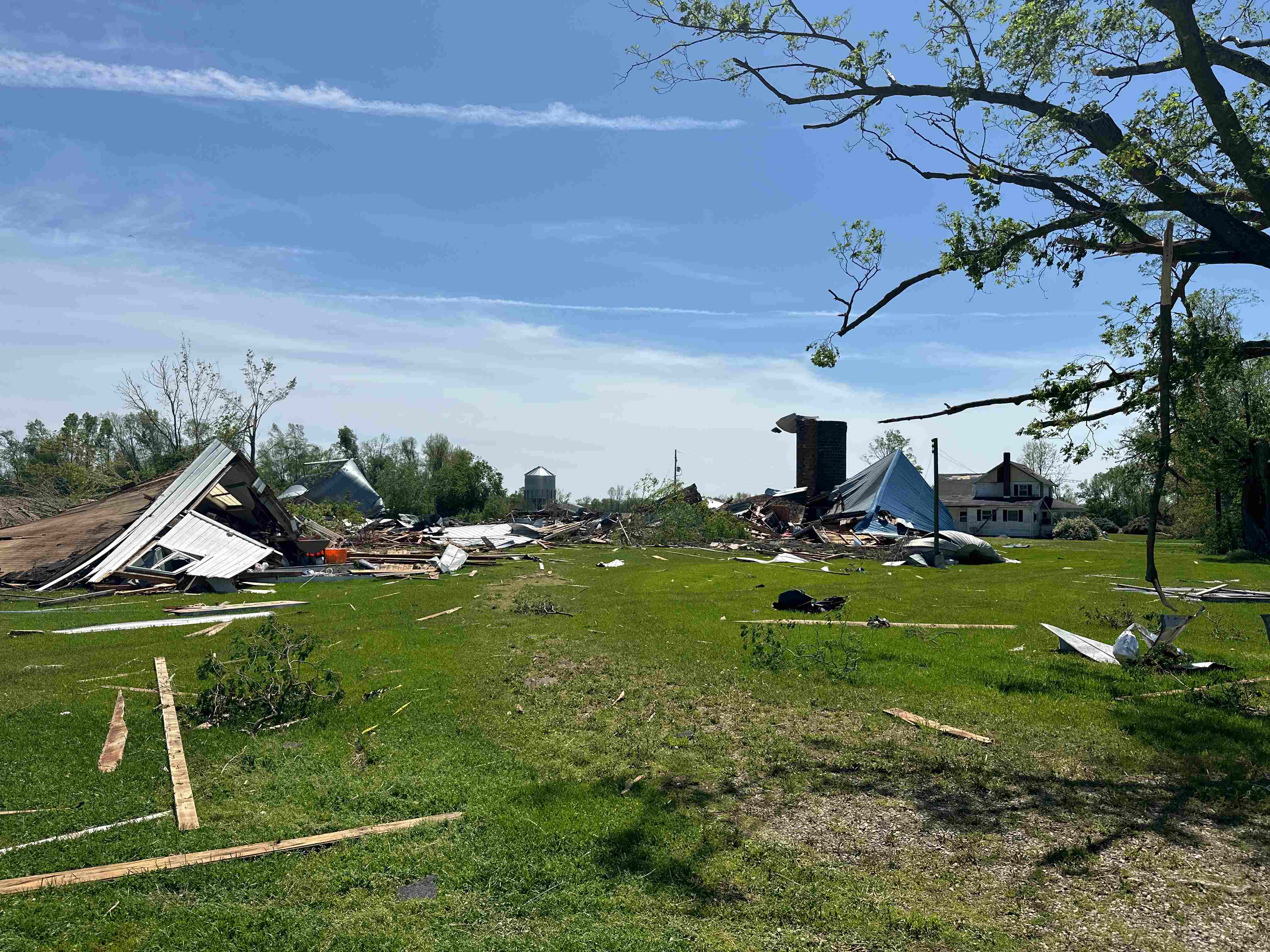
Photos & Video
 |
 |
 |
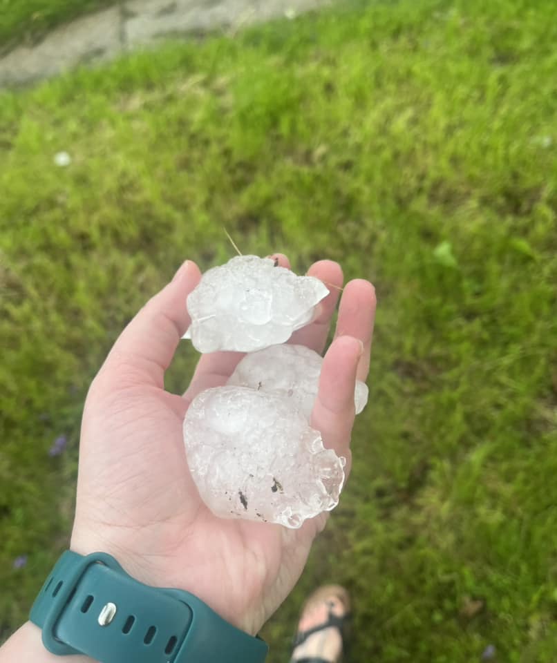 |
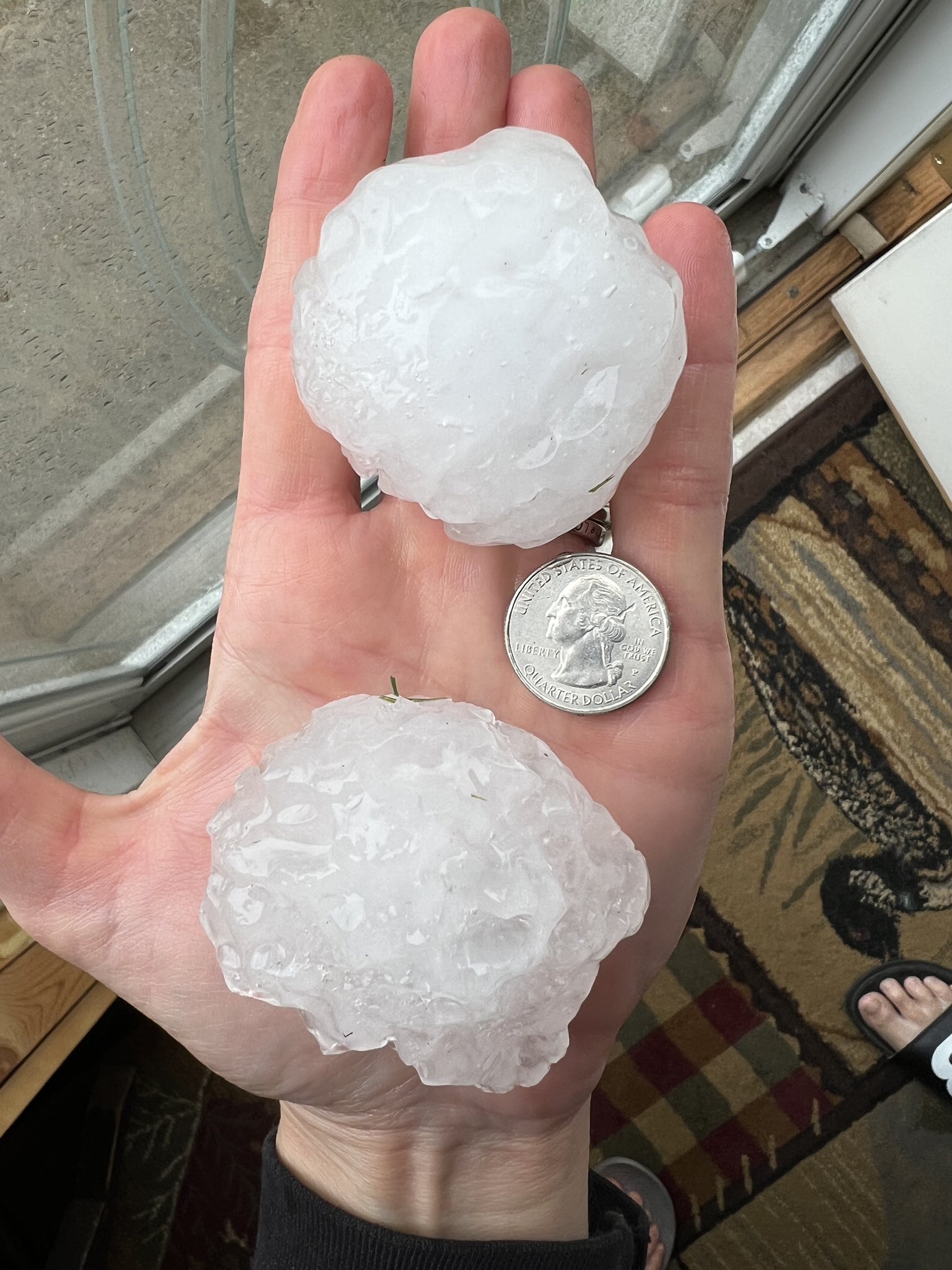
| Very large hail from Michigan City. (Pamela Bailey) | 3 inch diameter hail from near Leonidas, MI. (Katie NIckolaou) | Giant hail near Ashley, IN. (Susan Gudas) |
Very large hail near Kendallville. (Samantha Shaw) |
 |
 |
 |
 |
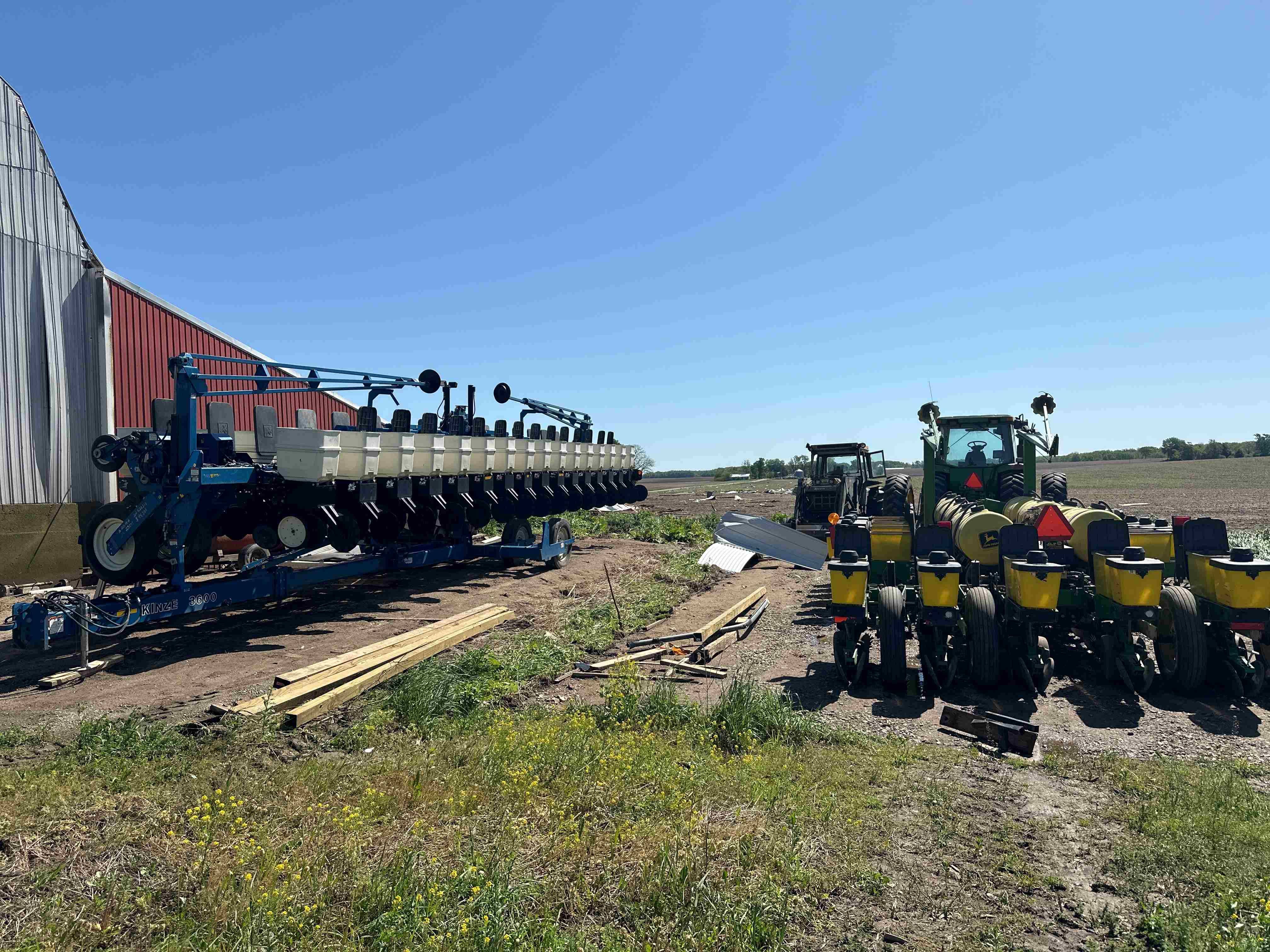
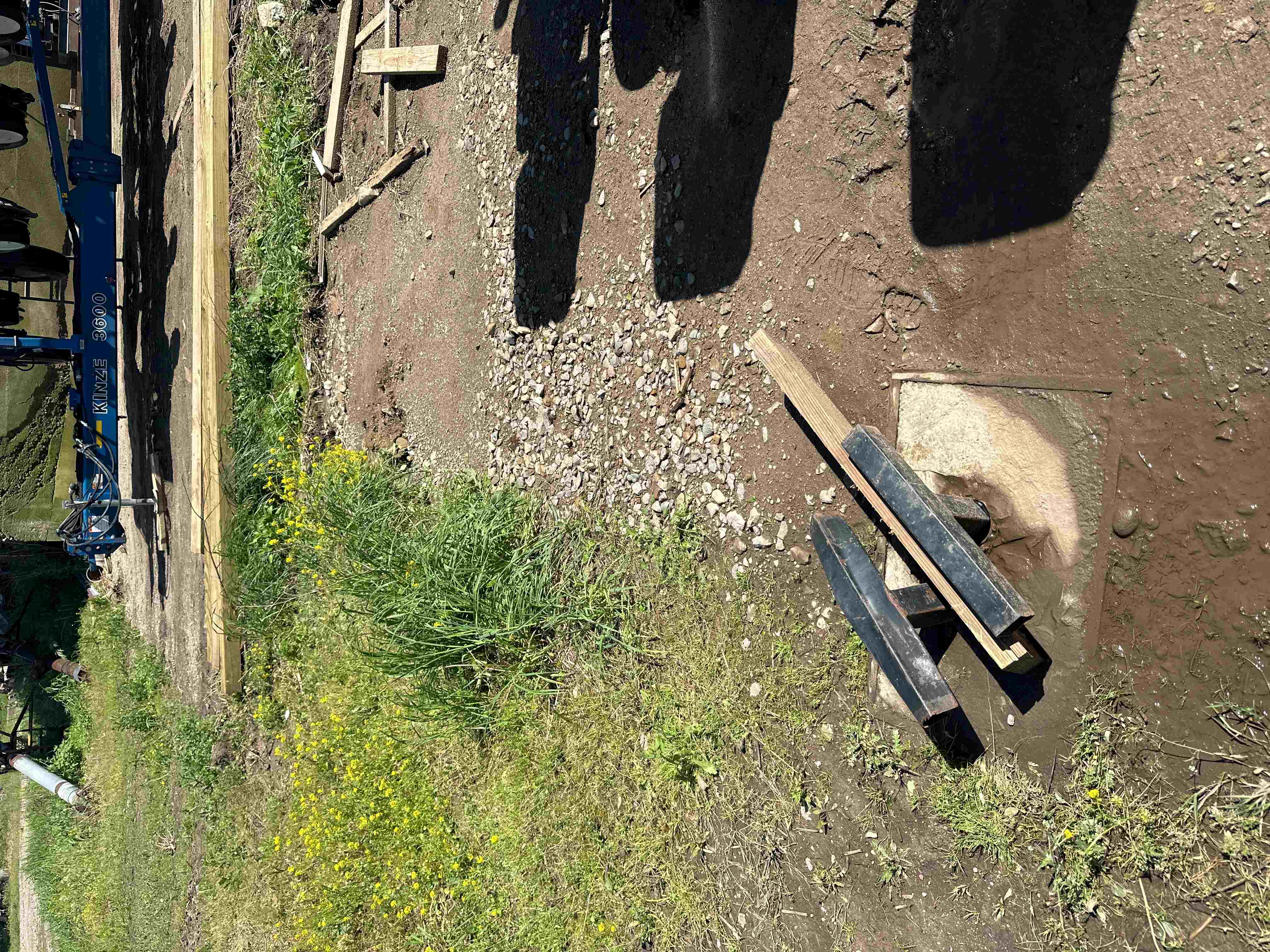
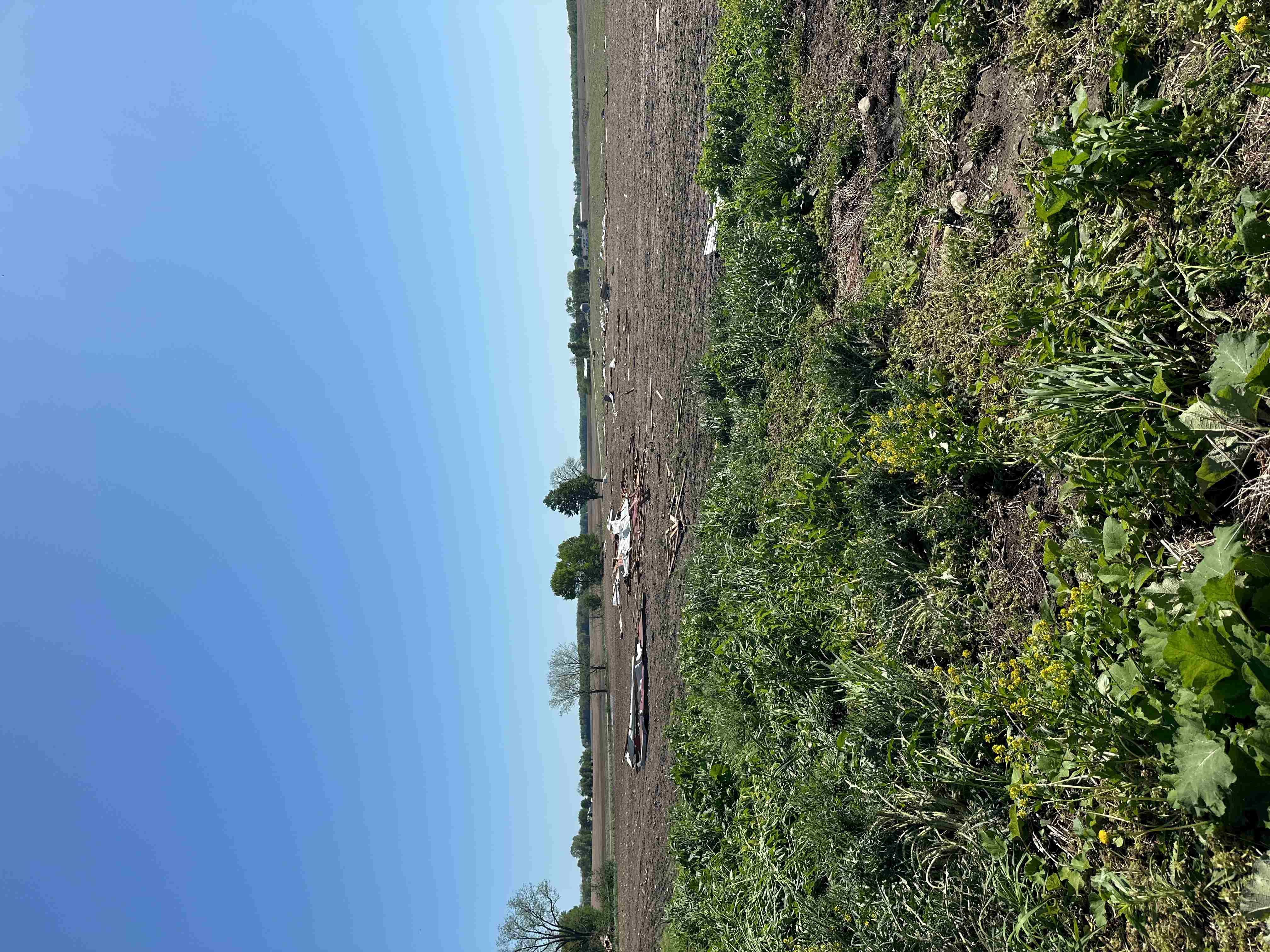
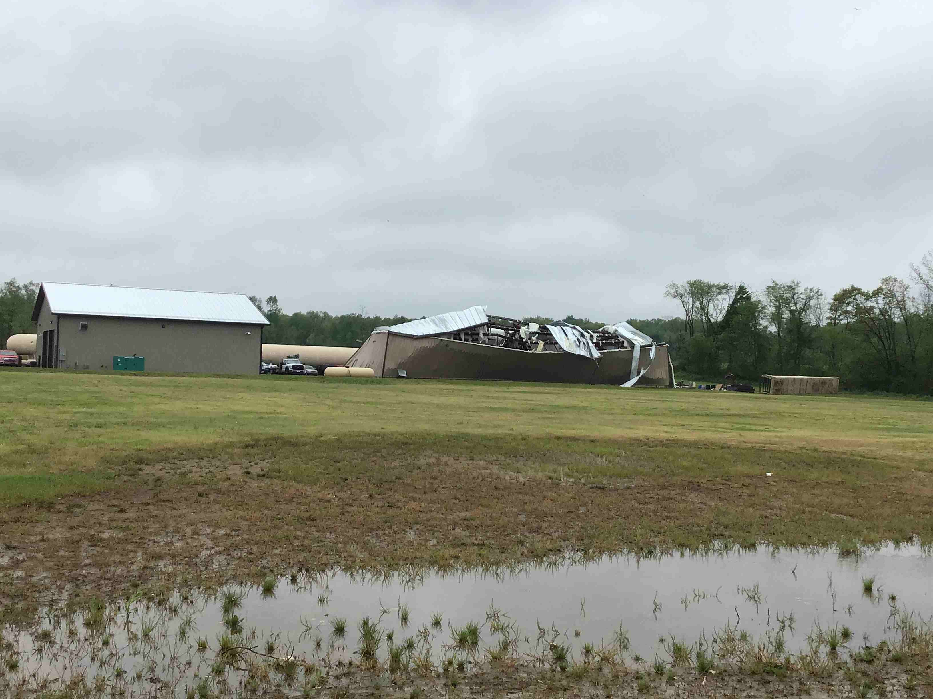
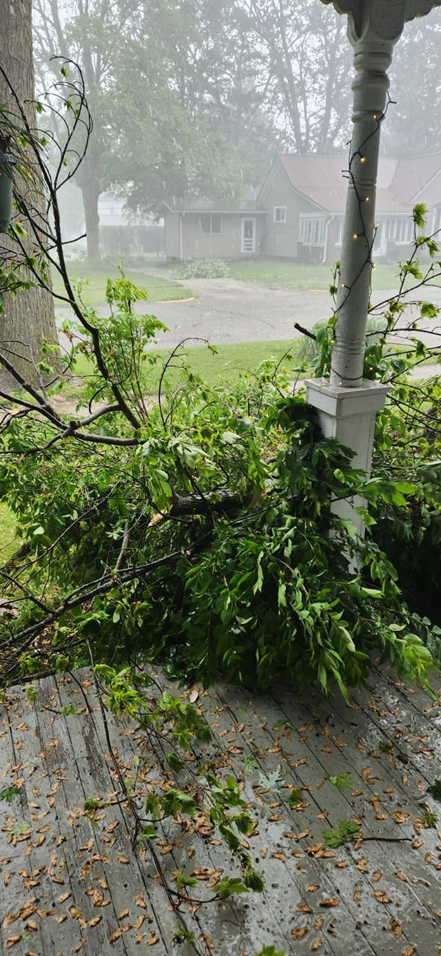
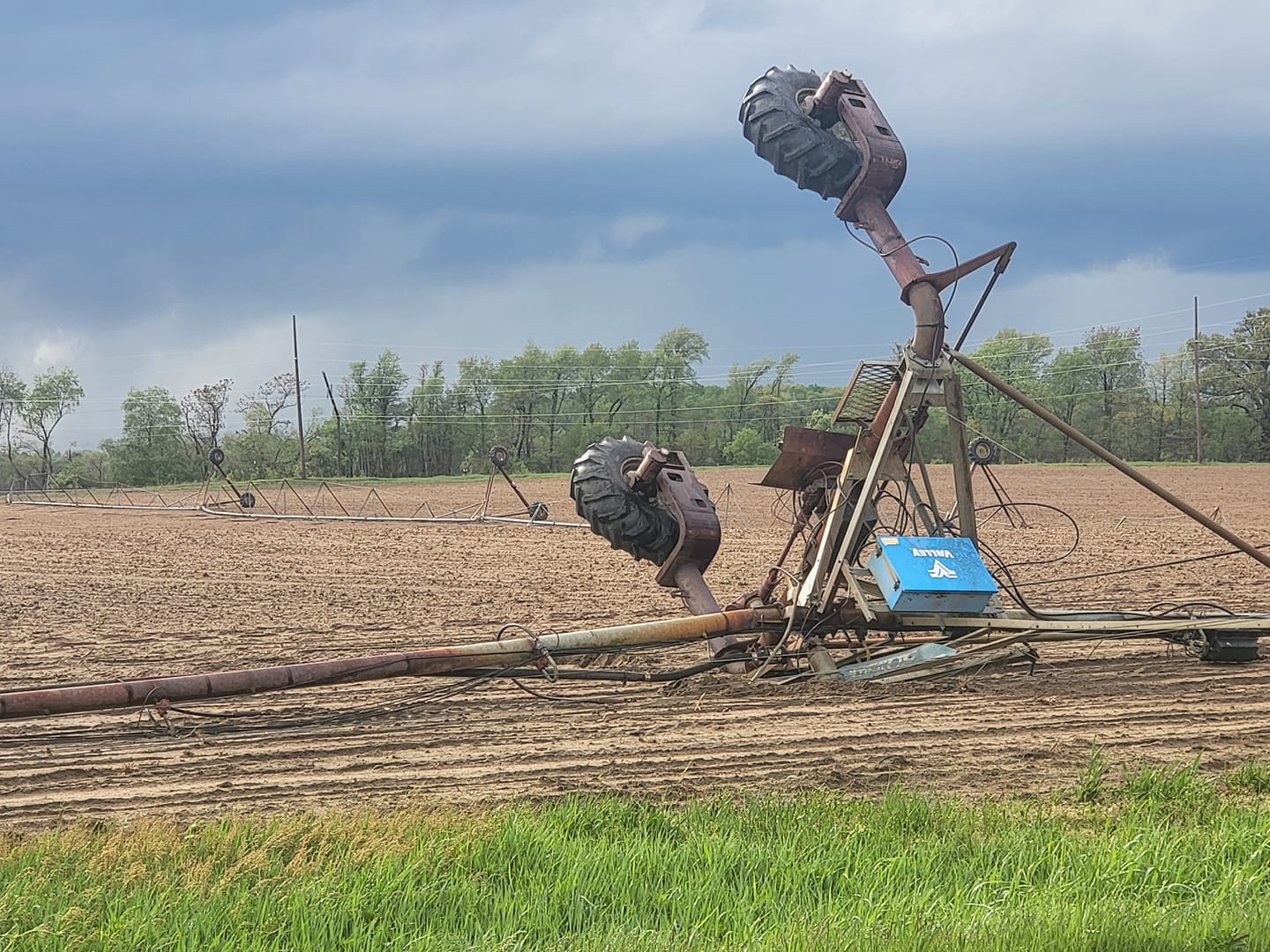
| Tree damage in North Manchester, IN. (Meghann Foust) | Damage to center-pivot near Dowagiac, MI. (Monica Clupper) | Damage to a structure in Whitley County, IN. (Rick Hicks) |
Funnel Cloud in southeast Paulding County. (Aaron Pogue) |
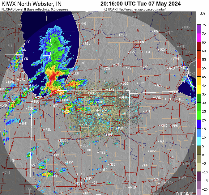
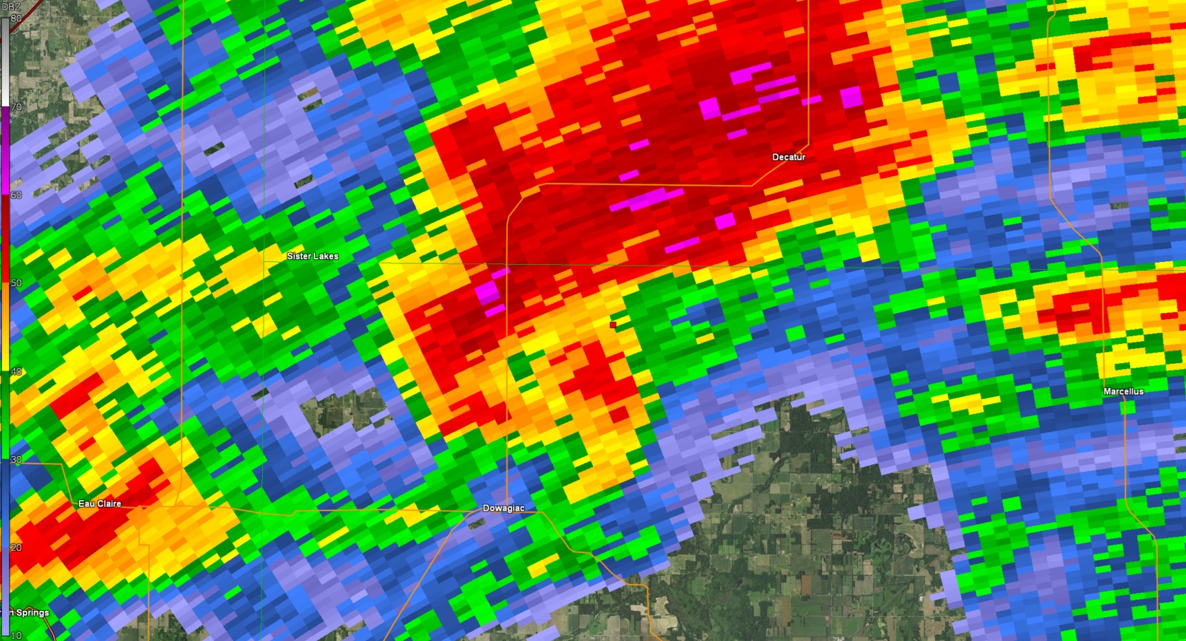
Radar
Here is a loop of radar data from the event. Storms began in the afternoon after a round of morning convection, and continued into the evening hours.
 |
 |
 |
 |
| KIWX 0.5 reflectivity from late afternoon May 7th to late evening May 7th. | KIWX 0.5 degree reflectivity for tornadic storm north of Dowagiac, MI. Valid at 5:19 PM EDT | KIWX 0.5 degree storm relative motion for tornadic storm north of Dowagiac, MI. Valid 5:19 PM EDT | KIWX 0.5 degree Correlation Coefficient (CC) for tornadic storm north of Dowagiac, MI. Note the drop in CC on southern flank of storm indicating debris aloft with the tornado. |
 |
 |
||
| KIWX 0.5 reflectivity from Sherwood, MI vicinity. Valid ~ 600 PM EDT | KIWX 0.5 degree storm relative motion from Sherwood, MI vicinity. Valid ~ 600 PM EDT. A tornado was ongoing at this time. |
Storm Reports
Preliminary Local Storm Report...Summary
National Weather Service Northern Indiana
637 PM EDT Thu May 9 2024
..TIME... ...EVENT... ...CITY LOCATION... ...LAT.LON...
..DATE... ....MAG.... ..COUNTY LOCATION..ST.. ...SOURCE....
..REMARKS..
0330 PM Tstm Wnd Dmg 3 WSW Michigan City 41.70N 86.93W
05/07/2024 La Porte IN NWS Storm Survey
Corrects previous tornado report from 3 WSW
Michigan City. A storm survey of the area
near Town of Pines found vehicle and tree
damage consistent with a microburst as well
as from large hail.
0415 PM Hail Michigan City 41.72N 86.88W
05/07/2024 E3.50 Inch La Porte IN Public
0420 PM Hail 1 S Michigan City 41.70N 86.88W
05/07/2024 M2.00 Inch La Porte IN Public
0420 PM Hail 1 S Michigan City 41.70N 86.88W
05/07/2024 M2.00 Inch La Porte IN Trained Spotter
0422 PM Hail 1 NW Michigan City 41.72N 86.89W
05/07/2024 M1.75 Inch La Porte IN Trained Spotter
0423 PM Hail Michigan City 41.72N 86.88W
05/07/2024 M2.50 Inch La Porte IN Trained Spotter
0426 PM Hail 1 S Long Beach 41.74N 86.86W
05/07/2024 M2.50 Inch La Porte IN Public
Reported by Trained Spotter.
0428 PM Hail 1 W Michiana Shores 41.75N 86.83W
05/07/2024 M1.00 Inch La Porte IN Trained Spotter
0438 PM Hail New Buffalo 41.79N 86.74W
05/07/2024 M1.00 Inch Berrien MI Trained Spotter
0500 PM Hail Berrien Springs 41.95N 86.34W
05/07/2024 M1.00 Inch Berrien MI Public
Delayed report.
0500 PM Hail Michigan City 41.71N 86.88W
05/07/2024 M3.00 Inch La Porte IN Public
Hail damage to vehicles in downtown Michigan
City. Public report of 2 to 2.5 inch
hailstones.
0511 PM Tornado 1 NW Dowagiac 42.00N 86.12W
05/07/2024 Cass MI NWS Storm Survey
An EF-1 tornado with maximum wind speeds of
95 mph occurred in the early evening of May
7th in Cass County, MI. The tornado touched
down in a field just north of the Dowagiac
Municipal Airport. The tornado did damage to
trees along Middle Crossing Rd, even
uprooting a few large trees onto homes in
the area. The tornado continued northeast,
where a power pole was snapped and a few
center pivots were flipped in a field
adjacent to the Amtrak railroad near the
intersection of Gage Street and Atwood Road.
The tornado reached its maximum width in the
Twin Lakes area, where extensive damage to
trees was noted on all sides of both lakes.
Hundreds of trees of varying sizes were
snapped and uprooted in Twin Lakes. The
tornado continued northeast, snapping trees
on Dewey Lake Street. Additional damage to a
barn was noted on Wickett Road. The tornado
dissipated near the Cass/Van Buren County
line.
0511 PM Flood Saint Joseph 42.10N 86.49W
05/07/2024 Berrien MI Public
Corrects previous flood report from Saint
Joseph. Delayed report of street flooding in
downtown Saint Joseph, MI on the 300 block
of Main Street.
0513 PM Lightning Dowagiac 41.98N 86.11W
05/07/2024 Cass MI Public
Time estimated by radar. Photo on Facebook
shows the Ramona Skating Rink in Dowagiac on
fire. Public reports states that the rink
was hit by lightning, caught fire, and and
burned down.
0515 PM Tornado 4 NE Dowagiac 42.03N 86.05W
05/07/2024 Cass MI Public
Photos on Facebook show heavy tree damage
near Twin Lakes, just northeast of Dowagiac.
Numerous trees of varying sizes snapped or
uprooted. Time estimated by radar.
0515 PM Tornado 3 NE Dowagiac 42.02N 86.07W
05/07/2024 Cass MI Public
Time estimated by radar. Facebook photo
shows two center pivots flipped and damaged.
At the intersection of Atwood Road and Gage
Street.
0516 PM Flood 2 W Elkhart 41.70N 86.00W
05/07/2024 Elkhart IN Public
Report from mPING: Street/road flooding;
Street/road closed.
0530 PM Hail Three Rivers 41.94N 85.63W
05/07/2024 E1.50 Inch St. Joseph MI Public
Delayed report. Time estimated by radar.
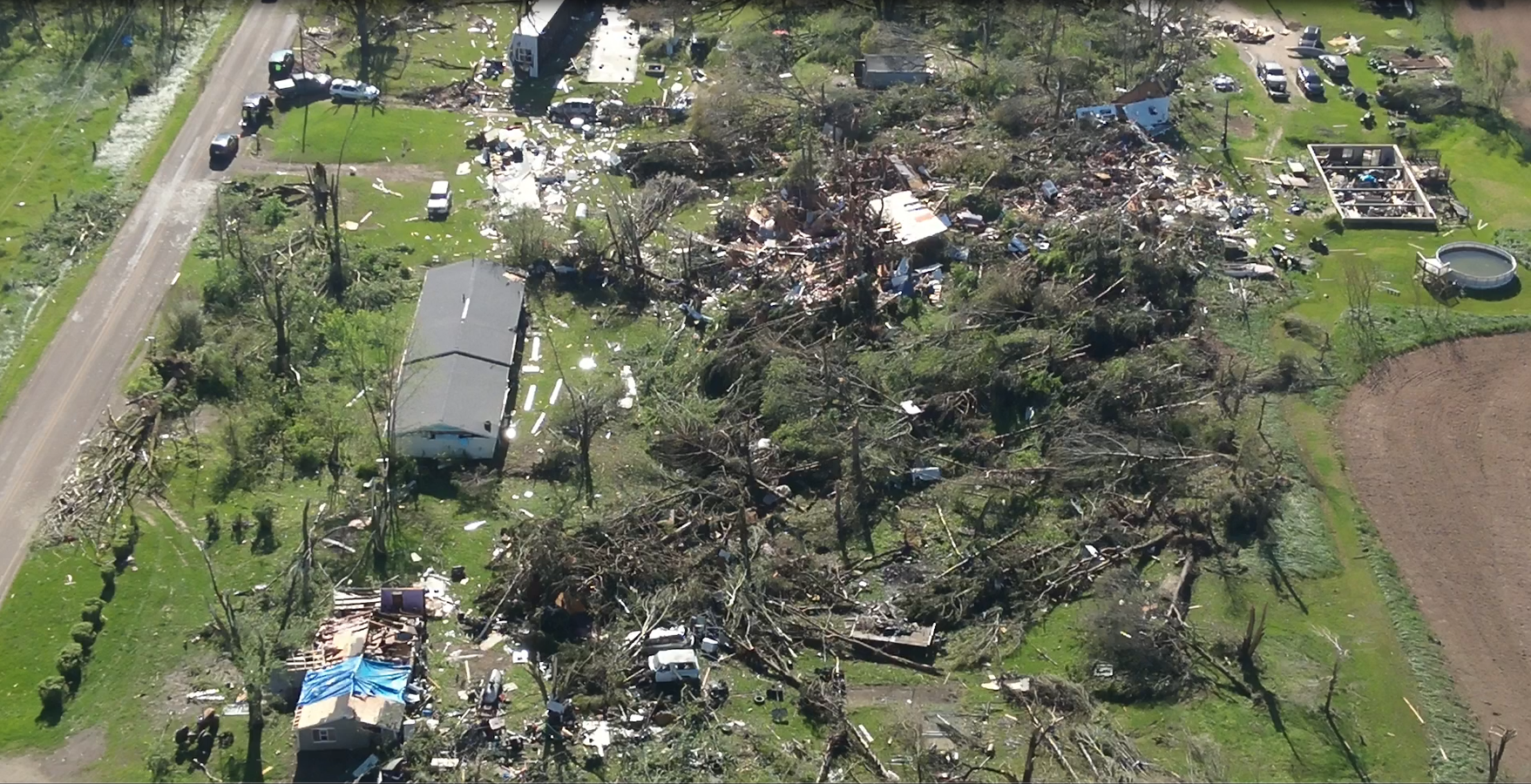
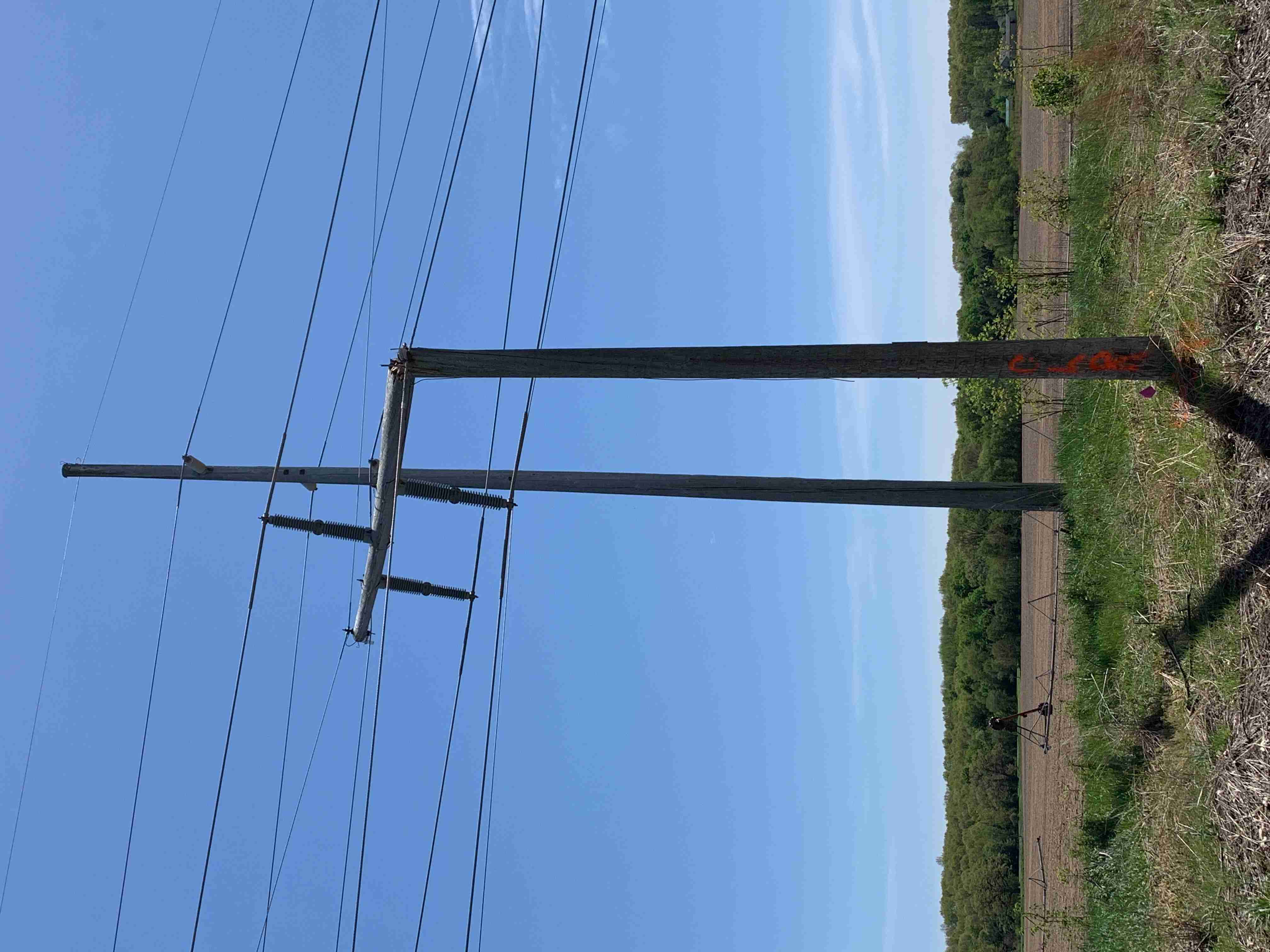
0541 PM Tornado 1 S Centreville 41.91N 85.53W
05/07/2024 St. Joseph MI NWS Storm Survey
A tornado touched down in St. Joseph county
on the south side of Centreville and then
tracked northeast, passing north of Colon,
crossing into Branch county near Havens and
Goodrich Lake. The tornado finally weakened
and lifted south of Union Lake. Extensive
damage occurred to trees and center pivot
irrigation systems along the track with the
most significant damage occurring from north
of Colon to north of Sherwood. Several homes
suffered loss of roof and walls, resulting
in the area of highest damage consistent
with EF2 and estimated winds of 130 mph.
Video footage and layout of some tree damage
confirms this was a multi vortex tornado
during its peak intensity. There was 1
injury reported near Colon, MI but that
person has since been treated at the
hospital and released.
0542 PM Tornado Centreville 41.92N 85.53W
05/07/2024 St. Joseph MI Public
Video on Facebook shows tornado on the
ground near Centreville MI. Time estimated
from radar.
0543 PM Tornado 1 ESE Wasepi 41.94N 85.45W
05/07/2024 St. Joseph MI Public
Photo on Facebook of a large tornado on the
ground between Centreville and Colon, just
north of Nottawa. Time estimated by radar.
0550 PM Tornado 3 ESE Mendon 41.99N 85.41W
05/07/2024 St. Joseph MI Trained Spotter
0550 PM Tornado Colon 41.96N 85.32W
05/07/2024 St. Joseph MI Trained Spotter
Corrects time of previous tornado report
from Colon. Trained spotter recorded video
of a large cone tornado in Colon.
0550 PM Tornado Colon 41.96N 85.32W
05/07/2024 St. Joseph MI Trained Spotter
Damage to a home and trees snapped in Colon.
Time estimated by TDS on radar.
0550 PM Hail 1 N Dewey Lake 42.07N 86.19W
05/07/2024 E1.00 Inch Cass MI Public
Report from mPING: Quarter (1.00 in.).
0552 PM Tornado Colon 41.96N 85.32W
05/07/2024 St. Joseph MI Trained Spotter
Trees snapped near Colon, likely from a
tornado. Photos sent in by a trained
spotter. Confirmed TDS on radar. Time
estimated by radar.
0553 PM Tornado 1 WNW Colon 41.97N 85.34W
05/07/2024 St. Joseph MI Amateur Radio
Corrects previous tstm wnd dmg report from 1
WNW Colon. Reports of trees down and farm
damage on Farrand Rd, west of the
roundabout.
0556 PM Hail 2 NNW Fairfax 41.98N 85.38W
05/07/2024 M1.75 Inch St. Joseph MI Trained Spotter
0600 PM Tornado Mendon 42.01N 85.45W
05/07/2024 St. Joseph MI Broadcast Media
Photo of a tornado in Mendon and time of
occurrence relayed by broadcast media.
Several photos from X/Twitter show a large
tornado on the ground in and near Mendon MI.
0600 PM Tornado Leonidas 42.02N 85.35W
05/07/2024 St. Joseph MI Broadcast Media
Tree damage reported in Leonidas by
broadcast media.
0600 PM Tornado Leonidas 42.03N 85.35W
05/07/2024 St. Joseph MI Trained Spotter
Tree damage near Glenwood.
0600 PM Tornado Sherwood 42.00N 85.24W
05/07/2024 Branch MI Trained Spotter
Tornado damage in Sherwood along Arney Road
relayed by trained spotters. Trees snapped
and damage to at least one house. Time
estimated from radar.
0600 PM Tornado Sherwood 42.00N 85.24W
05/07/2024 Branch MI Trained Spotter
Video of debris being lofted in Sherwood.
Time estimated by TDS on radar. Relayed by
trained spotter.
0600 PM Hail Leonidas 42.02N 85.35W
05/07/2024 M2.50 Inch St. Joseph MI Broadcast Media
Pictures shared of up to tennis ball size
hail.
0607 PM Tornado 3 SW Union City 42.03N 85.18W
05/07/2024 Branch MI NWS Storm Survey
A brief EF-1 tornado developed southwest of
Union City, MI as larger tornado dissipated
to the northwest (rating on the larger
tornado TBD). This tornado moved along W
Girard Road between Babcock Rd and Arbogast
Rd, destroying a machine shed and ripping
out some of the anchor posts.
0608 PM Hail Leonidas 42.02N 85.35W
05/07/2024 M4.00 Inch St. Joseph MI Broadcast Media
Photo on X/Twitter shows a 4 inch diameter
hailstone!.
0611 PM Tornado 2 N Silver Lake 41.66N 85.07W
05/07/2024 Steuben IN NWS Storm Survey
We can confirm a brief EF-U tornado touched
down in a field north of W 100 N and west of
W Landis Road at 6:11 PM EDT on Tuesday, May
7th. The tornado dissipated over the field
and did not cause any known damage.
0611 PM Tornado 2 N Silver Lake 41.66N 85.07W
05/07/2024 Steuben IN NWS Storm Survey
Numerous reports of a funnel cloud were
received from west of Angola to north of
Angola including in the area of Crooked and
Loon lakes. Video footage confirms a brief
touchdown north of W 100 N and west of W
Landis Road, likely over an open field. No
damage was found in the area, resulting in a
EF-U rating.
0611 PM Hail Union City 42.07N 85.14W
05/07/2024 E4.00 Inch Branch MI Trained Spotter
Picture shared on twitter of hail stone
measuring upwards of 4 inches.
0612 PM Tstm Wnd Dmg 2 E Laketon 40.98N 85.79W
05/07/2024 Wabash IN Amateur Radio
Report of 3 damaged residences, roof off one
of them, as well uprooted trees and power
lines down. On state route 13 between 1000
and 1100 north.
0615 PM Tstm Wnd Dmg North Manchester 41.01N 85.78W
05/07/2024 Wabash IN Public
Video on Facebook shows powerlines snapped
on State Road 13. Also a report half a mile
down the road of a barn destroyed.
0615 PM Tstm Wnd Dmg North Manchester 41.01N 85.77W
05/07/2024 Wabash IN Public
Large tree branches snapped in North
Manchester (estimated 6-12 inches in
diameter).
0617 PM Hail Coldwater 41.94N 85.00W
05/07/2024 M1.50 Inch Branch MI Trained Spotter
0622 PM Tstm Wnd Dmg Fairmount 40.42N 85.65W
05/07/2024 Grant IN Trained Spotter
Powerlines down. Some roads are being
blocked off.
0622 PM Hail 1 SSE Jonesboro 40.46N 85.62W
05/07/2024 E1.00 Inch Grant IN Trained Spotter
Also recorded a 51 mph gust on an
anemometer.
0625 PM Tstm Wnd Dmg 1 SW Logansport 40.74N 86.37W
05/07/2024 Cass IN Emergency Mngr
Large tree limbs down. Time estimated by
radar.
0626 PM Tstm Wnd Dmg 2 E Goblesville 41.00N 85.47W
05/07/2024 Huntington IN Public
Minor limb damage.
0627 PM Tstm Wnd Dmg South Whitley 41.09N 85.63W
05/07/2024 Whitley IN Public
Time estimated by radar. Barn downed in
South Whitley.
0627 PM Tstm Wnd Dmg South Whitley 41.09N 85.63W
05/07/2024 Whitley IN Public
Barn downed in South Whitley. Unknown how
strong wind speeds were. Time estimated by
radar.
0627 PM Hail 1 S North Manchester 40.99N 85.77W
05/07/2024 E1.00 Inch Wabash IN Public
0634 PM Tstm Wnd Dmg 1 W Columbia City 41.16N 85.50W
05/07/2024 Whitley IN Public
Time estimated by radar. Large tree snapped
in Columbia City, Estimated 12 to 18 inches
in diameter.
0635 PM Tstm Wnd Dmg Larwill 41.18N 85.62W
05/07/2024 Whitley IN Public
Photos on Facebook shows several barns
damaged in Larwill. Time estimated from
radar.
0635 PM Tstm Wnd Dmg Columbia City 41.16N 85.48W
05/07/2024 Whitley IN Public
Time estimated by radar. Photo on Facebook
of a large tree snapped at the base in
Columbia City. Estimated to be 1 to 2 feet
in diameter.
0650 PM Hail Kendallville 41.44N 85.27W
05/07/2024 E3.00 Inch Noble IN Public
0650 PM Hail 1 N Fort Wayne 41.09N 85.14W
05/07/2024 M0.88 Inch Allen IN Amateur Radio
Nickel sized hail lasted for 7 minutes near
Main Street and Wayne Street.
0652 PM Tstm Wnd Dmg 3 N Green Center 41.35N 85.36W
05/07/2024 Noble IN NWS Employee
Delayed report and time estimated by radar.
Several healthy tree branches around 12in in
diameter broken and a couple more uprooted
just west of N 350 E. Also hail damage to
house siding with numerous pock marks/dents.
0653 PM Hail Avilla 41.36N 85.24W
05/07/2024 M1.00 Inch Noble IN Trained Spotter
Hail occurred between 6:50 and 6:55 PM.
0654 PM Hail 2 W Lisbon 41.41N 85.29W
05/07/2024 M1.75 Inch Noble IN Trained Spotter
0655 PM Tstm Wnd Dmg Albion 41.40N 85.42W
05/07/2024 Noble IN Broadcast Media
Time estimated by radar. Large tree,
estimated 1 to 2 feet in diameter, uprooted
in Albion.
0655 PM Hail Kendallville 41.44N 85.26W
05/07/2024 M3.00 Inch Noble IN Public
Damage to cars, windows, and siding on homes
in Kendallville due to hailstones up to 3
inches in diameter.
0657 PM Hail Corunna 41.44N 85.14W
05/07/2024 E1.75 Inch De Kalb IN Public
Time estimated by radar.
0700 PM Hail 1 N Hudson 41.54N 85.08W
05/07/2024 M1.00 Inch Steuben IN Amateur Radio
0705 PM Hail Kendallville 41.45N 85.26W
05/07/2024 M3.00 Inch Noble IN Public
Several 3 inch hailstones per Facebook
reports.
0705 PM Hail Corunna 41.44N 85.14W
05/07/2024 M3.00 Inch De Kalb IN Public
Hail damage reported in Corunna to car,
siding, and roofs. Hailstones up to 3 inches
in diameter fell. Time estimated by radar.
0709 PM Hail 1 NE Hudson 41.54N 85.07W
05/07/2024 E2.50 Inch Steuben IN Public
Time estimated from radar.
0709 PM Hail Hudson 41.53N 85.08W
05/07/2024 M3.00 Inch Steuben IN Emergency Mngr
Time estimated by radar.
0712 PM Hail Pleasant Lake 41.58N 85.02W
05/07/2024 M1.75 Inch Steuben IN Trained Spotter
0715 PM Hail 1 SW Angola 41.63N 85.01W
05/07/2024 M1.50 Inch Steuben IN Broadcast Media
Delayed report relayed by broadcast media.
Ping pong ball hail near Trine University in
Angola. Time estimated by radar.
0715 PM Hail 1 S Angola 41.63N 85.00W
05/07/2024 M1.75 Inch Steuben IN Trained Spotter
0718 PM Hail Ashley 41.53N 85.07W
05/07/2024 M3.00 Inch De Kalb IN Public
Facebook photo of several 3 inch hailstones.
0722 PM Hail Ashley 41.53N 85.07W
05/07/2024 M3.50 Inch De Kalb IN Public
0725 PM Hail Kendallville 41.45N 85.26W
05/07/2024 M3.50 Inch Noble IN Public
Delayed report. Report from mPING: Baseball
(3.50 in.).
0743 PM Hail Hillsdale 41.93N 84.64W
05/07/2024 M1.75 Inch Hillsdale MI Public
Time estimated from radar.
0755 PM Funnel Cloud Paulding 41.14N 84.58W
05/07/2024 Paulding OH Public
Facebook photo of a funnel cloud. Tim
estimated by radar.
0806 PM Tornado 1 SE Latty 41.08N 84.58W
05/07/2024 Paulding OH Public
Small to medium Limbs downed.
0808 PM Tornado 1 W Charloe 41.13N 84.46W
05/07/2024 Paulding OH Emergency Mngr
Van Wert County EMA relayed a photo of a
tornado. Further investigation confirmed
this damaged the house of a relative. Time
estimated.
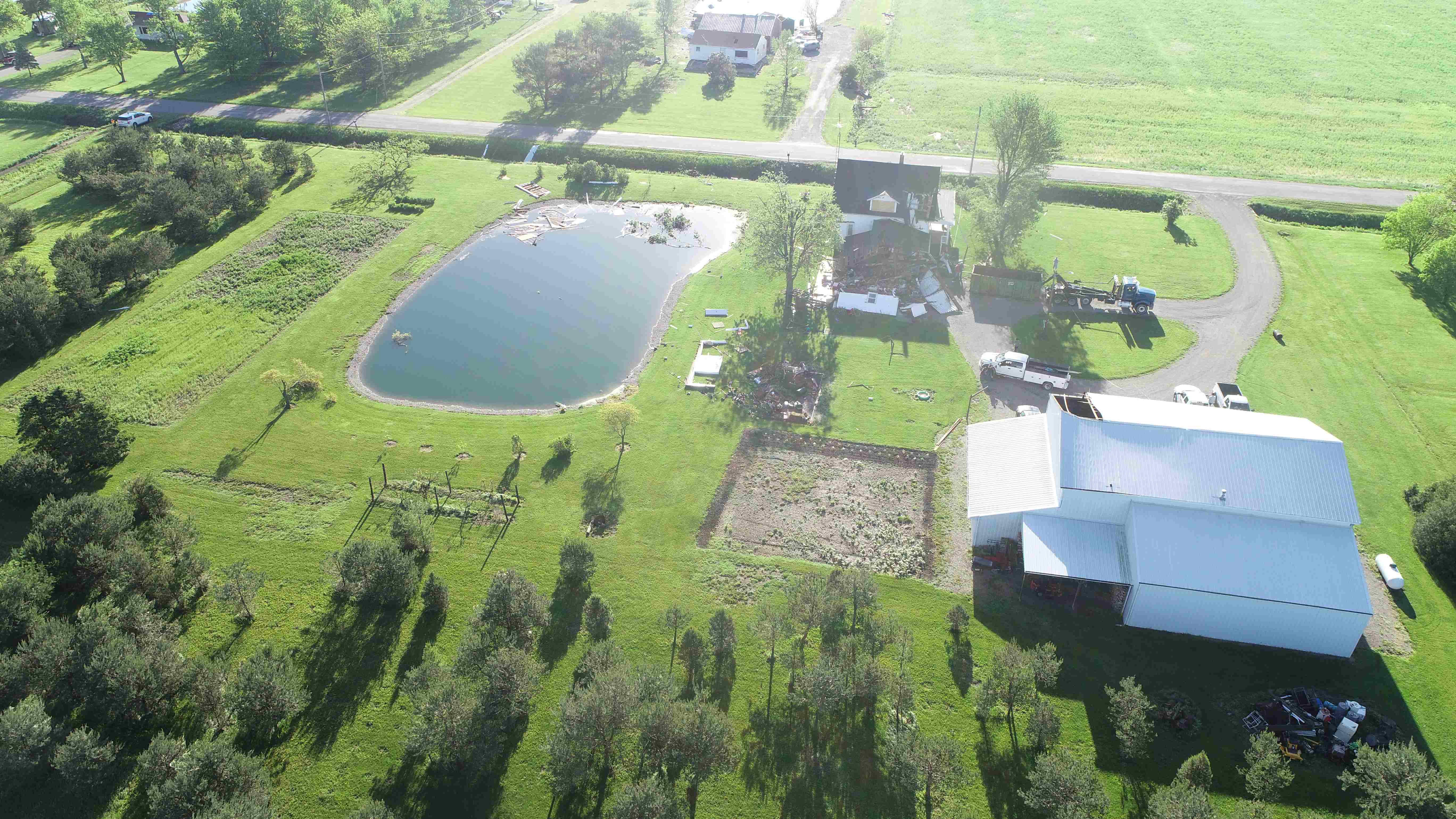
0809 PM Tornado 2 W Melrose 41.09N 84.46W
05/07/2024 Paulding OH NWS Storm Survey
Corrects time of previous tornado report
from 2 W Melrose. Additional review by
emergency management and NWS found damage
near Belmore, so the time and path length of
the tornado was updated accordingly. Several
reports of funnel clouds and a touchdown
were received from near Latty east to south
of Melrose and west of Oakwood. The most
extensive damage occurred north of Road 82,
along Road 151 where several structures were
impacted. The total path length was extended
to 6.18 miles as the tornado was on the
ground for 5 minutes.
0813 PM Tornado Oakwood 41.09N 84.39W
05/07/2024 Paulding OH Trained Spotter
Report of tornado with visible soil lofted
along Highway 613 west of Oakwood.
0816 PM Tornado 3 SSW Arthur 41.16N 84.39W
05/07/2024 Paulding OH NWS Storm Survey
Emergency management sent drone footage
which shows scoured dirt through a freshly
plowed field along Road 166 between Road 191
and Ohio 66. The track terminates near a
large metal outbuilding (at the intersection
of OH 66 and Road 158) which lost about half
of its metal roof panels on the north-facing
side, and about 1/4 of its panels on the
south facing side. The tornado was on the
ground for a minute and the damage path was
about a half mile. Rated EF-0 with maximum
winds 70 mph.
0830 PM Funnel Cloud Melrose 41.09N 84.42W
05/07/2024 Paulding OH Public
Video of a funnel cloud on X/Twitter from
Melrose, OH. Time estimated by radar.
0830 PM Funnel Cloud Broughton 41.09N 84.54W
05/07/2024 Paulding OH Public
Facebook photos shows a funnel cloud nearly
on the ground in Broughton. Time estimated
by radar.
0834 PM Funnel Cloud 2 W Delta 41.59N 84.04W
05/07/2024 Fulton OH Public
Delayed Report.
0836 PM Tornado 2 E Oakwood 41.09N 84.34W
05/07/2024 Putnam OH Public
Photo on X/Twitter between Melrose and
Leipsic of a tornado on the ground. Time
estimated by radar.
0840 PM Tornado Oakwood 41.09N 84.38W
05/07/2024 Paulding OH Public
Numerous photos on Facebook of a funnel
cloud nearly on the ground between Melrose
and Oakwood. Additional photos show the
tornado on the ground near Oakwood. Fairly
certain that a brief tornado touched down
between Melrose and Oakwood. Time estimated
by radar.
0854 PM Tornado 2 S Belmore 41.12N 83.94W
05/07/2024 Putnam OH NWS Storm Survey
A trained spotter reported a brief tornado
touched down south of Belmore, OH at 8:54 PM
EDT May 7th. Videos confirm that a tornado
did touch down in a field just east of
Little Yellow Creek, south of Iams Avenue
and west of Road 4. The tornado was on the
ground for less than a minute. It dissipated
over the field and did not cause any known
damage.
Rain Reports
Public Information Statement
National Weather Service Northern Indiana
1208 PM EDT Wed May 8 2024

...24 HOUR PRECIPITATION REPORTS...

Location                     Amount    Time/Date       Lat/Lon

...Indiana...

...Adams County...
0.8 N Linn Grove             0.15 in   1045 PM 05/07   40.66N/85.03W
0.8 N Linn Grove             0.14 in   1145 AM 05/08   40.66N/85.03W

...Allen County...
2 S New Haven                1.73 in   1110 PM 05/07   41.04N/85.02W
4 WNW Hessen Cassel          1.45 in   1108 PM 05/07   40.99N/85.15W
Fort Wayne International Ap  1.38 in   1054 PM 05/07   40.98N/85.18W
Fort Wayne International Ap  1.38 in   1154 AM 05/08   40.98N/85.18W
Ellisville 0.3 W             0.86 in   0730 AM 05/08   41.02N/85.29W
Fort Wayne 10.1 WSW          0.80 in   0700 AM 05/08   41.03N/85.32W
Fort Wayne 2.6 NW            0.80 in   0700 AM 05/08   41.10N/85.18W
Fort Wayne 7.1 WSW           0.72 in   0800 AM 05/08   41.05N/85.27W
Woodburn 2.8 WSW             0.65 in   0700 AM 05/08   41.12N/84.91W
Fort Wayne 2.6 NE            0.57 in   0700 AM 05/08   41.10N/85.11W
Fort Wayne 10.4 N            0.53 in   0700 AM 05/08   41.22N/85.14W
Fort Wayne 4.1 NE            0.48 in   0700 AM 05/08   41.12N/85.09W
Fort Wayne 7.5 NNW           0.43 in   0800 AM 05/08   41.17N/85.21W
Fort Wayne 1.6 S             0.41 in   0700 AM 05/08   41.05N/85.14W
Fort Wayne 6.8 NE            0.40 in   0700 AM 05/08   41.13N/85.03W
SPENCERVILLE                 0.35 in   1200 PM 05/08   41.25N/84.89W
SPENCERVILLE                 0.34 in   1100 PM 05/07   41.25N/84.89W
Woodburn 2.6 NNW             0.33 in   0900 AM 05/08   41.16N/84.88W
Fort Wayne 1.9 S             0.32 in   0445 AM 05/08   41.05N/85.14W
Fort Wayne 6.0 N             0.29 in   0700 AM 05/08   41.16N/85.13W
4 S Tuckers Corner           0.25 in   1105 PM 05/07   40.99N/84.94W
4 S Tuckers Corner           0.24 in   1155 AM 05/08   40.99N/84.94W
Harlan 3.4 NE                0.17 in   0700 AM 05/08   41.23N/84.87W
Hoagland 1.5 SSW             0.13 in   0700 AM 05/08   40.93N/85.00W

...Blackford County...
(KA9VIS) Hartford City 0.7 N 0.32 in   0700 AM 05/08   40.46N/85.37W

...Cass County...
Young America                0.50 in   0800 AM 05/08   40.57N/86.33W
Walton                       0.30 in   1100 PM 05/07   40.66N/86.22W
Walton                       0.23 in   1146 AM 05/08   40.66N/86.22W
Galveston                    0.22 in   1100 PM 05/07   40.56N/86.19W

...De Kalb County...
Corunna 1.1 S                0.59 in   0700 AM 05/08   41.42N/85.15W
1.7 SE Butler                0.28 in   0920 AM 05/08   41.41N/84.85W
0.6 S Garrett                0.24 in   0700 AM 05/08   41.34N/85.13W
Garrett                      0.21 in   1110 PM 05/07   41.33N/85.13W
Auburn 1.1 NNE               0.20 in   0700 AM 05/08   41.38N/85.05W
Garrett                      0.19 in   1200 PM 05/08   41.33N/85.13W
Auburn 0.2 SE                0.17 in   0800 PM 05/07   41.36N/85.05W
Hamilton 3.0 ESE             0.17 in   0700 AM 05/08   41.52N/84.86W

...Elkhart County...
Jamestown                    0.63 in   1108 PM 05/07   41.64N/86.04W
Elkhart 4.8 SW               0.58 in   0600 AM 05/08   41.64N/86.04W
Jamestown                    0.46 in   1200 PM 05/08   41.64N/86.04W
Elkhart 3.0 SSE              0.40 in   0700 AM 05/08   41.65N/85.94W
Wakarusa 2.4 NNE             0.34 in   0700 AM 05/08   41.57N/85.99W
Goshen 1.4 SSE               0.33 in   0700 AM 05/08   41.56N/85.83W
Goshen 6.8 NE                0.31 in   0700 AM 05/08   41.65N/85.75W
Goshen 4.6 N                 0.28 in   0700 AM 05/08   41.64N/85.83W
Goshen 1.8 SE                0.28 in   0700 AM 05/08   41.56N/85.81W
Goshen 0.3 NE                0.27 in   0700 AM 05/08   41.58N/85.83W
Goshen 3.0 WSW               0.27 in   0700 AM 05/08   41.56N/85.88W
Goshen 3 SW                  0.26 in   0700 PM 05/07   41.56N/85.88W
Goshen 1.2 SW                0.25 in   0700 AM 05/08   41.57N/85.85W
Elkhart 3.5 ENE              0.25 in   0800 AM 05/08   41.70N/85.90W
Goshen 2.3 WNW               0.23 in   0700 AM 05/08   41.59N/85.88W
Goshen 3.5 NNW               0.22 in   0700 AM 05/08   41.62N/85.87W
New Paris 1.0 SW             0.18 in   0700 AM 05/08   41.49N/85.84W
Ligonier 4.3 WNW             0.17 in   0800 AM 05/08   41.48N/85.67W
Goshen                       0.13 in   1053 PM 05/07   41.53N/85.78W

...Fulton County...
Kewanna 4.9 S                0.46 in   0700 AM 05/08   40.95N/86.41W
Rochester                    0.35 in   0700 AM 05/08   41.07N/86.21W
Rochester 2.4 NW             0.19 in   0700 AM 05/08   41.09N/86.23W
Rochester                    0.17 in   1055 PM 05/07   41.07N/86.18W

...Grant County...
1 NE Upland                  1.14 in   1113 PM 05/07   40.47N/85.50W
(KB9CRA)Gas City 0.3 N       0.73 in   0700 AM 05/08   40.49N/85.61W
(KD9CQQ)Upland 0.7 ENE       0.68 in   0700 AM 05/08   40.47N/85.50W
Grant County Municipal Apt   0.61 in   1055 PM 05/07   40.48N/85.68W
Grant County Municipal Apt   0.60 in   1155 AM 05/08   40.48N/85.68W
(KC9QCJ) Shamrock Lakes 3.0  0.24 in   0700 AM 05/08   40.45N/85.45W
Upland 2.4 SSE               0.21 in   0700 AM 05/08   40.43N/85.50W
2.2 N Marion                 0.17 in   0700 AM 05/08   40.58N/85.66W

...Huntington County...
1.7 E Bowerstown             1.60 in   1100 AM 05/08   40.90N/85.41W
1.7 E Bowerstown             1.25 in   1100 PM 05/07   40.90N/85.41W
Huntington                   0.57 in   1055 PM 05/07   40.85N/85.45W
Huntington                   0.57 in   1155 AM 05/08   40.85N/85.45W
Huntington 0.3 W             0.45 in   0700 AM 05/08   40.88N/85.51W
Huntington                   0.33 in   1108 PM 05/07   40.83N/85.53W
Huntington                   0.30 in   1158 AM 05/08   40.83N/85.53W

...Jay County...
(KB9PPK) Redkey 0.5 SE       0.25 in   0700 AM 05/08   40.34N/85.15W
Redkey 0.6 SE                0.23 in   0647 AM 05/08   40.34N/85.14W
(W9JKL) Portland 0.6 SSW     0.17 in   0700 AM 05/08   40.42N/84.99W
(KC9LQY) Portland 5.4 SW     0.15 in   0700 AM 05/08   40.39N/85.06W
Portland 2.3 S               0.13 in   0700 AM 05/08   40.40N/84.98W

...Kosciusko County...
Pierceton 2.8 NNE            0.42 in   0701 AM 05/08   41.23N/85.68W
1 SSE Clunette               0.22 in   1105 PM 05/07   41.31N/85.92W
Leesburg 0.1 WNW             0.22 in   0600 AM 05/08   41.33N/85.85W
Claypool 1.2 E               0.19 in   0625 AM 05/08   41.13N/85.86W
Warsaw 1.2 NNE               0.19 in   0700 AM 05/08   41.25N/85.84W
Leesburg 6.7 ESE             0.18 in   0700 AM 05/08   41.31N/85.72W
1 SSE Clunette               0.18 in   1155 AM 05/08   41.31N/85.92W
North Webster 2.3 N          0.17 in   0800 AM 05/08   41.36N/85.70W
2.3 N North Webster          0.16 in   0800 AM 05/08   41.36N/85.70W
Warsaw Muni                  0.14 in   1055 PM 05/07   41.27N/85.83W
Milford 2.7 SSW              0.14 in   0600 AM 05/08   41.38N/85.87W
Cromwell 2.9 W               0.14 in   0700 AM 05/08   41.40N/85.67W
Syracuse 3.0 ESE             0.12 in   0800 AM 05/08   41.41N/85.70W
Milford 0.9 N                0.11 in   0700 AM 05/08   41.42N/85.85W

...La Porte County...
La Porte 9.2 N               0.42 in   0800 AM 05/08   41.74N/86.70W
Michigan City 5.4 S          0.37 in   0800 AM 05/08   41.63N/86.88W
Mill Creek 1.9 NNE           0.35 in   0620 AM 05/08   41.61N/86.52W
La Porte 1.6 SW              0.26 in   0800 AM 05/08   41.59N/86.73W
0.8 W La Porte               0.23 in   1258 AM 05/08   41.61N/86.73W
Westville 2.6 N              0.22 in   0733 AM 05/08   41.58N/86.90W
La Porte 5.9 NW              0.22 in   0800 AM 05/08   41.66N/86.80W
La Porte 0.9 SSE             0.13 in   0800 AM 05/08   41.60N/86.71W
La Crosse 1.2 W              0.13 in   0800 AM 05/08   41.32N/86.91W
La Porte                     0.11 in   1055 PM 05/07   41.57N/86.73W
La Porte 5.8 SSE             0.10 in   0700 PM 05/07   41.53N/86.66W

...Lagrange County...
Lagrange 9.6 ESE             0.57 in   0700 AM 05/08   41.59N/85.24W
Orland 6.6 SSW               0.52 in   0730 AM 05/08   41.64N/85.20W
Wolcottville 1.1 WNW         0.36 in   0756 AM 05/08   41.53N/85.39W
Lagrange 4.6 ESE             0.33 in   0810 AM 05/08   41.62N/85.34W
LaGrange 9.9 E               0.29 in   0730 AM 05/08   41.65N/85.23W
LaGrange 1.3 ENE             0.29 in   0800 AM 05/08   41.65N/85.40W

...Marshall County...
Bremen 3.9 WSW               0.31 in   0833 PM 05/07   41.43N/86.23W
Plymouth 2.5 WSW             0.28 in   0500 AM 05/08   41.33N/86.36W
Culver 1.0 NNW               0.17 in   0700 AM 05/08   41.23N/86.43W
Tippecanoe 0.8 S             0.17 in   0700 AM 05/08   41.20N/86.11W
1.2 W Plymouth               0.13 in   1045 PM 05/07   41.34N/86.34W

...Miami County...
0.8 NW Peru                  0.48 in   0700 AM 05/08   40.76N/86.07W
Macy 3.6 SSE                 0.45 in   0800 AM 05/08   40.91N/86.10W
Peru 0.2 NNE                 0.41 in   0715 AM 05/08   40.76N/86.07W
Macy 2.7 SSE                 0.40 in   0700 AM 05/08   40.92N/86.12W
Peru 5.8 N                   0.36 in   0700 AM 05/08   40.84N/86.08W
Denver 0.5 SSE               0.35 in   0700 AM 05/08   40.86N/86.07W
Grissom AFB Peru             0.32 in   0855 PM 05/07   40.63N/86.15W
Grissom AFB Peru             0.32 in   0555 AM 05/08   40.63N/86.15W
Peru                         0.30 in   1130 AM 05/08   40.75N/86.07W
Peru                         0.29 in   1030 PM 05/07   40.75N/86.07W
Denver 1.3 NE                0.27 in   0700 AM 05/08   40.88N/86.06W
Amboy                        0.12 in   1100 PM 05/07   40.59N/85.98W

...Noble County...
Albion 0.5 N                 0.60 in   0600 AM 05/08   41.40N/85.42W
Albion 2.9 S                 0.30 in   0900 AM 05/08   41.35N/85.42W
Avilla 3 SW                  0.29 in   0300 PM 05/07   41.35N/85.30W
Cosperville                  0.28 in   1030 PM 05/07   41.48N/85.48W
Cosperville                  0.19 in   1130 AM 05/08   41.48N/85.48W
Kendallville 4.5 NW          0.18 in   0700 AM 05/08   41.50N/85.31W

...Pulaski County...
Monterey 2.2 WNW             0.11 in   0800 AM 05/08   41.17N/86.52W

...St. Joseph County...
South Bend 3.3 SE            0.58 in   0645 AM 05/08   41.64N/86.23W
Granger 1.8 ENE              0.58 in   0700 AM 05/08   41.75N/86.11W
Mishawaka 2.0 E              0.53 in   0700 AM 05/08   41.66N/86.13W
Mishawaka 3.9 ENE            0.52 in   0800 AM 05/08   41.68N/86.10W
South Bend 4.6 SSE           0.48 in   0827 AM 05/08   41.61N/86.24W
South Bend 4.6 SE            0.47 in   0700 AM 05/08   41.62N/86.22W
New Carlisle                 0.31 in   0730 AM 05/08   41.71N/86.50W
Walkerton 5.7 ENE            0.29 in   0700 AM 05/08   41.50N/86.39W
South Bend 4.0 SSW           0.18 in   0800 AM 05/08   41.63N/86.31W
Lakeville 1.5 SSW            0.12 in   0727 AM 05/08   41.51N/86.28W
South Bend 4.0 NNE           0.12 in   0831 AM 05/08   41.72N/86.23W

...Starke County...
3.5 N Brems                  0.20 in   1100 PM 05/07   41.39N/86.71W
Winona                       0.10 in   0800 AM 05/08   41.24N/86.57W

...Steuben County...
Hudson 0.3 SE                0.80 in   0523 AM 05/08   41.53N/85.08W
Angola 8.7 ESE               0.60 in   0700 AM 05/08   41.61N/84.84W
Angola 8.8 ESE               0.58 in   0800 AM 05/08   41.62N/84.83W
Angola 1.2 S                 0.54 in   0600 AM 05/08   41.62N/85.00W
Angola 4.1 N                 0.53 in   0545 AM 05/08   41.70N/84.99W
Angola                       0.46 in   0630 AM 05/08   41.64N/84.99W
Angola 4.5 NW                0.38 in   0700 AM 05/08   41.68N/85.07W
Hamilton 1.7 E               0.37 in   0700 AM 05/08   41.53N/84.89W
Hudson 4.1 NNW               0.37 in   0700 AM 05/08   41.59N/85.10W
Hudson 4.6 N                 0.37 in   0715 AM 05/08   41.60N/85.09W
Pigeon Creek                 0.33 in   1115 AM 05/08   41.63N/85.11W
Pigeon Creek                 0.32 in   1015 PM 05/07   41.63N/85.11W
Hudson 6.4 WNW               0.26 in   0800 AM 05/08   41.58N/85.19W
Angola 6.2 NW                0.25 in   0700 AM 05/08   41.71N/85.07W

...Wabash County...
Wabash 0.3 NNW               0.60 in   0600 AM 05/08   40.80N/85.83W
3.0 SE Lagro                 0.26 in   1015 PM 05/07   40.81N/85.68W
3.0 SE Lagro                 0.26 in   1115 AM 05/08   40.81N/85.68W
La Fontaine 1.1 NW           0.25 in   0600 AM 05/08   40.68N/85.74W
0.7 SE Wabash                0.18 in   1030 PM 05/07   40.79N/85.82W
0.7 SE Wabash                0.18 in   1130 AM 05/08   40.79N/85.82W

...Wells County...
Bluffton 0.9 SE              0.18 in   0700 AM 05/08   40.73N/85.16W
Bluffton                     0.15 in   1045 PM 05/07   40.74N/85.17W
Bluffton                     0.13 in   1145 AM 05/08   40.74N/85.17W

...White County...
Idaville 0.2 SW              0.62 in   0700 AM 05/08   40.76N/86.65W
Brookston 0.3 SE             0.29 in   0700 AM 05/08   40.60N/86.86W
Norway                       0.25 in   1045 PM 05/07   40.78N/86.76W
Norway                       0.16 in   1145 AM 05/08   40.78N/86.76W
Burnettsville 9.9 NNW        0.13 in   1024 AM 05/08   40.90N/86.65W
5.6 N Badger Grove           0.10 in   0700 AM 05/08   40.67N/86.95W

...Whitley County...
Columbia City 5.4 N          0.93 in   0700 AM 05/08   41.24N/85.49W
Tri-Lakes 3.0 N              0.78 in   0700 AM 05/08   41.26N/85.49W
Columbia City 7.4 N          0.61 in   0700 AM 05/08   41.26N/85.50W
Columbia City 0.5 WSW        0.48 in   0600 AM 05/08   41.16N/85.49W
Columbia City 0.2 NE         0.37 in   0636 AM 05/08   41.16N/85.48W
Columbia City 4.6 S          0.28 in   0600 AM 05/08   41.09N/85.47W
South Whitley 2.6 SE         0.20 in   0729 AM 05/08   41.06N/85.59W

...Michigan...

...Berrien County...
1 NNW Coloma                 1.70 in   1058 PM 05/07   42.20N/86.32W
3 WNW Sodus                  1.46 in   1054 PM 05/07   42.05N/86.42W
Stevensville 1.7 SSE         1.44 in   0520 AM 05/08   41.99N/86.51W
1 ENE Saint Joseph           1.39 in   1056 PM 05/07   42.10N/86.48W
St. Joseph 2.8 SSE           1.03 in   0700 AM 05/08   42.06N/86.47W
Benton Harbor                1.02 in   1053 PM 05/07   42.13N/86.42W
Shoreham 2.0 SE              0.95 in   0800 AM 05/08   42.03N/86.49W
3.7 S Watervliet             0.92 in   1000 PM 05/07   42.13N/86.25W
3.7 S Watervliet             0.92 in   1100 AM 05/08   42.13N/86.25W
Benton Harbor                0.90 in   1153 AM 05/08   42.13N/86.42W
St. Joseph 1.5 SSE           0.75 in   0600 AM 05/08   42.08N/86.48W
Niles 2.7 W                  0.36 in   0800 AM 05/08   41.84N/86.30W
Buchanan 1.4 ESE             0.30 in   0700 AM 05/08   41.82N/86.34W
Niles                        0.29 in   1106 PM 05/07   41.83N/86.25W
Niles                        0.20 in   1159 AM 05/08   41.83N/86.25W

...Branch County...
QUINCY                       0.28 in   1110 PM 05/07   41.94N/84.90W
QUINCY                       0.28 in   1200 PM 05/08   41.94N/84.90W
Quincy 0.3 NE                0.19 in   0700 AM 05/08   41.95N/84.88W

...Cass County...
Cassopolis 9.0 SSE           0.93 in   0700 AM 05/08   41.79N/85.95W
2 NNW Edwardsburg            0.21 in   0700 AM 05/08   41.84N/86.10W

...Hillsdale County...
2 S Hillsdale                1.24 in   1102 PM 05/07   41.90N/84.64W
Hillsdale 2.5 ESE            1.11 in   0800 AM 05/08   41.91N/84.59W
Hillsdale                    0.80 in   1155 AM 05/08   41.92N/84.58W
Hillsdale                    0.78 in   1055 PM 05/07   41.92N/84.58W
Osseo 2.7 NE                 0.62 in   0830 AM 05/08   41.90N/84.49W
Jonesville 5.9 ENE           0.44 in   0600 AM 05/08   42.01N/84.56W

...St. Joseph County...
Fishers Lake                 1.56 in   1100 PM 05/07   41.99N/85.58W
Three Rivers 2.4 NE          1.43 in   0700 AM 05/08   41.97N/85.60W
2.0 SE Mendon                0.39 in   1000 PM 05/07   41.98N/85.43W
2.0 SE Mendon                0.39 in   1100 AM 05/08   41.98N/85.43W
Constantine 1.9 E            0.16 in   0700 AM 05/08   41.84N/85.63W
Sturgis Kirsch               0.11 in   1055 PM 05/07   41.80N/85.43W
Sturgis Kirsch               0.11 in   1155 AM 05/08   41.80N/85.43W

...Ohio...

...Allen County...
2 S Harrod                   1.33 in   1112 PM 05/07   40.68N/83.92W
Lima 7.3 SE                  1.22 in   0700 AM 05/08   40.66N/84.03W
2 WNW Westminster            0.38 in   1053 PM 05/07   40.71N/84.02W
Lima 3.0 SSE                 0.33 in   0600 AM 05/08   40.70N/84.10W
Lima 1 N                     0.22 in   1108 PM 05/07   40.78N/84.12W
Lima 1 N                     0.22 in   1159 AM 05/08   40.78N/84.12W
Delphos 2.3 ESE              0.16 in   0600 AM 05/08   40.83N/84.30W
Lima 2.7 NE                  0.14 in   0700 AM 05/08   40.77N/84.08W

...Defiance County...
Defiance                     0.24 in   1153 AM 05/08   41.33N/84.43W
Defiance                     0.23 in   1053 PM 05/07   41.33N/84.43W

...Fulton County...
Swanton 4.0 S                0.25 in   0722 AM 05/08   41.53N/83.91W
Fayette 4.3 ESE              0.18 in   0700 AM 05/08   41.65N/84.25W

...Henry County...
New Bavaria 2.3 WSW          0.92 in   0700 AM 05/08   41.19N/84.21W
DESHLER                      0.81 in   1200 PM 05/08   41.20N/83.89W
DESHLER                      0.80 in   1100 PM 05/07   41.20N/83.89W
Napoleon 1.2 SSE             0.29 in   0700 AM 05/08   41.38N/84.12W
Liberty Center 0.3 NE        0.19 in   0700 AM 05/08   41.45N/84.00W
Napoleon 1 SW                0.17 in   0715 AM 05/08   41.38N/84.15W
Napoleon 0.6 WSW             0.15 in   0800 AM 05/08   41.39N/84.14W
Napoleon 4.5 NNW             0.14 in   0700 AM 05/08   41.46N/84.15W

...Paulding County...
Paulding 1.4 NNE             0.99 in   0700 AM 05/08   41.15N/84.57W
Paulding 5.6 ESE             0.20 in   0700 AM 05/08   41.09N/84.49W

...Putnam County...
Leipsic 5.4 W                0.20 in   0700 AM 05/08   41.11N/84.09W
Ottawa 1.0 N                 0.15 in   0700 AM 05/08   41.04N/84.04W
Ottawa 1.2 ENE               0.14 in   0736 AM 05/08   41.03N/84.02W
Vaughnsville                 0.10 in   1105 PM 05/07   40.88N/84.15W
Vaughnsville                 0.10 in   1155 AM 05/08   40.88N/84.15W

...Van Wert County...
1 WNW Convoy                 0.30 in   1105 PM 05/07   40.93N/84.74W
1 WNW Convoy                 0.23 in   1155 AM 05/08   40.93N/84.74W
2 N Wetsel                   0.19 in   1105 PM 05/07   40.98N/84.44W
2 N Wetsel                   0.19 in   1155 AM 05/08   40.98N/84.44W
Van Wert                     0.13 in   1109 PM 05/07   40.87N/84.59W
Van Wert                     0.13 in   1200 PM 05/08   40.87N/84.59W

...Williams County...
Alvordton 0.5 E              0.35 in   0700 AM 05/08   41.67N/84.42W
3 S Nettle Lake              0.31 in   1155 AM 05/08   41.63N/84.73W
3 S Nettle Lake              0.30 in   1105 PM 05/07   41.63N/84.73W

Observations are collected from a variety of sources with varying
equipment and exposures. We thank all volunteer weather observers
for their dedication. Not all data listed are considered official.

$$
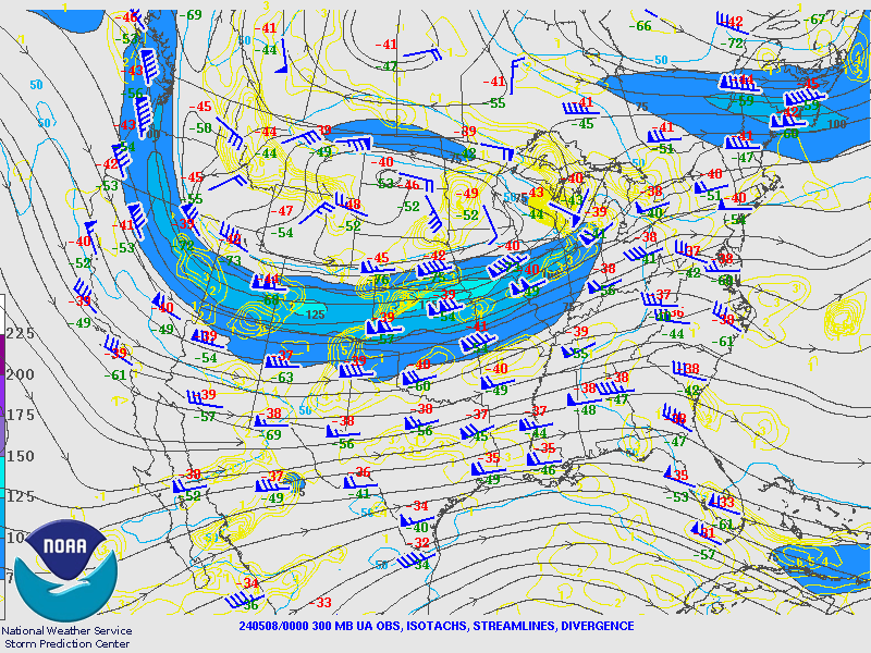
Environment
A potent upper level system across the Northern Plains had several short waves ejecting into the Great Lakes region. Southwesterly winds transported warm and moist air northward ahead of these disturbances. The combination of surface temperatures in the 70s to around 80 and high surface dew point set the stage for unstable conditions. This instability combined with strong wind profiles provided a favorable environment for tornadic storms and very large hail.
 |
.gif) |
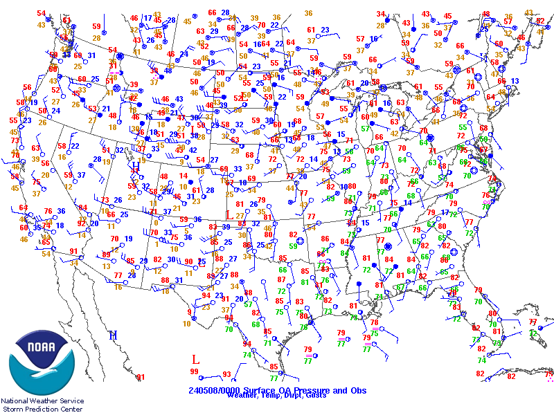 |
| Figure 1: 300 mb analysis valid 5/7/24 8pm. The key feature was a 120 knot upper jet streak nosing into the southern Great Lakes. Thunderstorms often initiate at the nose of these jet streaks. | Figure 2: 850 mb analysis valid 5/724 8pm. A low level warm front was lifting across the southern Great Lakes at this time. Increased low level moisture and wind profiles favorable for supercells often accompany the warm front. | Figure 3: Surface analysis valid 5/27/24 8pm. Unseasonably high dew points in the mid 60s to around 70 build into central Illinois and central Indiana. The combination of warm temperatures and high dew points were favorable for storms. |
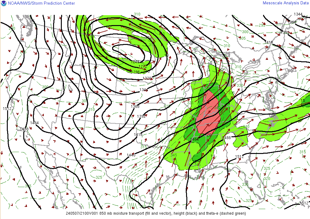
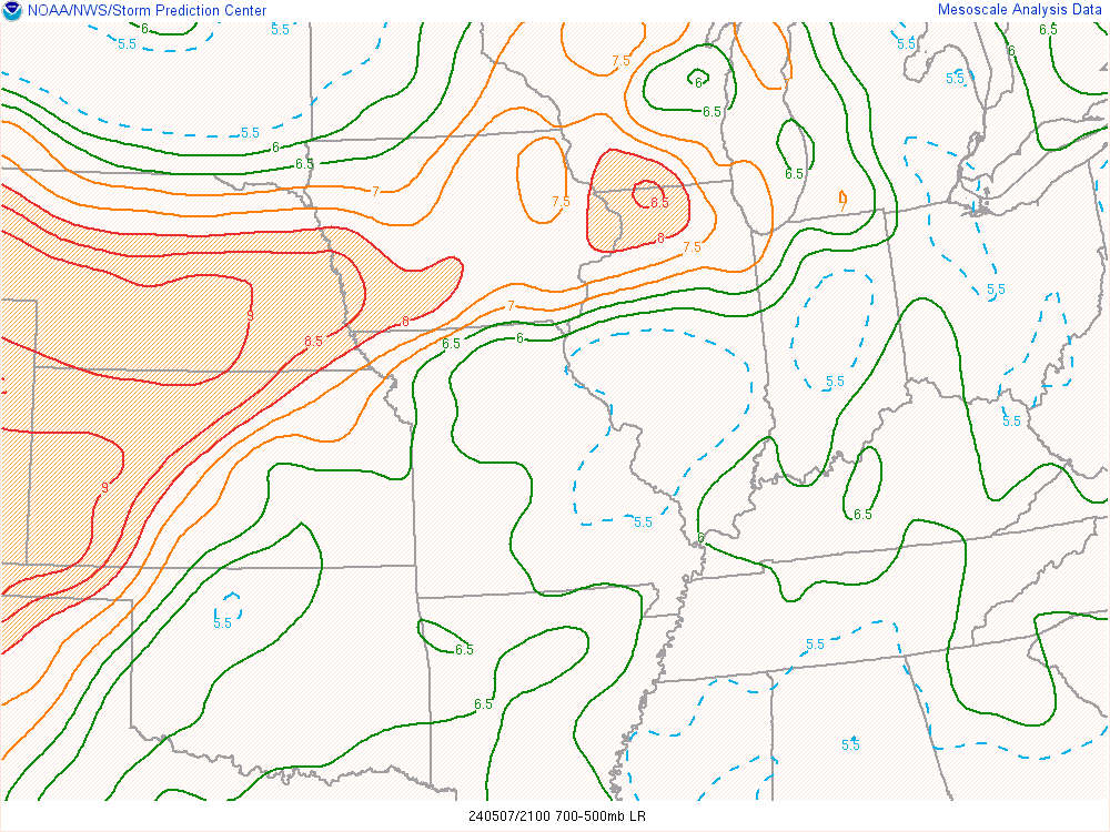
Near-storm environment summary.
 |
 |
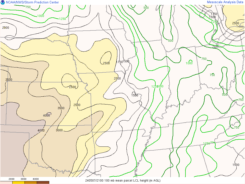 |
| Figure 4: RAP 850 mb moisture transport valid 5/7/24 8pm. The longer arrows depict strong low level moisture advection into the region. | Figure 5: RAP 700-500 mb lapse rates valid 5/7/24 8pm. Mid level lapse rates around 7 deg C/km nosed into far northern Indiana and southern Lower Michigan. These type of lapse rates support large hail. | Figure 6: RAP Lifting Condensation Level (LCL) valid 5/7/24 8pm. LCLs were were lowest across far northern Indiana/southern Lower Michigan/extreme northwest Ohio. Lower LCLs (lower clouds bases) can support tornadoes if other ingredients exist. |
 |
 |
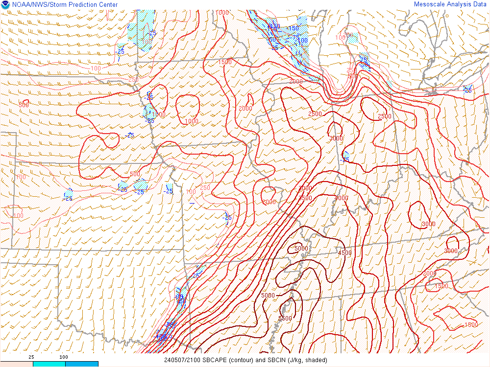 |
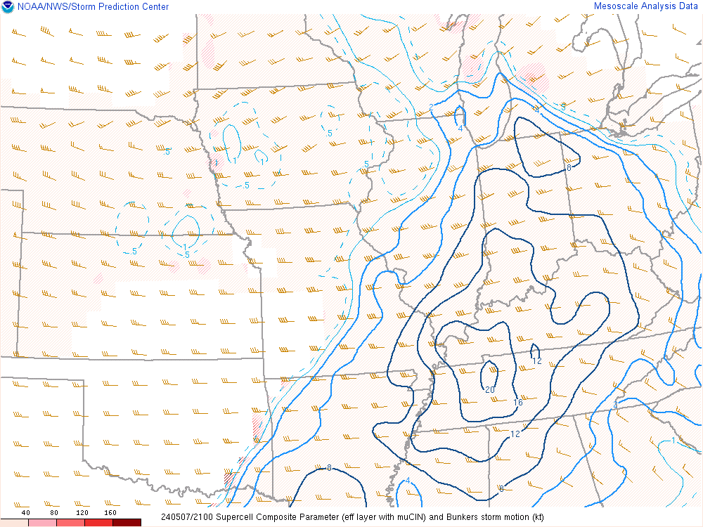
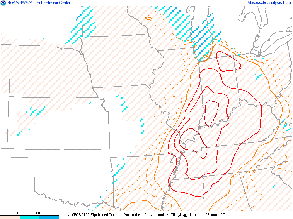
| Figure 7: RAP Supercell Composite Parameter (SCP) valid 5/7/24 8pm. SCP values greater than 5 indicate a greater potential of supercells. | Figure 8: RAP Significant Tornado Parameter (STP) valid 5/7/24 8pm. STP values of 1 or greater typically indicate a greater potential of significant tornadoes (EF-2 or greater). | Figure 9: RAP surface-based Convective Available Potential Energy (CAPE) valid 5/7/24 8pm. CAPE values increased to 2-3000 J/kg indicate high amounts of instability for storms to work with. |
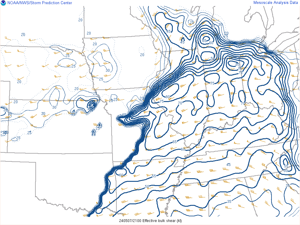
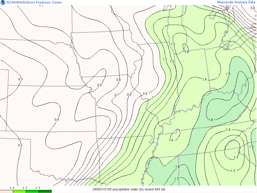
Additional environmental data.
 |
 |
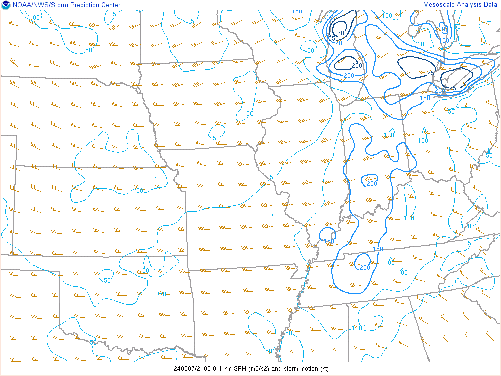 |
| Figure 10: RAP Effective shear valid 5/7/24 8pm. Effective shear was greater than 60 knots across much of the region. This high level of shear supports storm organization and supercells. | Figure 11: RAP Precipitable water (PWAT) valid 5/7/24 at 8pm. An axis of 1.4 inch PWATs noised into the southern Great Lakes indicating a high amount of moisture. | Figure 12: RAP 0-1 Storm Relative Helicity (SRH) valid 5/7/24 8pm. 0-1 km SRH values in excess of 100 m2/s2 generally indicate greater tornado potential. Greatest values were across S Lower MI. |
 |
Media use of NWS Web News Stories is encouraged! Please acknowledge the NWS as the source of any news information accessed from this site. |
|