 |
|||||
Summary of the National Outbreak
Moisture-rich tropical air covered the southeastern United States from Texas eastward to Georgia and northward to the Ohio River Valley. Tremendous energy was released in this unseasonably warm and unstable air mass as a low pressure center entered Texas from the west. This setup resulted in a three day severe weather outbreak that was unusually widespread and intense. It covered 13 states, beginning in southeast Texas during the early afternoon of Saturday, November 21st 1992 and ending Monday morning, November 23rd along the central portion of the Atlantic Seaboard. This outbreak produced 94 tornadoes and was responsible for 26 deaths and 641 injuries.

Image courtesy of NWS Raleigh NC
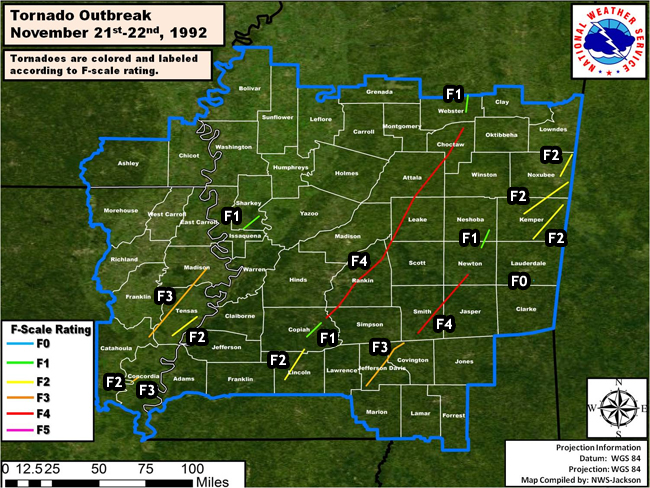
Summary of the ArkLaMiss Outbreak
Mississippi was dealt the hardest blow during this tornado outbreak. There were 15 fatalities (10 in Rankin County, 2 in Webster County,1 in Leake County, 1 in Choctaw County, and 1 in Kemper County) and 269 injuries. Nearly 300 homes were destroyed and over 700 damaged, with 21 counties declared disaster areas.Nearly all of the damage occurred with two storm cells that entered south Mississippi and tracked northeast into central and northeast Mississippi.
The first storm crossed Lincoln and Copiah Counties, producing two short track tornadoes. The beginning of a long track that included a violent tornado touched down in northeast Copiah County and tracked across northeast Simpson, Rankin, northwest Scott into Attala County before lifting. The same storm then produced several short track tornadoes across Choctaw, Webster, and Chickasaw Counties.
The second storm entered Lawrence County then produced a strong tornado in southwest Jefferson Davis County that moved into northwest Covington County and lifted in southwest Smith County. The storm then produced a violent tornado along a track from central Smith County that tracked across Jasper County and into south central Newton County. Several short track tornadoes were produced from this storm over Neshoba, Lauderdale, Kemper and Noxubee Counties before the storm moved into Alabama.
Several strong tornadoes tracked across northeast Louisiana. Two short track but strong tornadoes touched down near Monterey, one in Concordia Parish and another across the Black River in Catahoula Parish. A strong tornado with a 16 mile track moved across Tensas Parish. A longer track strong tornado touched down in Catahoula Parish and tracked to the northeast across Tensas and Madison Parishes.
ArkLaMiss Tornado Track Map
The map below shows the locations of surveyed tornado tracks across the ArkLaMiss region as determined by the National Weather Service. The graphic is followed by a table detailing each surveyed tornado track. Maps for individual tornadoes can be found on those subsequent pages.
Tornado Track Information - Click on the location in the table for additional details
| Location | Start/ End Time |
Event Type/ Max Winds |
Fatalities/ Injuries |
Path Length | Path Width |
| Catahoula Parish Parhams/1 WNW Monterey |
Sat 11/21 9:45 pm - 9:45 pm |
F2 Tornado | none | 1/2 mile | 100 yards |
| Concordia Parish Monterey to 4 NNE Monterey |
Sat 11/21 9:45 pm - 9:45 pm |
F3 Tornado | Deaths: 0 Injuries: 6 |
3 miles | 100 yards |
| Catahoula/Tensas/Madison Parishes Foules to Cooter Point to 4 SE Tallulah |
Sat 11/21 9:55 pm - 10:55 pm |
F3 Tornado | Deaths: 0 Injuries: 11 |
46 miles | 200 yards |
| Tensas Parish 2 W Goldman to 5 S Newellton |
Sat 11/21 10:18 pm - 10:32 pm |
F2 Tornado | none | 16 miles | 100 yards |
| Lincoln and Copiah Counties 2 E of West Lincoln to Wesson |
Sat 11/21 10:50 pm - 11:05 pm |
F2 Tornado | none | 18.7 miles | 1/4 mile |
| Copiah County 3 SSE Hazlehurst to 2 SW Hopewell |
Sat 11/21 11:15 pm - 11:24 pm |
F1 Tornado | none | 10 miles | 1/4 mile |
| Jefferson Davis and Covington Counties 8 SW Carson to 2 NE Mount Olive |
Sat 11/21 11:23 pm - Sun 11/22 12:05 am |
F3 Tornado | Deaths: 0 Injuries: 105+ |
29 miles | 1/2 mile |
| Copiah/Simpson/Rankin/Scott/Leake/ Attala/Choctaw Counties 1 N Hopewell to 4 SW Mathiston (Brandon/Florence/Weir) |
Sat 11/21 11:27 pm - Sun 11/22 2:01 am |
F4 Tornado | Deaths: 12 Injuries: 122 |
128 miles | 1/2 mile |
| Sharkey County 2 N Valley Park to 2 SW Holly Bluff |
Sat 11/21 11:30 pm- 11:38 pm |
F1 Tornado | Deaths: 0 Injuries: 4 |
10 miles | 1/4 mile |
| Smith/Jasper/Newton Counties 2 SE Mize to Newton (Sylvarena) |
Sun 11/22 12:14 am - 1:14 am |
F4 Tornado | Deaths: 0 Injuries: 20 |
40 miles | 1 mile |
| Newton and Neshoba Counties Little Rock to 2 N House |
Sun 11/22 1:22 am - 1:35 am |
F1 Tornado | none | 9 miles | 200 yards |
| Webster County 1 SW Clarkson to 3 W Woodland |
Sun 11/22 2:14 am - 2:25 am |
F1 Tornado | Deaths: 2 Injuries: 0 |
9 miles | 200 yards |
| Kemper and Noxubee Counties 3 NW De Kalb to 6 E Macon |
Sun 11/22 2:15 am - 2:55 am |
F2 Tornado | Deaths: 1 Injuries: 1 |
27 miles | 1/2 mile |
| Noxubee County 4 SSW Prairie Point to 2 NE Bigbee Valley |
Sun 11/22 2:45 am - 3:10 am |
F2 Tornado | Deaths: 0 Injuries: 15 |
13 miles | 1/4 mile |
| Kemper County 4 N Meridian Station to 5 ENE Scooba |
Sun 11/22 2:45 am - 3:20 am |
F2 Tornado | none | 23 miles | 1/2 mile |
| Lauderdale County 9 SE Meridian |
Sun 11/22 3:20 am- 3:22 am |
F0 Tornado | none | 2 miles | 100 yards |


 Follow us on YouTube