During the afternoon of Feb 3, 2006, a very potent upper level system moved through the region along with a strong cold front. Usually before severe weather events, the area is quite warm and humid. Not this time, this event was a bit different. Temperatures did warm up to the upper 60s and lower 70s ahead of the front, but area dew points only remained in the mid to upper 50s. Typically we see dew points well into the 60s for severe weather events. What we had instead of "high" moisture was very steep lapse rates! This is just how fast the air temperature cools off with height. Typically we cool at roughly 6 C per 1000 m. However on this day, we cooled at around 8 C per 1000 m. This set the stage for a rather unstable atmosphere and all we needed was something to get it going. Well, the strong cold front and potent upper level system was more than enough.
The storms developed over northern Louisiana shortly after noon and quickly became severe as they moved in an easterly direction. There were 3 main storms during this event. Due to the instability present and the amount of wind shear, these thunderstorms became supercell storms. These storms stayed intact as they moved just about across the entire state of MS. These supercells were very efficient hail producers. The southern of the two storms produced large swaths of quarter to golfball sized hail. These large hailstones damaged many cars, roofs and even punched holes in siding. By late afternoon, as the storms moved into eastern MS, the hail was still falling, but was generally smaller in size and began to mainly range from dime to nickel sized.
Below are some radar images of the storms which depict some impressive signatures and just how potent these storms were.
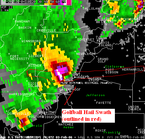
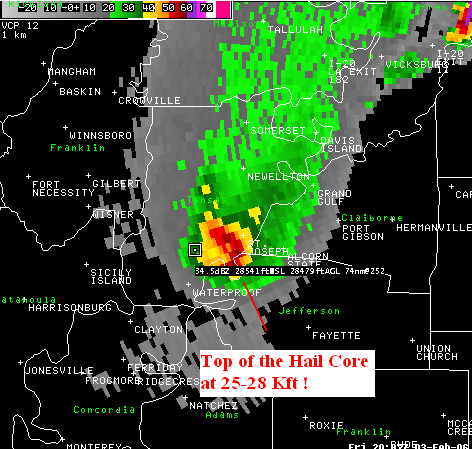
The following 2 images show the large supercell storm just before it reached St. Joseph, LA. This storm had been producing golfball sized hail just to the west and continued to do so all the way into Central MS. The red outline indicates the approximate swath of golfball sized hail.
 |
 |
Click for Full 4 Panel View of Storm
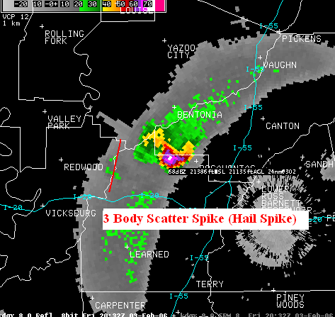
This next image is of another supercell storm which moved across northern Warren and Hinds county, as well as southern Madison county. Like the previous storm, this supercell also produce a large swath of golfball sized hail. The image below points out an interesting radar artifact! It is called a "Three Body Scatter Spike" It gets this name from the amount of time the radar beam is bounced off objects before it gets back to the radar. In simple terms it goes something like this: radar beam hits the large hail (1), then is reflected to the ground, hits the ground (2) and reflected back into the storm when it hits the large hail again (3) and finally goes back to the radar. Those are the (3) scatters. What we see as a result is a "weakened" signal back to the radar and the time lag from its trip to the ground. This time lag is why the radar image has the "spike" sticking out of the back of the storm. These "hail spikes" only occur with large hail, typically 1 inch or larger.
 |
Click for Full 4 Panel View of Storm

