Event Summary
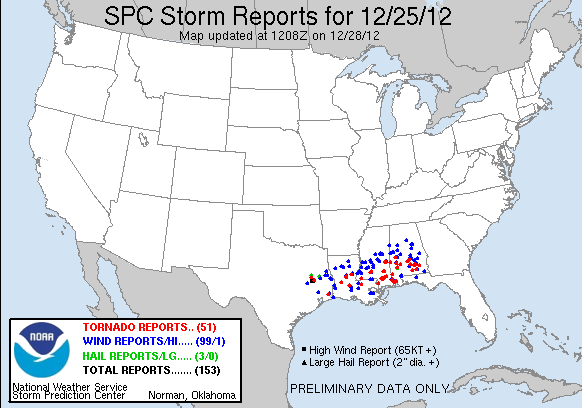
While the Deep South and the area known as "Dixie Alley" is accustomed to tornadoes during the winter months, the Christmas Day severe weather and tornado outbreak on December 25, 2012, served as a reminder of the potency that can be mother nature, no matter what the day. A regional severe weather outbreak including strong tornadoes, squall lines, and heavy rains impacted portions of Texas, Louisiana, Mississippi, and Alabama beginning Christmas morning through the late evening. Within NWS Jackson's area of responsibility, there were 13 injuries reported due to strong tornadoes and damaging straight-line winds.
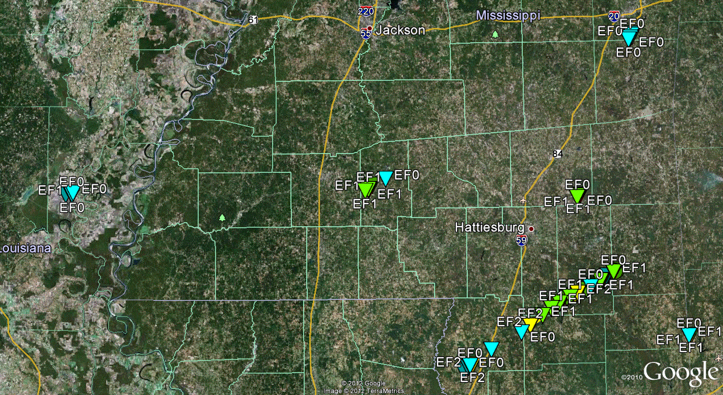
The regional severe weather outbreak was the result of an anomalously strong and southward positioned trough axis over the Southern Plains and Lower Mississippi River Valley. Very strong cyclonically curved winds in the mid-levels of the atmosphere near 100 knots (115 mph) and a rapidly deepening surface low pressure system over Louisiana and Mississippi aided in strong low-level wind shear and destabilization for severe thunderstorm development. During early Christmas morning, a large elevated rain and thunderstorm rain shield overspread the entire ArkLaMiss region. A warm front pushed north through southern Louisiana and Mississippi through late morning and through the afternoon while a quickly advancing cold front and developing squall line were occurring across portions of Texas and Louisiana. A Particularly Dangerous Situation (PDS) tornado watch was issued for all of southern Louisiana and Mississippi late Christmas morning for the expected potency of the rotating thunderstorms. Supercells began to develop ahead of the squall line across southern Louisiana, Mississippi, and Alabama south of the warm front during the afternoon. With such ample wind and speed shear, strong tornadoes developed that afternoon. The most notable tornadoes in NWS Jackson's area were two EF2 tornadoes in Lawrence and in southern Forrest counties that destroyed several mobile homes, campers, snapped power poles, and uprooted or snapped hundreds of trees. Luckily, no fatalities occurred in association with the tornadoes. So far, 5 tornadoes have been confirmed with two of them being strong (EF2+). The tornado damage in Forrest County was part of a 61 mile long tornado that began in Pearl River County, Mississippi, where EF3 damage occurred, and continued to western Greene County. A dangerous tornado passed through the western suburbs of Mobile, AL, causing extensive damage. Numerous trees were reported down across much of central Mississippi from the advancing squall line and its damaging straight-line winds. Flash flooding across many areas also occurred that lead to many road closures. The severe weather and cold front finally cleared Mississippi by early Christmas evening.
However, given the strength and southern extend of the overall storm system, cold air was able to rush into far northern areas Christmas Evening. This allowed for a change over from rain to snow across Arkansas, Northern Louisiana, and North Mississippi. The first ever Blizzard Warning was issued for portions of Arkansas by the NWS Little Rock Office as they received upwards of 14 inches of snow with winds gusting to 40 mph at times. Nearly 1-2 inches of snow fell in Memphis. Only a light dusting and flurries occurred across the ArkLaMiss Delta and along the Highway 82 Corridor late Christmas night and early the next morning.
Christmas 2012 will certainly be one to remember for the residents of the Deep South.
Click on Map Below to View Storm Damage Information
Survey Information - Click on the location in the table for additional maps and details
| Location | Start/ End Time |
Event Type | Fatalities/ Injuries |
Path Length | Path Width |
| Catahoula Parish 10 SW Jonesville to 9 SSW Jonesville |
1:19 pm - 1:22 pm |
EF-1 Tornado 100 mph |
none | 2.6 miles | 1/2 mile |
| Lawrence County 8.25 WSW Monticello to 1.5 N Monticello |
3:35 pm - 3:44 pm |
EF-2 Tornado 120 mph |
7 injuries | 9.25 miles | 1/4 mile |
| Forrest County* 5 SSW Maxie to 3 E Maxie* |
3:55 pm - 4:06 pm* |
EF-2* Tornado 130 mph* |
4* injuries | 7* miles | 300 yards |
| Jones County 1 SSE Ovett to 1 E Ovett |
4:09 pm - 4:11 pm |
EF-1 Tornado 105 mph |
0 | 1.3 miles | 100 yards |
| Lauderdale County 9.5 SSW Meridian to 7.6 S Meridian |
4:35 pm - 4:37 pm |
EF-0 Tornado 80 mph |
none | 2.3 miles | 50 yards |
*Damage in Forrest County was part of a tornado that began in Pearl River County, continued through northwest Stone County, southern Forrest and Perry counties, and ended in western Greene County. Here are the statistics for the entire tornado track: EF-3 tornado, with an estimated maximum wind speed of 140 mph (in Pearl River County). Began 2.75 miles southwest of McNeill (31.560,-89.681) in Pearl River County at 3:10 pm, and ended in McLain (31.116,-88.821) in Greene County at 4:34 pm. 12 injuries (8 in Pearl River County, 4 in Forrest County). Path Length 60.8 miles (24 miles in Pearl River County, 8.3 miles in Stone County, 7 miles in Forrest County, 20 miles in Perry County, and 1.5 miles in Greene County). Maximum path width 300 yards (in Forrest County).
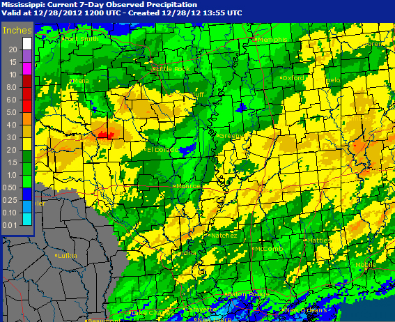
Rainfall Totals
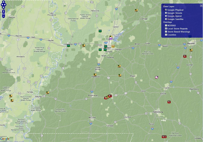
Local Storm Reports
Click on the map below for additional details.

National Storm Reports