The Great Flood of 1937 |
|
|---|---|
|
Diary of New Albany Resident Marion Groh
|
| We are deeply grateful to have received photos that comprise the Mitchell Collection. These photos of Louisville and Jeffersonville were found in a box in the home of a former resident of Bardstown during the time of the flood. Unfortunately the photos are not annotated, so if you recognize a particular location shown, we'd appreciate it if you could let us know about it. | We are also very thankful to Sherri Lane, who donated the photos shown in this collection. The photos are from an album that Sherri bought at an estate sale. | ||
|
|
 |
 |
 |
|---|---|---|
|
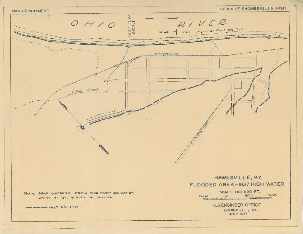
Hawesville, Kentucky Flood Map |
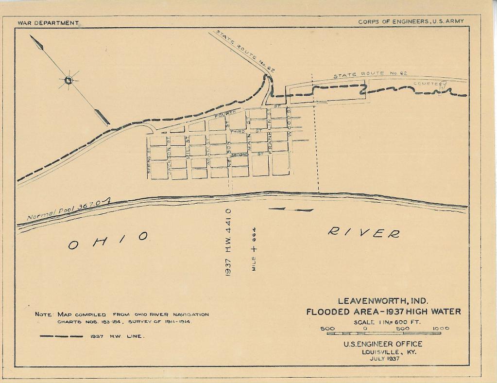
Leavenworth, Indiana flood map
|
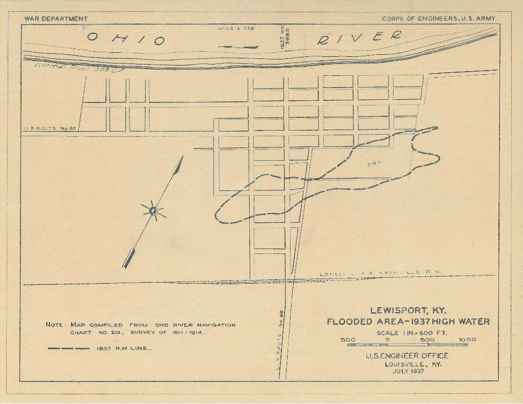
Lewisport, Kentucky flood map
|
 |
.gif) |
 |
 |
|---|---|---|---|
|
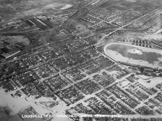
Churchill Downs on January 27,1937 |
Total Precipitation Percent of Mean for January 1937 |
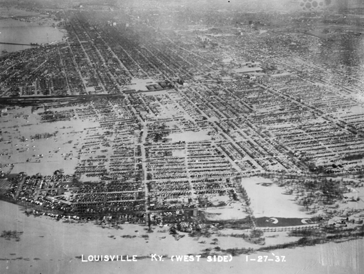
West End of Louisville, January 27, 1937 |
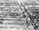
Close-Up of the West End of Louisville 1/27/37. Many thanks to Mark Fackler for identifying the location of this photo! |
 |
 |
|---|---|
|
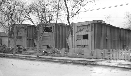
Houses flipped due to flooding |
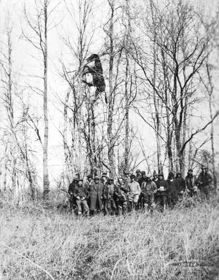
Dead horse lodged high in trees due to flood waters |
 |
 |
|---|---|
|
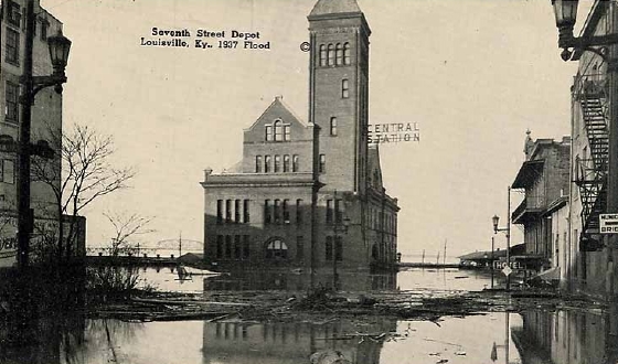
Central Station on Seventh Street |
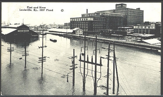
The Louisville and Nashville Railroad Freight Depot is on the left, with Belknap Hardware on the right. This was on First Street at the river. |
|
|||
|---|---|---|---|
|
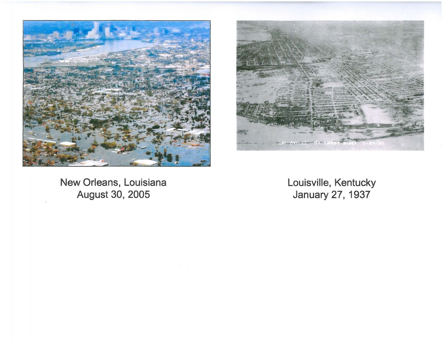
A comparison of flooding from Hurricane Katrina in New Orleans and flooding in Louisville from the great flood |
 |
|
|---|---|
 |
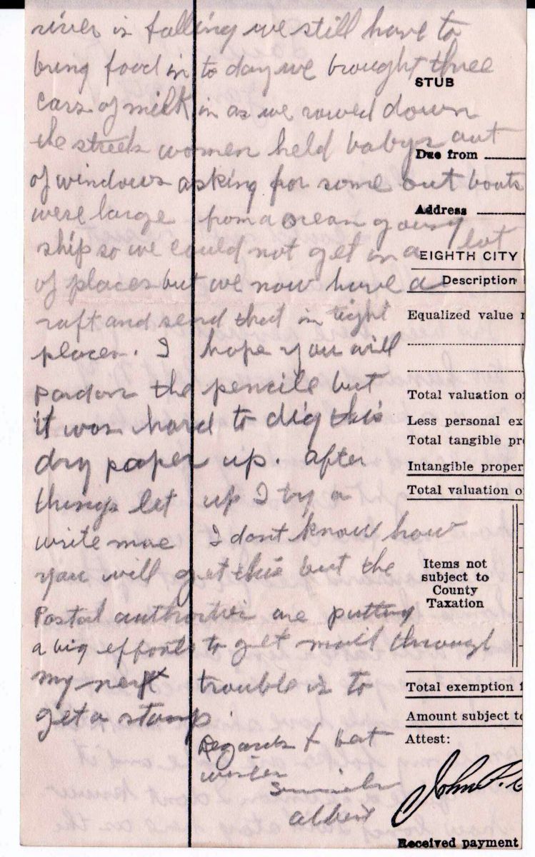 |
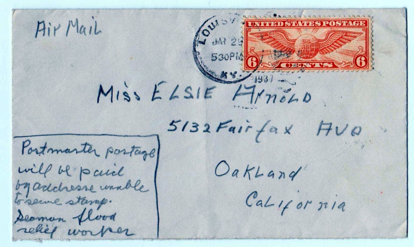
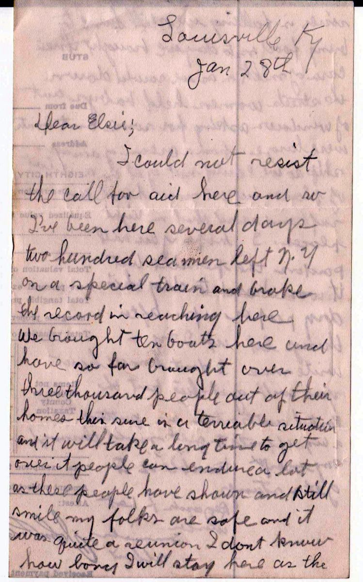
Pictured on the right are a letter and the envelope it was mailed in, from a sailor (Albert Fisher) who came to Louisville to help during the flood. It gives an amazing insight to the event, from someone who was actually there. The first page of the letter (the left-hand image below) begins, "I could not resist the call for aid here..." Click on each image for a much larger version to read the letter and its envelope. (Many thanks to Brian Plain for sending us these great finds!)
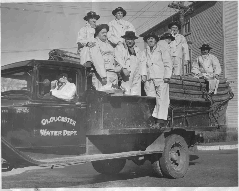
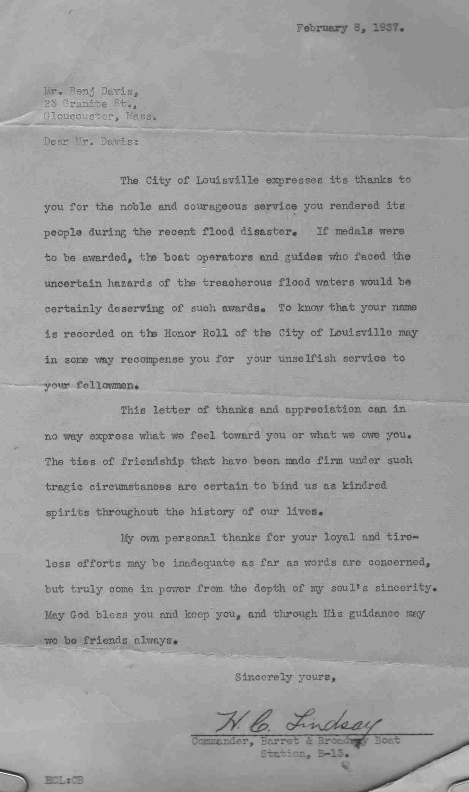
Below on the left is a photo of the Gloucester, MA Water Department. Bernett (Bennie) Davis, second from the left standing on the truck body, came all the way to Louisville to help with the flood relief efforts. On the right is a scan of the letter of appreciation Mr. Davis received from the city. Click on the images for larger versions. Thanks to Chuck Friedman for sharing these items with us.
 |
 |
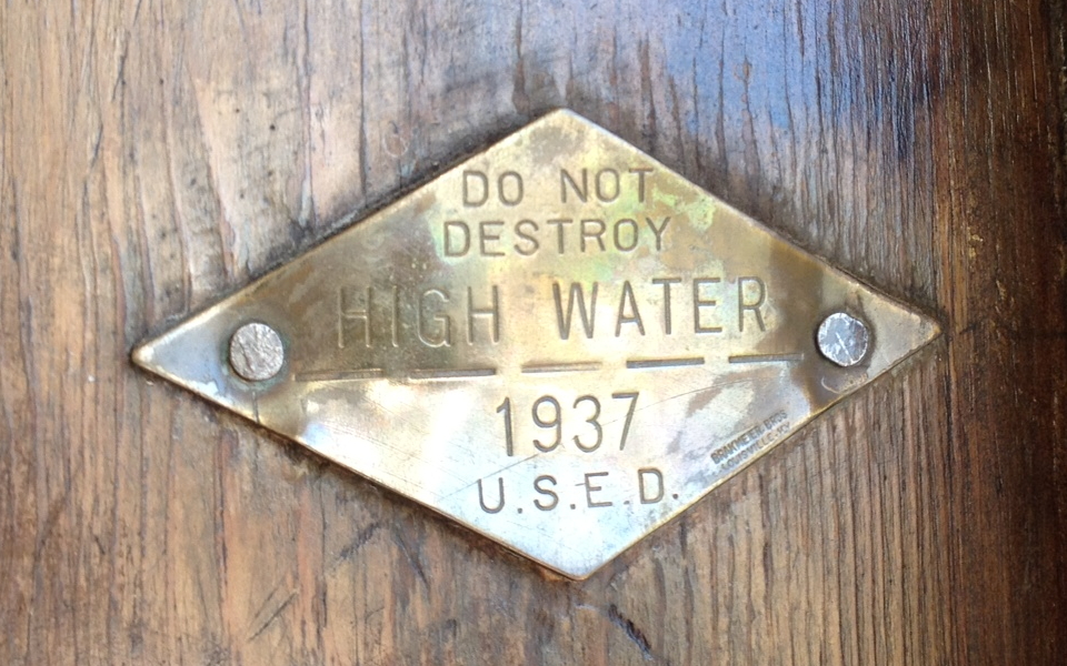
On the Huffman Mill covered bridge (about 16.6 stream miles up Anderson Creek from the Ohio River between Perry and Spencer Counties in Indiana) there is a nearly hidden tag which marks the high water line for the 1937 flood. It was placed there by the United States Engineer Department. Click on the small image below to see a larger version. Thanks to John Huffman for sharing this with us!

The following story and image appeared in the January 30, 2012 edition of the Bullitt County Historical Museum's newsletter, as written by David Strange:
Most people never notice it when they walk through the main entrance doors of the Bullitt County Courthouse.
A tiny brass marker on the inside door-frame, about six feet up.
Click on the image to see a larger version
Photo by David Strange
That little brass marker is set at the high water mark of the 1937 flood; by far the worst known flood ever to inundate the multi-state Ohio Valley region.
January 28, 2012 marked the 75th anniversary of that terrible time in our local history. On that cold January day, the Ohio River passed over its 28 foot flood stage and kept going.
In Bullitt County, as in many areas, the result was devastating. According to the state Health Department report at the time, in Bullitt County alone several thousand dairy cattle and sheep drowned. Financial loss, even in such a rural county, amounted to millions of dollars in today's money. Flooding in Shepherdsville reached fifteen feet. Two fifths of Lebanon Junction was under water. In Bardstown Junction, the water was twelve feet deep. Flood waters swept furiously across the road south of Mt. Washington at Smithville.
Entire houses were washed downstream, crashing into bridges along the way.
In western Bullitt County, I am told the old Nichols School house was flooded half way up the windows.
Set your sight on that little brass marker in the county courthouse, look out past the door, and imagine a level mark across the town at that height, and you can begin to get an idea of the shock of that flood.
Yet, just the summer before, in 1936, was one of the hottest and most drought-plagued in North American history. In one bit of dark-humor, it has been said that perhaps the flood of '37 was caused by too-earnest prayers to end the drought of '36.
And end it did. The rain started on January 9 and kept coming harder and harder. By the end of January, the Ohio River was overflowing fast and backing up the Salt River and Rolling Fork River. People kept expecting it to stop but it kept coming, faster and faster.
Suddenly farmers couldn't get livestock to high ground in time. In fact, many people barely made it to safety themselves. Some twenty-five percent of Bullitt Countians were directly affected by the flood; many moving in with friends and family and with good-Samaritan strangers. Four people drowned.
On January 21, in one story told by Minnie Maraman, she tells of going out to milk cows for what turned out to be the last time. Over the night, flood waters rose and her cows, horse, and a hog all drowned in the barn.
Many people were caught in their homes, surrounded by the rising waters. Bob Moser tells of his father going over to their barn, stripping off some of the boards, and constructing a rough boat from the material. After letting the new boat soak in the water overnight so the wood would swell and seal any leaks, the little boat worked pretty good and the family soon set to work going house-to-house rescuing neighbors. The long hours were hard work and the cold, rainy weather was miserable. People could get a little testy, but in hindsight some humorous memories were created.
On one rescue trip with the little boat, Bill (Bob Moser's brother) rescued two rather large young ladies. After they entered the boat, they would not sit still. Every time they moved, the boat took on water and Bill had to stop and bail. After the third time, Bill took one of the oars, turned around, and said, "The next time one of you moves and makes the boat dip water, I will take this oar and knock you out of my boat! Do you understand me?!"
Bill said later that he didn't think the girls breathed after that.
Hundreds of people took refuge wherever they could. The two-story Masonic Hall, then located on the southeast corner of Buckman Street and Highway 44 in Shepherdsville, was itself surrounded by water. Yet one writer from the time said that some two hundred people stayed there. Homes that were on higher ground, sometimes isolated themselves, often housed twenty and thirty people.
This created a food problem and people foraged wherever they could in order to survive.
Bob Moser tells about when the people at the Cruise family home on Chapeze Lane had used up all the food stored at the house, some of the men went down to a local distillery and got the corn meal mash that was there, using it to make "fried mush for lunch and boiled mush for dinner." One day, unnoticed by anyone, the family geese ate some of the slop that was left over from the whiskey-making process. Eventually, someone looked out and saw the geese, all dead, lying around the yard. Probably thinking it was some malady from the flood, the family put the geese in a pile until the men could return. But sometime later in the day, they heard the geese honking and saw them wobbling around the yard. The geese had just passed out from all the liquor in the slop!
And so, there was humor to be had, even in the darkest of times.
By the first Saturday in February 1937, the waters were beginning to recede much as in the days of Noah, and families made their way back to what was left of their homes and farms, and began the long recovery in a world still reeling from the Great Depression. Time moved on. Sadly, boatman/rescuer Bill Moser died just a few years later in World War Two (in Belgium), as did so many others.
Oh what a terrible time, yet what a time to remember.
To only slightly change a phrase from the Charles Dickens book A Tale of Two Cities, "It was the worst of times. It was the best of times."
Do you remember the Flood of '37? Do you have any old photos? Feel free to share them with us!


 Weather Story
 Weather Map
 Local Radar