The Great Flood of 1993
|
The size and impact of the Great Flood of 1993 was unprecedented and is considered the most costly and devastating flood to ravage the U.S. in modern history. The number of record river levels, the aerial extent, the number of persons displaced, amount of crop and property damage and its duration surpassed all earlier U.S. floods in modern times. Uniquely extreme weather and hydrologic conditions led to the flood of 1993. The stage was set in 1992 with a wet fall which resulted in above normal soil moisture and reservoir levels in the Missouri and Upper Mississippi River basins. These conditions were followed by persistent weather patterns that produced storms over the same locations. Their persistent, repetitive nature and aerial extent throughout the late spring and summer, bombarded the Upper Midwest with voluminous rainfall amounts. Some areas received more than 4 feet of rain during the period. In the St. Louis National Weather Service (NWS) forecast area, encompassing eastern Missouri and southwest Illinois, 36 forecast points rose above flood stage, and 20 river stage records were broken. The 1993 flood broke record river levels set during the 1973 Mississippi and the 1951 Missouri River floods. Over 1,000 flood warnings and statements, five times the normal, were issued to notify the public and need-to-know officials of river levels. In places like St. Louis Missouri, river levels were nearly 20 feet above flood stage and had never been this high in its 150 year history. The 52 foot St. Louis Flood wall, built to handle the volume of the 1844 flood, was able to keep the 1993 flood out with just over two feet to spare. We've put together an ArcGIS StoryMap of the event that you can access here. |
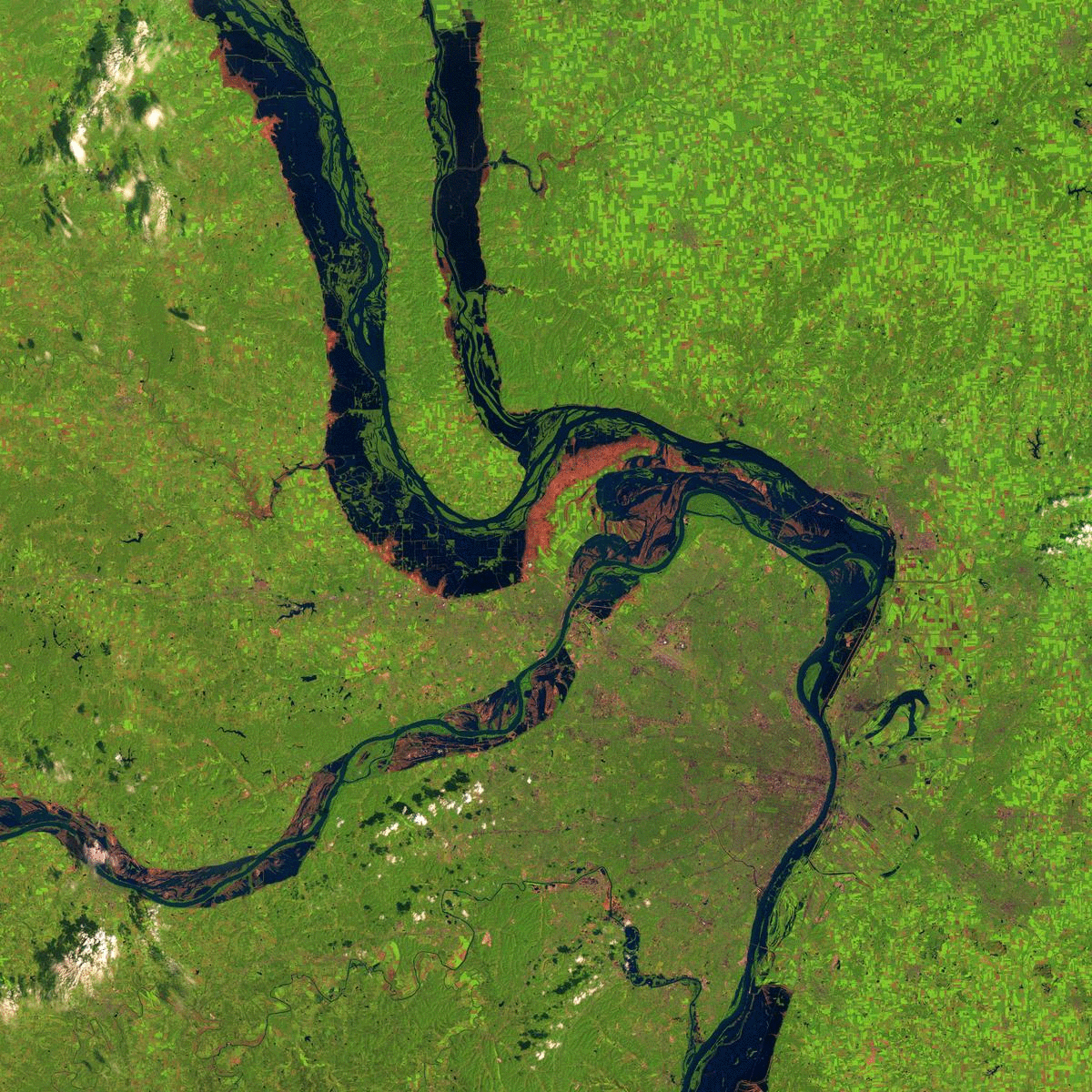 Comparing NASA Imagery from 1991 to 1993 |
Flooding
|
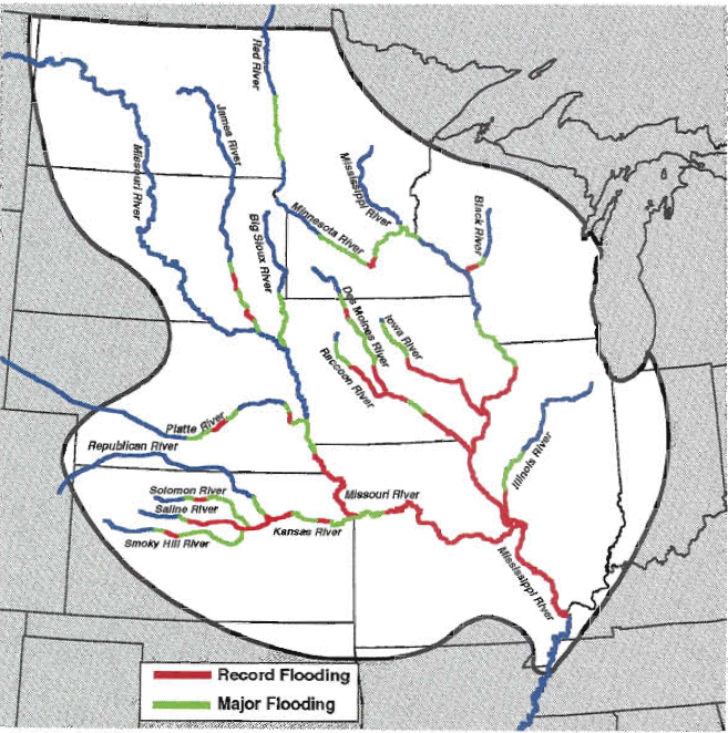
All or parts of nine states were declared Federal disaster areas: North Dakota, South Dakota, Minnesota, Wisconsin, Nebraska, Iowa, Illinois, Kansas and Missouri. within these nine states, some 500 counties received some form of Federal assistance. Flood stage (i.e., the water level at which a river goes into flood) was exceeded at approximately 500 forecast points and record flooding occurred at 95 forecast points throughout the nine-state region. Some forecast points remained above flood stage for as long as 5 straight months. St. Louis experienced river stages that exceeded the previous flood of record for more than 3 full weeks!
|
 |
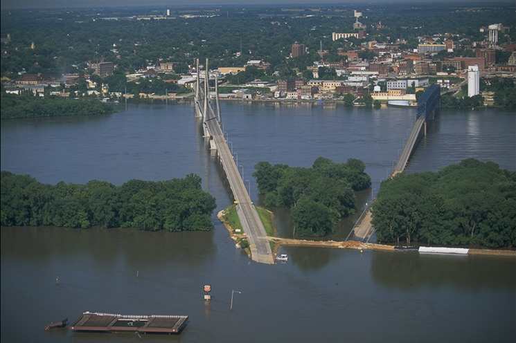
Local Flooding Photographs
 |
 |
 |
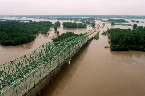 |
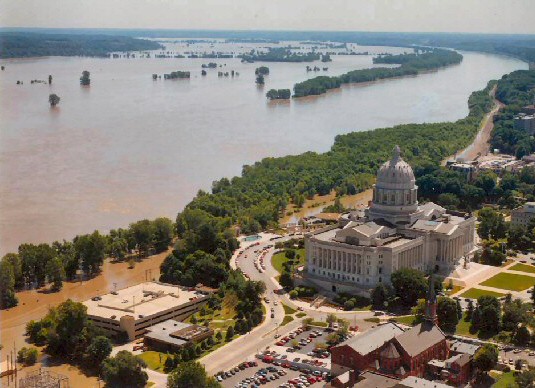
| Missouri River Flooding Jefferson City, MO |
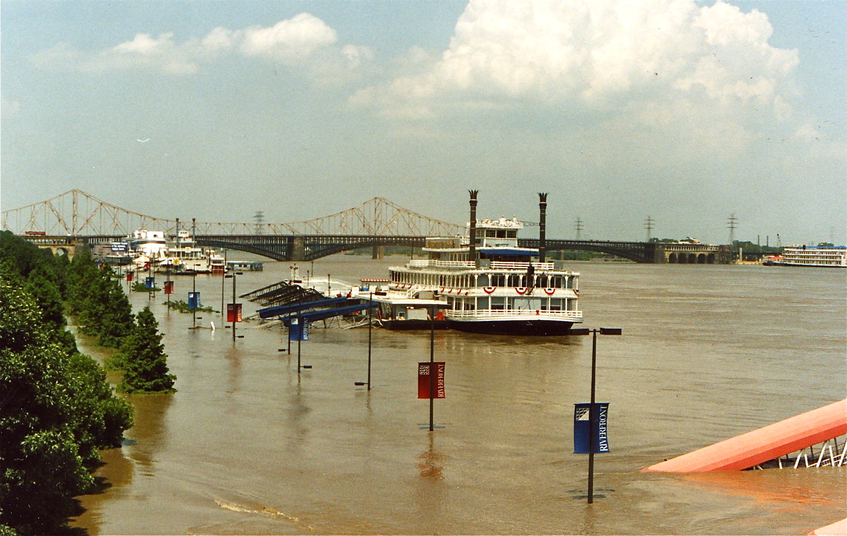
Mississippi River Flooding St. Louis, MO |
Mississippi River Flooding Quincy, Illinois |
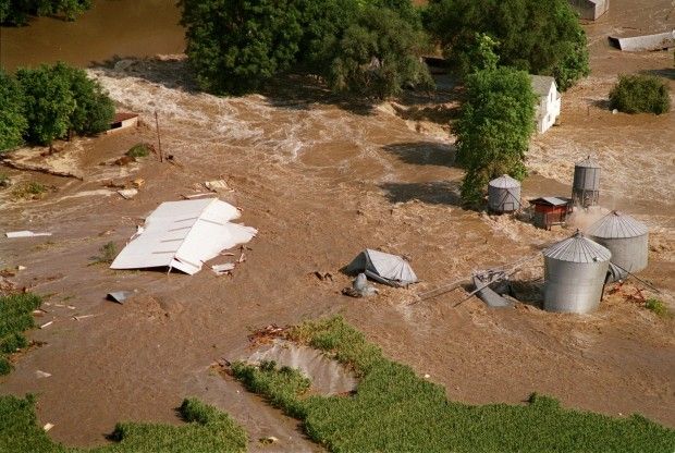
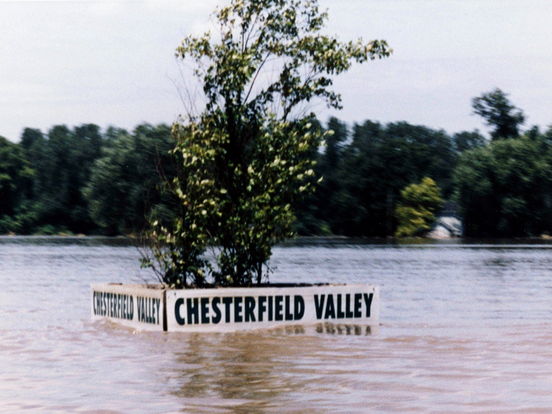
Missouri River Flooding Chesterfield, MO (Courtesy of St. Louis Post Dispatch) |
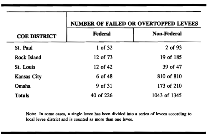
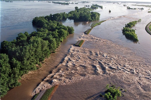
Levees
 |
 |
 |
 |
| Distribution of levee failures by Corps of Engineers Districts |
Valmeyer, Illinois Mississippi River (Courtesy of St. Louis Post Dispatch) |
Columbia, Illinois Mississippi River (Courtesy of St. Louis Post Dispatch) |
Chesterfield, MO Missouri River |
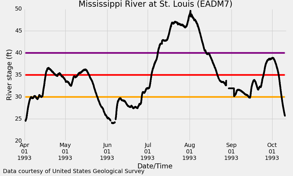
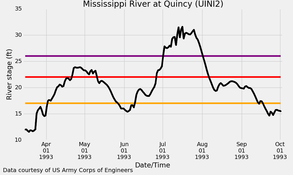
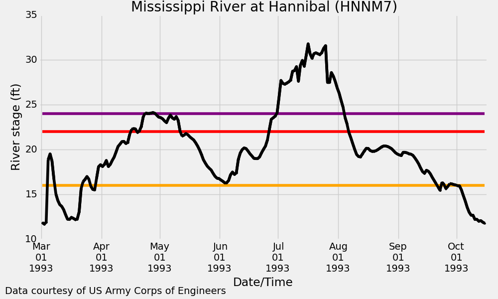
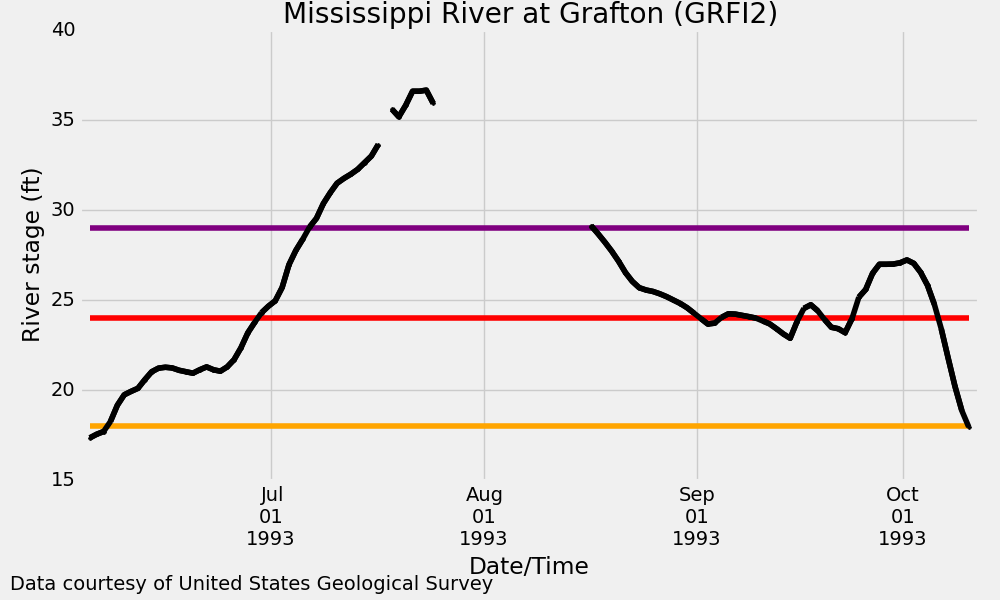
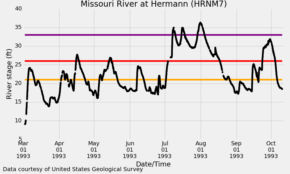
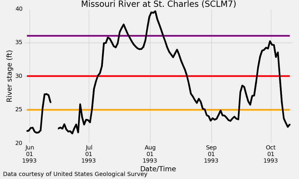
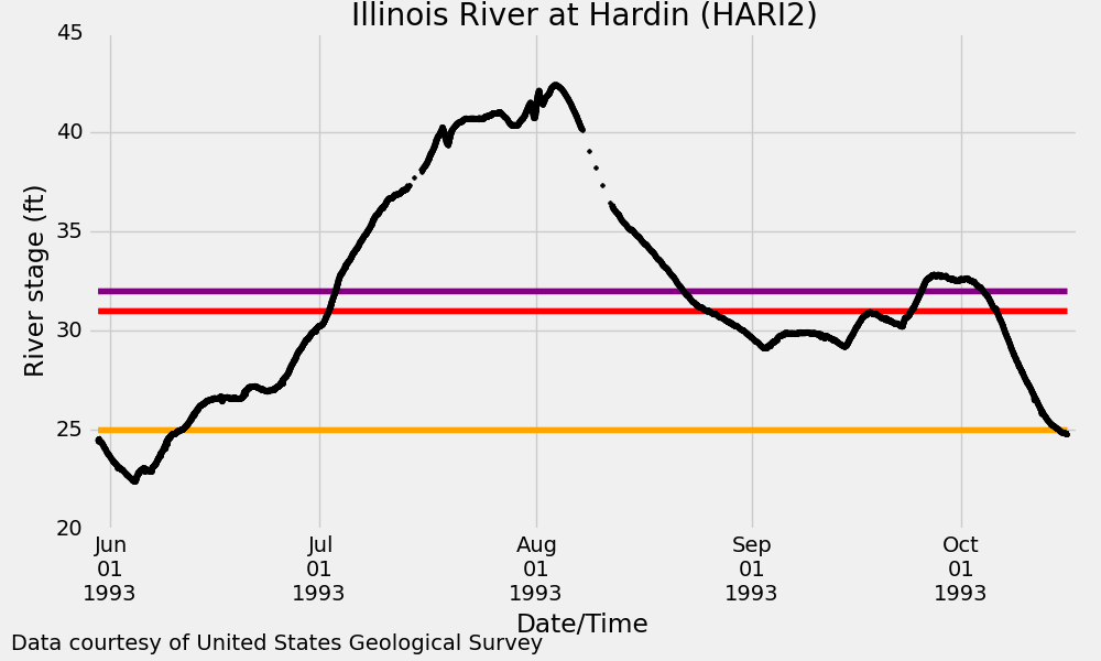
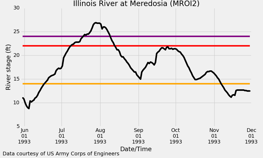
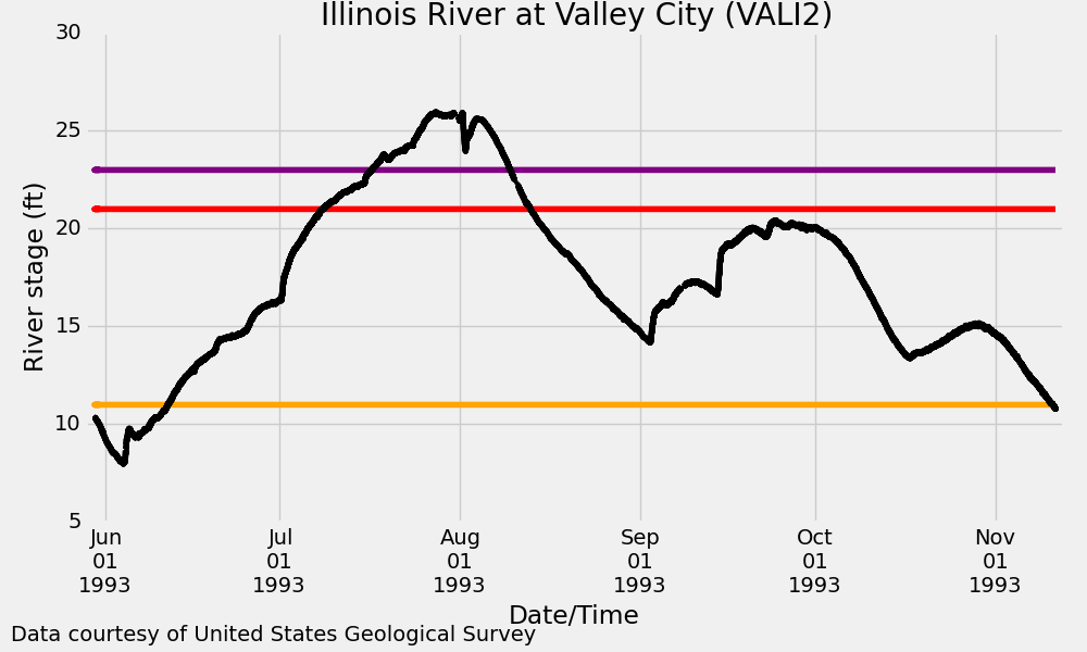
Selected Hydrographs for the Great Flood of 1993
Note: Yellow line is flood stage, red line is moderate flooding stage and purple line is major flooding stage.
 |
 |
 |
 |
| Mississippi River at St. Louis Record Crest: 49.58ft on 8/1/1993 |
Mississippi River at Quincy Record Crest: 32.12ft on 07/13/1993 |
Mississippi River at Hannibal Record Crest: 31.80ft on 07/15/1993 |
Mississippi River at Grafton Record Crest: 38.17ft on 08/01/1993 |
 |
 |
||
| Missouri River at Hermann Record Crest: 36.97ft on 07/31/1993 |
Missouri River at St. Charles Crest: 40.04ft on 08/02/1993 |
 |
 |
 |
|
| Illinois River at Hardin Record Crest: 42.40ft on 08/03/1993 |
Illinois River at Meredosia Crest: 26.96ft on 07/28/1993 |
Illinois River at Valley City Crest: 25.95ft on 07/27/1993 |
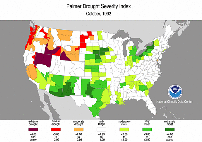
Antecedent Conditions
The flood had its origins in an extended wet period starting 9 to 10 months prior to the onset of major flooding. This wet period moistened soils to near saturation an raised many stream levels to bankfull or flood levels. This set the stage for rapid runoff and record flooding that followed excessive June and July rainfall. Soil moisture conditions can be measured by the long-term Palmer Drought Index. In August 1992, wet soil conditions began to appear in the central Great Plains, then increased dramatically by late 1992, encompassing portions of the central, eastern, and southeastern United States. By late March 1993, extremely moist conditions covered much of Kansas, South Dakota, Iowa, eastern Nebraska, southern Minnesota and Wisconsin, and northern Illinois as a result of the combination of the wet fall and spring snowmelt. Consequently, even before the onset of heavy summer rains, most of the Upper Midwest had saturated soil and well above-normal streamflows.
Meteorological Analysis
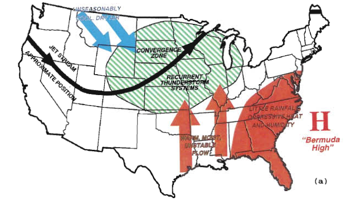
A highly anomalous and persistent atmospheric pattern of excessive rainfall occurred across much of the upper Mississippi River valley and the northern and central Great Plains during June, July and the first half of August 1993, generating devastating record flooding along the upper Mississippi and lower Missouri Rivers and many of their tributaries.
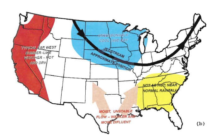
During the summer of 1993, the mean position of the jet stream had become firmly established over the northern portion of the Mississippi River basin with a southwest-northeast orientation. The quasi-stationary jet stream aloft was associated with a stationary surface front that allowed frequent and nearly continuous overrunning of the cooler air to the north by the moisture-laden air from the south. The front also served as preferred location for unusually strong and frequent cyclones, spawned by the combination of the unseasonably vigorous jet stream overhead and the relatively strong frontal boundary at the surface. Finally, by late July and August of 1993, a change in the upper air circulation pattern brought drier conditions to the Midwest as the trough shifted eastward.
An El Nino/Southern Oscillation (ENSO) episode occurred during 1992 and 1993. In 1992, similar but less intense circulation features were observed; however, no extreme flooding occurred in the United States. Nonetheless, the long-lived ENSO event probably contributed to the large-scale atmospheric features associated with the persistent 1993 Mississippi and Missouri River valley flooding.
 |
 |
| Dominant Weather Pattern June-July 1993 |
Dominant Weather Pattern August 1993 |
Rainfall
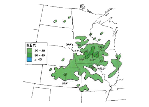
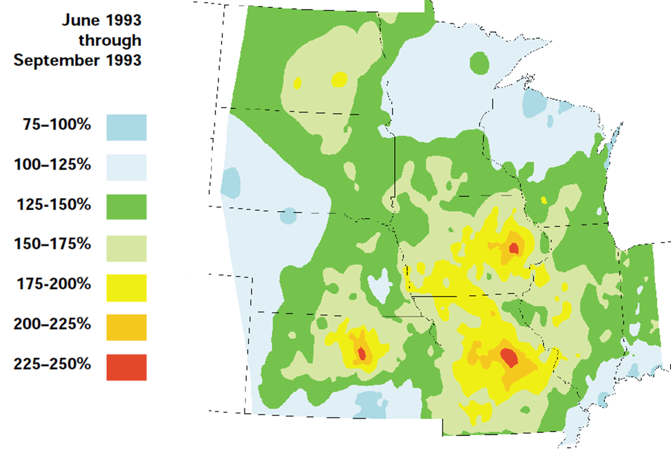
The spring and summer rainfall of 1993 is unmatched in the historical records of the central United States. During the summer (June-August 1993), rainfall totals surpassed 12 inches across the eastern Dakotas, southern Minnesota, eastern Nebraska, and most of Wisconsin, Kansas, Iowa, Missouri, Illinois, and Indiana. More than 24 inches of rain fell on central and northeastern Kansas, northern and central Missouri, most of Iowa, southern Minnesota, and southeastern Nebraska, with up to 38.4 inches in east-central Iowa. These amounts were approximately 200-350 percent of normal from the northern Plains southeastward into the central Corn Belt.Record wetness existed over 260,000 square miles. Some areas of northwestern Missouri had more than 30 inches of rain in July alone. Seasonal rainfall records were shattered in all nine states.
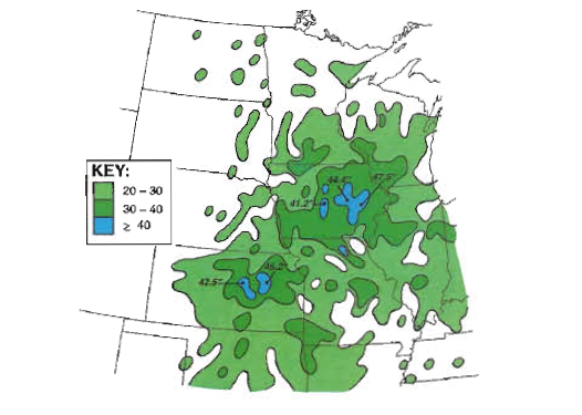
If you examine rainfall totals from the beginning of the growing season, precipitation amounts through August 31st were even more impressive with totals approaching 48 inches in east-central Iowa. This area's normal annual precipitation is around 35 inches.
 |
 |
 |
| June-August Rainfall | Growing Season Rainfall | Distribution of rainfall for the summer of 1993. (Source: Interagency Floodplain Management Review Committee 1994) |
Additional Resources
Websites
Videos
 |
Media use of NWS Web News Stories is encouraged! Please acknowledge the NWS as the source of any news information accessed from this site. |
|


 Weather Story
 Weather Map
 Local Radar