Peter Corrigan, Service Hydrologist; La Crosse WFO
The La Crosse Hydrologic Service Area (HSA), comprising 28 counties in southwest Wisconsin, southeast Minnesota and northeast Iowa, was spared the worst of the Great Flood of 1993. However, the region still suffered several major flood events, including record floods in June on the Black River in Wisconsin and record to near record floods in August in the upper Iowa and Cedar River basins in Minnesota and Iowa.
Factors leading up to the Great Flood: Fall 1992 - Spring 1993
The antecedent conditions leading up to the 1993 floods in the La Crosse HSA were similar to those in place across the entire upper Midwest. These included above normal rainfall during the fall, above normal snow depth and water content in the snowpack, higher than normal soil moisture and a wet spring. By late March the water equivalent in the snowpack ranged up to 4.4 inches in parts of southeast Minnesota (1993 National Hydrologic Outlook). The runoff from snowmelt in April produced some minor flooding but the spring crests along the upper Mississippi River do not rank in the top ten historically. Soil moisture remained
The primary meteorological factors involved in generating the tremendous floods throughout the summer of 1993 became well established by the second week of June. A large ridge of high pressure became nearly stationary over the southeastern U.S. (producing a severe drought in that area) at the same time that a strong low pressure in the upper atmosphere became nearly stationary over the northern Rockies. The high pressure pushed an abundant supply of warm, very humid air into the central U.S., while atmospheric disturbances dropping through the upper low interacted with this moisture to produce widespread convective activity. The boundary zone between these two features oscillated across the central Plains and upper Midwest throughout the summer, affecting some part of the region for over two and one-half months. In addition the near constant cloudiness and lower than normal temperatures combined to reduce evapotranspiration rates to unusually low values nearly the entire summer. Soil moisture remained well above normal throughout nearly the entire summer.
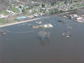 Arial view of flooding in Fountain City, WI. |
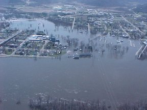 Arial view of flooding in Wabasha, MN. |
June 16-21, 1993 - Black River basin, WI: The first big flood event to affect the La Crosse HSA in mid-June as heavy rains fell across much of southern Minnesota and into western Wisconsin during this period. Rainfall was widespread and heavy across the Black River basin during the 5-day period from June 16 to 20. Over 6.4" fell at Neillsville, 4" fell at Black River Falls, and 4.79" at Galesville. No one day saw truly excessive rains, but soils were fully saturated and runoff consequently very high. Despite this, 12 counties in the La Crosse HSA were under Flash Flood Warnings at some time during this period. The runoff produced a record flood crest at Black River Falls on June 21 of 61.19 feet (Flood Stage: 47 feet) and a record discharge of 64,000 cubic feet per second (cfs). Further downstream on the Black River at Galesville, with hydrologic records dating back to 1931, the flood also produced a record stage of 16.64 feet (Flood Stage: 12 feet) and discharge of 64,000 cfs on the 21st . The USGS estimated a recurrence interval of 75 years for this discharge at Galesville. Over 100 homes in Black River Falls were flooded due to a levee failure on the river. Fifteen roads were closed due to flooding and a partial dam failure occurred at the Hatfield Dam, which impounds Lake Arbutus. Structural damage to the dam included a hole 8 feet deep and 6 feet across, as well as to damage to the tainter gates and flash boards. The USGS estimated a discharge of 80,000 cfs at this location.
June 25-July 1, 1993 - Mississippi River and major tributaries: Heavy rainfall in portions of the Upper Mississippi river basin, combined with flows from the Black River basin floods (see above) caused some near-record crests on the mainstem Mississippi river. At McGregor, IA the 22.0-foot crest on June 29 is the 3rd highest (after 1965 and 2001) and the June peak holds 6th place all time at both Guttenburg, IA and Lansing, IA.
The La Crosse HSA was spared the heaviest rainfall during the period from June 29 to July 10, although up to 7 inches was observed over extreme southwest Wisconsin and parts of northeast Iowa. Flash flood warnings were issued for Clayton county, IA on June 29-30 and for Grant county on the July 5. Some minor river flooding was observed along the Grant and Platte Rivers in Grant county as a result of the heavy rains..
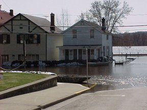 Flooding in Fountain City, WI. |
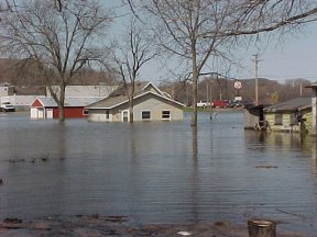 Flooding in Wabasha, MN. |
August 14-16, 1993 - Southern MN and Northern IA: Torrential rains from a mesoscale convective system fell over extreme southern Minnesota and northern Iowa in the early morning hours of the 15th, with an unofficial 10.25" reported in Adams, MN (southern Mower county). The heavy rains fell near the 500 mb ridge axis over northern Iowa as strong southwesterly flow at 850 mb produced high theta-e advection over the heavy rain area. Precipitable water was roughly 150% of normal over the area and several weak short waves traversed the region helping to destabilize the atmosphere. Flash flood warnings were issued for the four northeastern Iowa counties of Howard, Chickasaw, Winneshiek and Mitchell early on the 15th. River flooding was severe on the Cedar River in Austin with the second highest crest to that date (19.43 feet, less than one foot below the 1978 peak). The basin-wide runoff into the Cedar caused the river at Charles City, IA to reach a record 21.44 feet (Flood Stage: 12 feet) on the 16th , a record since eclipsed by the July, 1999 flood. The Upper Iowa River basin also received heavy rains, with 6.1" of rain reported at Spillville, IA. Record flooding (19.0 feet) occurred on the 17th at Spillville, exceeding the June, 1947 record and Decorah had its third highest crest to that date. Downstream on the Upper Iowa River, the USGS gage near Dorchester had it's 2nd highest stage (20.0 feet - Flood Stage:14 feet) and discharge (22,000 cfs) since records began in 1941.


 Weather Story
 Weather Map
 Local Radar