National Weather Service United States Department of Commerce
Click a location below for detailed forecast.

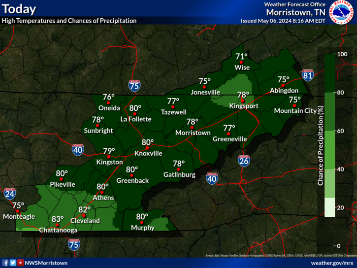
Last Map Update: Fri, Apr. 26, 2024 at 6:08:16 am EDT

National Weather Service Louisville, KYNational Weather Service Jackson, KYNational Weather Service Charleston, WV
National Weather Service Nashville, TNZoom
Out

National Weather Service Blacksburg, VA
National Weather Service Huntsville, ALNational Weather Service Peachtree City, GANational Weather Service Greenville-Spartanburg, SC


A gradual warming trend is expected into the weekend with a slight chance of light rain today. Breezy winds are possible tonight through Saturday, especially in the higher elevations. Temperatures will be above normal through the middle of next week.
A gradual warming trend is expected into the weekend with a slight chance for rain on Friday. Breezy winds are possible Friday through Saturday, especially in the higher elevations. Showers and thunderstorms are likely early next week.

 Current Weather Observations...
Location Time
(EDT)
Weather Vsby.
(SM)
Temp.
(ºF)
Dewpt.
(ºF)
Hum.
(%)
Wind
(mph)
Wind Chill / Heat Index
(ºF)
Pres.
(in)
Abingdon VA05:55Clear10534369E 9-30.20
Andrews-Murphy NC05:49Overcast10504685CALM-30.16
Chattanooga TN05:53Overcast10635062E 3-30.10
Crossville TN04:53Light Rain10544366CALM-30.13
Dalton GA05:55Overcast10585799CALM-30.09
Knoxville TN (McGhee-Tyson)05:53Overcast10554877CALM-30.11
Middlesboro KY05:55Clear10494483CALM-30.15
Monroe Cnty TN05:55Overcast10555187CALM-30.12
Morristown TN05:55Overcast10553750CALM-30.11
Oak Ridge TN05:53Overcast10584459CALM-30.13
Tazewell Cnty VA05:55Clear10524885ESE 14G21-30.20
Tri-Cities TN05:53Mostly Cloudy10464285CALM-30.17
Wise VA05:55Clear10503557SE 6-30.19
Greeneville, TN05:55Mostly Cloudy10594151E 6-30.13


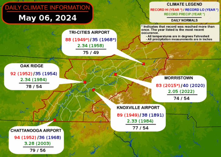
Local Weather History For April 26th...
In 2012 frontal boundary triggered storms in the morning and
afternoon with wind damage and 2" hail.


Briefing Hydrology Past Weather Events Graphical Hazardous Weather Outlook for East Tennessee East Tennessee Observations
Decision Support Hydrology Past Weather Events GHWO Observations Gridded Forecast
Daily Climate for Middle Tennessee Local East Tennessee Climate Tornado Database Tropical Weather Information NOAA Weather Radio
IDSS Point Forecasts Daily Climate Local Climate Tornado Database Tropical Weather Radio
Daily Climate for Middle Tennessee Probabilistic Data for East Tennessee Virtual Tour of the NWS Morristown Office Skywarn Spotter Training for East Tennessee  
Being Prepared Estar Perparado Probabilistic Virtual Tour Spotter Training