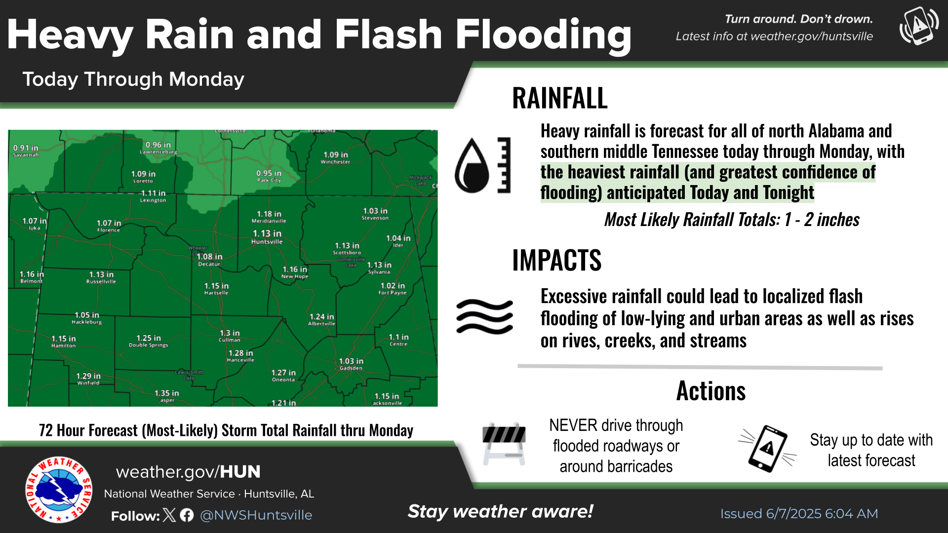
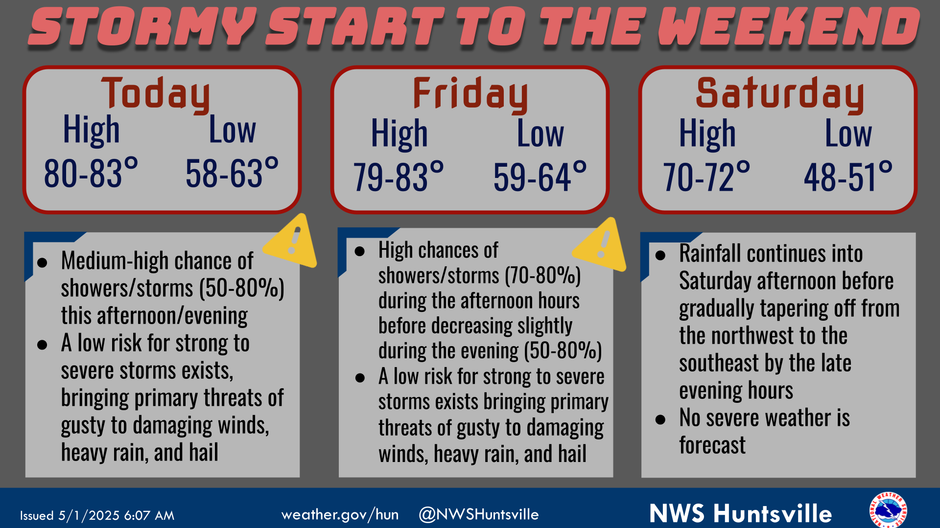
National Weather Service United States Department of Commerce
Click a location below for detailed forecast.

Last Map Update: Sat, Mar 15, 2025 at 12:32:40 am CDT

Multiple rounds of strong to severe storms are forecast this weekend. For tonight, storms may bring damaging winds up to 60mph, a tornado or two, and large hail (up to 1" in diameter). Have multiple ways to get warnings, including one that will wake you up before going to sleep tonight!
Saturday, the severe threat increases with multiple rounds of severe thunderstorms forecast throughout the day, capable of producing damaging winds (70mph+), large hail (1+ inch in diameter), flash flooding, and several tornadoes (some strong EF2+). Have a plan in place if a warning is issued & have multiple ways to get warnings!
Several rounds of heavy rainfall are also forecast Friday through Saturday night, with totals 3-5" with locally higher amounts. This could lead to flash flooding and rises on rivers, creeks, and streams. Turn Around, Don't Drown if you encounter flooded roads!
A wind advisory will be in effect for non thunderstorm winds from 7 AM Saturday through 1 AM Sunday. This is for gusts of 30-40 MPH with higher gusts possible in elevated areas.
Low temperatures and precipitation chances for tonight.
High temperatures and precipitation chances for tomorrow.
This graphic contains daily climate data (climate normals and records) for today for the sites listed. The legend is in the upper left portion of the image. The current normals period is 1991-2020.


Location Sky/Weather Temp Dewpt RH Wind Baro Remarks
Huntsville


Muscle Shoals


Decatur


Meridianville


Vinemont


Albertville


Scottsboro


Fort Payne


Note: "N/A" or "MISG" will be displayed if values are not available. In the LOCATION column, click on links for a list of recent observations at sites of interest. In the WIND column, VRB is "variable" and G is "gust". Wind speeds are in MPH. In the BARO (pressure) column, values are in inches. In the REMARKS column, HX is "heat index", WCI is "wind chill index", and VSB is "visibility" (if shown).
Text Product Selector (Selected product opens in a new window)
SITREP GRAPHICAL HWO DISCUSSION FIRE WX AVIATION WX HYDROLOGY
 
AIR QUALITY GRIDDED FORECAST FORECAST (HR) CLIMATE CLIMATE GRAPHS OBSERVATIONS
 
SATELLITE WX RADIOS   STORM SPOTTER TRAINING   PAST EVENTS GIS TORNADO HISTORY
Daily Climate for Middle Tennessee
EDUCATION BEING PREPARED ESTAR PREPARANDO