Cold temperatures will continue across much of the eastern U.S. into today. Heavy lake effect snow continues into today east of Lakes Erie and Ontario. Two Pacific cold fronts will cross the Pacific Northwest early this week followed by another atmospheric river. Heavy rain and gusty winds are expected through midweek, with the potential for renewed urban and river flooding. Read More >
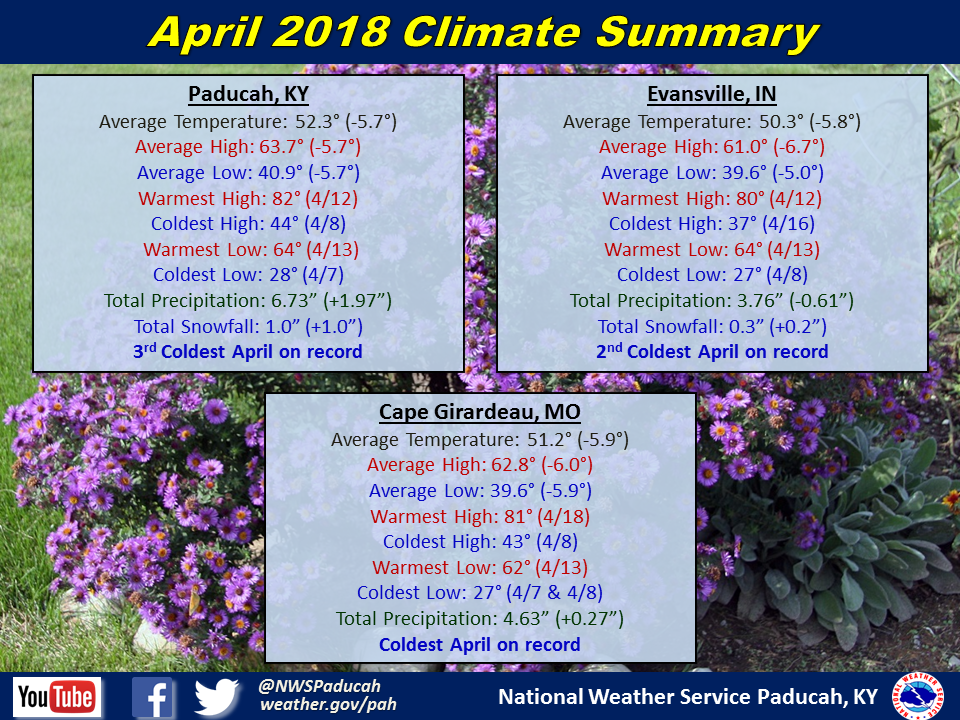
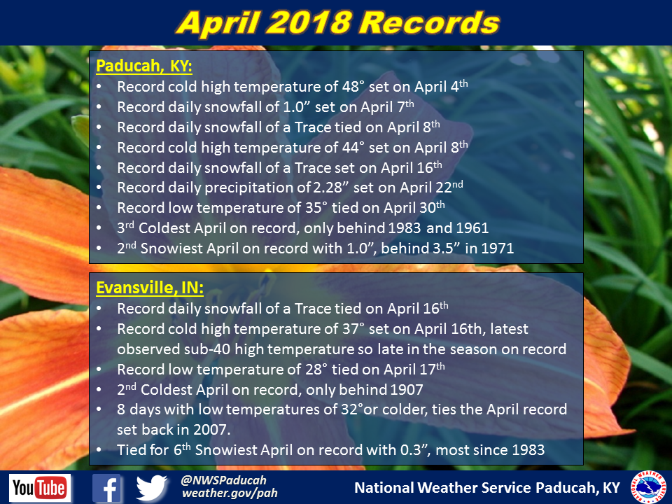
April 2018 Climate Review: Temperatures were well below normal, ranging from 5 to 7 degrees below normal across the region. All 3 official climate stations registered one of their top 3 coldest April’s on record. The entire region hadn’t experienced an April this cold in 35 years (1983). In fact, some locations observed their coldest April on record, including Cape Girardeau, MO where records date back to 1961. We weren’t alone, as the entire central U.S. experienced well below normal temperatures for April. We basically just had a continuation of typical March-like weather and skipped April this year. There were only 5 days that observed an average daily temperature above normal in Paducah. We actually did manage to hit 80 degrees twice though, on April 12th and 18th.
As for precipitation, it was wetter than normal across the Jackson Purchase area of western Kentucky into much of southern Illinois along and south of Route 13. It was also somewhat wetter than normal across much of southeast Missouri. Drier than normal conditions were observed across the Ozark Foothills of Missouri, up along the I-64 corridor in Illinois, and across much of southwest Indiana. Rare April snow greeted the region as well, with many locations experiencing their first April measurable snowfall since 1983! The event on April 7th brought amounts ranging from a half an inch up to near 2 inches across a large swath of the area. Another disturbance produced some flurries and light snow showers across the region on April 16th, but with no accumulation. In Paducah, KY this was the 4th latest snow on record, behind April 17, 2001 (Trace), April 18, 1953 (Trace), and April 18, 1983 (0.5”).
April is typically an active severe weather month in our region, but this year it was unusually quiet, besides for one big event on April 3rd. This event produced 11 tornadoes in our region along with many reports of damaging winds and hail up to baseball size. Heavy rain occurred from the night of April 22nd into the day on April 24th, resulting in amounts of 3 to 5 inches across much of the Jackson Purchase area of west Kentucky into far southern Illinois. Since the rain fell over a longer period of time, we didn’t have much in the way of flooding issues with this event.
| April 2018 Review: Precipitation and Temperature Maps (Click on image to enlarge) |
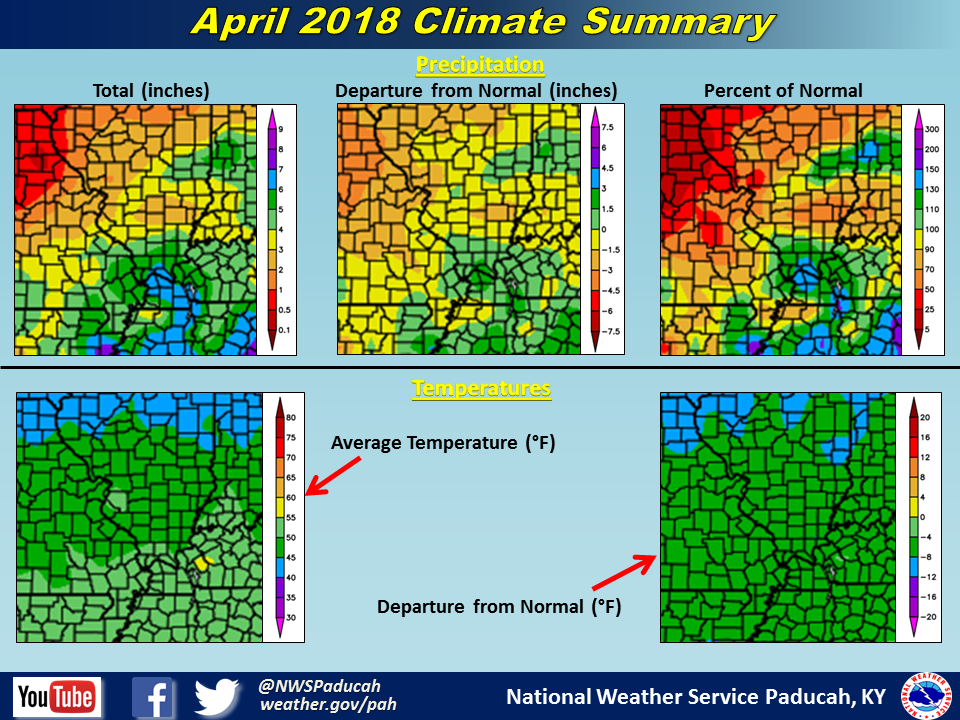 |
| Climate Maps are from the Northeast Regional Climate Center |
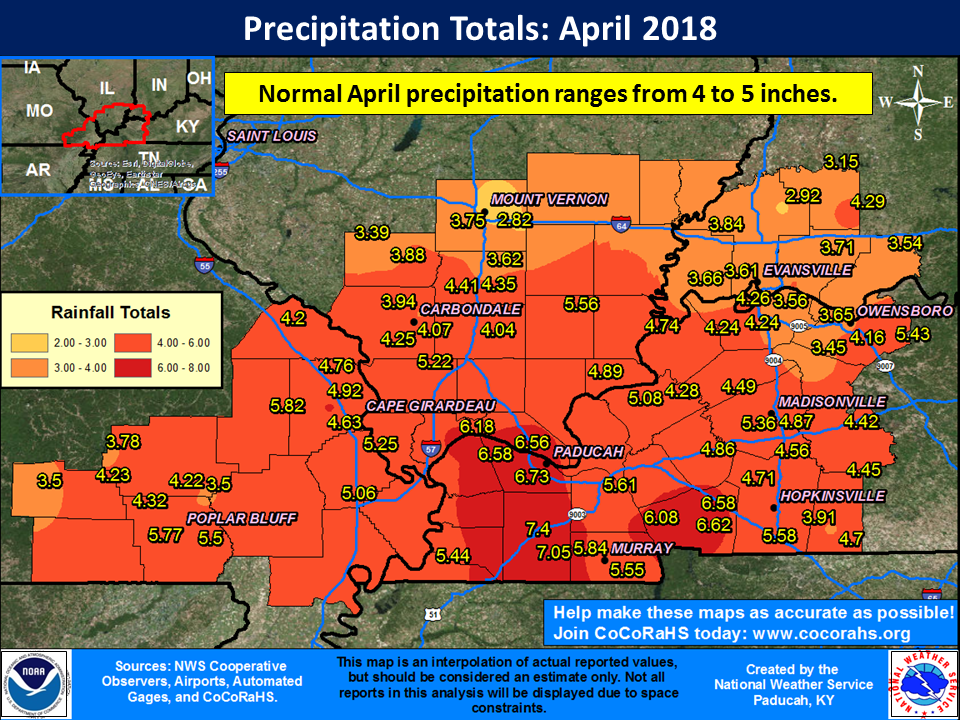
The graphic below is an interpolated rainfall map using actual observations. Please note that there are likely discrepancies in between observations, since the values are estimated based on nearest reports.
 |