| Y2K Rewind: A Review of Weather in 2000 |
The last year of the millennium was marked by extremes in weather both locally and nationwide. In February, a devastating tornado outbreak killed 19 people in Southwest Georgia. Here in Tallahassee, temperatures were above normal for most of the year with very hot conditions during spring and summer. This was followed by a sharp turn to colder than normal conditions beginning in September with very chilly conditions in November and December. The transition month of September was also one of the few very wet months of the year, aided in large part by the impact of two tropical storms, Gordon and Helene. The remainder of the year was very dry and 2000 went into the books as the third consecutive year of drought in Tallahassee. Following are a few of the highlights in weather that occurred in the NWS Tallahassee County Warning & Forecast Area.
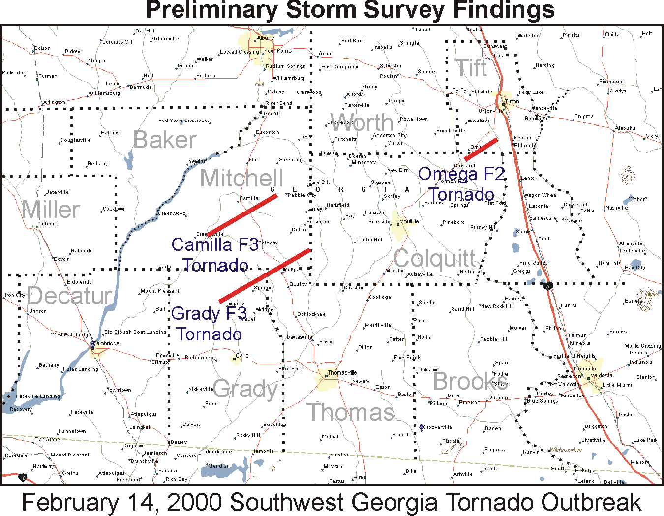
Southwest Georgia Tornado Outbreak of 13-14 February 2000
Beginning Sunday evening, 13 February 2000, and continuing into the early morning hours of Monday, 14 February, the NWS office in Tallahassee issued 52 warnings. These included 25 tornado, 24 severe thunderstorm, and 3 special marine warnings. During this time, warnings were issued for three deadly tornadoes, which caused the loss of 19 lives in Southwest Georgia, an event unequaled in this part of the state in nearly 50 years. Figure 1 shows where the fatal tornadoes occurred in Mitchell, Grady and Colquitt Counties in southwest Georgia. Injuries were reported in two other counties. See our web page on the outbreak to learn more about this tragic event. While this was certainly the most significant severe weather episode of the year, other days with notable severe weather occurred on January 24; March 11 & 16; April 24; July 12, 20-21 & 22-23; August 9-10, 18 & 25; September 22; November 9 and December 16.
Mild Winter - Hot Spring and Summer
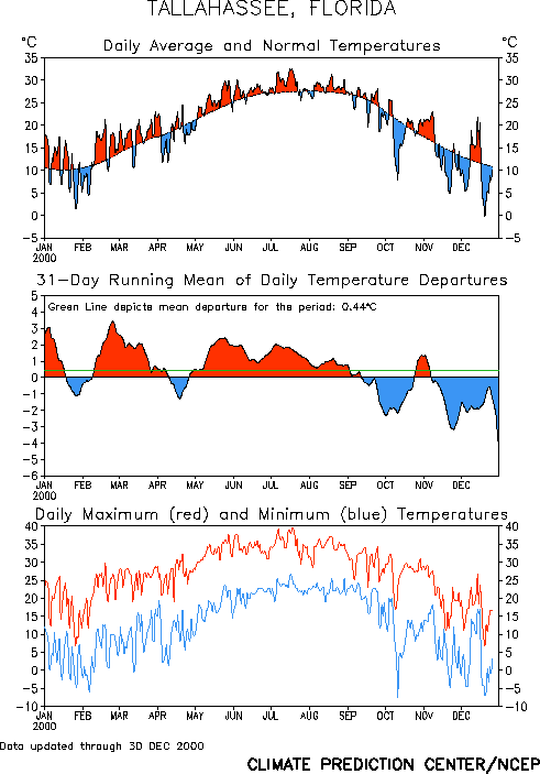
As can be seen in Figure 2, the winter and spring months were warmer than normal with only brief cool periods. The last significant freeze of the season occurred during the first week in February. Of the first eight months of the year, only April was below normal. During summer, the heat was unrelenting, with only a few days all season long averaging cooler than normal. The temperature reached or exceeded 100 degrees in Tallahassee eleven times last summer. The first occurrence was on May 28, the earliest such occurrence in the season since observations began at the airport location back in 1961. July was particularly brutal and several all-time records were tied or broken. The mercury reached the century mark eight times that month, including six days in a row from the 15th to the 20th. The temperature reached 103 degrees on three occasions in July, which ties for the warmest temperature ever recorded at the airport location. On July 18, the mean temperature for the day was 91, which tied for the warmest day of all time. The lowest temperature recorded on the 17th was 80 degrees. This marks the first time on record that the temperature never fell below 80 during an entire calendar day in Tallahassee. In August, the mercury never reached 100, but did soar into the upper 90s seven times, including three consecutive days in the middle of the month when the daily maximum was 99.
Cold Autumn and Early Winter
A sharp turn to cooler than normal conditions began in September with temperatures averaging below normal during the last four months of the year. An early season cold snap occurred during the second week of October. Daytime maximum temperatures were in the lower 60s on the ninth and tenth, below normal even for January. The first freeze of the season occurred on November 21, a bit later than usual. However, the next morning saw a hard freeze across the region with a marginal freeze the day after that, Thanksgiving Day. In December, temperatures dipped below the freezing mark on nearly half the days with hard freezes occurring nine times. The coldest temperature of the year 2000 occurred on the last day of the year when the mercury dipped to 18 degrees on December 31, the coldest December temperature in Tallahassee since 1989. The last time it got colder than 18 degrees was back in February 1996. The average temperature for December 2000 was 48.9 degrees, the coldest such month in Tallahassee in eleven years. On December 19, there was even a trace of snow observed, the first such occurrence since January 1996. The cold weather continued into the first part of 2001 with hard freezes occurring on ten of the first eleven days of January. In total, there were 29 freezes in Tallahassee from November 21 through January 11, including an incredible ten days in a row from December 29 through January 7.
Another Year of Drought
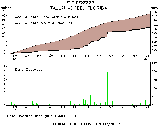
The local drought that began in the spring of 1998 continued for a third consecutive year during 2000. As can be seen in Figure 3, the rainfall deficit grew steadily during the year, peaking on July 22 at over 26 inches. May was particularly dry with only one day of measurable rain totaling just 0.16 inches. After regaining some ground in September, the autumn months were very dry and the deficit rose back above 22 inches by year's end. During one of the driest stretches, only one day of measurable rain occurred between September 27 and November 8. The annual rainfall total in Tallahassee was just 44.53 inches, which makes 2000 the driest year since 1955.
Tropical Storms Gordon and Helene
The only two named tropical cyclones to make landfall in the United States during the 2000 season came ashore along the Gulf Coast of North Florida in September. Tropical Storm Gordon made landfall near Cedar Key, FL, on the evening of September 17. Gordon spawned a few tornadoes across central and south Florida and caused some tidal flooding along the west coast of the peninsula. After moving inland, the remnants of the storm caused some flooding in a few southeastern states. Fortunately, the Florida Big Bend was on the weak left side of the storm at landfall and there were minimal impacts. Only about two thirds of an inch of rain fell in Tallahassee and the peak wind gust that evening was just 24 mph. Additional information on Tropical Storm Gordon can be found here.
Less than five days later, Tropical Storm Helene made landfall near Fort Walton Beach, FL, during the early morning hours of September 22. Much of the Big Bend and southwest Georgia were on the stronger right side of this storm at landfall. Even though Helene was only a minimal tropical storm as it crossed the coast, with peak sustained winds of only 40 mph, winds did gust to tropical storm force in Tallahassee with a peak gust of 35 mph. The highest wind gust in the area was 45 mph at Cape San Blas. Heavy surf resulted in some minor beach erosion. The most significant impact from Helene was the flooding tropical rains. Nearly eight inches of rain fell in Tallahassee with up to ten inches closer to the coast in places like Apalachicola. Flooding was extensive in Franklin, Wakulla and Leon Counties. These and several other counties were declared federal disaster areas. Numerous homes along the Sopchoppy River were flooded as the river crested at a record 34.9 feet. Nearly 70 streets in Tallahassee were impassable due to high water and 5,000 homes lost power in Leon and Wakulla Counties. Helene also spawned numerous tornadoes in the Big Bend area with an F1 tornado touching down along Highway 65 in Franklin County and a waterspout coming ashore at Alligator Point. Fortunately, there were no local fatalities associated with Helene, but a tornado did cause one fatality in South Carolina as the remnants of Helene moved northeast. Additional information on Tropical Storm Helene can be found here.
National Weather Headlines
Many of the same weather conditions made headlines around the nation. Figure 4 (below) indicates that much of the southern and western U.S. suffered from drought last year. Statewide, Florida experienced its driest year on record in 2000 with the Dixie states as a whole seeing the driest May through October on record. At the peak of the drought, in August, 36% of the nation was suffering from severe or extreme drought as shown in Figure 5. In the West, the dry weather resulted in one of the worst wildfire seasons in 50 years. The year was also on the warm side. The winter of 1999-2000 was the warmest on record in the U.S. The summer that followed was a scorcher with many areas from Texas across the Gulf states seeing peak summer temperatures much higher than recent years. In contrast, much of the Northeast saw much cooler and wetter conditions than normal during the summer. July 2000 was the coolest on record in the Northeast with some cities never reaching the 90-degree mark that month.
After the mildest U.S. winter on record the previous season, winter 2000-2001 could not have started on a more frigid note. In fact, when taken together, November and December 2000 were the coldest two such months on record in the U.S. as can be seen in Figure 6. Notoriously snowy Buffalo, NY, recorded the snowiest October through December period on record with a record 45 inches falling in November alone. Nearby Syracuse, NY, was even snowier with a new December snowfall record established at 70.3 inches. Both cities exceeded 100 inches of snowfall for the season during the first week of January, a record for both locations. Other parts of the country also dealt with abnormally snowy conditions. At Midway Airport in Chicago, a new 24-hour snowfall record was set on December 11 when 14.5 inches fell, breaking a 31 year old record. Monthly snowfall records were also set in Marquette, MI, Milwaukee, WI, Waterloo, IA, and Amarillo, TX.

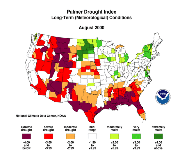
Figure 5. Drought conditions across the U.S. in August 2000.
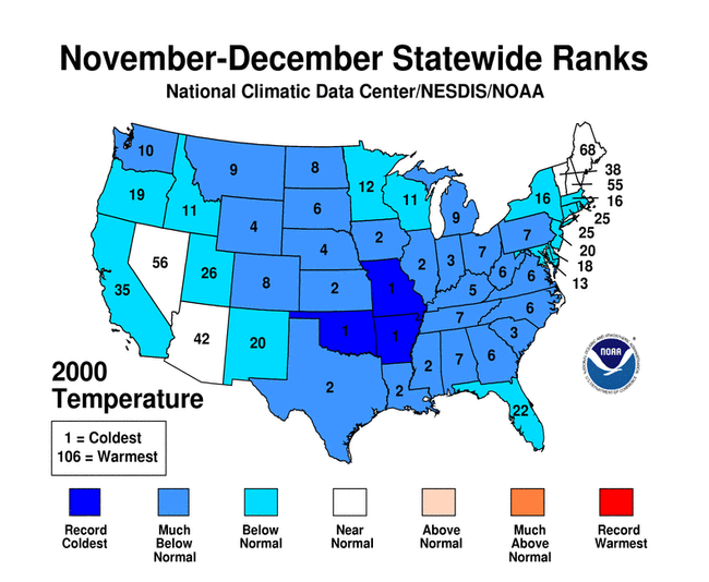
Figure 6. Rank of cold November-December 2000 temperatures compared with previous years.


 Follow us on YouTube