NWS Birmingham, Alabama
Weather Forecast Office
|
Weather Review - June 28, 2009 |
|
|
|
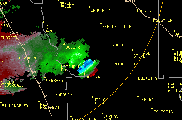
Above is an animation of a storm that formed over southwest Coosa County on June 28, 2009. At the beginning of the loop, an outflow boundary from an earlier storm (the light blue line of reflectivities in a NW-SE orientation) is moving to the southwest. Once the outflow boundary meets with the already forming storm just to the east of Mitchell Dam, the storm intensifies warranting the issuance of a Severe Thunderstorm Warning. Below is a still image of the above storm at its most intense. Depicted here is a radar phenomenon known as Storm Top Divergence. Storm Top Divergence is an indicator of how strong a storm has become. Once the updraft in a thunderstorm reaches the tropopause, it can no longer go any higher in elevation. In turn, it spreads out at the top of the thunderstorm into what is called the anvil. The intensity of this spreading is measurable on radar using velocity data. Measured by adding the intensity of the inbound velocities and the outbound velocities, most studies have concluded that 75 knots of Storm Top Divergence is enough to sustain hail growth large enough to meet severe criteria (3/4 inch). This example of Storm Top Divergence illustrates 124 knots of divergence at 54,000 feet. Though no hail or wind damage was reported with this storm (very rural area), this storm was by far the strongest of the day in central Alabama. |
|
|
Current Hazards
National Outlooks
Tropical
Local Storm Reports
Public Information Statement
Graphical Hazardous Weather Outlook
Current Conditions
Regional Weather Roundup
Rivers and Lakes
Drought Monitor
Forecasts
Air Quality
Fire Weather
Aviation Weather
Graphical Forecasts
Forecast Discussion
Climate and Past Weather
Past Events
Storm Data
Tornado Database
Daily Rainfall Plots
Tropical Cyclone Reports
Warnings and Other Products
Tornado Warnings
Severe Thunderstorm Warnings
Flash Flood Warnings
Winter Weather Warnings
Special Weather Statements
Non-Precipitation Warnings
Flood/River Flood Warnings
Productos en Español
Conciencia y Preparación
Previsión de 7 Días
Weather Safety
NOAA Weather Radio
Severe Weather Preparedness
Severe Safety Rules
Tornado Safety Rules
Severe Safety w/ ASL
Awareness Weeks
Severe Weather
Hurricane Preparedness
Summer Safety Campaign
Winter Weather
US Dept of Commerce
National Oceanic and Atmospheric Administration
National Weather Service
NWS Birmingham, Alabama
465 Weathervane Road
Calera, AL 35040
205-664-3010
Comments? Questions? Please Contact Us.