Thunderstorms with severe wind gusts and hail will be possible today across parts of the central Plains, and from the Missouri Valley into the upper Mississippi Valley. Heavy rain associated with the thunderstorms may also produce flash/urban flooding. Critical fire weather conditions expected in the Great Basin and interior Northwest. Dangerous heat continues across the Southwest and Southeast. Read More >
Overview
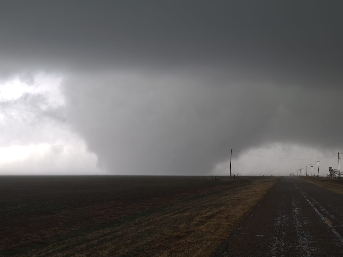
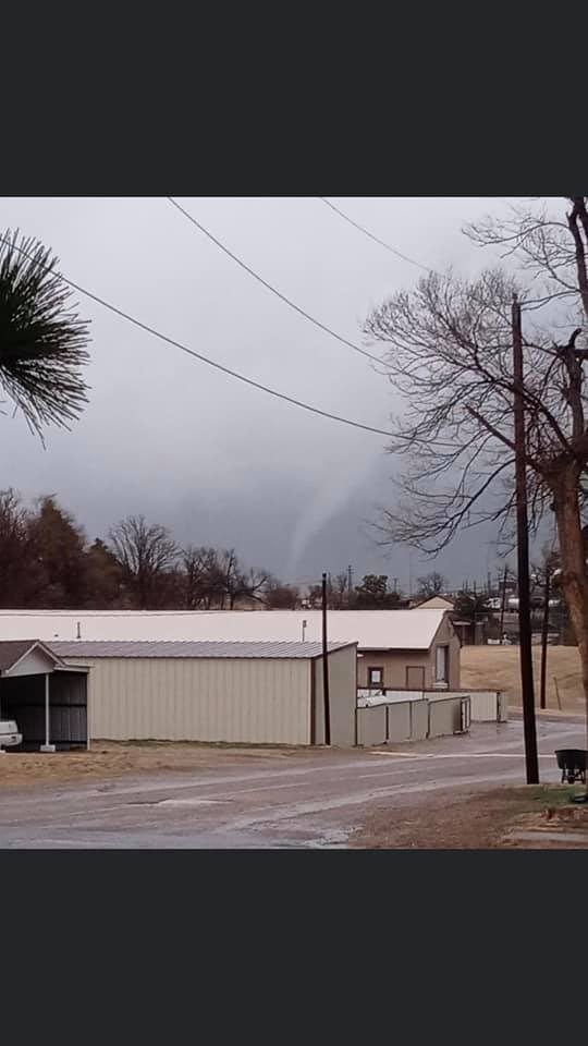
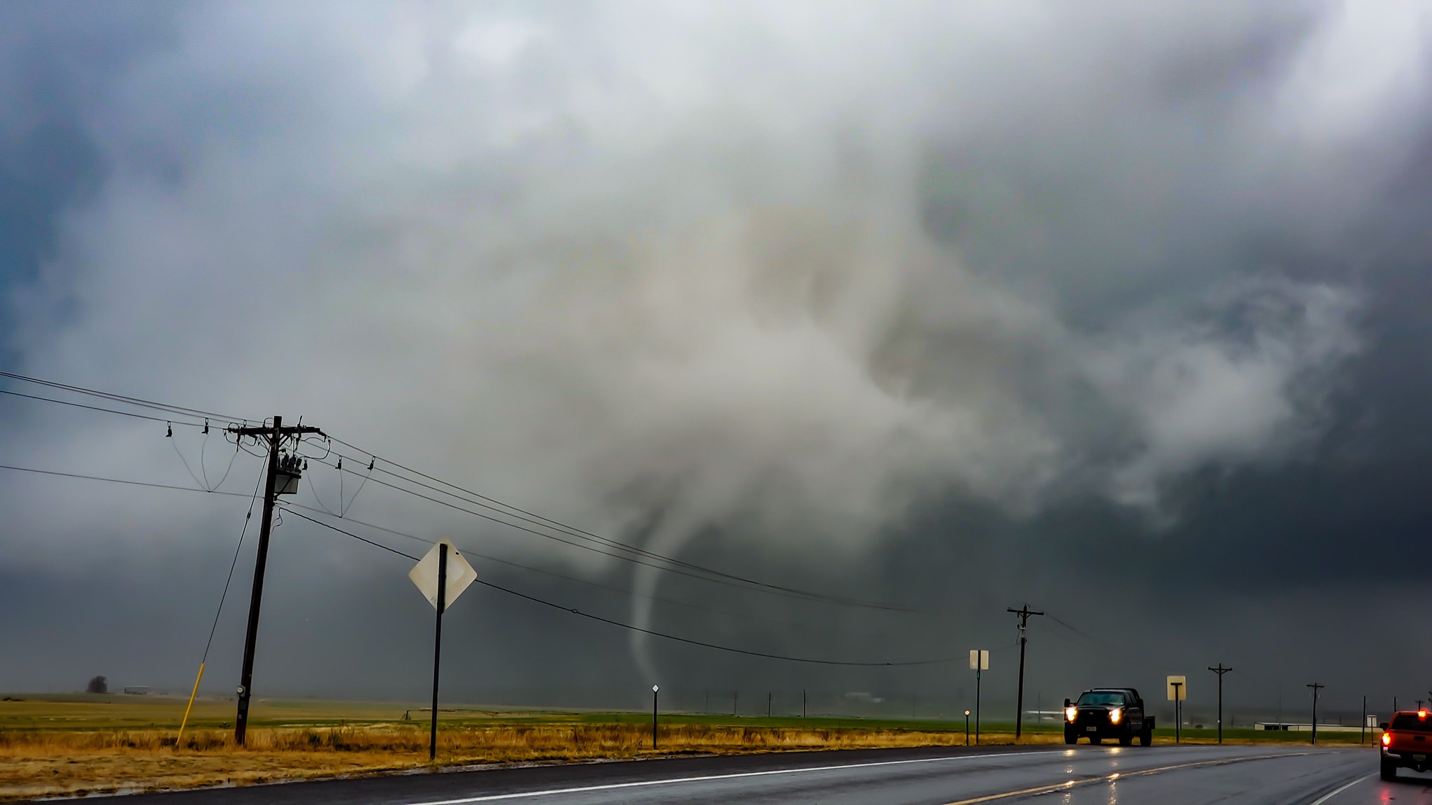
On the second anniversary of the bomb cyclone (https://www.weather.gov/ama/March13_2019_HighWinds), we were dealt another very potent upper level system which produced widespread hazards from heavy snow across the front range/Rockies to severe weather across the Southern High Plains. For us here in the Panhandles, we issued 13 tornado warnings and 10 severe thunderstorm warnings. This was the first tornado day of the 2021 convective season in our area, with eight confirmed tornadoes. We also saw three separate instances in which two tornadoes were in progress from the same parent thunderstorm at the same time.
A vigorous closed upper low was approaching the Four Corners region from the west. A warm front lifted north and northwest across all but the Oklahoma Panhandle and the northwest Texas Panhandle while a sharpening dryline was located over eastern New Mexico. The dryline preceded a Pacific cold front which was also located in eastern New Mexico and swept eastward later in the evening. A broken line of thunderstorms developed ahead of the dryline in eastern New Mexico and tracked north and east into the western and southwestern Texas Panhandle before continuing to move east across the remainder of the eastern Panhandles during the evening hours, growing upscale as the Pacific cold front swept eastward and overtook the dryline.
Tornadoes:
|
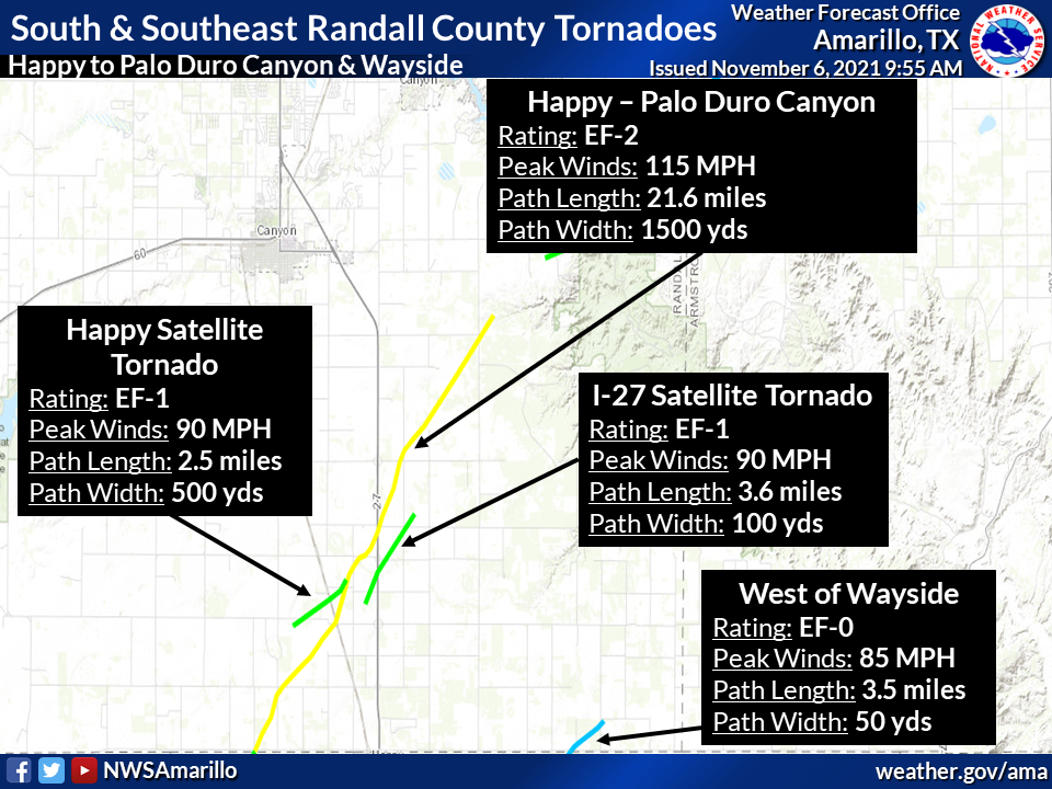
Tornado - Happy to Palo Duro Canyon
|
||||||||||||||||
|
Tornado - Happy Satellite
|
||||||||||||||||
|
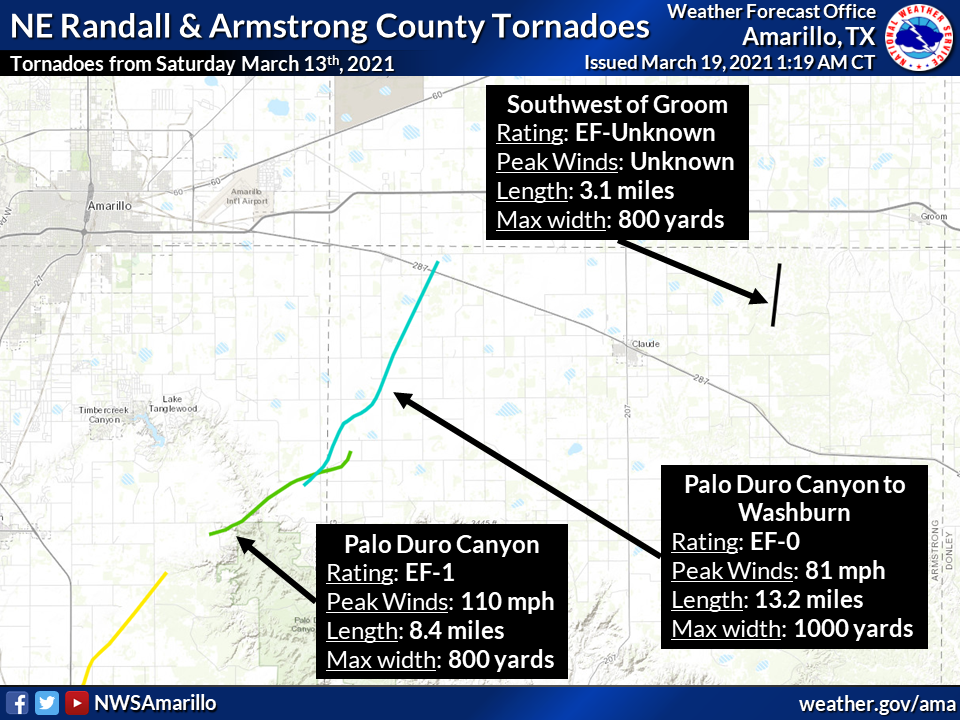
Tornado - Palo Duro Canyon
|
||||||||||||||||
|
Tornado - Palo Duro Canyon to Washburn
|
||||||||||||||||
|
Tornado - West of Wayside
|
||||||||||||||||
|
Tornado - Southwest of Groom
|
||||||||||||||||
|
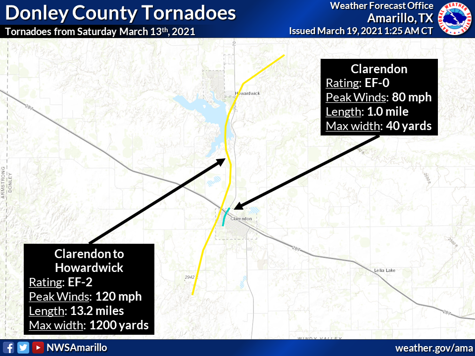
Tornado - Clarendon
|
||||||||||||||||
|
Tornado - Clarendon to Howardwick
|
||||||||||||||||
The Enhanced Fujita (EF) Scale classifies tornadoes into the following categories:
| EF0 Weak 65-85 mph |
EF1 Moderate 86-110 mph |
EF2 Significant 111-135 mph |
EF3 Severe 136-165 mph |
EF4 Extreme 166-200 mph |
EF5 Catastrophic 200+ mph |
 |
|||||
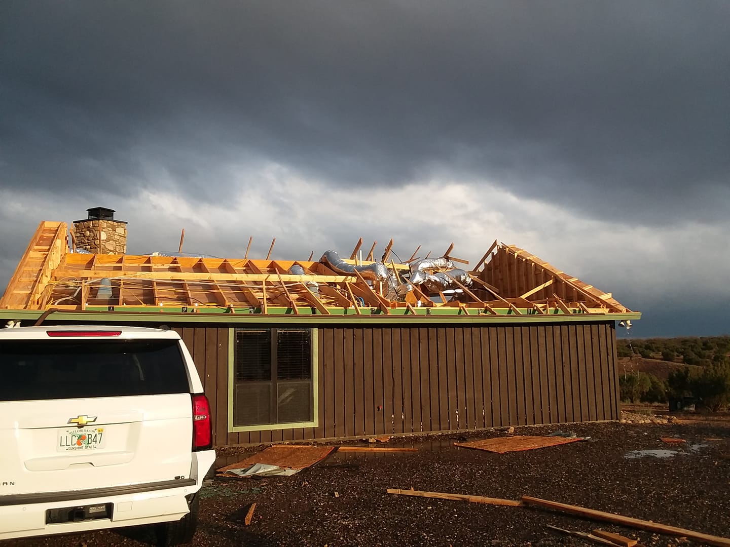
Photos & Video
Header
 |
 |
 |
 |
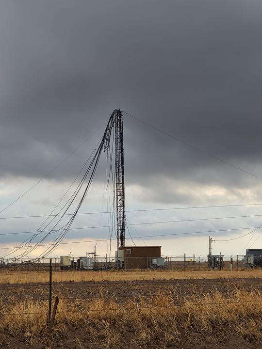
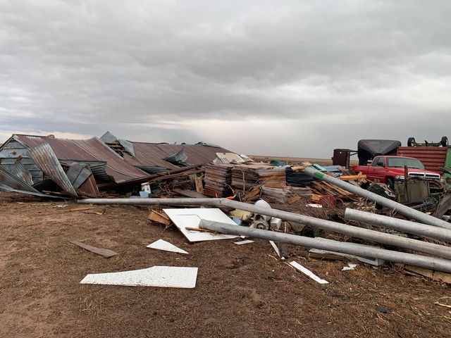
| Damaged cell phone tower (Amarillo OEM) |
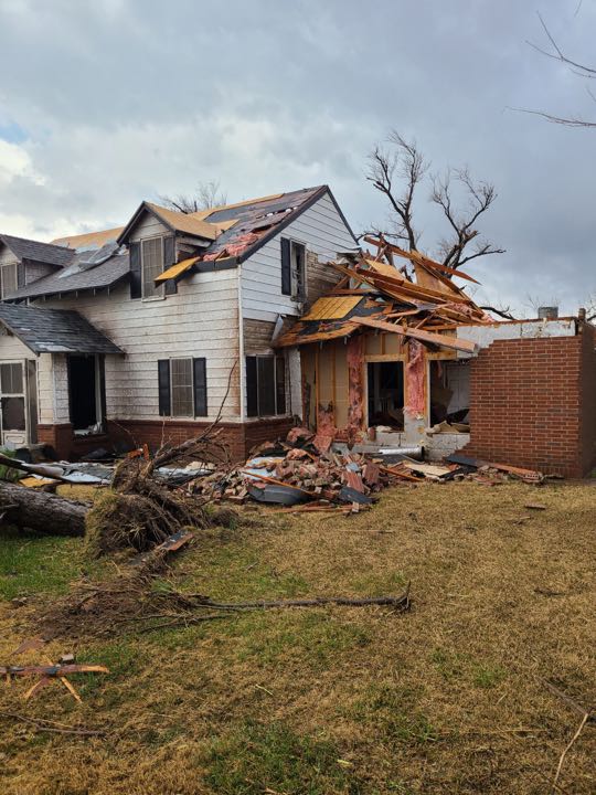
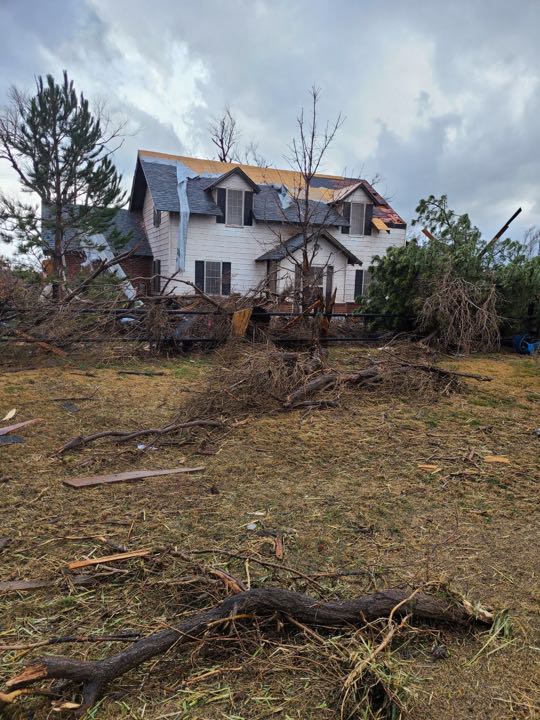
Damage to a home north of Happy (Amarillo OEM) |
Damage to a home north of Happy (Amarillo OEM) |
Damage to a home north of Happy (Amarillo OEM) |
 |
 |
 |
 |
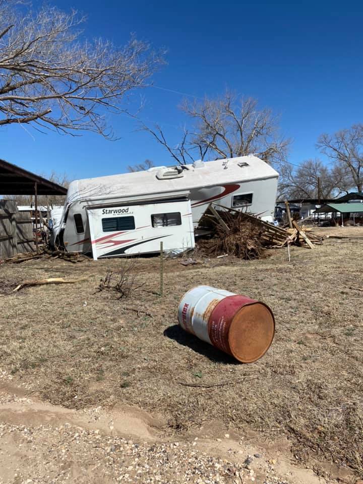
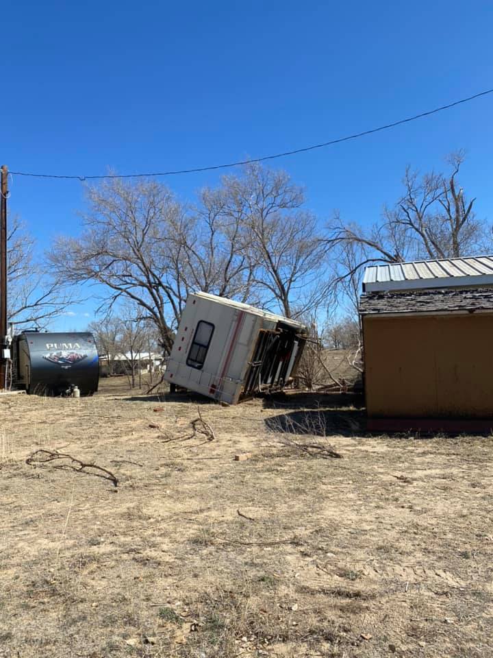
| Damage to an RV near Greenbelt Reservoir (Hallie Thompson) |
Damage to an RV near Greenbelt Reservoir (Hallie Thompson) |
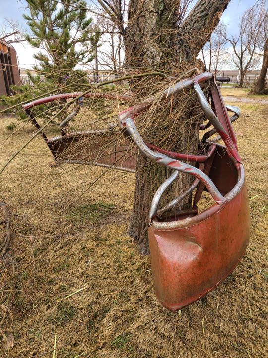
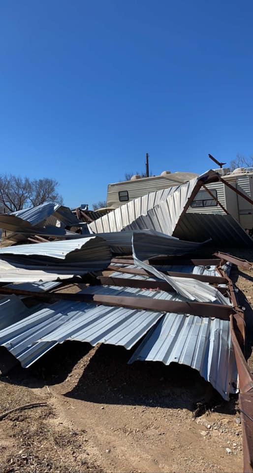
Damage to a shed near Greenbelt Reservoir (Hallie Thompson) |
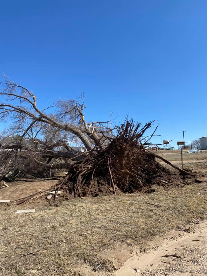
Tree uprooted near Greenbelt Reservoir (Hallie Thompson) |
 |
 |
 |
 |
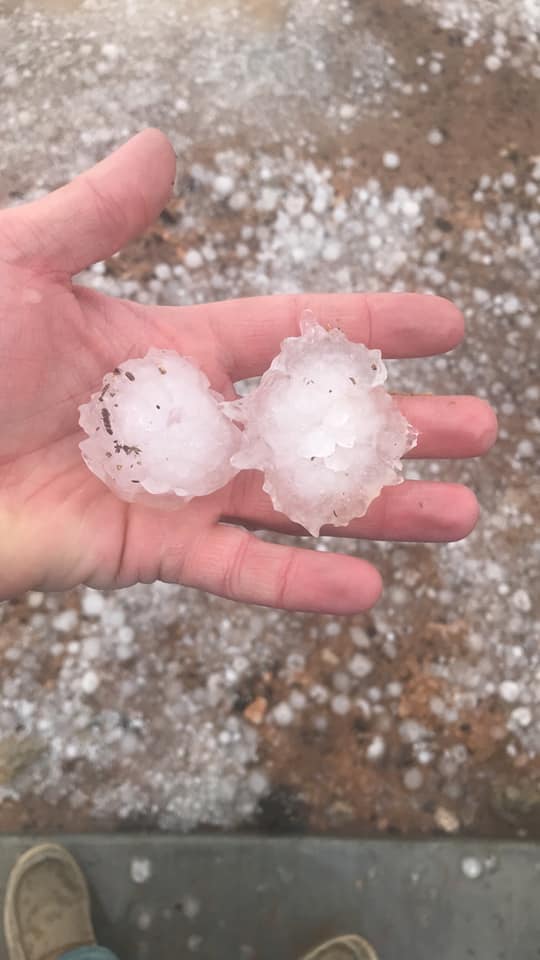
| Hail southwest of Claude (Brandon Armstrong) |
North of Happy (Jay McCoy) |
Clarendon (Amber Martin) |
North Clarendon (Kirk Michaelson) |
 |
 |
 |
|
| West Rim Palo Duro Canyon (Debbie Norris) |
FM 2250 & Hwy 1151 Armstrong County (Aaron VanWinkle) |
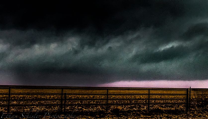
Looking southwest from northeast of Happy, TX (Ethan Schisler) |
Radar
Header
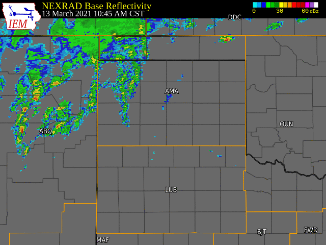 |
| Radar loop with warnings from the March 13th, 2021 severe weather event. Radar and warnings from NWS, image from Iowa Environmental Mesonet. |
| Radar velocity data from the supercell that spawned 4 tornadoes between Happy, Texas and Washburn, Texas on March 13th, 2021. The images follow the supercell as it moves northeast. This video features narration about the radar data and the tornado event. |
| Radar velocity data from the supercell that spawned 4 tornadoes between Happy, Texas and Washburn, Texas on March 13th, 2021. The images follow the supercell as it moves northeast. This video features minimal narration. |
Storm Reports
NOTE: Tornado reports are omitted from the table below. For information on the tornadoes that occurred, see the 'Tornado' tab above.
| Report Time (CST) | County | Location | Event Type | Magnitude | Source | Lat | Lon | Remark |
| 3:05pm | OLDHAM | VEGA | HAIL | 1 | PUBLIC | 35.25 | -102.43 | ACTUAL TIME IS 3:05 PM CST ON MARCH 13TH, WITH TIME ESTIMATED FROM RADAR. |
| 3:25pm | POTTER | 1 SSE AMARILLO | TSTM WND DMG | PUBLIC | 35.18 | -101.81 | DELAYED REPORT OF DOWNED POWERLINES. | |
| 3:42pm | POTTER | VALLEY DE ORO | HAIL | 1.25 | PUBLIC | 35.45 | -102.11 | ACTUAL TIME IS 3:42 PM CST ON MARCH 13TH, WITH HALF DOLLAR HAIL BEING SENT VIA TWITTER. |
| 3:50pm | POTTER | 1 SSE AMARILLO | TSTM WND DMG | PUBLIC | 35.18 | -101.81 | CORRECTS PREVIOUS TSTM WND DMG REPORT FROM 1 SSE AMARILLO. ACTUAL TIME IS 3:50 PM CST ON MARCH 13TH. DELAYED REPORT OF DOWNED POWERLINES. | |
| 3:58pm | MOORE | DUMAS | HAIL | 1 | FIRE DEPT/RESCUE | 35.86 | -101.96 | HAIL LASTED FROM ABOUT 358 PM TO 401 PM CST. |
| 3:59pm | ARMSTRONG | 5 S WASHBURN | HAIL | 0.75 | PUBLIC | 35.1 | -101.58 | REPORT FROM MPING: DIME (0.75 IN.). |
| 4:00pm | RANDALL | 3 N LAKE TANGLEWOOD | HAIL | 1.5 | COUNTY OFFICIAL | 35.1 | -101.78 | |
| 4:05pm | RANDALL | 3 NNW PALO DURO CANYON | TSTM WND GST | 76 | MESONET | 34.99 | -101.69 | MESONET REPORTED 3 ONE MIN OBS FROM 68 TO 76 MPH GUSTS. |
| 4:15pm | RANDALL | 4 NW PALO DURO CANYON | TSTM WND DMG | EMERGENCY MNGR | 34.99 | -101.72 | DAMAGE AT THE ENTRANCE TO PALO DURO CANYON STATE PARK OCCURRED BETWEEN 355 PM CST AND 415 PM CST . | |
| 4:22pm | RANDALL | 1 ENE PALO DURO CANYON | HAIL | 1.5 | PUBLIC | 34.95 | -101.65 | |
| 4:22pm | RANDALL | 2 NNW PALO DURO CANYON | HAIL | 1.5 | PUBLIC | 34.98 | -101.68 | ACTUAL TIME OF EVENT IS 4:22 PM CST ON MARCH 13TH. PING PONG BALL SIZED HAIL PICTURES SENT VIA TWITTER. |
| 4:25pm | ARMSTRONG | 1 W CLAUDE | HAIL | 1.75 | PUBLIC | 35.1 | -101.38 | CORRECTS PREVIOUS HAIL REPORT FROM 1 W CLAUDE. ACTUAL TIME IS 4:25 PM CST ON MARCH 13TH. |
| 4:25pm | RANDALL | 7 WSW AMARILLO | HAIL | 0.75 | PUBLIC | 35.16 | -101.93 | REPORT FROM MPING: DIME (0.75 IN.). |
| 4:30pm | ARMSTRONG | CLAUDE | FLOOD | PUBLIC | 35.11 | -101.37 | MINOR STREET FLOODING IN THE CITY OF CLAUDE. SOME ACCUMULATING HAIL BEING REPORTED AS WELL. 430 PM CST TO 600 PM CST. | |
| 4:32pm | ARMSTRONG | 1 WSW CLAUDE | HAIL | 0.75 | PUBLIC | 35.1 | -101.37 | REPORT FROM MPING: DIME (0.75 IN.). |
| 4:40pm | ARMSTRONG | CLAUDE | HAIL | 1 | PUBLIC | 35.11 | -101.36 | REPORT FROM MPING: QUARTER (1.00 IN.). |
| 4:47pm | ARMSTRONG | 3 ESE CLAUDE | HAIL | 1 | PUBLIC | 35.09 | -101.31 | REPORT FROM MPING: QUARTER (1.00 IN.). |
| 4:50pm | CARSON | 1 SW PANHANDLE | HAIL | 2.75 | PUBLIC | 35.33 | -101.4 | |
| 5:00pm | ARMSTRONG | 2 E CLAUDE | HAIL | 1.25 | PUBLIC | 35.11 | -101.33 | DELAYED REPORT OF HALF DOLLAR HAIL FROM TWITTER. ACTUAL TIME OF REPORT IS 5 PM CST ON MARCH 13TH. |
| 5:28pm | DONLEY | 1 E CLARENDON | FLOOD | PUBLIC | 34.93 | -100.88 | REPORT FROM MPING: RIVER/CREEK OVERFLOWING; CROPLAND/YARD/BASEMENT FLOODING. | |
| 5:40pm | DONLEY | 3 NE HOWARDWICK | FLOOD | PUBLIC | 35.07 | -100.89 | REPORT FROM MPING: RIVER/CREEK OVERFLOWING; CROPLAND/YARD/BASEMENT FLOODING. | |
| 5:47pm | GRAY | ALANREED | FLOOD | PUBLIC | 35.21 | -100.73 | REPORT FROM MPING: RIVER/CREEK OVERFLOWING; CROPLAND/YARD/BASEMENT FLOODING. | |
| 6:59pm | ROBERTS | MIAMI | HAIL | 1 | STORM CHASER | 35.69 | -100.64 | |
| 7:05pm | WHEELER | 1 SSE MOBEETIE | TSTM WND DMG | TRAINED SPOTTER | 35.52 | -100.44 | CORRECTS PREVIOUS TSTM WND DMG REPORT FROM 1 SSE MOBEETIE DUE TO TIME ZONE CHANGE ISSUE. LATE REPORT OF MULTIPLE TREES DOWNED DUE TO THUNDERSTORM WINDS. TIME ESTIMATED FROM RADAR. | |
| 7:27pm | GRAY | 1 NE PAMPA | HAIL | 1 | EMERGENCY MNGR | 35.56 | -100.94 | |
| 7:28pm | GRAY | 1 NNW PAMPA | HAIL | 1 | TRAINED SPOTTER | 35.55 | -100.97 | |
| 7:39pm | GRAY | 4 S PAMPA | TSTM WND GST | 75 | STORM CHASER | 35.49 | -100.97 | |
| 7:56pm | GRAY | 7 SSE CODMAN | HAIL | 1.25 | STORM CHASER | 35.55 | -100.72 | CHASERS SAID THERE WAS LOTS OF QUARTER SIZE TO HALF DOLLAR SIZE HAIL STONES. HAIL ACCUMULATING ON THE GROUND UP TO 2 INCHES. REALLY STRONG WINDS ESTIMATING WITHOUT DESCRIPTORS ABOUT 70 TO 80 MPH. |
| 7:59pm | ROBERTS | MIAMI | TSTM WND GST | 80 | STORM CHASER | 35.7 | -100.64 | MEASURED FROM WEATHER INSTRUMENT ON VEHICLE. |
| 8:20pm | BEAVER | 8 W SLAPOUT | TSTM WND GST | 60 | MESONET | 36.62 | -100.26 | |
| 8:44pm | HEMPHILL | CANADIAN | HAIL | 1 | PUBLIC | 35.91 | -100.38 | PICTURE ON TWITTER. |
| 8:53pm | HEMPHILL | CANADIAN | FLASH FLOOD | PUBLIC | 35.91 | -100.38 | CAR HALF UNDERWATER ON TWITTER. | |
| 8:53pm | HEMPHILL | CANADIAN | TSTM WND GST | 70 | TRAINED SPOTTER | 35.91 | -100.38 | |
| 8:55pm | HEMPHILL | 1 SW CANADIAN | TSTM WND GST | 62 | AWOS | 35.9 | -100.4 | AWOS STATION KHHF CANADIAN (AWOS). |
| 9:00pm | BEAVER | 1 SSW BEAVER | TSTM WND GST | 59 | MESONET | 36.8 | -100.53 | |
| 9:14pm | HEMPHILL | CANADIAN | FLASH FLOOD | PUBLIC | 35.91 | -100.38 | FLOODING HALF WAY UP CAR TIRES IN CANADIAN. VIDEO ON TWITTER. |
Rain Reports
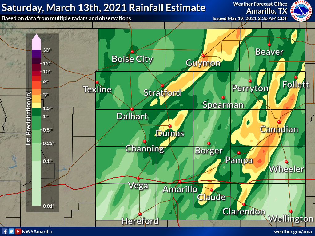 |
| Estimated precipitation that fell from 6am CST March 13th through 7am CDT March 14th. (NOAA/NWS/NCEP Unrestricted Mesoscale Analysis) |
The reports listed below come from automated rain gauges across the Panhandles. They may not exactly match the map above, since the map uses precipitation estimates from multiple radars and adjusts these estimates using rain gauge observations to minimize overall error, especially in the majority of the surrounding area that has no nearby gauge.
:ID   ASOS       24HR
:     LOCATION   PCPN
:....................
AMA : Amarillo : 0.59
BGD : Borger   : 0.37
DHT : Dalhart  : 0.77
GUY : Guymon   : 1.66
:
:ID   AWOS               24HR
:     LOCATION           PCPN
:............................
HHF : Canadian Airport : 2.92
HRX : Hereford Airport : 0.01
PPA : Pampa Airport    : 1.27
PYX : Perryton Airport : 0.93
:
:ID   MESONET                     24HR
:     LOCATION                    PCPN
:.....................................
:
 Texas Panhandle
ADXT2 : Adrian 6WSW             : 0.11
ANXT2 : Amarillo 15NNW          : 0.36
ASOT2 : Amarillo 7SSE           : 0.53
AMNT2 : Amarillo 9NNE           : 0.48
BLST2 : Bootleg 11WNW           : 0.06
BGXT2 : Borger 7E               : 0.75
BYST2 : Boys Ranch 1WSW         : 1.15
CNST2 : Canadian 6E             : 1.27
CEST2 : Clarendon 2W            : 0.82
CLUT2 : Claude 12SSW            : 2.16
DOZT2 : Dozier 3W               : 0.02
FIHT2 : Fritch 1WNW             : 0.36
GNIT2 : Goodnight               : 0.46
HEST2 : Hereford 2NW            : 0.07
MLMT2 : Lake McClellan 2NW      : 0.88
MCST2 : Mclean 1E               : 0.32
PDJT2 : Palo Duro 4E (JA Ranch) : 1.02
PDFT2 : Palo Duro Canyon Floor  : 0.89
PDST2 : Palo Duro Canyon Rim    : 0.48
PDWT2 : Palo Duro Reservoir 1NW : 0.84
PAMT2 : Pampa 2E                : 0.41
PHLT2 : Panhandle 1SSW          : 2.25
ROMT2 : Romero 11SSW            : 0.77
STNT2 : Stinnett 1NNW           : 0.26
SFOT2 : Stratford 4WNW          : 0.56
UMST2 : Umbarger 3NNE           : 0.07
VGST2 : Vega 4E                 : 0.42
WGTT2 : Wellington 6SE          : 0.47
:
 Oklahoma Panhandle
BVSO2 : Beaver 1SSW             : 1.01
BCSO2 : Boise City 3SSE         : 0.57
EVSO2 : Eva 12NE                : 0.60
GDSO2 : Goodwell 2E             : 1.62
HKSO2 : Hooker 1W               : 2.14
KTSO2 : Kenton 5SE              : 1.07
SPSO2 : Slapout 8W              : 0.95
:
:ID     RAWS      24HR
:       LOCATION  PCPN
:.....................
:
CEDT2 : Cedar   : 0.22
WHRT2 : Wheeler : 0.32
BLGT2 : Bootleg : 0.21
:
:ID     SUPPLEMENTAL   24HR
:       DATA           PCPN
:..........................
:
LEFT2 : Lefors       : 1.49
GSRT2 : Goodnight 5N : 1.08
HTBT2 : Hereford     : 0.06
WLRT2 : Wheeler      : 0.11
Additional Information
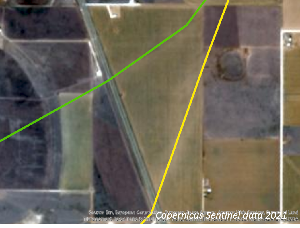
Copernicus Sentinel Data
Satellite data from the Copernicus Sentinel satellite revealed scoured ground from the large tornado on either side of I-27 (Copernicus Sentinel data 2021). Our survey tracks are overlaid on photo 2 and 3.
Photo 1:Wide view with annotations.
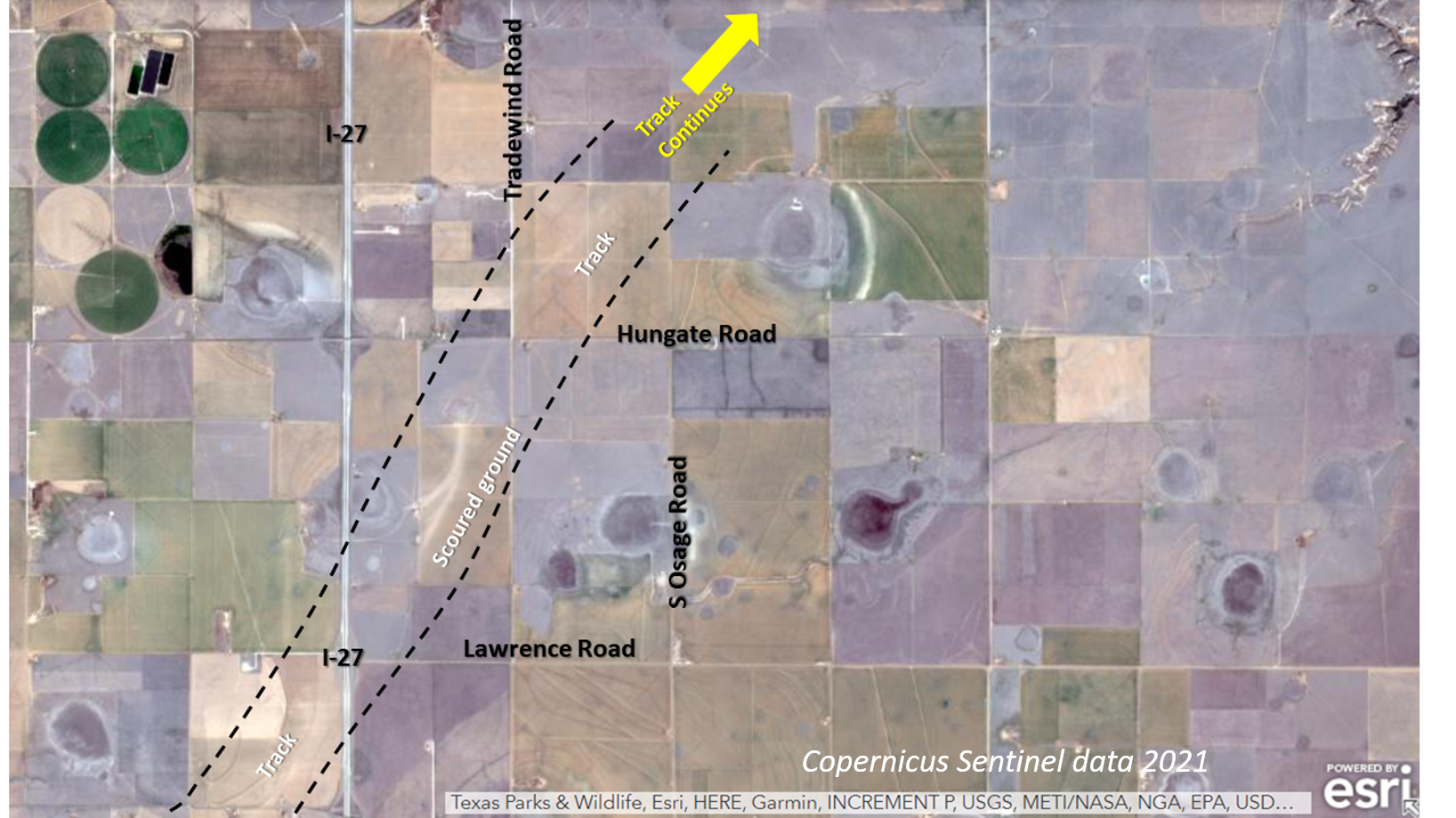
Photo 2: Scoured ground shows where tornadoes merged with overlaid survey track east of I-27.
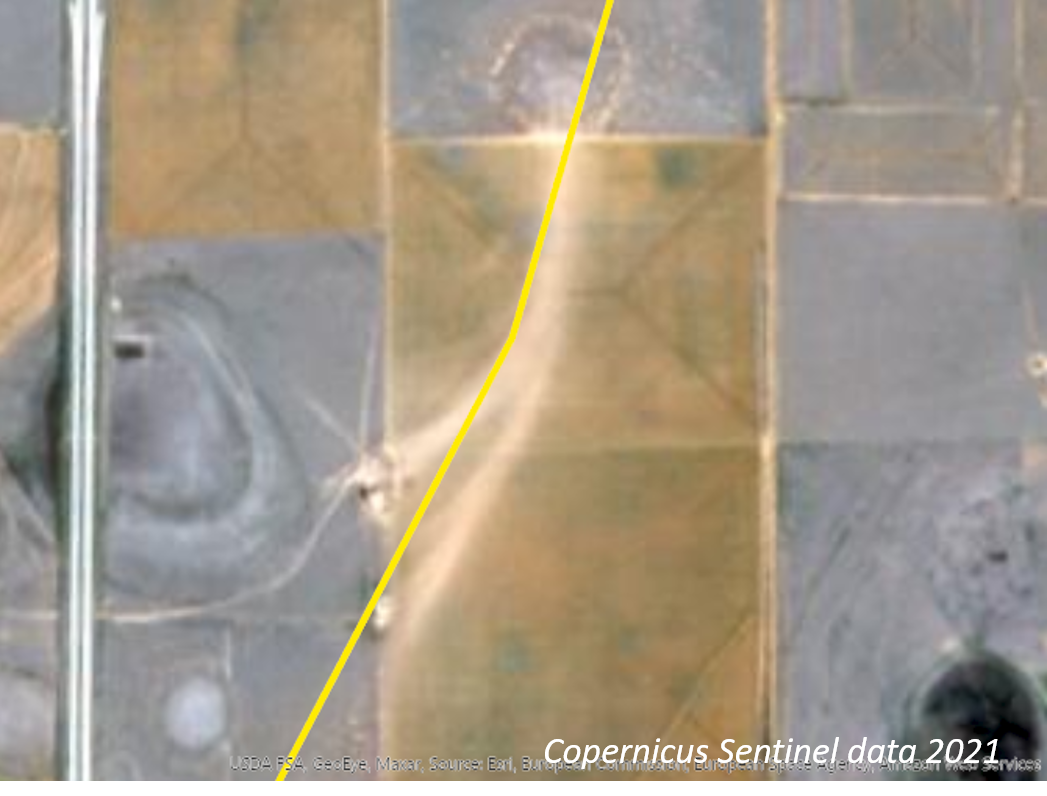
Photo 3: Scoured ground with tornado survey tracks overlaid.
 |
Media use of NWS Web News Stories is encouraged! Please acknowledge the NWS as the source of any news information accessed from this site. |
|