
Dangerous heat will expand from the Gulf Coast into the Southern Plains and Desert Southwest through week's end. Additional extreme heat impacting the Pacific Northwest will shift to the northern Plains by the weekend. Tropical Storm Bertha is expected to continue to impact portions of the northern Gulf Coast from the western Florida Panhandle to southeastern Louisiana through tonight. Read More >
|
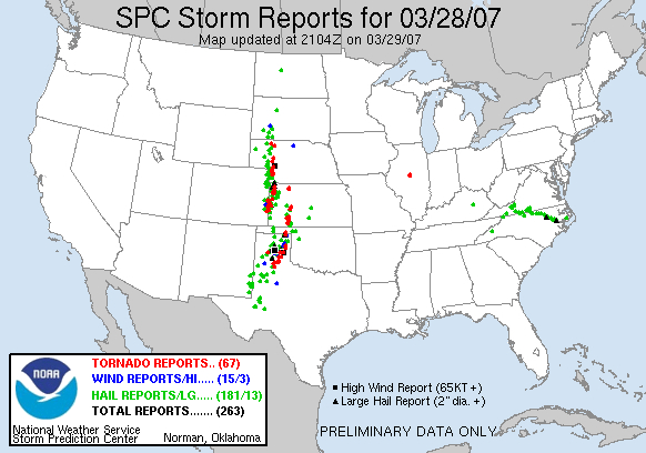
March 28-29, 2007 Tornado Outbreak The following pages will provide an overview of the severe weather events that took place across the Texas and Oklahoma Panhandles from the afternoon hours on Wednesday, March 28 through Thursday morning on March 29, 2007. |
|
In total, there were 15 tornadoes! This was the largest March tornado outbreak in the history of the Texas and Oklahoma Panhandles. For storm surveys, click here. A very dynamic weather pattern brought severe weather, including large tornadoes, to the Central United States starting during the afternoon on Wednesday, March 28 through the early morning hours on Thursday, March 29th. Severe weather reports associated with this pattern extended from southwestern Texas into the Dakotas |
||
 |
||
|
In addition to the tornadoes, hail and winds, many communities were faced with flash flooding as these storms moved over the same areas time after time. This caused flooding in Donley, Gray, and Lipscomb counties where water invaded some homes. So what caused this widespread severe weather event? The following pages will discuss the large scale synoptic pattern in place and also the small scale environment that helped trigger the tornadoes. |
||

