NWS Birmingham, Alabama
Weather Forecast Office
How Might the Currently Developing El Nino Affect Central Alabama?
With a developing strong El Nino event currently underway, you might be wondering what this could mean for Central Alabama as we head into the fall and winter season. Let’s take a look and see what the upcoming cool season might hold for us when we look at some years with similar type El Nino events.
Since 1950, there have been six similarly strong El Nino events. These occurred in 1957, 1965, 1972, 1982, 1991 and 1997. Let’s see what happened in those years.
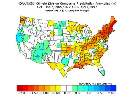
If we take a composite of those years for October, what we find is that Octobers tended to be drier than normal. Looking at the graphic below, you can see that Central Alabama tended to have rainfall on the order of one-half to one inch below normal for the month.
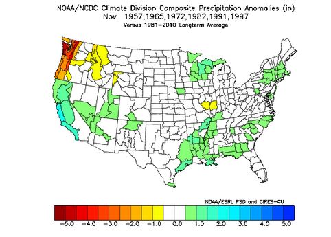
Next, let’s see how Novembers shaped up in general. Looking at the composite graphic for November, we see that precipitation across Central Alabama begins to show some increase with amounts generally near to slightly above normal, especially in our southern counties.
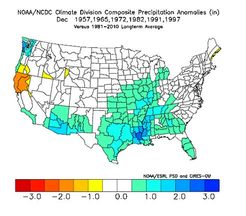
Finally, as we move into December for these years, we see that rainfall increases across Central Alabama, with amounts generally averaging up to over an inch above normal.
So, based on previous years having strong El Nino events, it appears that what might begin as a somewhat dry fall season for Central Alabama in October could gradually transition to a wetter weather pattern as we move into November, and especially December. Of course, there are other factors that could come into play, such as if a tropical cyclone were to affect portions of the area in October. It will be interesting to watch weather patterns as we move through the fall and see how this year compares to other previous years that experienced the strong El Ninos.
Current Hazards
National Outlooks
Tropical
Local Storm Reports
Public Information Statement
Graphical Hazardous Weather Outlook
Current Conditions
Regional Weather Roundup
Rivers and Lakes
Drought Monitor
Forecasts
Fire Weather
Aviation Weather
Graphical Forecasts
Forecast Discussion
Air Quality
Climate and Past Weather
Past Events
Storm Data
Tornado Database
Daily Rainfall Plots
Tropical Cyclone Reports
Monthly Climate
Annual Climate
Warnings and Other Products
Tornado Warnings
Severe Thunderstorm Warnings
Flash Flood Warnings
Winter Weather Warnings
Special Weather Statements
Non-Precipitation Warnings
Flood/River Flood Warnings
Productos en Español
Conciencia y Preparación
Previsión de 7 Días
Weather Safety
NOAA Weather Radio
Severe Weather Preparedness
Severe Safety Rules
Tornado Safety Rules
Severe Safety w/ ASL
Awareness Weeks
Severe Weather
Hurricane Preparedness
Summer Safety Campaign
Winter Weather
US Dept of Commerce
National Oceanic and Atmospheric Administration
National Weather Service
NWS Birmingham, Alabama
465 Weathervane Road
Calera, AL 35040
205-664-3010
Comments? Questions? Please Contact Us.

