There can be other hazards besides precipitation and thunderstorms. Heat, cold, fog, dust, and wind can all have an impact. That is why the National Weather Service issues watches, warnings, and advisories related to these hazards. Click here for the latest NPW
|
· Fire Weather Watch or Red Flag Warning (RFW) |
|
|
A "Fire Weather Watch" is issued when there is a potential of Red Flag conditions during the next 12 to 72 hours. A "Red Flag Warning" is issued when ongoing or forecast weather conditions can lead to or aggravate existing wildfires. The criteria is as follows:
|
|
|
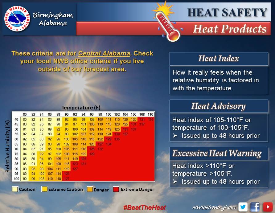
· Excessive Heat Watch, Excessive Heat Warning or Heat Advisory (NPW) |
|
|
An "Excessive Heat Watch" is issued when excessive heat warning criteria is possible generally within the 12 to 48 hour time frame. An "Excessive Heat Warning" is issued when the Heat Index will reach 110 degrees or more OR the air temperature is expected to be greater than 105 degrees. A "Heat Advisory" is issued when the Heat Index will reach 105 degrees or more OR the air temperature is expected to reach 100-105 degrees. |
|
|
· Freeze Watch or Freeze Warning (NPW) |
|
|
A "Freeze Watch" is issued when warning criteria is possible generally within the 12 to 48 hour time frame. A "Freeze Warning" is issued if temperatures are expected to be at or below 32 degrees Fahrenheit, mainly during the growing season. In the fall, this warning will be discontinued when a widespread killing freeze occurs or Thanksgiving Day arrives, whichever comes first. This product can again be issued in the spring after March 15th. A "Hard Freeze" refers to temperatures of 15 degrees Fahrenheit or colder. The Freeze Watch and Warning products are issued anytime these hard freeze conditions are possible. |
|
|
· High Wind Watch, High Wind Warning or Wind Advisory (NPW) |
|
|
A "High Wind Watch" is issued when high wind warning criteria is possible generally in the 12 to 48 hour time frame. A "High Wind Warning" is issued for sustained winds of 40 mph or higher, for 1 hour or longer, or gusts equal to or greater than 58 mph. A "Wind Advisory" is generally issued for sustained winds of 17 to 39 mph that will persist for an hour or more, or gusts of 29 to 56 mph. |
|
|
· Dense Fog Advisory (NPW) |
|
|
A "Dense Fog Advisory" is issued when visibilities are expected to be 1/4 mile or less for any extended period of time over at least 2 counties. If temperatures are below freezing, ice could form on bridges and overpasses. |
|
|
· Frost Advisory (NPW) |
|
|
A "Frost Advisory" is issued when frost formation is possible during the growing season. This occurs when temperatures drop into the 33 to 36 degree range, but may occur at slightly higher temperatures. These advisories are issued until a widespread freeze occurs or Thanksgiving Day arrives, whichever comes first. The product is again issued after March 15th.
|
|

