RELATIONSHIPS BETWEEN CONDITIONAL SYMMETRIC INSTABILITY, THUNDER, & HEAVY SNOWFALL DURING THE "STORM OF THE CENTURY"
Tom Bradshaw
National Weather Service Forecast Office
Birmingham, Alabama
1. Introduction
During the nighttime hours of 12-13 March 1993, an intense surface cyclone tracked northeastward out of the Northern Gulf of America, across the Florida Panhandle, into Eastern Georgia. Immortalized as the "Storm of the Century", this system subjected Alabama to wintertime conditions unprecedented in the state's history.
Storm snowfall totals for Alabama are displayed in Fig. 1. While no portion of the state escaped accumulation, the storm spent most of its fury within a broad swath extending from West Central to Northeast Alabama, including the population centers of Birmingham, Tuscaloosa, and Gadsden. Birmingham was particularly hard hit, with some areas of the metropolitan area receiving up to 33 cm (13 inches) of snow. The record-breaking snowfall strangled the city for three days, knocking out power over wide areas, cutting virtually all transportation links, and significantly disrupting most human activities.
In the Birmingham area, an interesting sidelight to this event was the conspicuous presence of thunderstorms during the height of the storm. Thunder and in-cloud and cloud-to-ground lightning occurred intermittently throughout the period from 0600 UTC to 1200 UTC, 13 March. Thunder was also noted at other locations across Northern and Central Alabama during the same time period, as well as across much of Southern Alabama earlier in the evening.
Any episode of heavy snowfall in the Deep South, especially one accompanied by persistent lightning, is noteworthy. Adding to the novelty of the event, however, is the fact that the thunderstorms apparently occurred within an unconditionally stable environment, as evidenced by nearby upper air soundings. Fig. 2a depicts the 0000 UTC 13 March rawinsonde observation taken at Centreville, AL (CKL) a few hours prior to the onset of thunder at Birmingham. Upon initial inspection of this profile, prospects for convection would indeed seem remote. Aside from the +16 lifted index, which would certainly deter any surface-based convection, there does not appear to be any conditional instability aloft which might be realized through synoptic or mesoscale lifting. The 1200 UTC CKL sounding (Fig. 2b), made shortly after the cessation of area thunder reports, exhibits a similar, unconditionally stable environment.
In the absence of conventional vertical instability, some alternate mechanism must be sought to account for the observed convection. Conditional symmetric instability (CSI), manifested as "slantwise convection", likely was the vehicle for this unusual event. This paper's purpose is to describe the characteristics of CSI and its role in promoting thunderstorm development over Birmingham during the "Storm of the Century". A second goal of this study is to provide evidence that CSI acted in concert with upper level frontogenesis to enhance snowfall over Northern Alabama during this event.
2. CSI and thunderstorm development
The concept of symmetric instability has been explored in detail by Bennetts and Hoskins (1979), and Emmanuel (1979, 1983a, 1983b). Fundamentally, CSI results from a combination of forces acting simultaneously along different planes of the atmosphere. As is well known, an uneven distribution of gravitational forces in the vertical can give rise to convective instability. Similarly, horizontal inertial instability can develop in strongly anticyclonically-sheared regimes, due to an imbalance of centrifugal forces. CSI environments typically exhibit weak convective and inertial stability for strictly vertical or horizontal motions. However, air parcels displaced along certain sloped, or "slantwise" trajectories may attain positive buoyancy due to a unique combination of gravitational and centrifugal forces. While convective available potential energy (CAPE) values within these environments are typically much smaller than those associated with upright convection, sufficient energies are frequently present to support the formation and maintenance of thunderstorm cells. There is growing evidence supporting the role CSI plays in the development of some types of thunderstorms, particularly those occurring within strongly baroclinic regimes. In an extensive climatological study, Colman (1990) categorized nearly all wintertime thunderstorms over the Southeast U.S. as being "elevated" (occurring above frontal inversions, within regions of little or no CAPE). The study went further in suggesting that CSI played a key role in the development of much of this convection.
Investigations of CSI (e.g. Lussky (1989), and Snook (1992)) normally involve cross-sections of geostrophic angular momentum,  , and equivalent potential temperature,
  , constructed normal to the 1000-500 mb thermal wind. Here,
  , where
  is the component of geostrophic wind normal to the cross-section, x is the distance from the end of the cross-section, and f is the coriolis parameter. CSI exists in those saturated regions where the slope of is less than that of . Just as ordinary conditional instability is present where
  for vertically displaced parcels, moist symmetric instability is identified in those saturated regions where, following a sloping momentum isopleth upward,
  .
.
Ideally, cross-sections of and should be derived from objective analyses of high vertical resolution height, temperature, and moisture data. A more expedient, though cruder method for obtaining momentum data involves the use of gridded model data, via PCGRIDDS (PC GRidded Interactive Display and Diagnostic System). This study utilized mandatory-level geostrophic wind data from the NGM analysis fields at 0000 UTC and 1200 UTC, 13 March. Values of normal to the selected cross-sections were vertically interpolated at 50 mb increments between 300 mb and the surface; these data were subsequently used to obtain estimates of . Cross-sections of were constructed directly from high vertical resolution temperature and moisture data obtained from regional rawinsonde observations.
A cross section of and for 0000 UTC 13 March, extending from west of Nashville, Tennessee to west of Tampa, Florida, is displayed in Fig. 3. A deep layer of CSI from the surface to around 650 mb can be seen over Southeast Alabama, stretching northward to near CKL. Clearly, sufficient potential energy is present to support slantwise convection over Central Alabama at this point in the storm's history. In addition, Fig. 3 reveals a layer of near-neutral symmetric stability between 750 and 575 mb extending well into North Central Alabama. This raises the possibility that convection within the Birmingham metropolitan area, too, was a manifestation of slantwise processes.
A second cross-section for 1200 UTC 13 March, constructed from near Little Rock, Arkansas to west of Savannah, Georgia, is shown in Fig. 4. A large area of CSI exists at this time over Central Alabama below 650 mb, with near-neutral symmetric conditions (identified by nearly parallel and isopleths) surrounding this region. CSI apparently persisted over Central Alabama throughout the night, and it is likely that it played a role in the development of the Birmingham area thunder. The presence of a quasi-neutral symmetric state over much of this area is also noteworthy, since it may indicate the occurrence of symmetric moist adiabatic adjustment between 0000 UTC and 1200 UTC. As discussed by Emmanuel (1983a,b), a symmetrically unstable atmosphere will strive to regain neutrality, usually within a several hour period. It is likely that any convective available potential energy which may have been present during the night of 12-13 March was exhausted during the thunderstorm episode, when air parcels were probably most buoyant. This is consistent with observations of other CSI events reported by Emmanuel (1988).
As seen in Fig. 3, a prominent region of conditional instability (CI) existed over Southern Alabama and Florida, within the warm sector of the strengthening surface low. Widespread shower and thunderstorm activity was occurring over this area at the time, most likely triggered by synoptic-scale forcing. In light of this, there is some question as to whether CI could have developed over North Central Alabama after 0000 UTC, thus playing a role in the Birmingham thunderstorms. This is an important issue, since as Moore and Lambert (1993) noted, the presence of ordinary CI will easily overwhelm any influence of slantwise instability.
A review of the 0000 UTC CKL sounding (Fig. 2a) reveals a very stable layer from the surface to the base of a temperature inversion at around 800 mb. Above this point, however, the atmosphere is less unconditionally stable, and may possess potential for additional destabilization, provided a favorable combination of differential advection, or sufficient layer lifting were to occur. An examination of the gridded 700 and 500 mb analyses for 0000 UTC 13 March (not shown) reveals the presence of warm air advection in roughly equal amounts at both levels, resulting in little or no net lapse rate increase. Weak moisture advection is noted over the region at this time; however, the CKL sounding is already close to saturation within this layer, so the potential for increased destabilization due to this process also is limited. Significant destabilization due to layer lifting can likely be discounted for this same reason. Forecasts of net vertical displacement from the NGM-based Trajectory model did indicate nearly 180 mb of lift at 700 mb between 0000 UTC and 1200 UTC 13 March. However, even if one modifies the 0000 UTC CKL sounding assuming this amount of lift between 700 and 500 mb, the resulting profile at best will approach a moist adiabatic lapse rate, while yielding no positive buoyant energy. With CI apparently confined to Southern Alabama and Southeast Georgia throughout the storm, symmetric instability remains the most likely source for the convection observed over the Birmingham metropolitan area.
Apart from the cross-section data, there were observational clues that CSI was present over Alabama during this episode. Mesoscale cloud and precipitation bands aligned parallel to the thermal wind are common characteristics of CSI environments. Prior to, and during the period of thunder, meteorologists at WSFO Birmingham observed east-west oriented bands of precipitation on the CKL WSR-57 radar over Central and North Central Alabama, propagating slowly northward. GOES infrared satellite imagery also displayed some evidence of banded enhancements within the overall cloudfield across Alabama and Western Georgia during the storm. WSR-88D radar products were unavailable for the Alabama area during this event. This is unfortunate, as high-resolution reflectivity and velocity data could have been utilized to examine the structure of the convective cells, as well as the evolution of the shear environment over the region during the thunderstorm episode.
3. CSI, frontogenetical forcing, and enhanced snowfall
In the preceding section, it was suggested that CSI played an ancillary role in the "Storm of the Century" by providing an environment for thunderstorm development. There is also evidence that CSI directly enhanced snowfall across North Central Alabama by strengthening the upward branch of a frontogenetical circulation over the area.
Frontogenesis and its attendant ageostrophic circulations have been the focus of numerous studies through the years, notably that of Hoskins and Bretherton (1972). Bluestein (1986) provides a good summary of the process of frontogenesis and associated circulations. Basically, upper-level frontogenesis proceeds as geostrophic confluence increases the horizontal temperature gradient, resulting in increased and decreased thicknesses on the warm and cold sides of the frontal zone, respectively. This in turn intensifies the pressure gradient across the front, as the isobars attain greater slope. Since this process upsets the thermal wind balance, an ageostrophic response in the form of a vertical, thermally-direct circulation (DTC) must arise to restore equilibrium.
The presence of frontogenesis within a CSI environment can have major ramifications for storm precipitation patterns. Emmanuel (1985) theorized that vertical frontogenetical circulations may become greatly enhanced within regions of weak or negative symmetric stability. Specifically, the ascending branch of a DTC, which usually follows a sloping trajectory up the warm side of the frontal boundary, can intensify significantly. This phenomenon may occur if the potential vorticity of the warmer air encompassing the rising branch approaches zero, as it does within saturated, symmetrically neutral regimes. If the potential vorticity of the descending branch is not as small as that of its counterpart, which is usually the case for unsaturated, sinking air, then this branch will see no corresponding increase in intensity. The atmosphere responds to this mass imbalance by constricting the horizontal scale of the rising branch into a narrow band, typically 50-200 km wide.
In recent years, quasi-geostrophic (QG), or Q-vector diagnostics have been used to investigate frontogenetical forcing (Moore and Blakely (1988), Lussky (1989)). A Q-vector, expressed as:
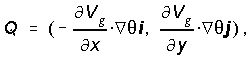 (1)
(1)represents a generalization of the classical frontogenetical function defined by Petterssen (1956). As Lussky (1989) noted, an advantage of Q-vectors is that they are directly proportional to the magnitude of geostrophic frontogenetical forcing, thus providing a simple means for diagnosing vertical motion. However, Q-vectors should be used very cautiously in evaluating later stages of frontogenesis, since QG frontogenesis by definition neglects thermal advection by the ageostrophic wind.
The PCGRIDDS system represents a useful tool for analyzing regions of quasi-geostrophic frontogenetical forcing. For this study, fields of QG frontogenesis were generated using the following relationship (from Moore and Blakely (1988)):
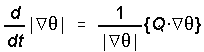 , (2)
, (2)Depictions of 850 and 700 mb QG frontogenesis for 0000 UTC 13 March, derived from the gridded NGM initial analyses, are displayed in Fig. 5 and Fig. 6, respectively. At 850 mb, an axis of maximum frontogenesis extends from the southwest through East Central Alabama. A slightly weaker, but similarly oriented axis can be seen at 700 mb, displaced 100-200 km farther northwest over Central Mississippi, Northwest Alabama, and Central Tennessee. This pattern is indicative of a northwestward sloping frontal surface, with the ascending warm-side branch of the DTC located at this time over Central Alabama. The 850 and 700 mb frontogenesis maxima at 1200 UTC (not shown) were located over Western South Carolina and Extreme Northeast Georgia, respectively; from this it can be inferred that the ascending lower tropospheric branch of the DTC remained over Northern Alabama for most of the night, within or near the regions of near-neutral symmetric stability seen in Fig. 3 and Fig. 4. A number of elements probably collaborated to produce the extreme snowfall across Northern Alabama. However, based on the co-location of the axes of frontogenesis, CSI, and maximum snowfall, it appears likely that the presence of a CSI environment was important in intensifying the ascending branch of the DTC, thus enhancing the snowfall over the affected area. These results are similar to findings described by Sanders and Bosart (1985) and Moore and Blakely (1988) in their investigations of enhanced snow bands within intense winter cyclones.
4. Summary and conclusions
This study investigated the occurrence of thunderstorms over North Central Alabama during one of the most intense winter storms on record. While classical conditional instability appeared to be absent from the environment, cross-section analyses of momentum and equivalent potential temperature indicated the presence of neutral or slightly negative symmetric stability over the area throughout the event. This provided a mechanism for the thunderstorm development via slantwise convection. Additionally, the presence of CSI likely intensified a frontogenetical circulation over North Central Alabama, thereby enhancing snowfall over the area.
These findings represent only a preliminary explanation for the events of 12-13 March. Future comprehensive research should provide clearer insights concerning the role of CSI in this memorable storm. However, this paper does demonstrate the type of work which can be accomplished utilizing the SHARP and PCGRIDDS software available in many NWS offices. CSI is currently difficult to detect in real-time, though there is mounting evidence that it can play an important role in certain weather situations. In the future, advanced display systems such as AWIPS, combined with high resolution WSR-88D, profiler, and GOES-NEXT data, should increase the forecaster's ability to diagnose CSI operationally.
Acknowledgements.
I would like to thank Kevin Pence, SOO, WSFO Birmingham for his helpful comments which improved the content of this paper, and Brian Peters, WCM, WSFO Birmingham, for his assistance in creating some of the figures used in this text. I am grateful to Dr. Henry Fuelberg of Florida State University for his help in obtaining sounding data from the FSU meteorology department archives. I am indebted to Ron Murphy, ASM, WSFO Birmingham for providing satellite imagery, PCGRIDDS data, and first hand observational details regarding the storm. I also thank Brian Francis of WSFO Albuquerque for providing additional upper air data.
REFERENCES
Barnes, S.L., 1985: Omega diagnostics as a supplement of LFM/MOS guidance in weakly forced convective situations. Mon. Wea. Rev., 113 , 2122-2141.
Bennetts, D.A., and B.J. Hoskins, 1979: Conditional symmetric instability-a possible explanation for frontal rainbands. Quart. J. Roy. Meteor. Soc., 105, 945-962.
Bluestein, H.W., 1986: Fronts and jet streaks: a theoretical perspective. Mesoscale Meteorology and Forecasting. American Meteorological Society, Boston, 793 pp.
Colman, B.R., 1990: Thunderstorms above frontal surfaces in environments without positive CAPE. Part I: A climatology. Mon. Wea. Rev., 118, 1103-1121.
Emanuel, K.A., 1979: Inertial instability and mesoscale convective systems. Part I: Linear theory of inertial instability in rotating viscous fluids. J. Atmos. Sci., 38, 2425-2449.
------,1983a: The Lagrangian parcel dynamics of moist symmetric instability. J. Atmos. Sci., 40, 2368-2376.
------,1983b: On assessing local conditional symmetric instability from atmospheric soundings. Mon. Wea. Rev., 111, 2016-2033.
------,1985: Frontal circulations in the presence of low moist symmetric stability. J. Atmos. Sci., 42, 1062-1071.
------,1988: Observational evidence of slantwise convective adjustment. Mon. Wea. Rev., 116, 1805-1816.
Hoskins, B.J., and F.P. Bretherton, 1972: Atmospheric frontogenesis models: Mathematical formulation and solution. J. Atmos. Sci., 29, 11-37.
Lussky, G.R., 1989: Heavy rains and flooding in Montana: A case for operational use of symmetric instability diagnosis. Wea. Forecasting, 4, 186-201.
Moore, J.T., and P.D. Blakely, 1988: The role of frontogenetical forcing and conditional symmetric instability in the Midwest snowstorm of 30-31 January 1982. Mon. Wea. Rev., 116, 2155-2171.
Moore, J.T., and T.E. Lambert, 1993: The use of equivalent potential vorticity to diagnose regions of conditional symmetric instability. Wea. Forecasting, 8, 301-308.
Petterssen, S., 1956: Weather Analysis and Forecasting, Vol. 1. McGraw-Hill, 428 pp.
Sanders, F., and L.F. Bosart, 1985: Mesoscale structure in the megalopolitan snowstorm of 11-12 February 1983. Part I: Frontogenetical forcing and symmetric instability. J. Atmos. Sci., 42, 1050-1061.
Snook, J.S., 1992: Current techniques for real-time evaluation of conditional symmetric instability. Wea. Forecasting, 7, 430-439.

