Overview
|
A strong storm system moved across the area Monday afternoon into Tuesday morning. This system produced severe thunderstorms and high winds across northeast Colorado, with snow across the mountains, valley areas and higher foothills. On the plains, 1 to 2 inches of rain fell. A severe thunderstorm shortly after midnight, known as a macroburst, moved south to north across Washington, Logan, Phillips and Sedgwick counties. The macroburst clocked winds over 100 mph, and broke and uprooted trees and damaged buildings. |
 Akron CO Courthouse June 9 2020 |
A macroburst is part of the downburst family of thunderstorm winds, where wind flows down and out from a thunderstorm. These straight lines winds can produce damage similar to a tornado. Microbursts and macrobursts describe the same process, but differ in size. Microbursts are classified as having a horizontal extent of less than 4 km (2.5 mi), while a macroburst is larger. The storm described here impacted multiple counties, and certainly qualified for the macroburst moniker.
What is notable about the thunderstorms during this event was that despite being elevated above the cold surface air, their outflow winds were able to penetrate to the surface. Cold dense surface air, with surface temperatures in the 40s and strong north winds would provide a significant obstacle to overcome. That the macroburst was able to reverse the 50 mph northerly low level flow to 80 to 100 mph from the south was remarkable.
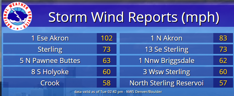
Severe thunderstorms moved through northeast Colorado through late evening on June 8, producing 1 inch hail in Sterling at 10:50 pm EDT June 8 (0450 UTC June 9), as it moved north. The storm went on to produce a wind gust of 61 mph at the Sydney, NE airport 50 minutes later.
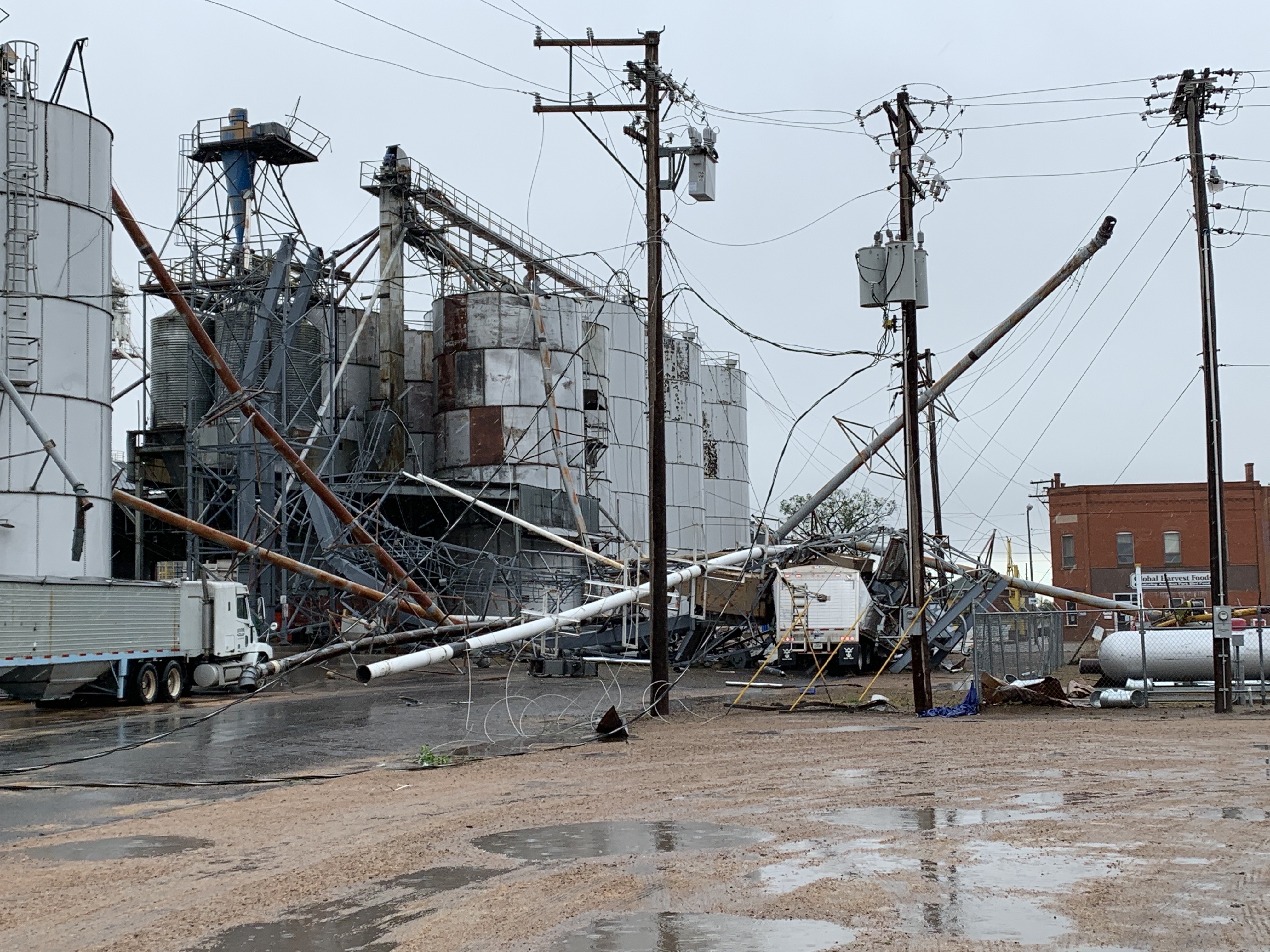
Another thunderstorm strengthened along the Adams/Washington county line at 11:30 pm EDT (0530 UTC June 9) as it moved north, however no damage or wind reports were received as it tracked into southeast Morgan County. This storm began to grow eastward as it tracked north, and the eastern extent of the storm reached Akron shortly after midnight (06 UTC June 9). A wind gust of 83 mph was measured at the Akron airport at 12:11 am (0611 UTC), and a USDA Agriculture Research Station four miles east of Akron measured a 113 mph wind speed.
The storm continued to develop along its eastern edge as it lifted north, creating a southwest to northeast oriented damage pattern. It eventually weakened as it neared the Wyoming border at 1:30 am (0730 UTC).
Damage was consistent with straight line winds, with debris blown to the north and east, outward from the storm path. There were isolated instances of tree damage or roof damage blown toward the south, however this can likely be attributed to the 50 mph surface flow from the north that preceded the storm, and redeveloped after its passage.
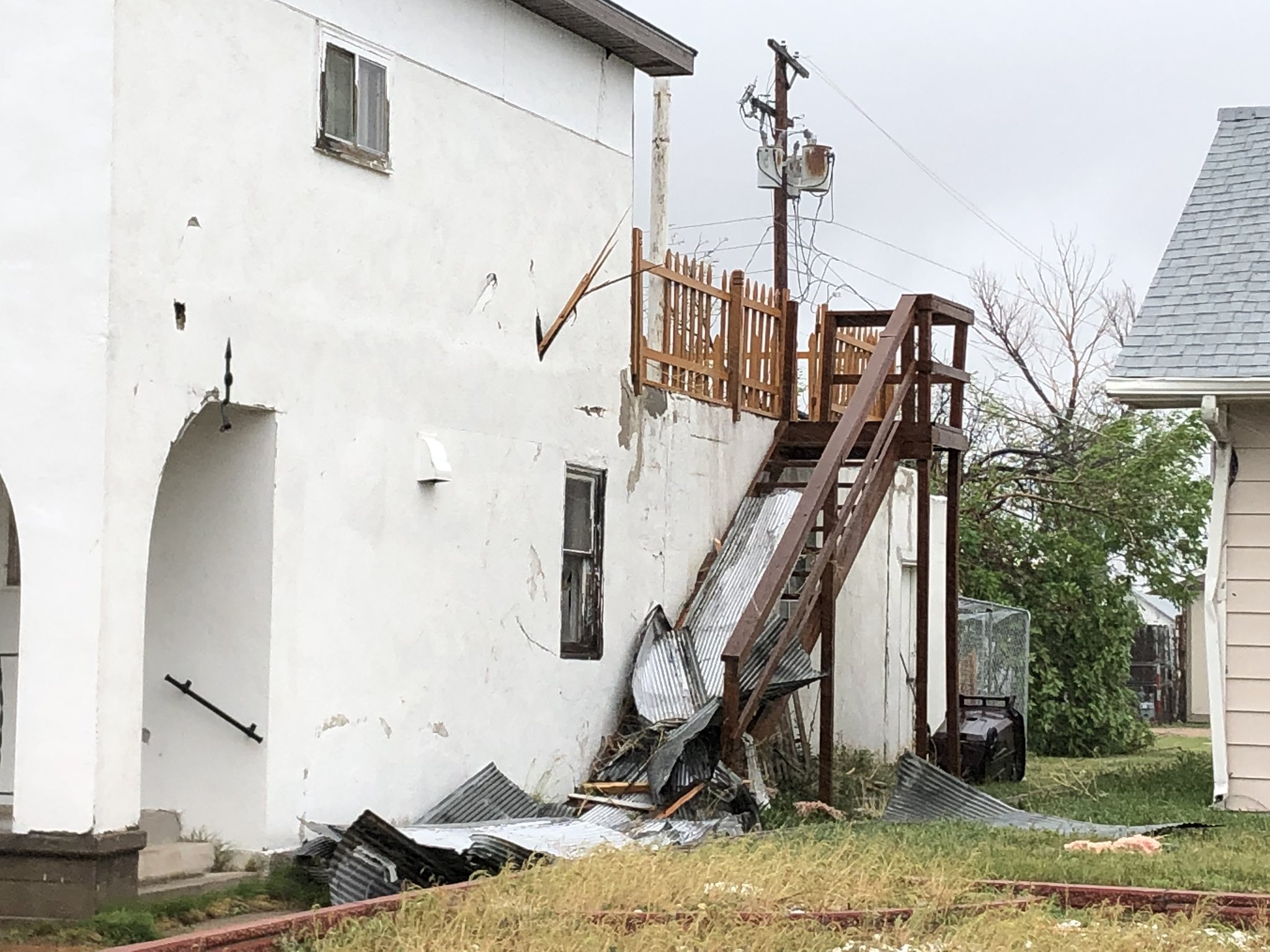
Damage was primarily to trees in more densely populated areas, with damage to a grain elevator equipment and metal roofing and siding removed from commercial buildings. Wind speed estimates based on the observed damage were in the 85 to 100 mph range, and match well with the observed wind speeds. Although EF ratings https://www.weather.gov/oun/efscale are not assigned to straight line winds, the damage and observed winds qualify for an EF0 to EF1.
 |
 |
 |
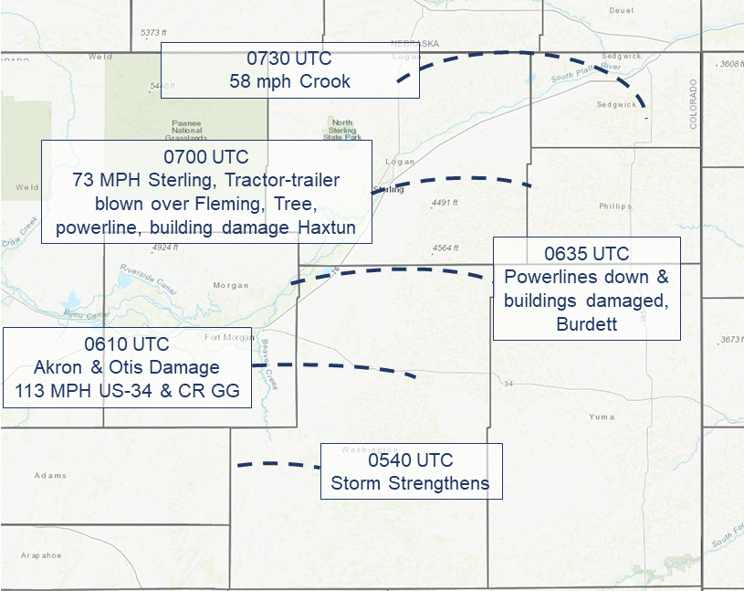 |
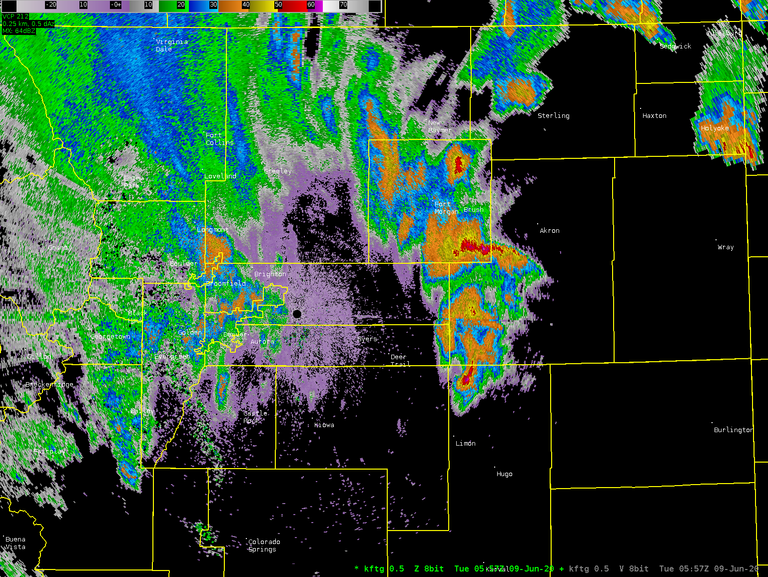
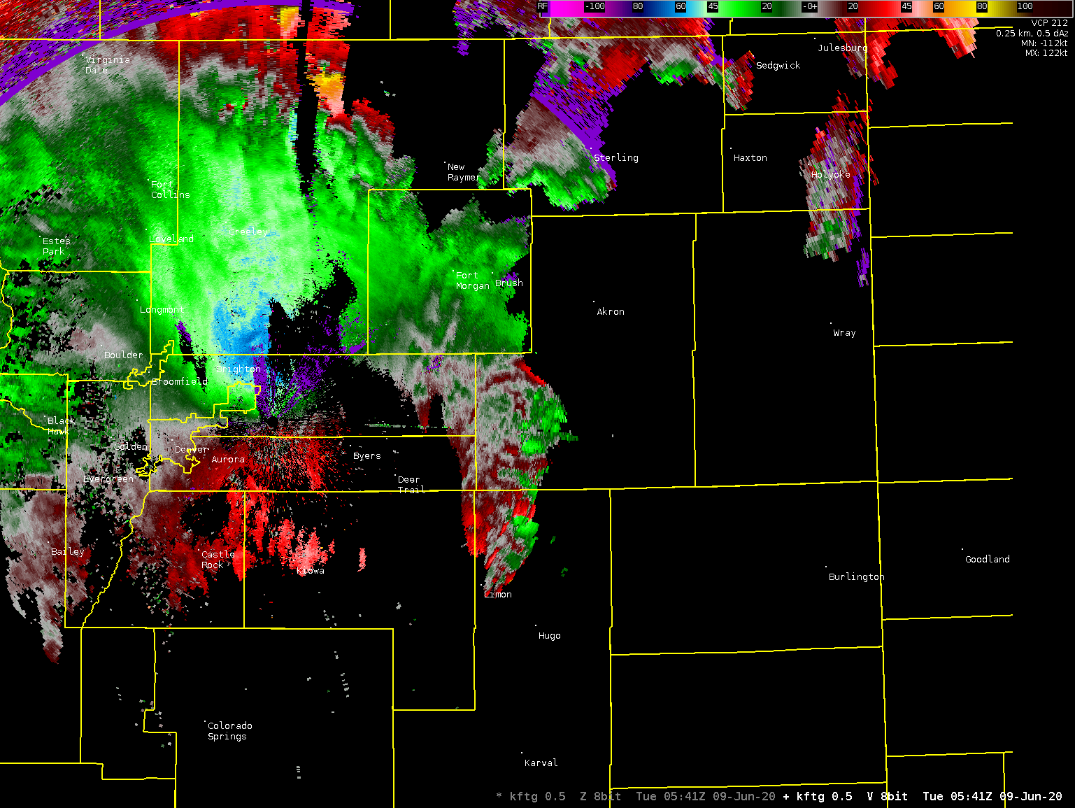
| Thunderstorm Wind Reports 06/08-09/2020 | Radar Loop, 0.5 deg Base Reflectivity, 0600-0730 UTC 06/09/2020 | Radar Loop, 0.5 deg Base Velocity, 0600-0730 UTC 06/09/2020 | June 9 2020 Macroburst Storm Path |
Non-Thunderstorm High Wind
The arrival of the cold front the evening of June 8 brought noticeably colder temperatures for early June, along with strong sustained winds. North winds of 40 to over 50 mph blew from the evening of the 8th through midnight, and then gradually tapered off to 25 to 35 mph through the morning of the 9th.
Highest Wind Gusts, not associated with Thunderstorms, Monday night into Tuesday morning.
| Location | Gust |
| 2 ENE Limon | 71 MPH |
| Limon | 70 MPH |
| Akron | 68 MPH |
| 2 ENE Limon | 67 MPH |
| Fort Morgan Airport | 64 MPH |
| 4 NNW Pawnee Buttes | 64 MPH |
| Briggsdale | 64 MPH |
| Keenesburg | 64 MPH |
| 1 NW Briggsdale | 62 MPH |
| Fort Morgan | 61 MPH |
| 1 ENE Limon | 60 MPH |
| 8 S Holyoke | 60 MPH |
| Strasburg | 60 MPH |
| 1 SE Strasburg | 60 MPH |
| 5 N Pawnee Pass | 60 MPH |
| Sterling | 59 MPH |
| 3 WSW Sterling | 59 MPH |
| Denver Arapahoe | 59 MPH |
| 2 SSE Denver Intl Airport | 58 MPH |
| Hugo | 58 MPH |
| 7 SSW Hugo | 58 MPH |
| Sterling | 58 MPH |
| Wiggins | 58 MPH |
Snow/Ice
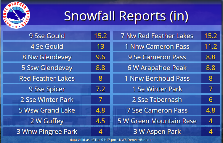
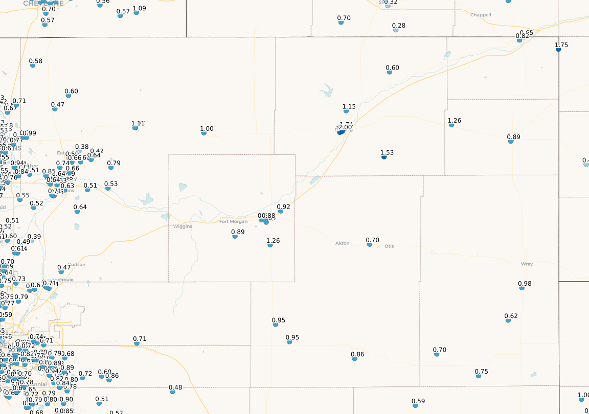
Aside from the severe thunderstorms, the synoptic scale storm system produced widespread precipitation. The combination of the cold pool aloft, ascent from the jet dynamics, and mid-tropospheric overrunning of warm air over cold produced ½ to 1 inch of precipitation. In the higher terrain, where temperatures were cold enough to support snow, up to 15 inches of snow fell.
 |
 |
| Figure 1: Snowfall reports 6/8-9/2020 |
Figure 2: Precipitation Reports 6/8-9/2020 Source: CoCoRaHS.org |
Environment
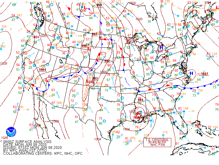
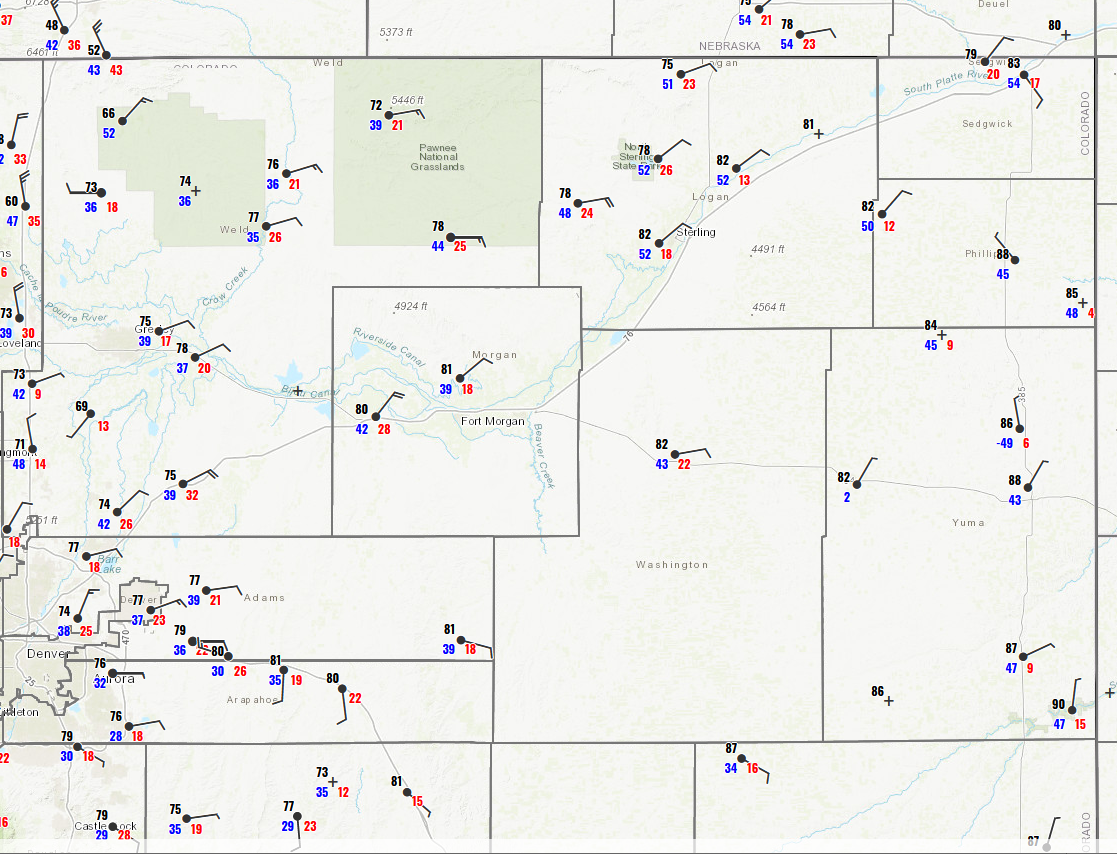
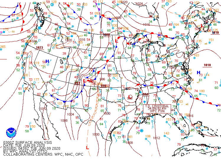
A cold front moved through northeast Colorado late evening on June 7 (Figure 1), bringing north winds across the region. Despite the northerly winds, temperatures on June 8 rose into the 80s (Figure 2). On June 8, around 7 pm to 8 pm (01UTC-02UTC) a second reinforcing cold front arrived (Figure 3), increasing winds to 30 to 40 mph with gusts over 50 mph, and temperatures falling from the low 80s at 6 pm (00 UTC June 9, Figure 1) to the upper 40s and low 50s by 10 pm (04 UTC June 9, Figure 4), with winds up to 50 mph which remained through midnight (06 UTC 06/09, Figure 5). This wedge of cold air at the surface would provide a source of lift for the late-night thunderstorms.
 |
 |
 |
| Figure 1: Surface Analysis 06 UTC 06/08/2020 | Figure 2: Surface Plot 00 UTC 06/09/2020. Current Temperature (Black, F) Dewpoint (Blue, F) Wind Gust (Red, MPH) | Figure 3: Surface Analysis 03 UTC 06/09/2020 |
 |
|
|
|
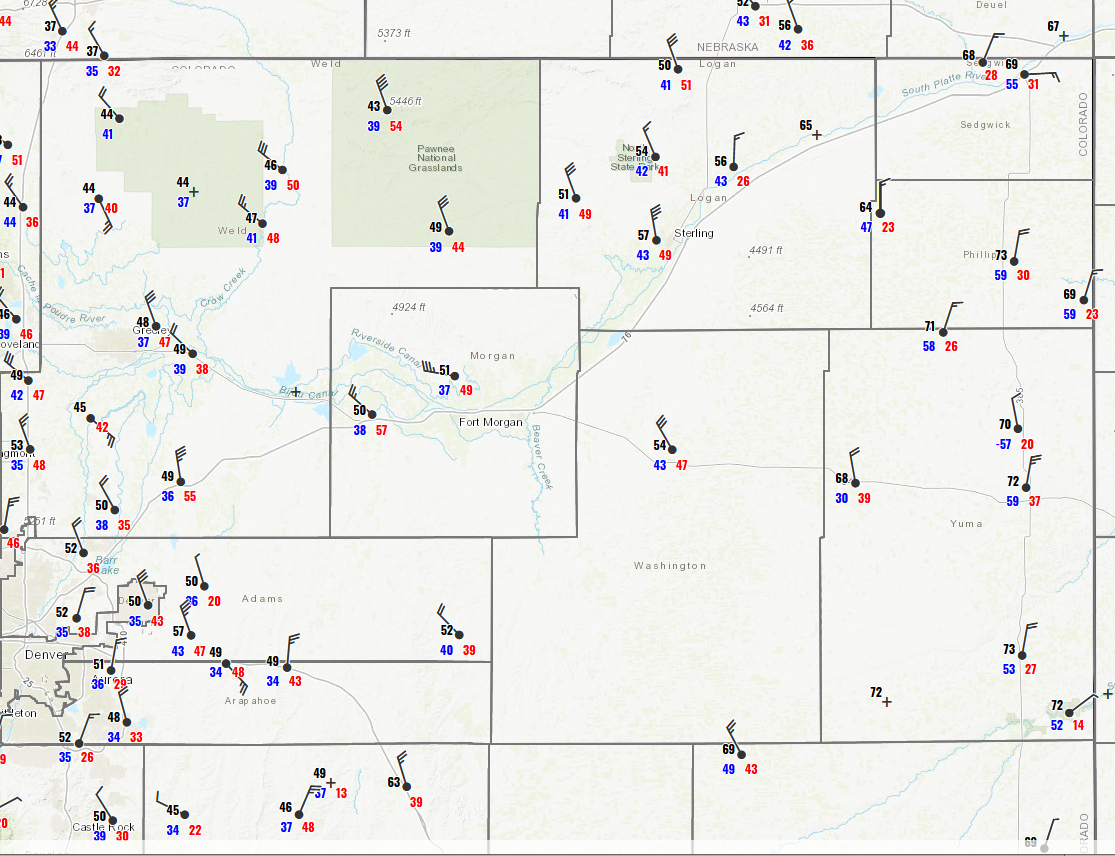
Figure 4: Surface Plot 04 UTC 06/09/2020 Current Temperature (Black, F) Dewpoint (Blue, F) Wind Gust (Red, MPH) |
Figure 5: Surface Plot 06 UTC 06/09/2020. Current Temperature (Black, F) Dewpoint (Blue, F) Wind Gust (Red, MPH) |
Above the cold air at the surface, unstable air remained. High Resolution Rapid Refresh (HRRR) model soundings valid at 1 am (07 UTC, Figure 6) on June 9 showed Convectively Available Potential Energy (CAPE) around 700 J/Kg above 650 MB, or approximately 2 km above the surface. This allowed for elevated thunderstorms to develop above the cold surface air, and travel from south to north in the upper level steering flow.
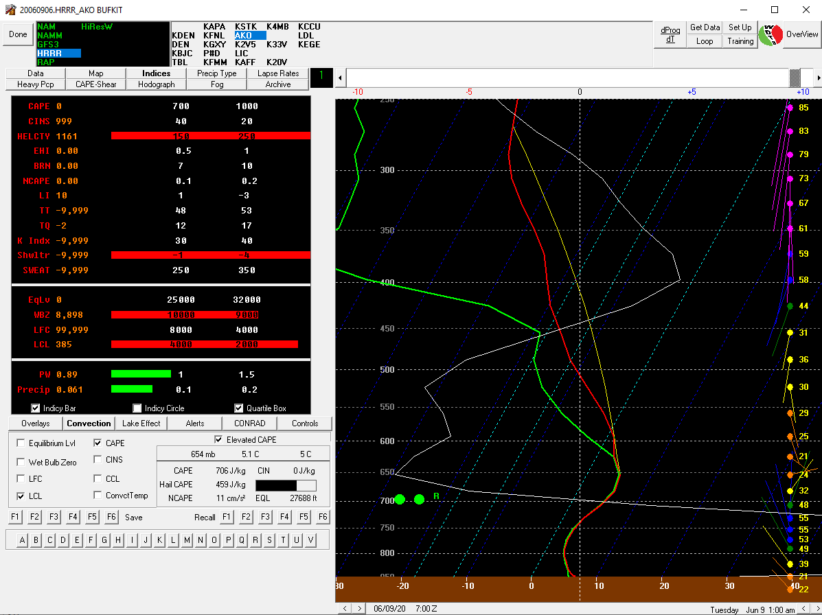 |
| Figure 6: HRRR Forecast Sounding Valid 07 UTC 06/09/2020 |
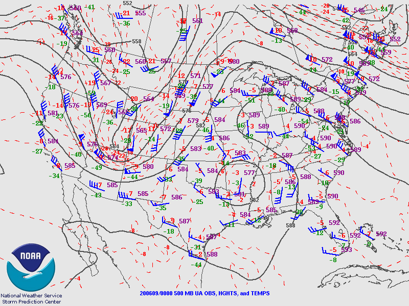
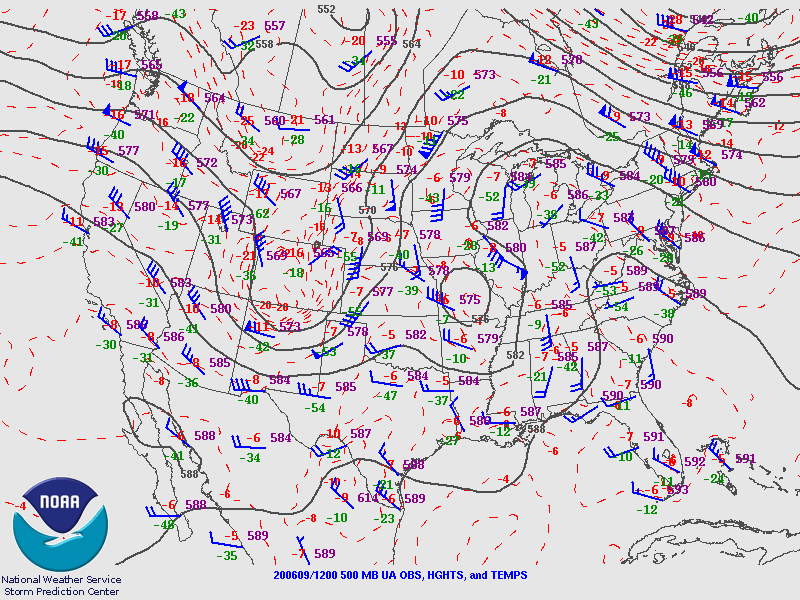
Meanwhile, a larger synoptic weather event unfolded across Colorado, bringing precipitation in the form of snow to the mountains and rain on the plains. A 500 MB longwave trough was entering western Colorado at 6 pm June 8 (00 UTC June 9, Figure 7), and moved to central Colorado by 6 am (12 UTC, Figure 8). A cold pool of -20C accompanied the trough, increasing lapse rates. At 300 MB northern Colorado was located in the right entry region of a 100 KT jet at 6 pm June 8 (00 UTC June 9, Figure 9), a source of large scale ascent.
 |
 |
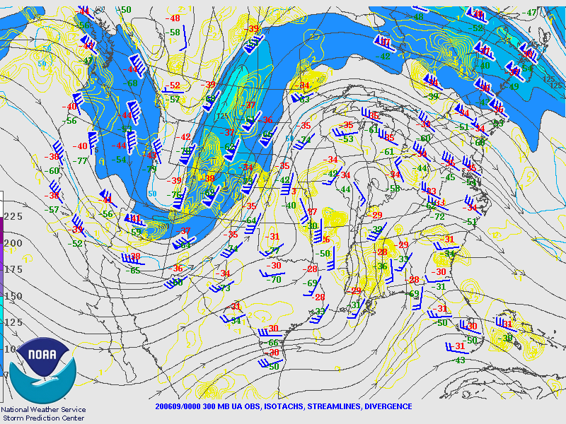 |
| Figure 7: 500 MB Analysis 00 UTC 06/09/2020 | Figure 8: 500 MB Analysis 12 UTC 06/09/2020 | Figure 9: 300 MB Analysis 00 UTC 06/09/2020 |
Photos & Video
 |
 |
 |
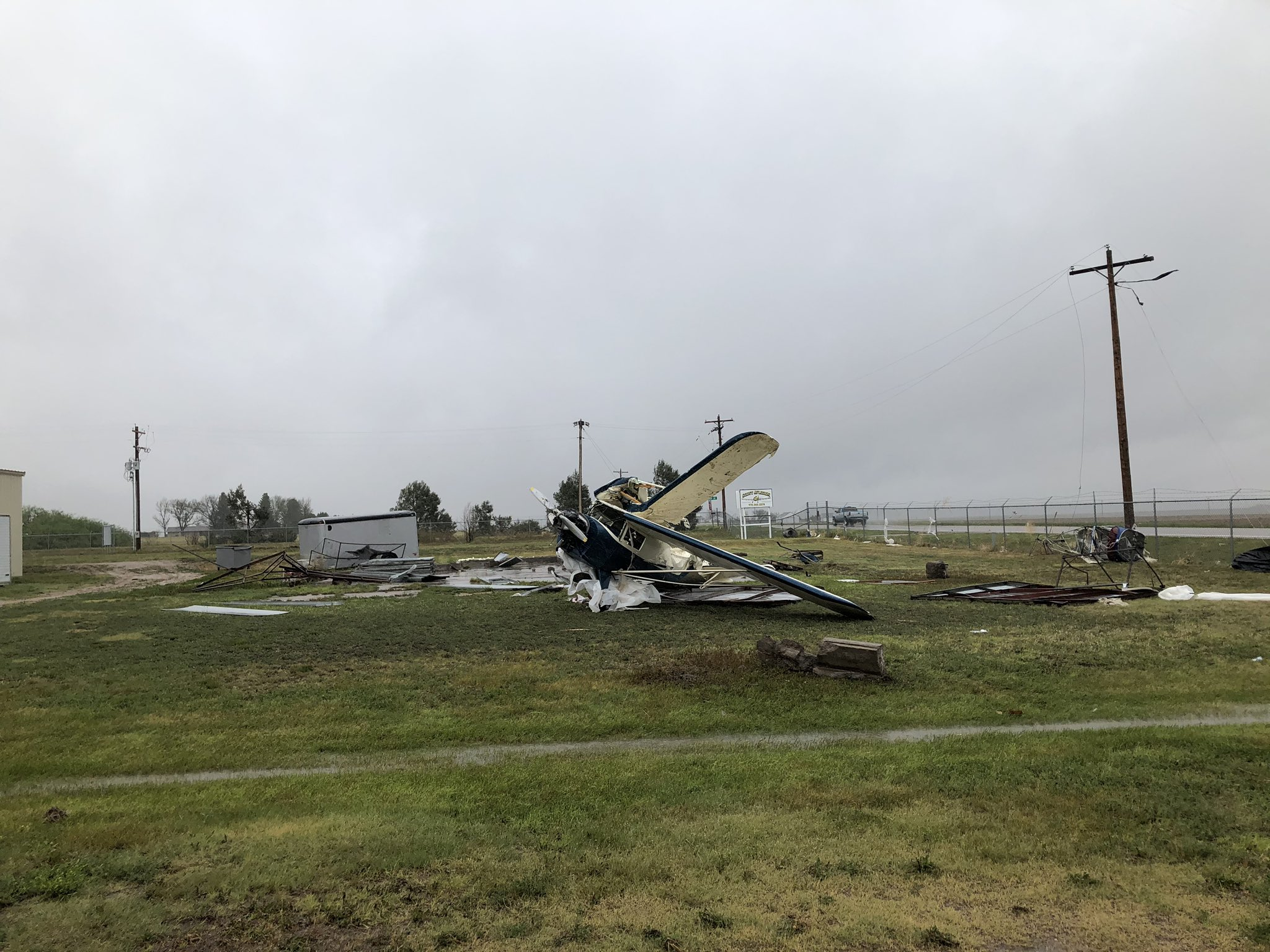 |
| Akron Co Courthouse June 9 2020. View SSE | Grain bin destroyed in Akron CO June 9 2020 | Grain elevator equipment blown onto semi Akron CO June 9 2020 | Airplane destroyed by storm, Akron CO airport June 9 2020 |
 |
 |
 |
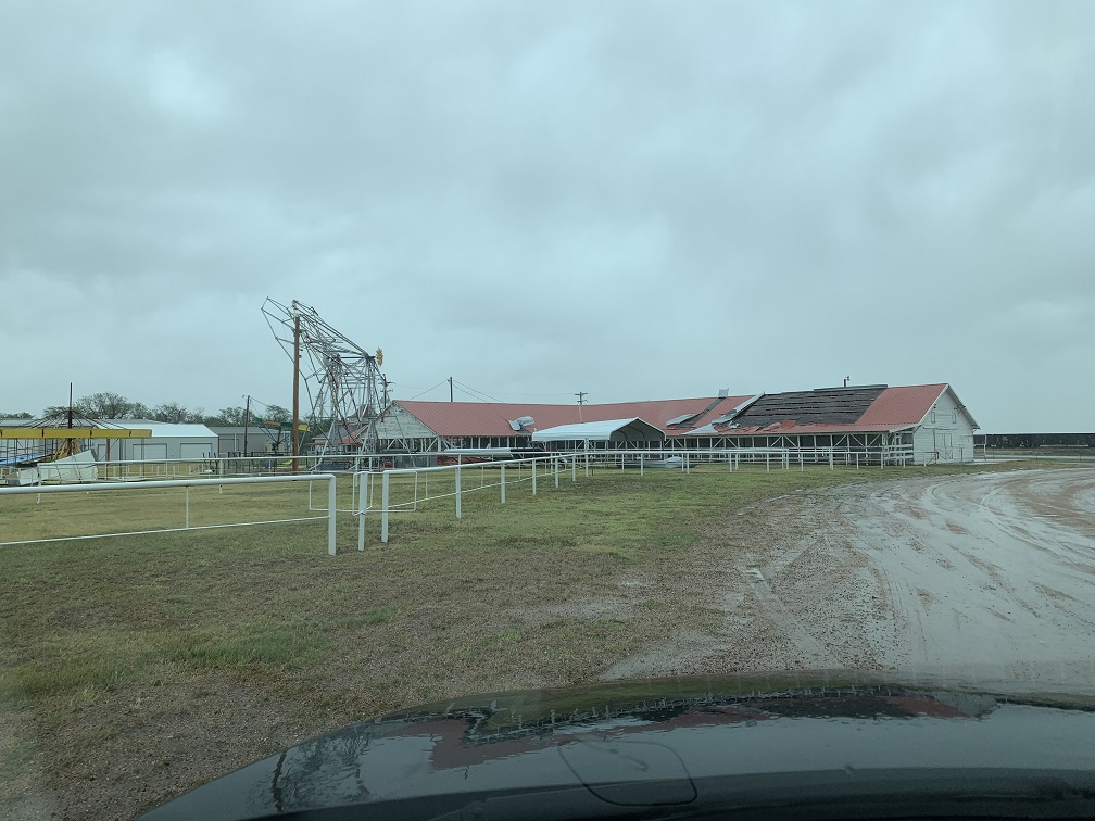 |
| Board blown through house south wall, Akron CO | Metal building de-roofed, Akron CO June 9 2020 | Tree blown down, Akron CO June 9 2020 | Akron Fairgrounds, note damaged Ferris Wheel to left, June 9 2020 |
 |
Media use of NWS Web News Stories is encouraged! Please acknowledge the NWS as the source of any news information accessed from this site. |
|

