
Flash flooding threatens areas from the Tennessee Valley to the Carolinas as storms repeat along a stalled front. Monsoonal storms may trigger flooding in the Southwest. Dangerous heat expands across the Desert Southwest, Plains, mid-Mississippi Valley and Southern Tier. Critical fire weather for interior Pacific Northwest. Cooler, drier air brings brief relief to the Great Lakes and Northeast. Read More >
| 72 Hour Snow Amount Potential
Experimental - Leave feedback
|
|
| Expected 72 Hour Snowfall - Official NWS Forecast
What's this? |
High End 72 Hour Amount 1 in 10 Chance (10%) of Higher Snowfall What's this? |
| Low End 72 Hour Amount 9 in 10 Chance (90%) of Higher Snowfall What's this? |
|
| Percent Chance That 72 Hour Snow Amounts in Will Be Greater Than...
Experimental - Leave feedback
What's this?
|
||||||||||||||||
|
||||||||||||||||
| 72 Hour Snowfall Totals by Location
Experimental - Leave feedback
What's this?
|
|
|
| 72 Hour Ice Accumulation Potential
Experimental - Leave feedback
|
|
| Expected 72 Hour Ice Accumulation - Official NWS Forecast
What's this? This is the elevated flat surface ice accumulation. It is not radial/line ice. Radial/line ice is typically 39% of the elevated flat surface ice. For more information on this, see this module. |
High End 72 Hour Amount 1 in 10 Chance (10%) of Higher Ice Accumulation What's this? |
| Low End 72 Hour Amount 9 in 10 Chance (90%) of Higher Ice Accumulation What's this? |
|
| Percent Chance That 72 Hour Ice Accumulation Will Be Greater Than...
Experimental - Leave feedback
What's this?
|
||||||||||||||||
|
||||||||||||||||
| 72 Hour Ice Accumulation by Location
Experimental - Leave feedback
What's this?
|
|
|
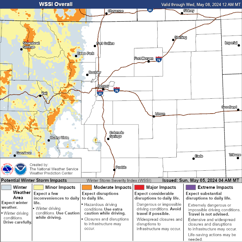
| Winter Storm Severity Index (WSSI) | Winter Storm Outlook (WSO) |
|---|---|
 |
 |
| National Snow Reports | National Snowfall Analysis |
|---|---|
 |
 |
| National Ice Reports | Local Snow Reports |
|
|
|
| Days 4-7 Winter Weather Outlook | |
| Day 4 Winter Weather Outlook | Day 5 Winter Weather Outlook |
 |
 |
| Day 6 Winter Weather Outlook | Day 7 Winter Weather Outlook |
 |
 |
|
|
|
| CPC Week-2 Experimental Heavy Snow Risk | |
 |
|
| CPC Temperature & Precipitation Maps | |
|
Days 6-10 |
|
| Temperature | Precipitation |
 |
 |
|
Days 8-14 |
|
| TEMPERATURE | PRECIPITATION |
 |
 |
|
Week 3-4 |
|
|
TEMPERATURE |
PRECIPITATION |
 |
 |
| Snow Amount Potential
Experimental - Leave feedback
|
|
| Expected 72 Hour Snowfall - Official NWS Forecast
What's this? |
High End 72 Hour Amount 1 in 10 Chance (10%) of Higher Snowfall What's this? |
| Low End 72 Hour Amount 9 in 10 Chance (90%) of Higher Snowfall What's this? |
|
| Percent Chance That 72 Hour Snow Amounts Will Be Greater Than...
Experimental - Leave feedback
What's this?
|
||||||||||||||||
|
||||||||||||||||
| 72 Hour Ice Accumulation Potential
Experimental - Leave feedback
|
|
| Expected 72 Hour Ice Accumulation - Official NWS Forecast
What's this? This is the elevated flat surface ice accumulation. It is not radial/line ice. Radial/line ice is typically 39% of the elevated flat surface ice. For more information on this, see this module. |
High End 72 Hour Amount 1 in 10 Chance (10%) of Higher Ice Accumulation What's this? |
| Low End 72 Hour Amount 9 in 10 Chance (90%) of Higher Ice Accumulation What's this? |
|
| Percent Chance That 72 Hour Ice Accumulations Will Be Greater Than...
Experimental - Leave feedback
What's this?
|
||||||||||||||||
|
||||||||||||||||
| Snow Character (Wet/Dry)
Prototype: These tools are NOT operationally supported.
What's this?
|
 |
| Snow Rate
Prototype: These tools are NOT operationally supported.
What's this?
|
 |
| Selected City Charts | |
Expected Snowfall - Box and Whisker Plot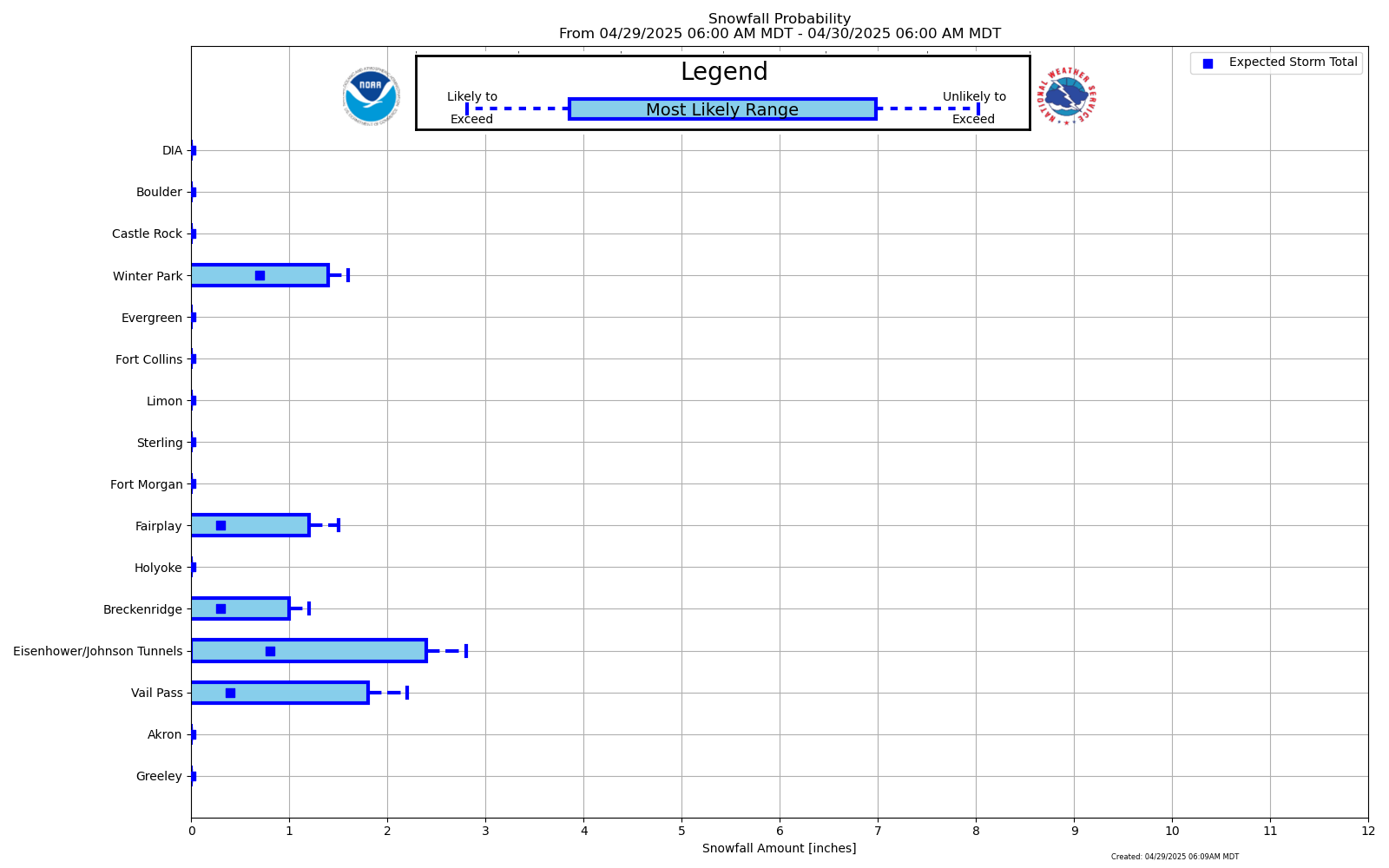 |
Expected Snowfall - Exceedance Bar Plot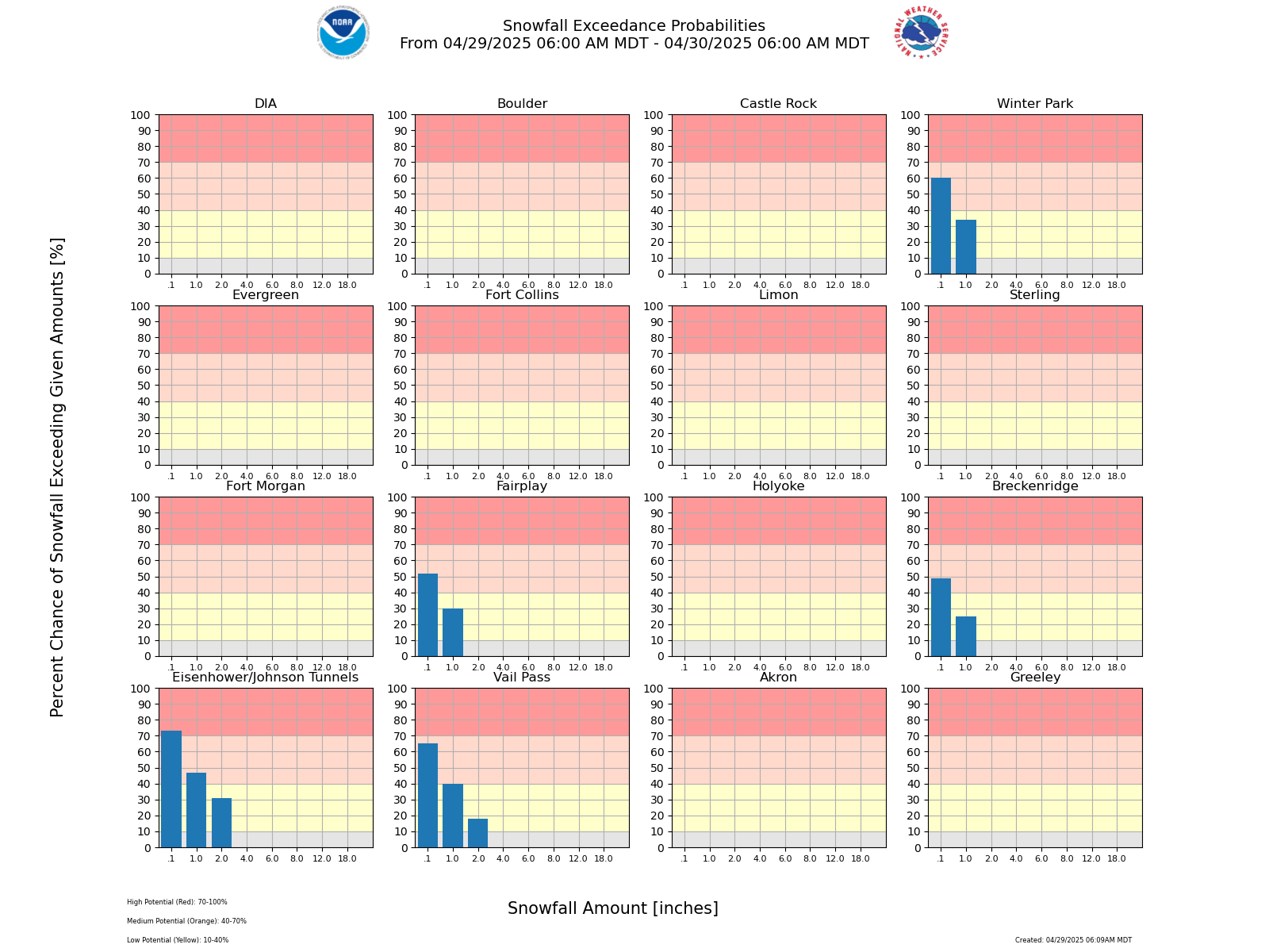 |

