
Scattered thunderstorms with severe gusts, hail and a tornado risk are possible near a cold front from the Ohio Valley to the Mid-Atlantic tonight. Tropical Storm Bertha is expected to bring tropical storm conditions to portions of the Gulf Coast from the panhandle of Florida into Louisiana through Wednesday. Read More >
Denver/Boulder, CO
Weather Forecast Office
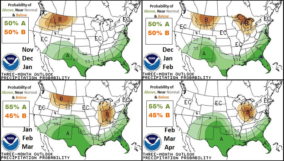
While currently in a Neutral ENSO environment over the Northern Hemisphere, El Nino conditions are expected to develop and strengthen slightly through the winter. What does this mean for Colorado & the high plains region? It means the probability for higher than average precipitation is expected to increase from November through April.
Although the probability outlook does not represent the magnitude of actual precipitation amounts, it does indicate that a more active and unsettled winter pattern is likely to develop through the winter over the southern United States along with the southern & Central Rockies.
Statistically, northeast Colorado receives higher than average precipitation for the winter season during El Nino conditions as deep upslope conditions develop from organized storm systems which track into eastern Colorado & central US plains from the 4-Corner's region of Arizona, New Mexico, Utah and Colorado. Also during El Nino environments, the northern and central mountains receive near to even slightly below average precipitation due to drier and weaker northwest flow aloft. Denver's snowiest month is March.
US Dept of Commerce
National Oceanic and Atmospheric Administration
National Weather Service
Denver/Boulder, CO
325 Broadway
Boulder, CO 80305-3328
303-494-3210 for a recording call 303-494-4221
Comments? Questions? Please Contact Us.

