Dangerous heat will expand from the Gulf Coast into the Southern Plains and Desert Southwest through week's end. Additional extreme heat impacting the Pacific Northwest will shift to the northern Plains by the weekend. Tropical Storm Bertha is expected to continue to impact portions of the northern Gulf Coast from the western Florida Panhandle to southeastern Louisiana through tonight. Read More >
Overview
|
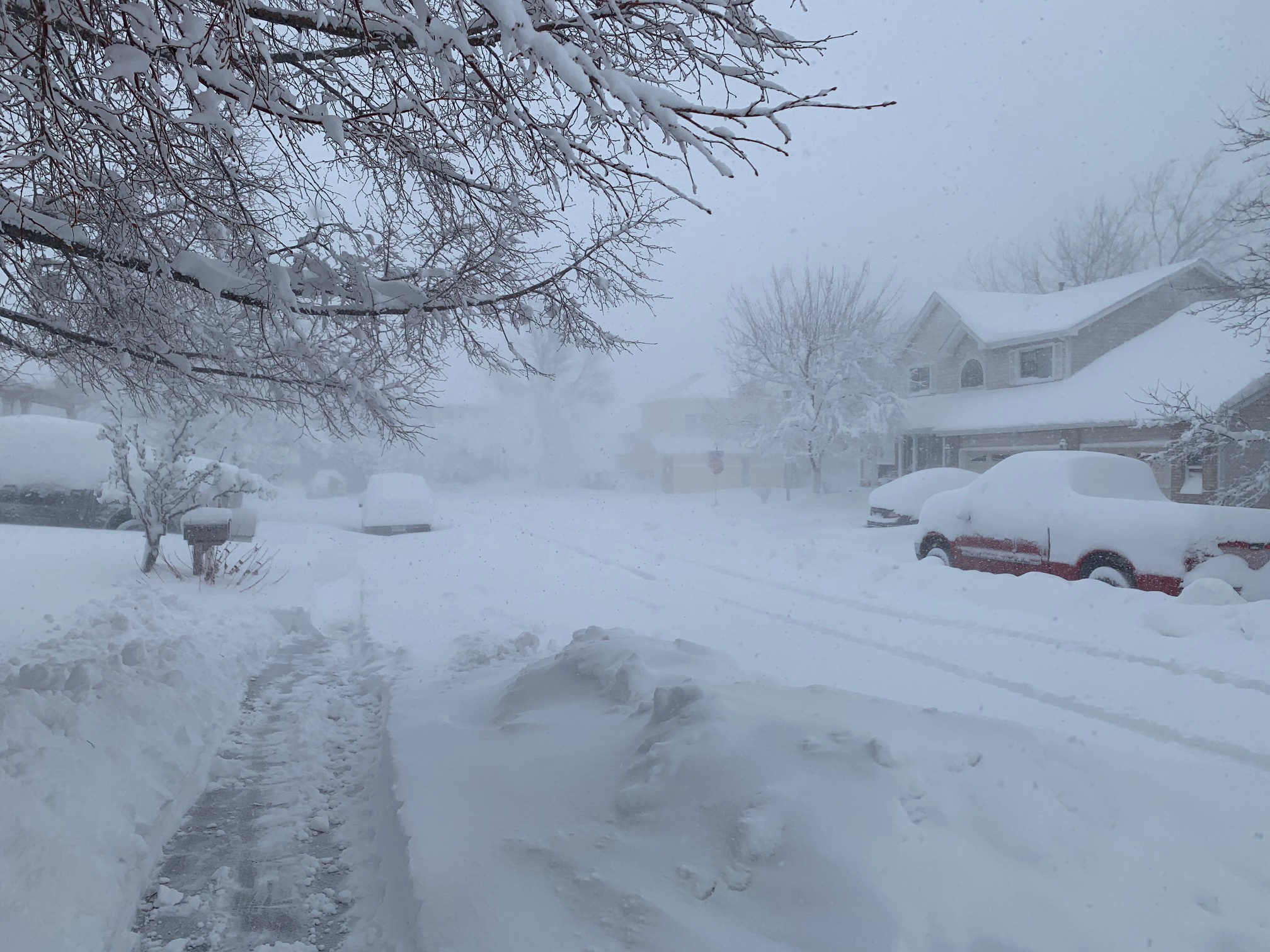
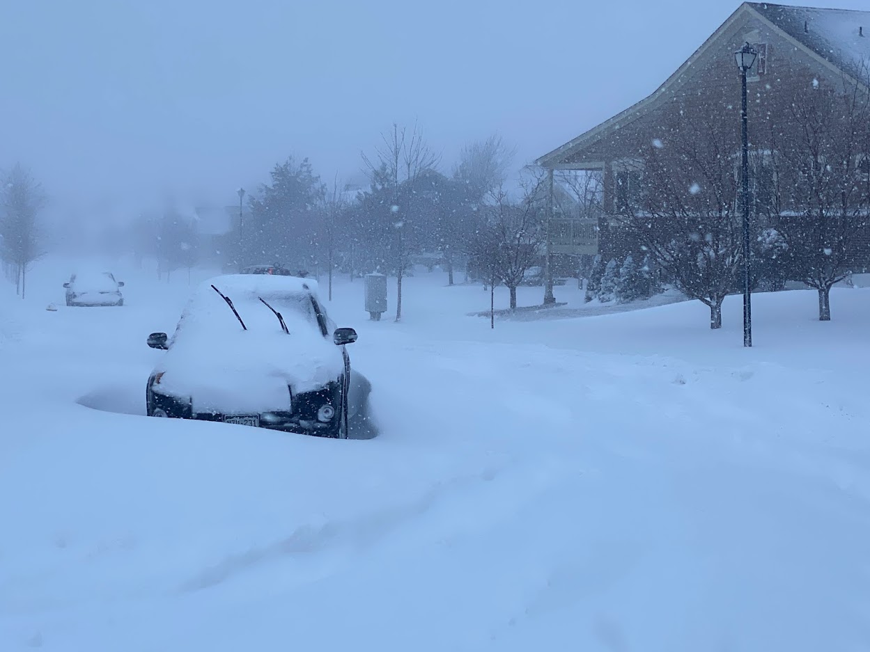
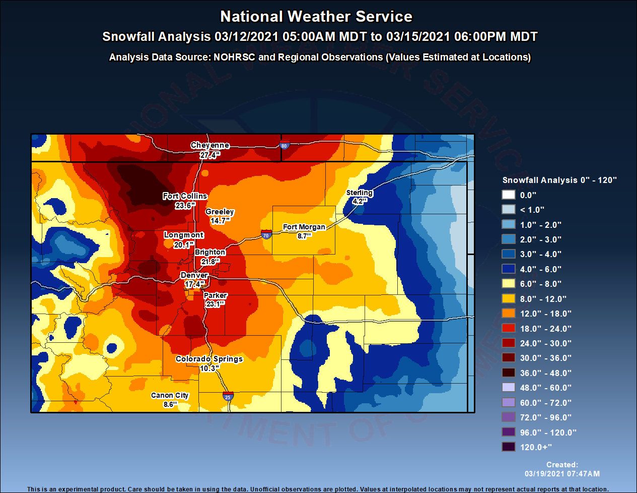
A significant blizzard struck northeast Colorado March 13th and 14th, 2021. A deep storm system over the Desert Southwest tracked to the Four Corners area on Saturday, March 13, and then east/northeast across southern Colorado and into east central Colorado on Sunday, March 14. This is a very favorable track for significant winter storms for northeast Colorado, the Front Range, and the Denver metropolitan area, and this storm lived up to its full potential. Areas of snow (rain on the eastern plains) developed ahead of the storm system and spread northward across Colorado Saturday. By Saturday night, the focus for the heaviest snow had shifted to the northern border area, with areas around Fort Collins and the northern Front Range Foothills receiving the heaviest snow. By early Sunday morning, between 10 and 17 inches of snow was already reported in the Fort Collins and Wellington areas, with around two feet in the foothills of Larimer County. The heavy, wet snow had accumulated on trees and powerlines, producing scattered power outages. Meanwhile, most of the Denver metro area had received between five and eight inches of snow. However, the heaviest snowfall was yet to come! Early Sunday morning, the heavy snow quickly spread southward across the rest of the I-25 Urban Corridor and Front Range, including the entire Denver metropolitan area. Snow was falling at the rate of one to two inches per hour. Winds also began to increase at this time, with north winds along the I-25 Corridor increasing to 20-30 mph with gusts around 40 mph. Blizzard conditions developed all up and down the Front Range late Sunday morning as winds continued to increase, and the snow became even heavier, falling at the rates of two to three inches per hour. Peak wind gusts recorded in the afternoon included; 48 mph at Denver International Airport, 49 mph at Centennial and Fort Collins/Loveland Regional Airports, and as high as 66 mph along I-25 north of Wellington, Colorado. Travel became nearly impossible due to the significant snow accumulations, blowing snow, deep drifting, and without conditions. Snow drifts reached a depth of three to seven feet. All major interstates were closed except for those areas immediately in/near Denver and Fort Collins. Denver International Airport runways were closed from noon Sunday until 2 pm on Monday, with over 2,000 flights canceled. The snow decreased from west to east across the plains Sunday evening, finally ending over the northeastern plains Monday morning. Snowfall totals by the end of this significant blizzard ranged from 18 to 30 inches across the I-25 Corridor, with 20 to 40 inches in the Front Range Mountains and Foothills. Local amounts up to four feet were reported in the northern foothills and mountains of Larimer county. The official snowfall for Denver was 27.1 inches, which was the fourth largest storm on record since 1882. |
This image taken from Fort Collins. Photo courtesy of Eric Jensen. |
Photos & Video
Header
 |
 |
 |
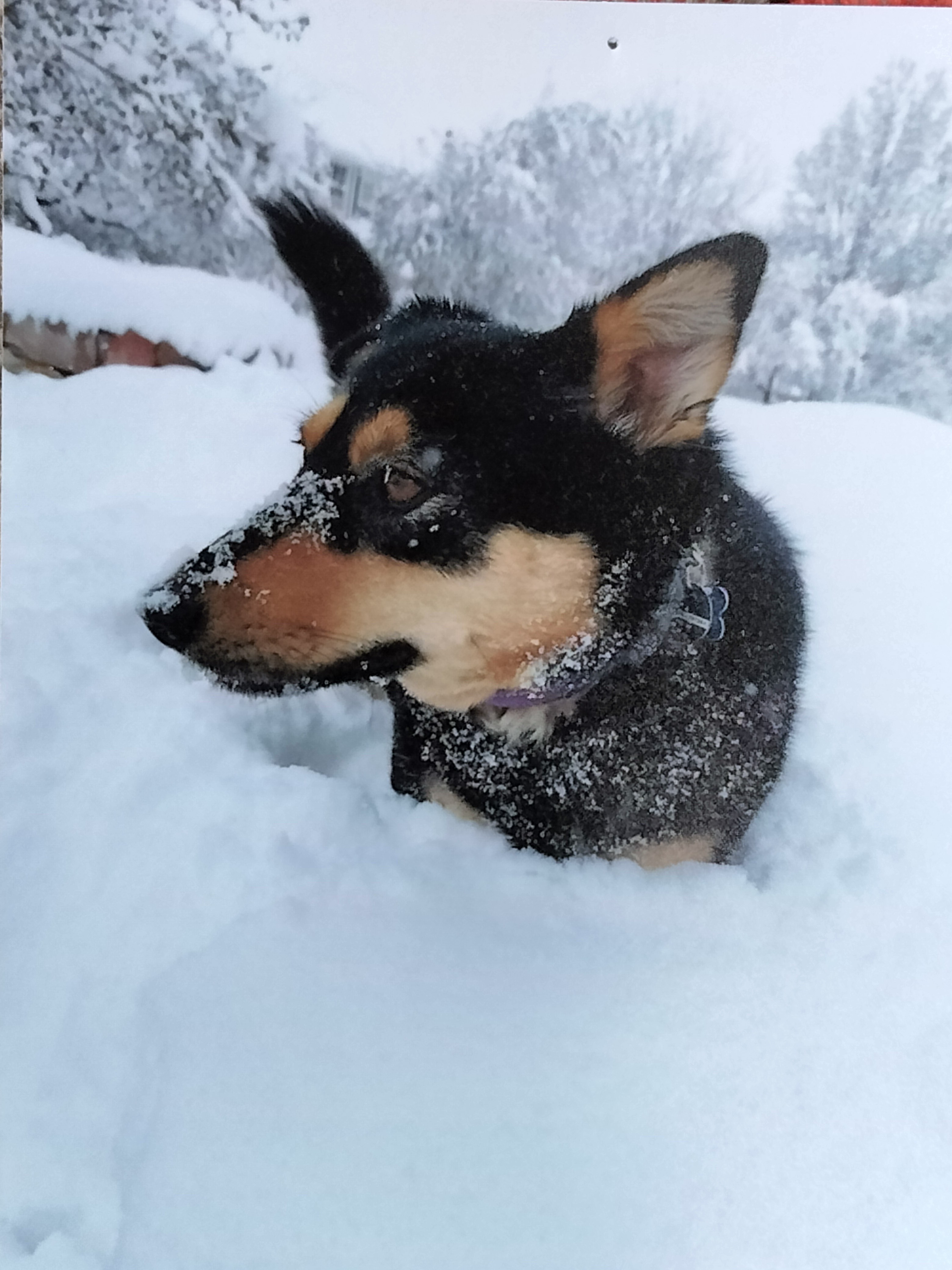 |
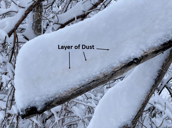
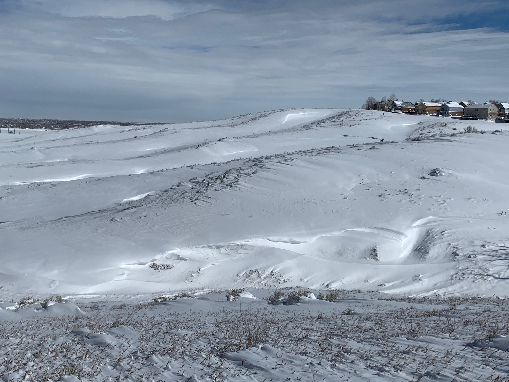
| Heavy snow and stuck cars in Arvada | Stacked snow in Boulder, showing a layer of dust that originated from Mexico | Drifted snow in Broomfield Open Space | A dog's life, enjoying the snow in rural Boulder County |
Radar & Satellite
Header
 |
 |
 |
.gif) |
| Radar loop of the first wave of rain and snow Saturday, March 13, 2021 | Radar loop for Saturday night, showing the heaviest snow taking direct aim on Fort Collins and southern Wyoming | Sunday, March 14th, Radar Loop. Heavy snow fell most of the day in/near the Colorado Front Range | Satellite loop on March 14th showing the full scope of this powerful winter storm |
Storm Reports
Summary of Snowfall Reports
Location                     Amount    Time/Date       Lat/Lon

...Colorado...

...Adams County...
1 ENE Brighton               25.9 in   0916 AM 03/15   39.99N/104.78W
2 NE Thornton                20.6 in   0607 AM 03/15   39.92N/104.93W
1 WNW Northglenn             20.2 in   0700 AM 03/15   39.91N/105.00W
2 NE Northglenn              18.2 in   0700 AM 03/15   39.92N/104.96W
2 WSW Northglenn             18.0 in   0700 AM 03/15   39.90N/105.01W
4 NNW Aurora                 17.0 in   0700 AM 03/15   39.76N/104.84W
2 NW Todd Creek              17.0 in   0700 AM 03/15   40.00N/104.91W

...Arapahoe County...
2 N Highlands Ranch          30.5 in   0700 AM 03/15   39.58N/104.97W
2 ESE Buckley AFB            28.0 in   0700 AM 03/15   39.69N/104.71W
3 E Cherry Creek Reservoir   26.0 in   1236 AM 03/15   39.64N/104.82W
Aurora                       25.0 in   0547 AM 03/15   39.70N/104.81W
3 SSE Arapahoe Park          24.0 in   0700 AM 03/15   39.59N/104.67W
1 NNW Englewood              24.0 in   0344 AM 03/15   39.66N/105.00W
2 ENE Highlands Ranch        22.0 in   0700 AM 03/15   39.57N/104.93W
3 N Foxfield                 18.0 in   0700 AM 03/15   39.63N/104.80W
2 N Lone Tree                17.5 in   1232 AM 03/15   39.57N/104.89W
2 NNE Foxfield               16.3 in   0844 AM 03/15   39.62N/104.78W
2 SW Cherry Hills Village    14.8 in   0944 AM 03/15   39.62N/104.97W
4 S Bennett                  14.8 in   0900 AM 03/15   39.70N/104.41W
2 WSW Byers                  10.0 in   0700 AM 03/15   39.70N/104.26W

...Boulder County...
3 NNE Pinecliffe             30.0 in   0700 AM 03/15   39.97N/105.40W
3 S Raymond                  28.6 in   1254 AM 03/15   40.11N/105.44W
3 W Jamestown                28.6 in   1209 AM 03/15   40.11N/105.44W
Nederland                    25.9 in   0700 AM 03/15   39.97N/105.51W
2 WSW Louisville             25.6 in   0840 AM 03/15   39.96N/105.18W
3 NE Longmont                25.5 in   0800 AM 03/15   40.20N/105.08W
2 NE Longmont                24.9 in   0700 AM 03/15   40.19N/105.09W
2 WNW Erie                   24.0 in   1214 PM 03/15   40.04N/105.07W
1 WNW Eldorado Springs       23.0 in   0700 AM 03/15   39.94N/105.28W
Louisville                   22.0 in   1210 PM 03/15   39.97N/105.14W
1 SSW Lafayette              21.0 in   0734 AM 03/15   39.98N/105.11W
3 SSW Boulder                20.7 in   0825 AM 03/15   39.99N/105.27W
2 NNW Erie                   20.0 in   0912 AM 03/15   40.06N/105.06W
3 SSE Hygiene                20.0 in   0730 AM 03/15   40.14N/105.15W
2 N Longmont                 19.0 in   0613 AM 03/15   40.20N/105.11W
1 NNE Lafayette              16.0 in   0700 AM 03/15   40.01N/105.09W
1 NNW Hygiene                15.5 in   0700 AM 03/15   40.20N/105.18W
1 W Boulder                  15.0 in   0700 AM 03/15   40.03N/105.28W
5 E Jamestown                9.0 in    0700 AM 03/15   40.12N/105.29W

...Broomfield County...
1 NW Broomfield              22.5 in   0800 AM 03/15   39.93N/105.08W

...Clear Creek County...
2 SSE Blue Valley            32.4 in   0700 AM 03/15   39.68N/105.47W
3 SSE Silver Plume           30.0 in   0600 AM 03/15   39.66N/105.71W
2 SSW Brookvale              27.1 in   0700 AM 03/15   39.61N/105.44W
Georgetown                   22.4 in   0800 AM 03/15   39.72N/105.70W

...Denver County...
2 SE Denver Intl Airport     27.1 in   1200 AM 03/15   39.85N/104.66W
2 E Denver                   19.7 in   0854 AM 03/15   39.74N/104.95W
5 SE Commerce City           18.4 in   0600 AM 03/15   39.76N/104.87W
4 ESE Denver                 17.0 in   0745 AM 03/15   39.72N/104.92W
2 ESE Denver                 16.2 in   0746 AM 03/15   39.73N/104.95W

...Douglas County...
2 ENE Parker                 28.4 in   0747 AM 03/15   39.52N/104.73W
3 SE Shamballa               26.0 in   0700 AM 03/15   39.33N/104.96W
3 W Ponderosa Park           25.8 in   0700 AM 03/15   39.39N/104.69W
3 WSW Roxborough Park        24.0 in   0700 AM 03/15   39.43N/105.12W
1 NW Castle Pines            23.0 in   1043 AM 03/15   39.48N/104.90W
2 NNW Roxborough Park        22.8 in   0700 AM 03/15   39.46N/105.09W
3 SSW Castle Pines           20.2 in   0559 AM 03/15   39.43N/104.90W
2 WSW Lone Tree              18.5 in   0659 AM 03/15   39.53N/104.92W
1 N Castle Rock              18.1 in   0800 AM 03/15   39.39N/104.85W
3 SW Highlands Ranch         16.5 in   0748 AM 03/15   39.53N/105.02W
1 NW Lone Tree               16.5 in   0700 AM 03/15   39.55N/104.90W
2 SE Chatfield Reservoir     14.0 in   0630 AM 03/15   39.54N/105.03W

...Elbert County...
9 NNE Kiowa                  25.8 in   0700 AM 03/15   39.46N/104.38W
Elizabeth                    23.5 in   0822 AM 03/15   39.36N/104.60W
1 WNW Ponderosa Park         23.0 in   0731 AM 03/15   39.41N/104.66W
Ponderosa Park               20.6 in   0700 AM 03/15   39.40N/104.64W
2 NE Elizabeth               17.0 in   0700 AM 03/15   39.38N/104.58W
9 NE Ponderosa Park          15.0 in   0800 AM 03/15   39.50N/104.53W
1 SE Agate                   9.0 in    0700 AM 03/15   39.46N/103.94W
10 NE Kutch                  2.0 in    0630 AM 03/15   39.00N/103.74W

...Gilpin County...
1 W Aspen Springs            41.3 in   0850 AM 03/15   39.83N/105.50W
3 NNE Aspen Springs          39.0 in   1019 AM 03/15   39.87N/105.46W
Aspen Springs                32.0 in   0700 AM 03/15   39.83N/105.48W

...Grand County...
1 ENE Winter Park            17.5 in   0800 AM 03/15   39.89N/105.76W
4 SW Grand Lake              8.8 in    0700 AM 03/15   40.21N/105.86W
2 SSW Elkdale                5.7 in    0700 AM 03/15   40.01N/105.89W
9 WNW Kremmling              3.0 in    0700 AM 03/15   40.12N/106.52W
Williams Fork Reservoir      2.0 in    0700 AM 03/15   40.03N/106.20W

...Jackson County...
3 SSE Mt Zirkel              18.0 in   0600 AM 03/15   40.80N/106.64W
1 SE Gould                   8.6 in    0831 AM 03/15   40.51N/106.01W
1 NNE Rabbit Ears Pass       8.0 in    0600 AM 03/15   40.39N/106.60W

...Jefferson County...
3 WNW Arvada                 29.3 in   0800 AM 03/15   39.85N/105.16W
1 SSW Crescent Village       29.0 in   0836 AM 03/15   39.91N/105.34W
2 SSW Rocky Flats            23.0 in   0722 AM 03/15   39.87N/105.23W
2 W Wheat Ridge              22.2 in   0700 AM 03/15   39.77N/105.13W
Arvada                       22.0 in   0400 AM 03/15   39.83N/105.11W
1 ENE Evergreen              20.0 in   0800 AM 03/15   39.64N/105.32W
2 ESE Ken Caryl              20.0 in   1201 AM 03/15   39.57N/105.11W
1 WSW Lakewood               18.0 in   0700 AM 03/15   39.69N/105.13W
1 S Columbine                16.5 in   0900 AM 03/15   39.58N/105.07W
1 NNW Cheesman Reservoir     16.0 in   0730 AM 03/15   39.22N/105.28W
2 ENE White Ranch Open Space 13.0 in   0800 AM 03/15   39.83N/105.24W

...Larimer County...
3 ESE Buckhorn Mountain      48.5 in   0830 AM 03/15   40.60N/105.28W
8 NE Four Corners            42.0 in   0703 AM 03/15   40.94N/105.79W
7 E Pingree Park             41.0 in   0812 AM 03/15   40.58N/105.45W
2 SE Horsetooth Mountain     36.5 in   0700 AM 03/15   40.52N/105.16W
7 SE Cherokee Park           33.0 in   0700 AM 03/15   40.85N/105.40W
4 S Cherokee Park            32.3 in   0700 AM 03/15   40.86N/105.51W
7 ENE Virginia Dale          31.0 in   0835 AM 03/15   40.97N/105.22W
7 W Rustic                   30.0 in   0700 AM 03/15   40.70N/105.71W
2 N Campion                  30.0 in   0700 AM 03/15   40.37N/105.10W
2 WNW Loveland               28.4 in   0401 PM 03/15   40.43N/105.11W
2 S Laporte                  27.9 in   0700 AM 03/15   40.59N/105.13W
1 NNE Estes Park             26.3 in   1100 AM 03/15   40.39N/105.51W
1 NE Glen Haven              24.5 in   0700 AM 03/15   40.47N/105.43W
4 WSW Berthoud               23.5 in   0700 AM 03/15   40.28N/105.16W
4 WSW Drake                  23.0 in   0700 AM 03/15   40.41N/105.41W
2 NW Fort Collins            23.0 in   1151 PM 03/14   40.57N/105.10W
2 S Estes Park               22.7 in   0700 AM 03/15   40.35N/105.52W
1 S Loveland                 17.0 in   0809 AM 03/15   40.40N/105.07W
Berthoud                     17.0 in   0700 AM 03/15   40.30N/105.08W

...Lincoln County...
Hugo                         5.8 in    0700 AM 03/15   39.13N/103.47W
Limon                        4.5 in    0700 AM 03/15   39.27N/103.69W

...Logan County...
1 S Crook                    2.0 in    0700 AM 03/15   40.85N/102.80W
1 SSW Sterling               1.3 in    0837 AM 03/15   40.62N/103.22W
Crook                        1.0 in    0630 AM 03/15   40.86N/102.80W

...Morgan County...
1 ESE Gary                   11.2 in   0600 AM 03/15   40.07N/103.57W
1 SW Fort Morgan             8.0 in    0700 AM 03/15   40.25N/103.81W
1 S Wiggins                  7.0 in    0700 AM 03/15   40.21N/104.08W

...Park County...
3 N 11-Mile Canyon Reservoir 16.5 in   0700 AM 03/15   38.94N/105.49W
1 NW Grant                   10.0 in   0730 AM 03/15   39.46N/105.68W
Antero Reservoir             3.0 in    0714 AM 03/15   38.99N/105.89W

...Summit County...
6 NNW Silverthorne           6.5 in    0700 AM 03/15   39.72N/106.14W
2 SSW Silverthorne           5.1 in    0700 AM 03/15   39.62N/106.10W
Dillon                       5.0 in    0700 AM 03/15   39.63N/106.04W
2 N Heeney                   4.7 in    0700 AM 03/15   39.90N/106.31W
Frisco                       4.6 in    0700 AM 03/15   39.58N/106.10W
1 NW Heeney                  4.5 in    0700 AM 03/15   39.87N/106.31W

...Washington County...
3 SSE Woodlin School         13.0 in   0700 AM 03/15   39.76N/103.50W

...Weld County...
1 W Firestone                25.0 in   1031 AM 03/15   40.12N/104.96W
2 S Johnstown                21.0 in   1053 AM 03/15   40.31N/104.91W
2 NW Frederick               18.0 in   0911 AM 03/15   40.12N/104.96W
1 NNE Erie                   17.6 in   0142 PM 03/15   40.05N/105.03W
1 SSW Carr                   14.8 in   0700 AM 03/15   40.89N/104.88W
1 NW Briggsdale              12.0 in   0800 AM 03/15   40.64N/104.33W
1 WNW Briggsdale             12.0 in   0700 AM 03/15   40.63N/104.33W
Evans                        11.2 in   0700 AM 03/15   40.38N/104.70W
Environment
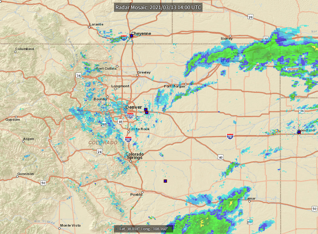
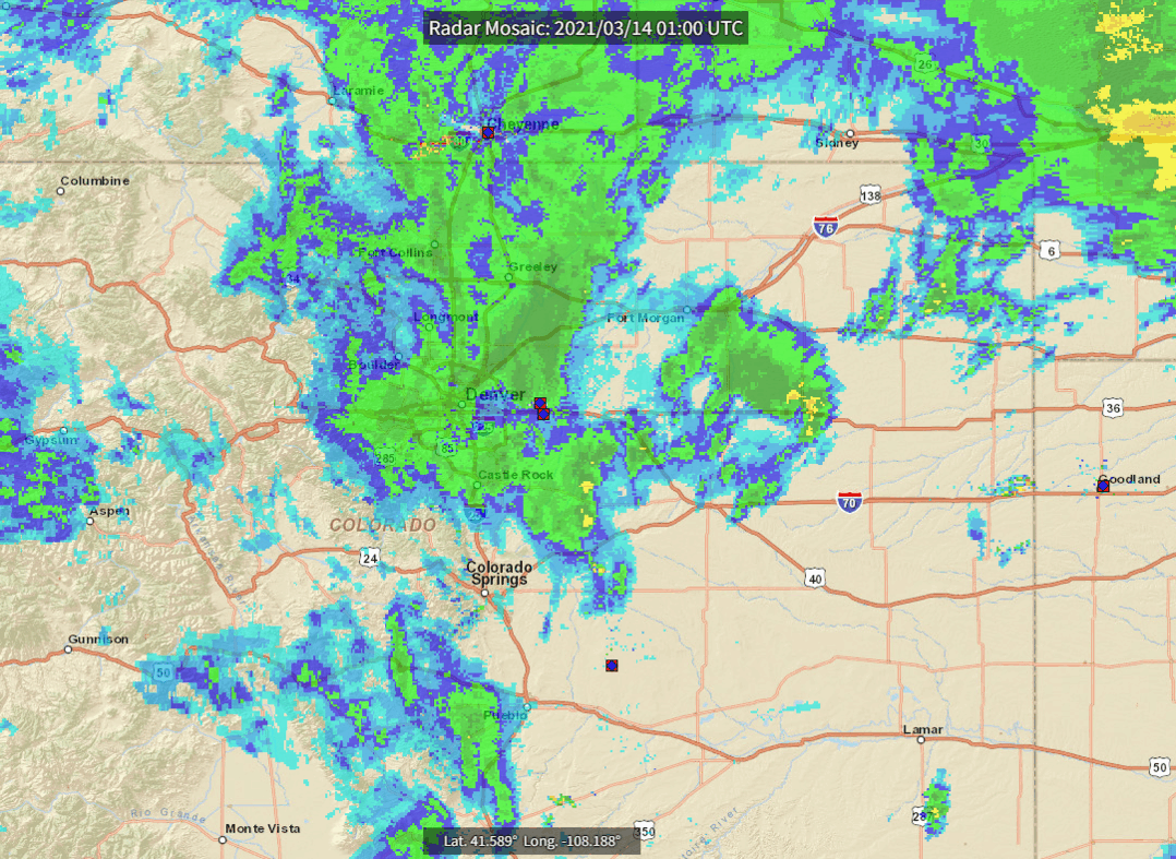
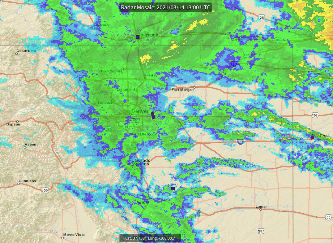
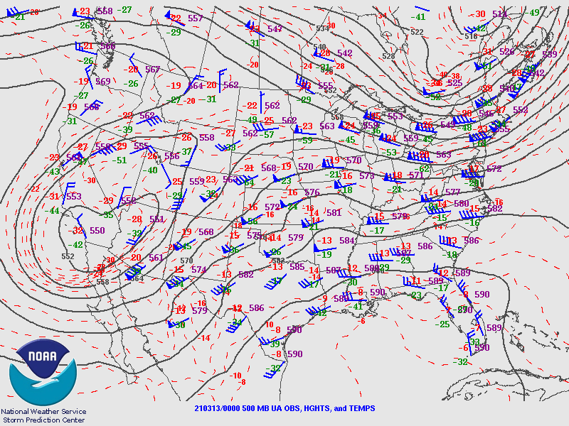
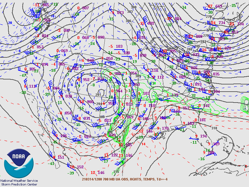
A strong storm system moved into the southwestern United States on March 13th, 2021, and then tracked northeast across the Desert Southwest and into eastern Colorado by March 14th (Figure 1). This is a very favorable track for heavy snowfall and spring-time blizzards in northeast Colorado, and this storm was no exception. Snow, mixed with rain on the plains, began to develop on Saturday March 13th, and then heavy snow fell Saturday night mainly to the north of Denver around Fort Collins and into southern Wyoming. By the morning of the 14th, heavy snow began to spread back to all of the Front Range and I-25 Urban Corridor south through the Denver metro area. This expansion and enhancement occurred as the storm intensified further, and slowed just to the south and southeast of Denver. This can be seen in Figure 2 in the 700 mb (approximatley 10,000 feet MSL) analysis at 12Z (5 am) Sunday, March 14th. Very strong upslope flow was developing at this time, as indicated by 25-30 knots of almost due easterly wind into the Front Range. Meanwhile, surface low pressure intensified over southeast Colorado, as seen in the surface analysis loop from Saturday through Sunday evening in Figure 3.
 |
 |
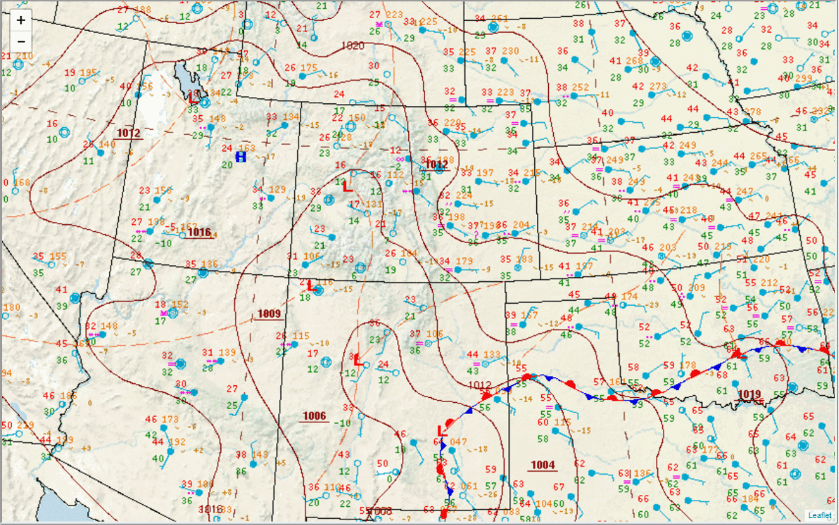 |
| Figure 1: 500 mb Loop (00Z 13 March - 12Z 15 March, 2021) showing storm track | Figure 2: 700 mb analysis at 12Z 14 March, 2021, just before peak of storm | Figure 3: Surface analysis from 12Z 13 March - 06Z 15 March, 2021 |
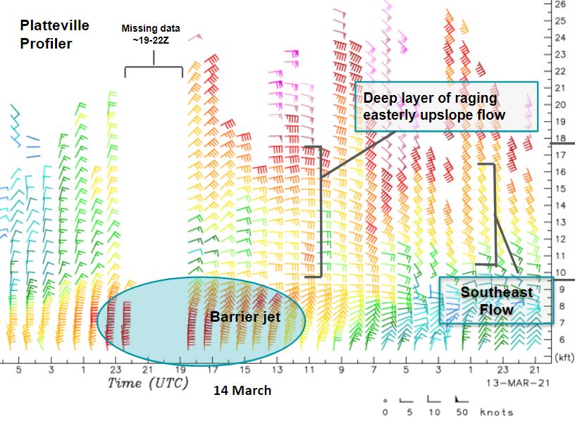
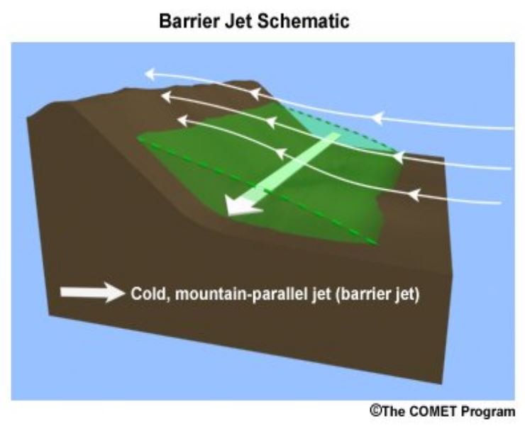
As mentioned above, this storm track is very favorable for heavy snow, resulting from the strong upslope flow into the Front Range. This flow regime can be seen in the Platteville Profiler (Figure 4), with the plot showing 25-35 knots of almost straight easterly winds developing in the 08Z-15Z (1 am - 8 am) time frame early on the 14th. Note the missing data after 19Z (noon) - that was unfortunately a result of the heavy snow and scattered power outages produced by this blizzard. That flow regime, combined with intense precipitation and melting effect on the plains and cold air knifing down the I-25 Corridor, created a barrier jet (Figure 5). This feature is known to intensify winds, and also aid precipitation production slightly farther east away from the terrain, as the feature is a cold dome and essentially acts like terrain itself, effectively displacing the best lift from upslope slightly to the east of the foothills, in this case, just east of I-25. We've also included the 12Z (5 am) 14 March Denver sounding, for additional data showing the intense upslope just off the deck, along with a fairly unstable profile between about 675 mb and 400 mb (~11,000 - 24,000 ft MSL). The combination of all these features led to widespread heavy snow and blizzard conditions along the Front Range, with snowfall rates peaking at 2-3" per hour and winds gusting to between 40 and 50 mph in many locations along the I-25 Corridor.
 |
 |
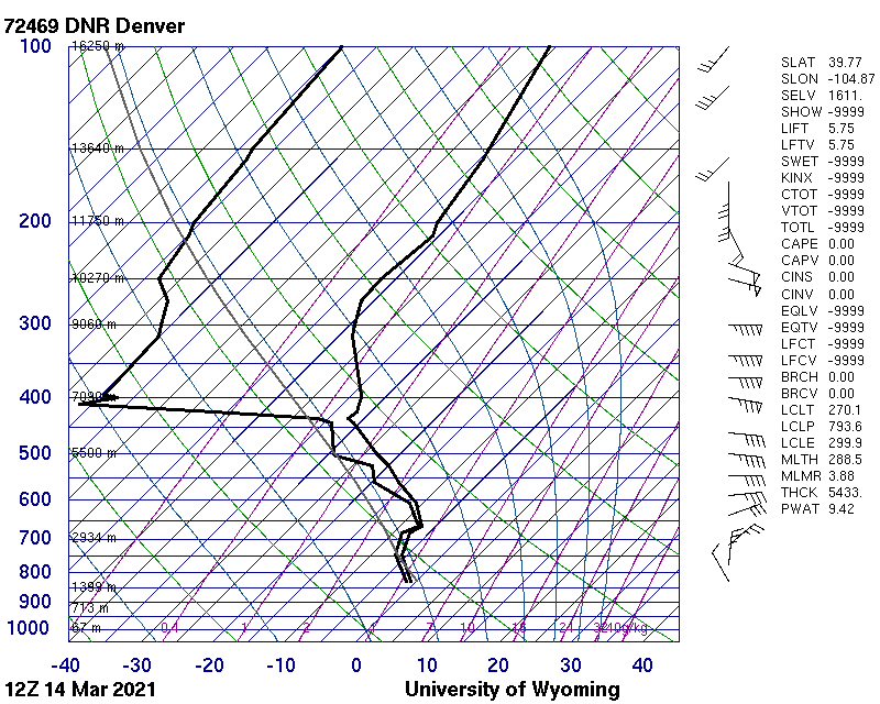 |
| Figure 4: Wind profiler from Platteville, CO (northeast of Denver)Note: Outage started early morning of March 14th | Figure 5: Schematic of a barrier jet, similar to what formed on March 14th | Figure 6: 12Z Denver Sounding |
 |
Media use of NWS Web News Stories is encouraged! Please acknowledge the NWS as the source of any news information accessed from this site. |
|