
Excessive rainfall may produce locally considerable flash flooding over parts of the northwestern Gulf Coast, lower Mississippi River Valley, and Deep South through Thursday. Potential Tropical Cyclone One is forecast to become a tropical storm (Arthur) as it moves along or just off the northwestern Gulf coast through Wednesday. An outbreak of severe weather is forecast in the Midwest Wednesday. Read More >
Overview: A powerful blizzard developed across the Front Range of Colorado late Tuesday, March 22, and continued through much of Wednesday, March 23, 2016. The storm tracked east/southeast across Utah Tuesday afternoon and evening, and then into Southeast Colorado by Wednesday morning. The storm rapidly intensified as the storm reached eastern Colorado, producing extremely heavy and intense snowfall with snowfall rates exceeding 3 inches per hour at times. In addition to heavy snow, strong winds gusting in excess of 50 mph east of Interstate 25 produced widespread blizzard conditions and zero visibilities. Further south across southern Colorado, peak wind gusts were between 70-80 mph.
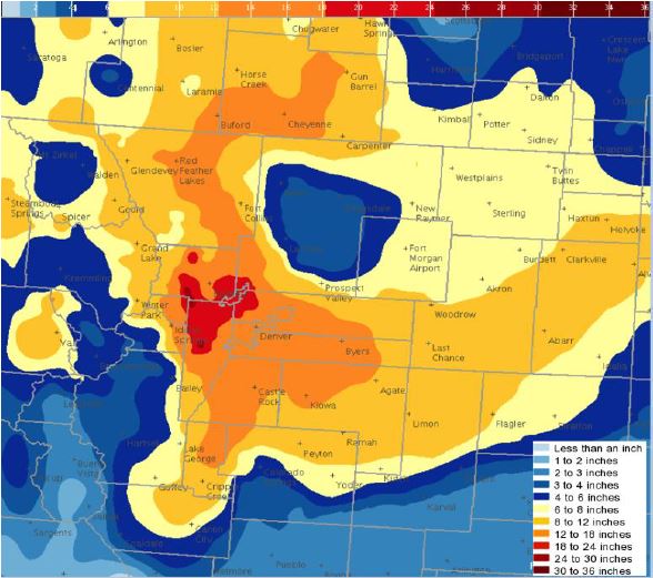
FIGURE 1: Storm total snow from the March 23, 2016 blizzard.
Impacts: The storm initially began with rain on the plains, but quickly changed over to snow during the early morning hours of Wednesday. Snowfall rates of 1 to 2 inches per hour were common, with several inches of snow already accumulating for the Wednesday morning commute. Many roads became impassable due to the depth of fallen snow, drifting snow, and near zero visibilities during the day Wednesday. During the peak of the storm, snowfall rates reached or exceeded 3 inches per hour. The high winds, heavy wet snowfall, extreme snowfall rates, and near zero visibilities combined to produce significant impacts for travelers by land and air, as well as causing numerous power outages for local residents. CDOT enacted its first ever traction law for the immediate Denver area shortly before 7 AM Wednesday morning, requiring all commercial motor vehicles to chain up and all passenger vehicles to have four wheel drive or adequate snow tires. Road closures including portions of Interstate 25 near the Wyoming border, Interstate 70 east of Airpark Road, and Highway 287 northwest of Fort Collins began early Wednesday morning. Conditions continued to deteriorate through the rest of the morning as both snow intensity and winds increased. Between 11 AM and 1245 PM, most roads were closed, including the majority of Interstate 25 outside of the immediate Denver Metro area, Interstate 70 east of Denver to the Kansas state line, and Interstate 76 northeast of Denver. Dozens of vehicles became stuck and a semi-truck jackknifed on I-25 near Monument Hill, shutting down I-25 and trapping an estimated 2,000 vehicles or more. Hundreds of vehicles were stuck or abandoned on other Colorado roads. Numerous rescues were conducted through local police departments as well as the National Guard. Meanwhile, air travel also shut down with near zero visibilities at Denver International Airport. Around 1,300 flights were cancelled. The airport was closed for approximately 7 hours. It was only the third closure in the airports history, and the first time since the December 20, 2006 blizzard. Numerous power outages occurred as heavy wet snow accumulated on trees, despite the strong winds. Xcel Energy stated 290,000 customers in the Denver area alone lost power, and more than 50,000 customers remained without power through Wednesday evening. Power failures at NWS Boulder led to required backup services provided by NWS Pueblo. Thankfully, there were no direct fatalities as a result of the blizzard.
Meteorological Evolution: A deep upper level trough moved into the Pacific Northwest during the morning hours of Tuesday, March 22nd, and then moved southeast into central Utah by Tuesday evening (Figure 2a). At the same time, surface low pressure deepened over eastern Colorado (Figure 2b).
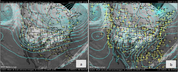
FIGURE 2. A. 500 mb heights, plot, and IR satellite. B. Surface MSLP countours, plot, and IR satellite. Valid at 0000 UTC 23 March, 2016 (6 PM MDT 22 March, 2016)
By early Wednesday morning, the upper low had cut off and was rapidly intensifying in Southeast Colorado as seen in Figure 3a. Meanwhile, the surface low pressure (Figure 3b) had begun to shift east into Kansas, but another piece of low pressure was holding back where strong surface pressure falls were occurring just ahead of the upper level low. This track was deeper, slower, and farther south and west than earlier model predictions had suggested, leading to much heavier snowfall than originally forecast for the Front Range Foothills and I-25 Urban Corridor from Fort Collins through Denver and the Palmer Divide.
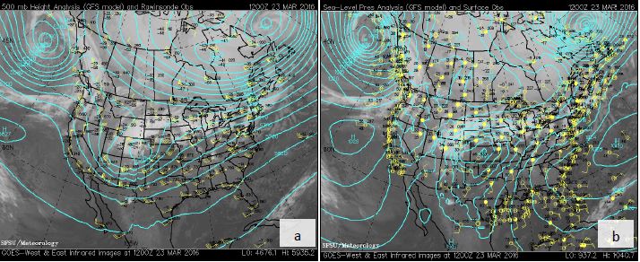
FIGURE 3. A. 500 mb heights, plot, and IR satellite. B. Surface MSLP countours, plot, and IR satellite. Valid at 1200 UTC 23 March, 2016 (6 AM MDT 23 March, 2016)
With regard to progression of precipitation and the blizzard, heavy snow spread across the Front Range foothills by the midnight hour Tuesday night (March 23, 2016), while on the I-25 Urban Corridor the precipitation initially fell as rain. However, that rain quickly changed to a heavy and very wet snowfall (Radar Loop in Figure 4) with snow to liquid ratios close to 7:1. As a result, roads quickly became snow and slush covered making for difficult and hazardous travel in the early morning hours Wednesday.
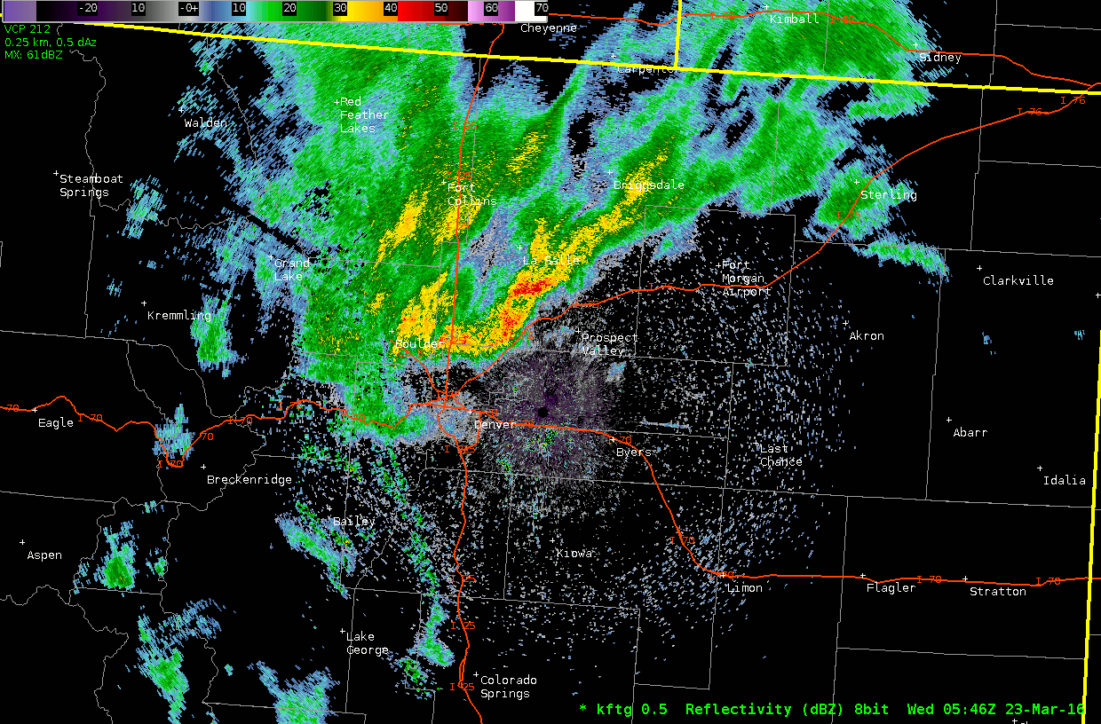
FIGURE 4: KFTG radar reflectivity data from midnight through 5 PM. You'll notice a few jumps in the data, which are the result of communication issues during of the blizzard when radar data became temporarily unavailable. The 30-40 dBZ snow (yellow) part way through the loop, lasting until the end, indicates the heavy snow.
The area of heaviest snow with snowfall rates near 2 inches per hour shifted slightly eastward to just east of Interstate 25 between 6 and 7 AM, but then stalled and retrograded toward the Front Range Foothills again between 830 AM and 11 AM. In most storms, once the heavier snow band moves off the foothills it is very difficult to shift back westward again to the Front Range. This was not the case in this event and further research will be needed to diagnose the interaction between convection and the deformation zone in this storm. Snowfall rates in this extremely heavy band of snow were near a whopping 3 inches per hour, with a few observations suggesting close to 4 inch per hour rates as 0.5 degree KFTG radar reflectivity topped 40 dBZ (Figure 4). Winds had also increased across the plains, as 40 to 55 mph wind gusts (Figure 5) produced widespread blizzard conditions.
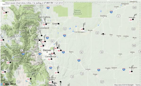
FIGURE 5: Sustained wind speeds (10 kts every long barb, 5 kts for a short barb), and peak wind gusts (in red) from the time period of 10 AM - 11 AM on March 23, 2016.
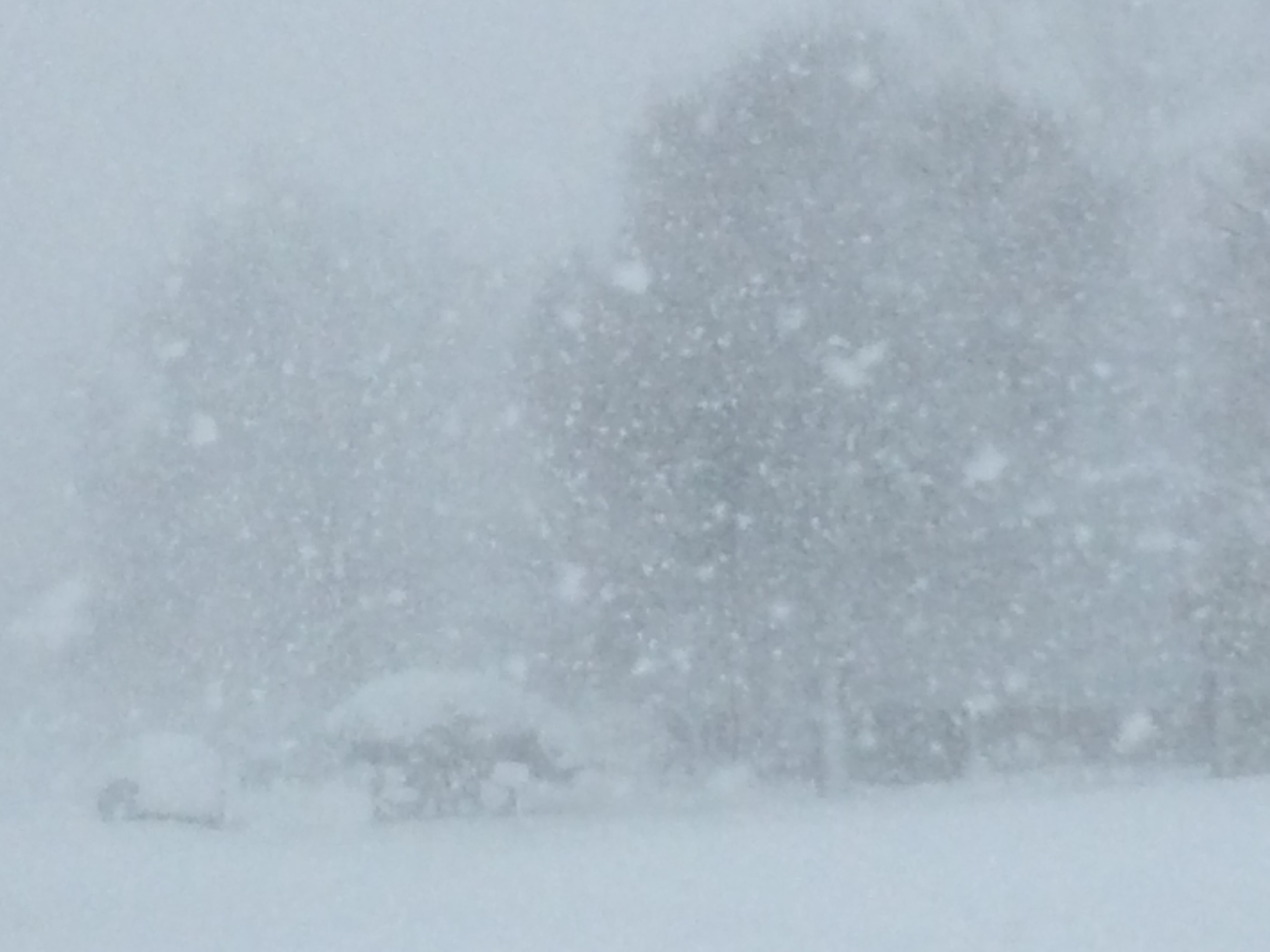
FIGURE 6: The view in Broomfield at 10:18 am Wednesday morning when snowfall rates neared 3-4 inches/hour.
The radar doppler velocity values indicated the intensity of the winds the morning of March 23 (Figure 7)The peak intensity of this storm continued through mid-afternoon with widespread high impacts to travel by land and air. The snow intensity gradually decreased by late afternoon and ended in the evening as the storm pushed quickly east into the Central Plains. Storm totals (Figure 1 at the top) ranged from just a few inches over portions of the northeast Colorado Plains, to near 2 feet and considerably higher than originally forecast in the northwest sections of Denver and portions of the Front Range Foothills.
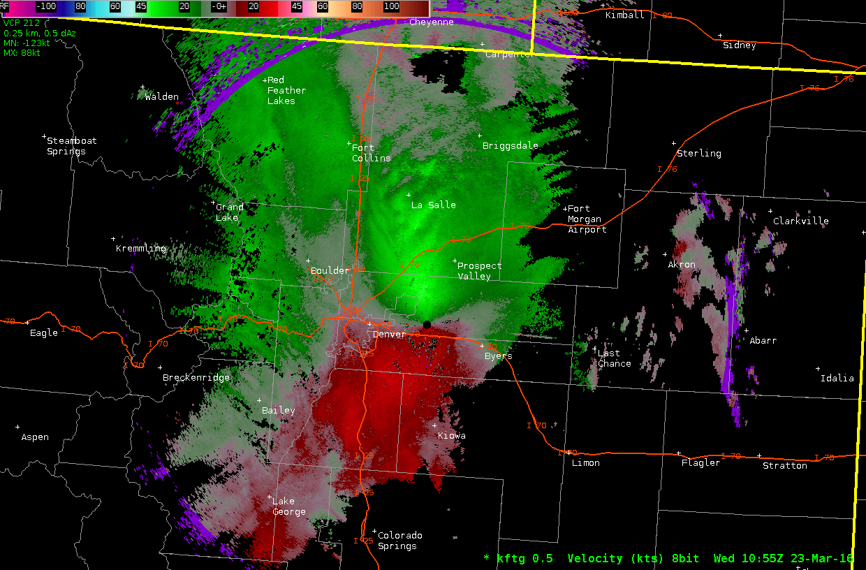
FIGURE 7: KFTG Doppler velocity for March 23, 2016 from roughly 5 AM through 6 PM. Doppler velocity is in kts. Keep in mind the further away from the radar (black circle right of center), the higher above the surface the winds are being measured. Within a 5 mile radius of the radar, the Doppler velocity winds will mirror winds near the surface. Also, because the radar can only measure the speed of the wind towards or away from the radar, you only see the strongest winds from north (toward the radar) to south (away from the radar). Those intense winds were nevertheless impacting just about the entire region along and east of I-25.

