|
|
| 7 Day Liquid Precipitation Totals: NOTE: Marker locations are approximate and are not accurate to street level. Precipitation reports are estimates from the following sources - NWS Spotters, NWS Doppler Radar, COCORAHS, NWS COOP and USDA/NRCS SNOTEL Data |
|
|
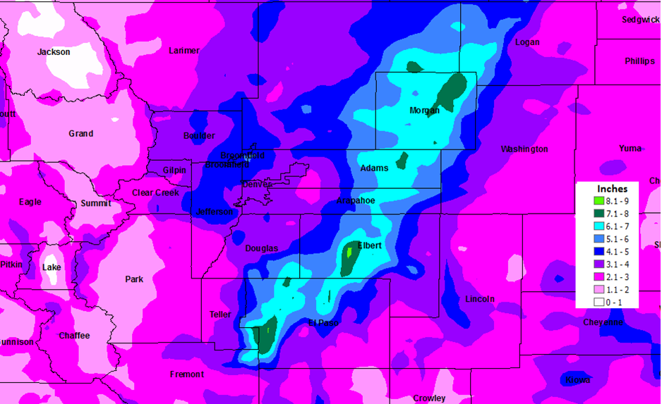
| Zoomed in 10 Day Liquid Precipitation Totals: NOTE: Marker locations are approximate and are not accurate to street level. Precipitation reports are estimates from the following sources - NWS Spotters, COCORAHS, NWS COOP and USDA/NRCS SNOTEL Data |
|
> |
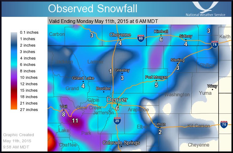
| 7 Day Snowfall Totals: NOTE: Marker locations are approximate and are not accurate to street level. Snowfall reports are estimates from the following sources - NWS Spotters, COCORAHS, NWS COOP and USDA/NRCS SNOTEL Data. |
| Click Here for the latest Storm Reports |
|
7 Day Snowfall and 10 Day Liquid Precipitation Totals across NE Colorado
|
|
7 Day Snowfall Totals (Inches) (SNOTEL, Spotters)
|
|
10 Day Precip Totals (Inches) (CoCoRahs)
|
| Location |
Snowfall |
County/Elevation |
| Wolf Creek Summit |
26 |
11000 |
| Sharkstooth |
23 |
10720 |
| Echo Lake |
23 |
10600 |
| Berthoud Summit |
23 |
11300 |
| Columbus Basin |
22 |
10785 |
| Red Mountain Pass |
22 |
11150 |
| Buckskin Joe |
22 |
11150 |
| Hayden Pass |
21 |
10720 |
| University Camp |
20 |
10300 |
| Fool Creek |
20 |
11150 |
| Loveland Basin |
20 |
11400 |
| Schofield Pass |
19 |
10700 |
| Beartown |
19 |
11600 |
| Arapaho Ridge |
19 |
10960 |
| Glen Cove |
19 |
11460 |
| Park Reservoir |
18 |
9960 |
| Porphyry Creek |
17 |
10760 |
| Spud Mountain |
17 |
10660 |
| Fremont Pass |
17 |
11400 |
| Niwot |
17 |
9910 |
| Ivanhoe |
16 |
10400 |
| Jones Pass |
16 |
10400 |
| South Colony |
16 |
10800 |
| Jackwhacker Gulch |
15 |
10960 |
| Elliot Ridge |
12 |
10520 |
| Grizzly Peak |
11 |
11100 |
| Never Summer |
10 |
10280 |
| Sawtooth |
10 |
9620 |
| 2 N CENTENNIAL |
9.5 |
ARAPAHOE |
| 3 ESE PERRY PARK |
9 |
DOUGLAS |
| 3 SSE AURORA |
9 |
ARAPAHOE |
| Joe Wright |
9 |
10120 |
| Willow Park |
9 |
10700 |
| Rough and Tumble |
9 |
10360 |
| Michigan Creek |
9 |
10600 |
| High Lonesome |
9 |
10620 |
| Sargents Mesa |
9 |
11530 |
| 2 SSE BRECKENRIDGE |
8.5 |
SUMMIT |
| SE AURORA |
8.5 |
ARAPAHOE |
| 5 SSE AURORA |
8.3 |
ARAPAHOE |
| 1 WNW AURORA |
8 |
ARAPAHOE |
| 10 N ELIZABETH |
8 |
ELBERT |
| 2 NW AURORA |
8 |
ARAPAHOE |
| 2 WNW AURORA |
8 |
ARAPAHOE |
| 3 W CONIFER |
8 |
JEFFERSON |
| Ripple Creek |
8 |
10340 |
| Lone Cone |
8 |
9600 |
| Lake Irene |
8 |
10700 |
| Upper San Juan |
8 |
10130 |
| Trinchera |
8 |
10900 |
| 1 W NORTHGLENN |
7.2 |
ADAMS |
| 1 WNW PONDEROSA PARK |
7 |
ELBERT |
| 4 SW ELIZABETH |
7 |
ELBERT |
| 1 S CASTLE PINES |
6.7 |
DOUGLAS |
| 3 NW IDLEDALE |
6.3 |
JEFFERSON |
| 1 NNW LOUISVILLE |
6.1 |
BOULDER |
| 1 NNW FEDERAL HEIGHTS |
6 |
ADAMS |
| 1 SE EVERGREEN |
6 |
JEFFERSON |
| 1 WSW BROOMFIELD |
5.1 |
BROOMFIELD |
| 2 NE THORNTON |
5.1 |
ADAMS |
| 1 N HIGHLANDS RANCH |
5 |
ARAPAHOE |
| 1 SW WESTMINSTER |
5 |
JEFFERSON |
| 5 ENE CENTENNIAL |
5 |
ARAPAHOE |
| ANTERO JUNCTION |
5 |
PARK |
| 1 SW EVERGREEN |
4.5 |
JEFFERSON |
| 2 N FORT MORGAN |
4.5 |
MORGAN |
| WESTMINSTER |
4.5 |
ADAMS |
| 3 N BLACK HAWK |
4.4 |
GILPIN |
| 3 ESE TINY TOWN |
4.1 |
JEFFERSON |
| 4 E GREELEY |
4 |
WELD |
| DENVER INTL AIRPORT |
4 |
DENVER |
| GENESEE |
4 |
JEFFERSON |
|
|
| Station Name |
Total Precip |
| Ivywild 0.6 E |
8.21 |
| Colorado Springs 18.7 N |
8.15 |
| Colorado Springs 7.0 NNE |
7.92 |
| Colorado Springs 2.0 N |
7.46 |
| Brush 0.3 E |
7.3 |
| Willard 0.4 NW |
7.13 |
| Falcon Estates 2.4 WNW |
7.12 |
| Fort Morgan 6.2 NE |
7.09 |
| New Raymer 3.4 WSW |
7.05 |
| Colorado Springs 2.1 NW |
6.69 |
| Colorado Springs 7.1 NNW |
6.6 |
| Fort Morgan 5.1 WNW |
6.6 |
| Byers 8.1 SSE |
6.17 |
| Gleneagle 0.4 WNW |
6.17 |
| Black Forest 3.4 NNE |
6.02 |
| Brush 7.3 SSE |
6.02 |
| Colorado Springs 9.5 NNE |
5.94 |
| Elbert 4.6 SSE |
5.79 |
| Monument 3.8 NE |
5.76 |
| Greeley 10.5 SSE |
5.68 |
| Calhan 3.1 N |
5.55 |
| Colorado Springs 6.4 NE |
5.55 |
| Peyton 8.3 SW |
5.48 |
| Northglenn 0.4 WSW |
5.4 |
| Colorado Springs 3.7 ENE |
5.37 |
| Broomfield 1.3 SSW |
5.23 |
| Broomfield 1.2 NE |
5.17 |
| Franktown 5.4 SE |
5.16 |
| Hillrose 2.5 SSW |
5.1 |
| Elizabeth 2.0 NNE |
5.09 |
| Dacono 0.4 NNW |
5.08 |
| Westminster 1.6 NE |
4.99 |
| Erie 1.7 WNW |
4.83 |
| Larkspur 2.2 WNW |
4.82 |
| Evergreen 3.2 ESE |
4.73 |
| Broomfield 2.3 SSW |
4.72 |
| Ken Caryl 0.6 WSW |
4.68 |
| Littleton 7.7 ESE |
4.67 |
| Conifer 4.2 ENE |
4.65 |
| Jamestown 2.5 SSE |
4.64 |
| Bennett 11.3 SSW |
4.63 |
| Lakewood 0.9 SSW |
4.63 |
| Evergreen 3.6 SSW |
4.61 |
| Evergreen 2.0 ESE |
4.61 |
| Westminster 1.6 ESE |
4.59 |
| Lafayette 2.5 NW |
4.56 |
| Kiowa 2.2 WNW |
4.55 |
| Thornton 2.1 N |
4.47 |
| Brighton 4.0 WNW |
4.43 |
| Longmont 1.8 E |
4.39 |
| Kittredge 2.5 SSE |
4.39 |
| Littleton 6.0 W |
4.39 |
| Colorado Springs 6.6 SE |
4.38 |
| Evergreen 5.3 S |
4.37 |
| Longmont 1.8 ENE |
4.35 |
| Lovelandeland 2.4 SSE |
4.35 |
| Golden 4.8 NW |
4.29 |
| Littleton 6.4 W |
4.29 |
| Evergreen 3.5 W |
4.27 |
| Berthoud 5.0 WSW |
4.23 |
| Kersey 6.9 ESE |
4.23 |
| Elizabeth 1.7 WSW |
4.22 |
| Kersey 4.5 E |
4.19 |
| Ken Caryl 2.9 NNW |
4.17 |
| Boulder 1.6 S |
4.16 |
| Evergreen 5 W |
4.16 |
| Colorado Springs 8.2 SE |
4.16 |
| Boulder 3.5 S |
4.15 |
| Black Hollow Reservoir 3.0 WSW |
4.13 |
| Castle Pines 2.2 N |
4.12 |
| Denver 11.0 SSW |
4.11 |
| Louisville 0.7 NW |
4.09 |
| Chatfield Dam 2 NW |
4.09 |
| Loveland 3.8 S |
4.09 |
| Boulder 2.9 S |
4.07 |
| Wellington 1.8 NE |
4.06 |
| Denver 4.7 SW |
4.04 |
| Fort Collins 8.2 E |
4.04 |
| Eads 6.1 ESE |
4.03 |
| Fort Collins 3.7 S |
4.01 |
| Arvada 3.3 NNW |
4 |
| Evergreen 1.1 S |
3.99 |
| Greeley 3.9 ENE |
3.98 |
| Brighton 1.9 NNW |
3.97 |
| Boulder 4.7 ENE |
3.97 |
| Greeley 1.8 N |
3.96 |
| Lafayette 0.8 WSW |
3.94 |
| Superior 0.4 WNW |
3.92 |
| Wheat Ridge 0.6 S |
3.92 |
| La Junta 1.0 S |
3.92 |
| Lakewood 1.7 SW |
3.91 |
| Kersey 1.3 WSW |
3.91 |
| Lovelandeland 3.1 SW |
3.89 |
| Lakewood 1.2 E |
3.88 |
| Longmont 2.1 N |
3.87 |
| Denver 6.6 W |
3.87 |
| Lakewood 2.2 ESE |
3.86 |
| Lovelandeland 2.7 E |
3.86 |
| Boulder 1.3 NW |
3.85 |
| Denver 6.3 SSE |
3.84 |
| Lyons 0.3 NNE |
3.84 |
| Sterling 1.5 S |
3.84 |
| Greeley 6.6 E |
3.84 |
| Greeley 1.7 ESE |
3.83 |
| Fort Collins 3.7 SW |
3.82 |
| Fort Collins 2.8 W |
3.82 |
| Denver 6.2 SSE |
3.81 |
| Sterling 1.5 SSE |
3.79 |
| Denver 13.4 ENE |
3.78 |
| Boulder 2.0 W |
3.76 |
| Lovelandeland 3.8 SW |
3.76 |
| Lyons 4.8 N |
3.75 |
| Rocky Ford 2.9 ESE |
3.75 |
| Longmont 2.6 NW |
3.72 |
| Wheat Ridge 0.9 WSW |
3.72 |
| Hygiene .79 N |
3.69 |
| Castle Rock 4.6 NNW |
3.68 |
| Aurora 3.3 S |
3.67 |
| Niwot 0.7 NNW |
3.67 |
| Fort Collins 2.8 WSW |
3.67 |
| Lovelandeland 4.7 SW |
3.64 |
| Evergreen 4.6 S |
3.63 |
| Timnath 4.1 NNE |
3.63 |
| Lovelandeland 3.0 NNE |
3.63 |
| Thornton 2.3 SSE |
3.62 |
| Littleton 1.5 NE |
3.61 |
| Aurora 2.8 WSW |
3.59 |
| Wheat Ridge 2.8 WSW |
3.58 |
| Greeley 1.1 ENE |
3.58 |
| Fort Collins 5.6 E |
3.57 |
| Boulder 7.4 NNW |
3.56 |
| Bellvue 1 NW |
3.55 |
| Briggsdale 0.5 WNW |
3.55 |
| Fort Collins 1.7 SE |
3.53 |
| Wellingtonlington 0.4 NW |
3.53 |
| Wellingtonlington 0.8 SW |
3.53 |
| Bellvue 1.0 S |
3.52 |
| Fort Collins 0.7 SSW |
3.51 |
| Lovelandeland 7 SE |
3.49 |
| Niwot 2.3 W |
3.48 |
| Fort Collins 4.6 N |
3.48 |
| Fort Collins 0.3 SSE |
3.48 |
| Rollinsville 0.1 N |
3.47 |
| Lovelandeland 3.4 NNE |
3.47 |
| Nunn 1.2 ENE |
3.47 |
| Fort Collins 2.2 NW |
3.45 |
| Castle Pines 2.2 NNE |
3.44 |
| Fort Collins 0.7 SSW |
3.44 |
| Fort Collins 3.0 NW |
3.43 |
| Fort Collins 3.5 N |
3.42 |
| Fort Collins 1.3 ENE |
3.42 |
| The Pinery 1.2 ESE |
3.41 |
| Fort Collins 2.55 NE |
3.41 |
| Wellingtonlington 3.7 WNW |
3.41 |
| Lyons 6.2 NW |
3.41 |
| Sterling 3.7 NNE |
3.41 |
| Greeley 2.4 E |
3.41 |
| Punkin Center 7.2 NNW |
3.4 |
| Littleton 0.3 NNE |
3.39 |
| Lovelandeland 2.4 NW |
3.39 |
| Fort Collins 1.6 SSW |
3.39 |
| Fort Lupton 7.4 NW |
3.39 |
| Woodland Park 1.6 N |
3.38 |
| Littleton 2.0 ENE |
3.36 |
| Englewood 1.4 N |
3.36 |
| Pueblo West 3.4 SSW |
3.36 |
| Aurora 5.2 SSE |
3.35 |
| Aurora 10.0 SSE |
3.34 |
| Boulder 3.0 NNW |
3.34 |
| Bellvue 5.9 W |
3.34 |
| Greeley 2.6 W |
3.34 |
| Fort Collins 5.4 N |
3.32 |
| Nederland 0.4 WNW |
3.31 |
| Sterling 15 SE |
3.31 |
| Woodrow 4.6 SE |
3.31 |
| Eaton 3.4 SE |
3.29 |
| Fort Collins 2.8 NE |
3.28 |
| Aurora 2.4 SW |
3.27 |
| Franktown 3.5 NE |
3.27 |
| Rollinsville 1.1 SSW |
3.27 |
| Denver 5.3 SW |
3.24 |
| Bellvue 4.0 NW |
3.22 |
| Nunn 6.5 NE |
3.22 |
| Castle Rock 3.9 NW |
3.2 |
| Fort Collins 3.2 NE |
3.17 |
| Greeley 5.2 SW |
3.15 |
| Nederland 2.8 NE |
3.14 |
| Fort Collins 5.3 N |
3.12 |
| Wellingtonlington 3.9 SW |
3.1 |
| Wray 4.2 NNE |
3.1 |
| Greeley 3.8 W |
3.08 |
| Castle Rock 2.9 WNW |
3.07 |
| Fort Collins 4.9 N |
3.07 |
| Florissant 4.8 NNE |
3.05 |
| Wray 1.2 WSW |
3.03 |
| Aurora 3.0 N |
3.02 |
| Cheyenne Wellingtonls 1.6 N |
3.02 |
| Foxfield 3.7 ESE |
2.99 |
| Vona 6.5 SSW |
2.99 |
| Eaton 3.6 WSW |
2.94 |
| Centennial 2.0 SW |
2.91 |
| The Pinery 0.5 WNW |
2.9 |
| Sedalia 6.8 S |
2.86 |
| Greeley 4.6 WNW |
2.85 |
| Bellvue 5.0 W |
2.83 |
| Pueblo West 6.0 W |
2.77 |
| Pueblo West 6.2 WSW |
2.76 |
| Wray 1.9 SE |
2.75 |
| Wray 20.4 NNE |
2.73 |
| Littleton 1.6 NW |
2.7 |
| Fort Collins 4.8 SE |
2.7 |
| Carbondale 5.7 E |
2.69 |
| Rye 11.2 E |
2.67 |
| Vernon 6.4 WSW |
2.67 |
| Pine 3.4 NNW |
2.63 |
| Pueblo West 3.8 WSW |
2.62 |
| Bailey 4.5 NE |
2.61 |
| Vail 0.9 WNW |
2.58 |
| Florence 0.9 W |
2.58 |
| Eads 16.6 SW |
2.58 |
| Steamboat Springs 1 SE |
2.58 |
| Wray 2.4 ENE |
2.55 |
| Crested Butte 6.2 N |
2.52 |
| Pine 1.3 ENE |
2.52 |
| Holyoke 13 SE |
2.52 |
| Aurora 0.7 WSW |
2.5 |
| Empire .2 E |
2.5 |
| Wray 0.6 SSW |
2.48 |
| Lake George 7.2 WNW |
2.44 |
| Crestone 1.2 SSE |
2.43 |
| Holyoke 0.3 WSW |
2.42 |
| Estes Park 2.2 NE |
2.41 |
| Pueblo 4.3 N |
2.41 |
| Rye 1.0 SSE |
2.39 |
| Estes Park 1.8 SSE |
2.38 |
| Pueblo West 1.9 SW |
2.38 |
| Livermore 10.5 WSW |
2.37 |
| Milliken 2.7 NNW |
2.35 |
| Penrose 1.7 WNW |
2.33 |
| Walsenburg 1.0 WNW |
2.31 |
| Cotopaxi 4.9 SE |
2.3 |
| Parker 2.4 NW |
2.29 |
| Estes Park 1.8 S |
2.29 |
| Glenwood Springs 1.7 NW |
2.28 |
| Pueblo 2.5 SSW |
2.25 |
| Glenwood Springs 5.3 SSE |
2.21 |
| Basalt 5.8 E |
2.16 |
| Bailey 6.4 NNW |
2.16 |
| Rifle 0.9 NE |
2.12 |
| Anton 5.8 SE |
2.1 |
| Flagler 0.25 SE |
2.07 |
| Glenwood Springs 1.4 S |
2.06 |
| Liberty 15 SW |
2.04 |
| Rye 5.9 ESE |
2.04 |
| Glenwood Springs .64 S |
2.02 |
| Pueblo 17 W |
2.02 |
| Carbondale 0.5 W |
1.99 |
| Yoder 4.2 SE |
1.97 |
| Paonia 2.1 SSE |
1.9 |
| Canon City 0.7 NNW |
1.88 |
| Penrose 2.3 NNW |
1.87 |
| Wray 23.2 S |
1.81 |
| Gypsum 1.9 SSW |
1.79 |
| Glenwood Springs 2.7 SSE |
1.76 |
| Westcliffe 6.2 W |
1.75 |
| Canon City .84 SE |
1.75 |
| Salida 9.2 NW |
1.73 |
| Montrose 7.3 ENE |
1.72 |
| Pueblo 0.1 NW |
1.7 |
| Fruita 4.5 NNE |
1.66 |
| Ouray .23 NNW |
1.65 |
| Collbran 0.2 ESE |
1.61 |
| Palisade 3.3 ENE |
1.58 |
| Grand Lake 1.5 WNW |
1.57 |
| Dolores 4.8 ENE |
1.56 |
| Stonington 8.6 SE |
1.55 |
| Pagosa Springs 1.6 SSW |
1.49 |
| Aguilar 7.2 WSW |
1.45 |
| Keystone 0.7 SW |
1.43 |
| Hotchkiss 5.1 WNW |
1.36 |
| Parlin 2.7 ESE |
1.32 |
| Twin Lakes 3.1 WSW |
1.3 |
| Westcliffe 8.4 WNW |
1.29 |
| Powderhorn 4.4 NNE |
1.29 |
| Trinidad 11.9 ENE |
1.24 |
| Hotchkiss 7.1 WNW |
1.22 |
| Hesperus 6.9 S |
1.2 |
| Paonia 1.3 NNW |
1.18 |
| Montrose 2.0 E |
1.18 |
| Dinosaur 0.3 SW |
1.17 |
| Grand Junction 1.0 E |
1.08 |
| Leadville 6.3 S |
1.07 |
| Montrose 2.3 ENE |
1.05 |
| Eckert 1.1 SW |
1.04 |
|
|