The winter of 1999-2000 was a La Nina winter. Like most La Nina winters in northeast Ohio and northwest PA, there was some concentrated cold and snow. The first half of the season was mild. There was one notable lake effect snow on December 23rd when a west wind deposited two feet of snow on the Lake Erie lake shore from Mentor and Painesville to Erie, PA. The remainder of the winter was concentrated from mid January to the third week of February with persistent cold and frequent snow. There were no particularly heavy snows during this time but a relatively deep snow cover developed, especially in the snowbelt of extreme northeast Ohio and northwest Pennsylvania. The weather warmed dramatically by the end of February and the mercury reached 70F!. March was mild and April stubbornly spit out a few more snows.
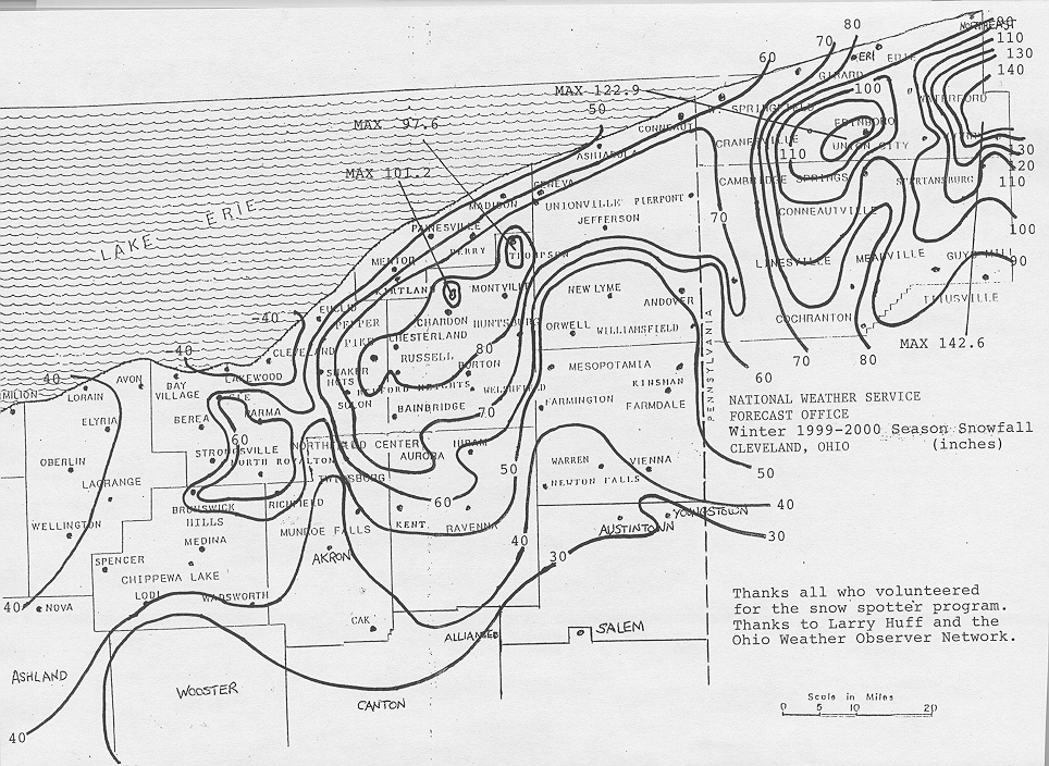
Seasonal snow was generally below normal except near normal in the snowbelt. Snow totals in northern Ohio ranged from around 25 inches across northwest Ohio to around 40 inches in northeast Ohio to about 100 inches in northern Geauga County in the northeast Ohio snowbelt. Totals in northwest Pennsylvania ranged from about 80 inches near Lake Erie to 150 inches plus in the heart of the Pennsylvania snowbelt south of interstate 90.
Temperatures were above normal each month of the winter season except January 2000 which was near normal at most sites.
| 1999-'2000 | Oct 99 | Nov 99 | Dec 99 | Jan 00 | Feb 00 | Mar 00 | Apr 00 | May 00 | Total 99-2000 |
| Toledo | 0.0 | T | 3.1 | 12.2 | 4.7 | 2.5 | 0.2 | 0.0 | 22.7 |
| Mansfield | T | 2.3 | 4.7 | 16.9 | 7.7 | 2.7 | 0.7 | 0.0 | 35.0 |
| Cleveland | T | 1.6 | 10.3 | 24.7 | 13.9 | 8.0 | 1.0 | 0.0 | 59.5 |
| Akron-Canton | 0.0 | 3.9 | 5.7 | 14.1 | 10.3 | 1.9 | 1.4 | T | 37.3 |
| Youngstown | 0.0 | 7.2 | 8.3 | 15.0 | 7.7 | 3.0 | 1.7 | 0.0 | 42.9 |
| Erie PA | T | 0.6 | 29.7 | 24.3 | 10.7 | 6.5 | 0.7 | 0.0 | 72.5 |

