Overview
|
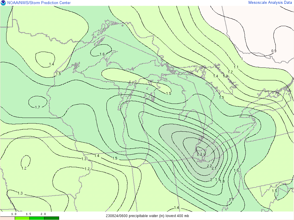
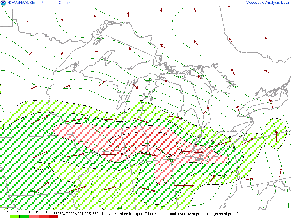
An anomalously-warm and moist air mass was in place across much of the Central Plains and Midwest, resulting in strong to perhaps extreme instability in addition to tropical-like precipitable water values exceeding 2.0 inches. The Lower Great Lakes region, specifically northern Ohio and Northwest Pennsylvania found itself on the eastern edge of this “heat dome”. Strong northwest flow aloft persisted along the periphery of the anomalously-warm and moist air mass, allowing for organized storms to develop across northern Ohio and Northwest Pennsylvania. A constant feed of moisture allowed these storms to maintain their intensity throughout the evening and overnight hours of Aug 23, 2023 and into the early morning hours of Aug 24, 2023 as they slowly pivoted southwest. Numerous flash flood warnings were issued with 3 “considerable” tags utilized throughout the course of the event. The hardest-hit areas were along the lakeshore between Toledo and Cleveland where there were several reports of 5 to 7 inches of rainfall. Elsewhere, generally 2 to 4 inches of rainfall was common, most of which fell in only a few hours. |
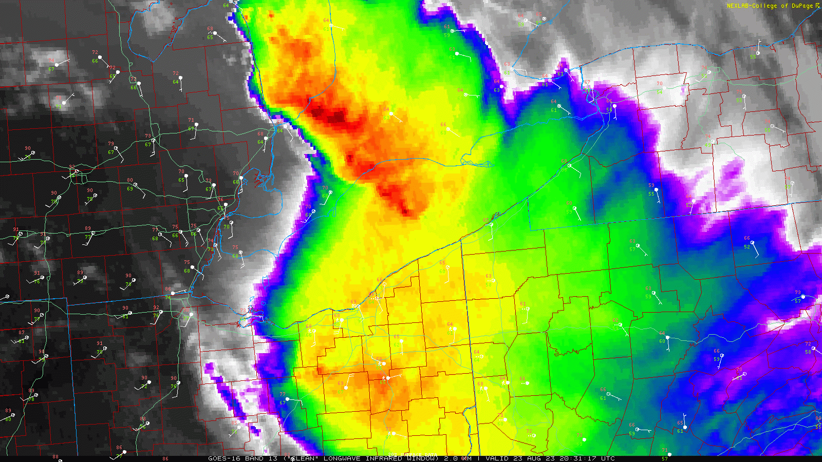 Satellite infrared loop from August 23, 2023 4:30 PM EDT through August 24, 2023 6:30 AM EDT. |
Photos & Video
 |
 |
 |
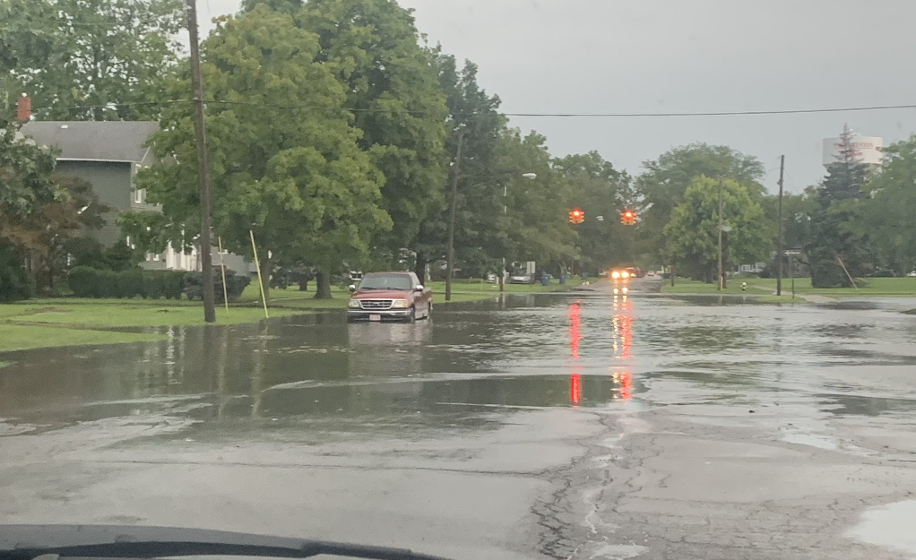
| Flooding off of route 303 in Grafton, OH. Credit: Jess Jacobs | Flooding in Port Clinton, OH. Credit: Emerson Young | Additional flooding off of route 303 in Grafton, OH. Credit: Jess Jacobs |
 |
 |
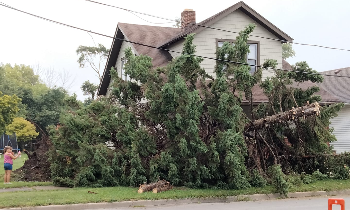
| Tree downed in Sandusky, OH. Credit: Kaylah Gonzalez | Flooding with water rescues on I-90 just west of Cleveland, OH. |
Radar
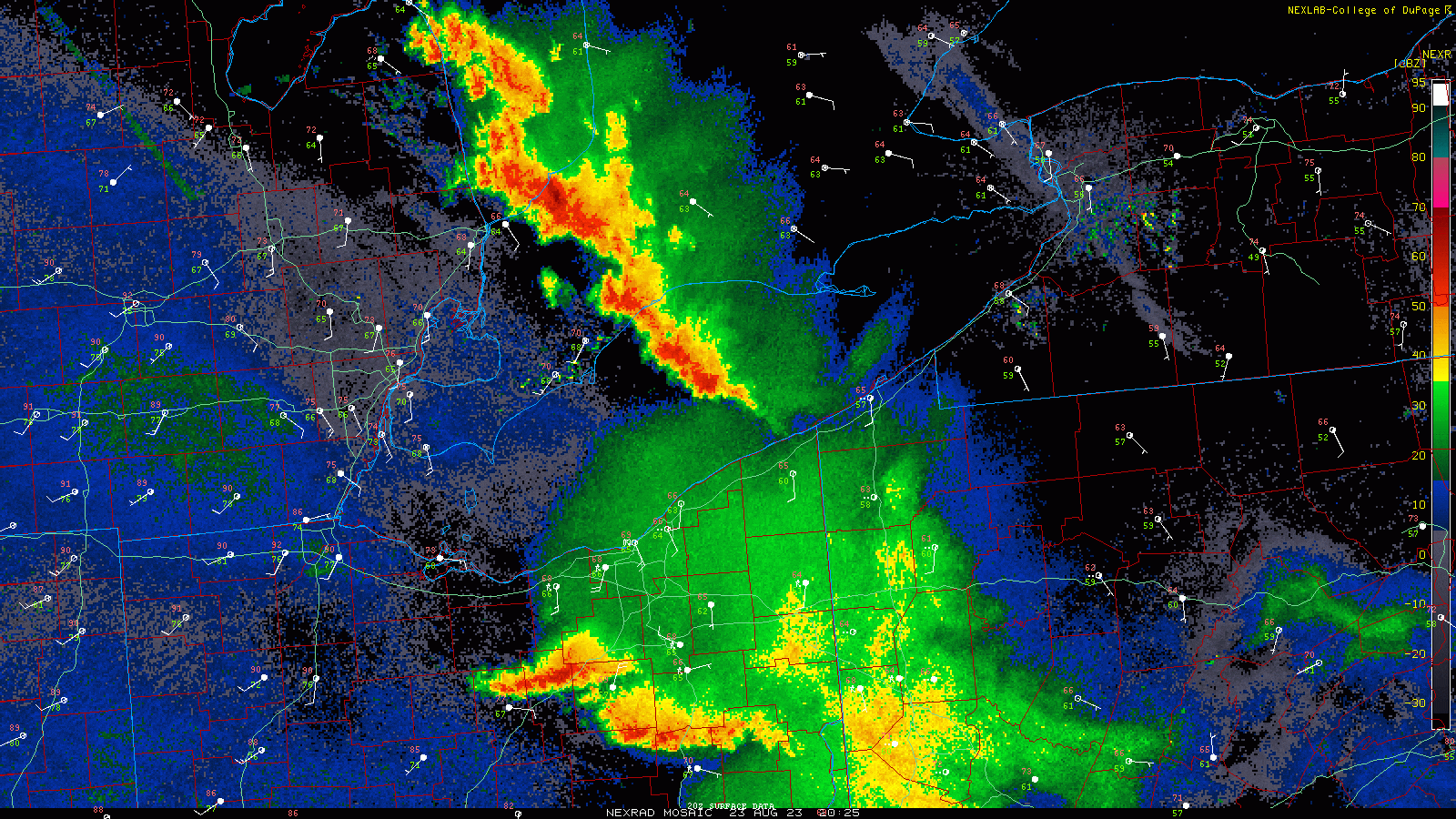 |
| Radar loop from August 23, 2023 4:30 PM EDT through August 24, 2023 6:30 AM EDT. |
 |
 |
 |
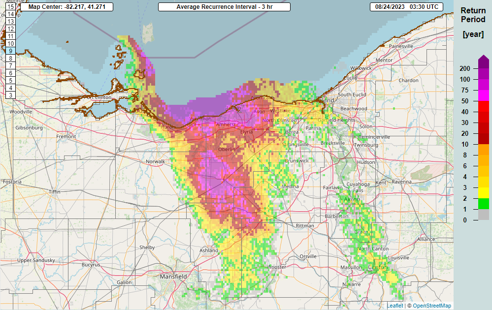 |
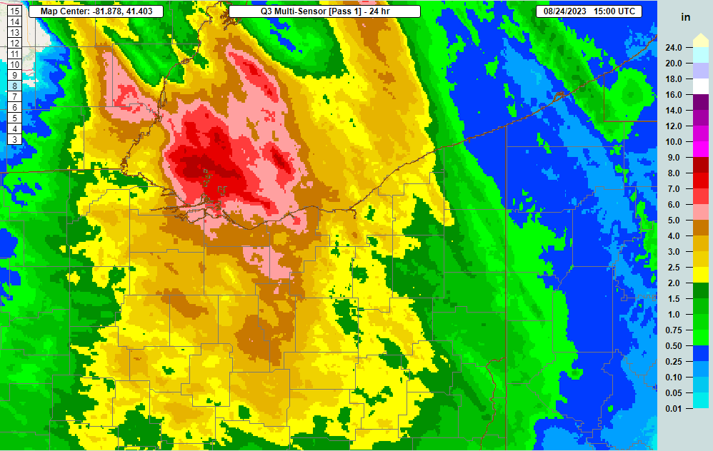
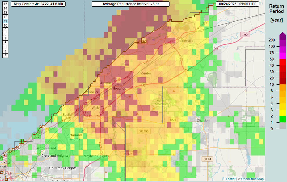
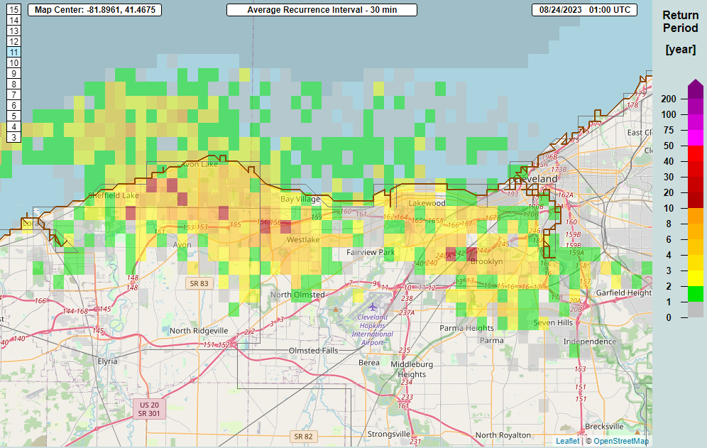
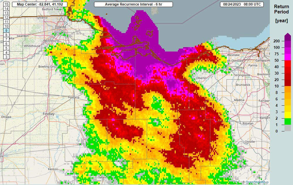
| MRMS multi-sensor rainfall estimate from 11 AM August 23 through 11 AM August 24. Yellows indicate values over 2" with reds indicating 5"+. | MRMS estimated 3-hour rainfall average return interval from 6-9 PM August 23. The reds indicate a rainfall amount that typically falls every 10-20 years in western Lake, northeastern Cuyahoga and northwestern Geauga County where flash flooding occurred. | MRMS estimated 30 minute rainfall average return interval from 8:30-9:00 PM August 23. The yellows and reds indicate an amount of rain that typically occurs every 5-10 years from northern Lorain County into western Cuyahoga County and Cleveland where flash flooding occurred. | MRMS estimated 3-hour rainfall average return interval from 8:30-11:30 PM August 23. The reds indicate an average 10-50 year return interval, with purples indicating 50-200 years. Widespread flash flooding occurred in parts of Lorain and northern Ashland Counties. |
 |
 |
 |
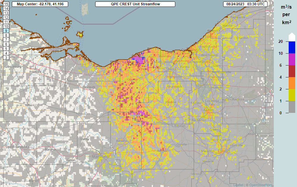 |
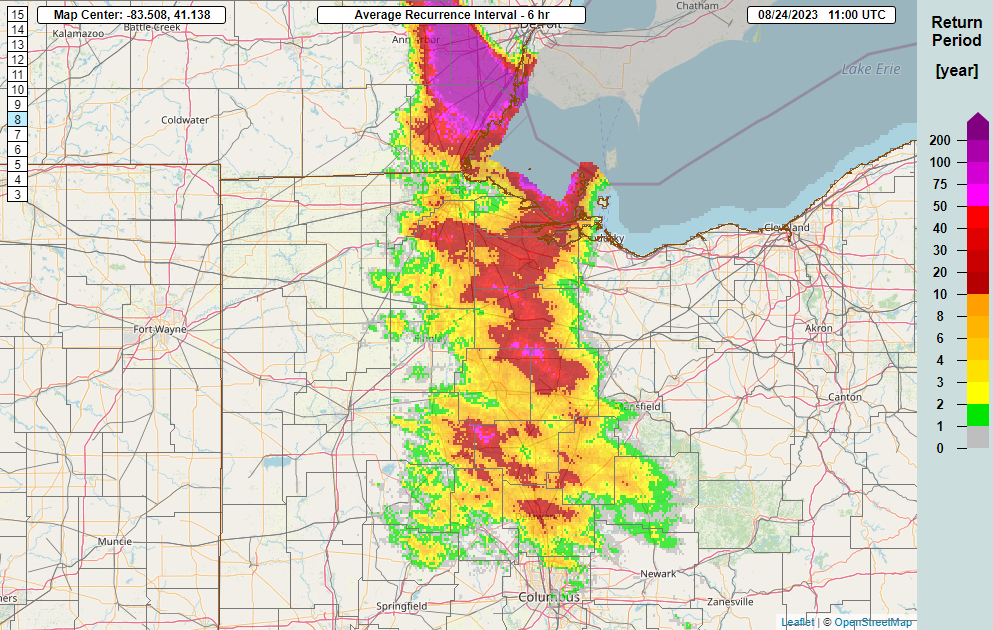
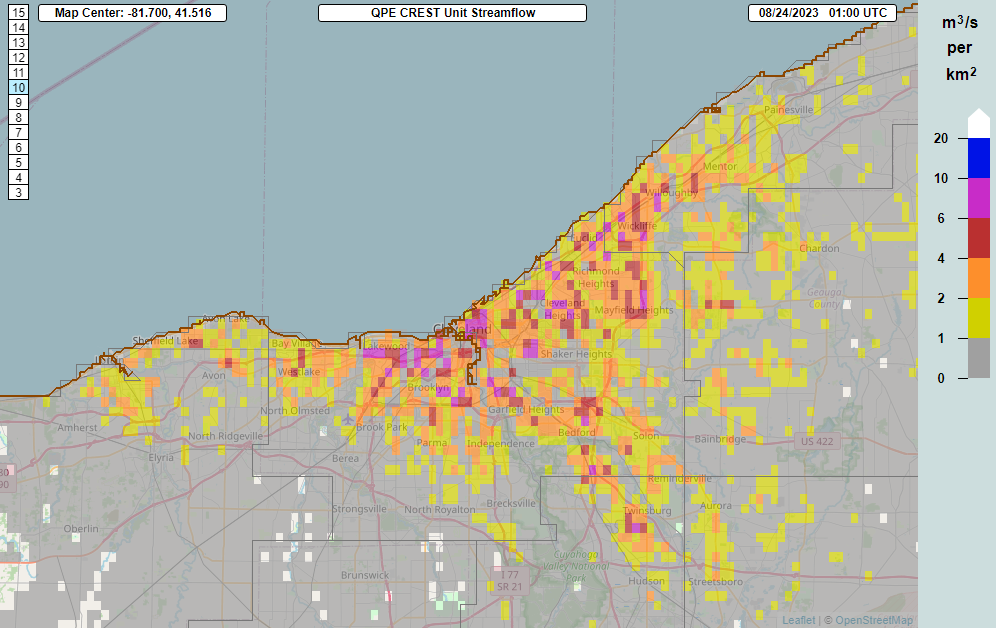
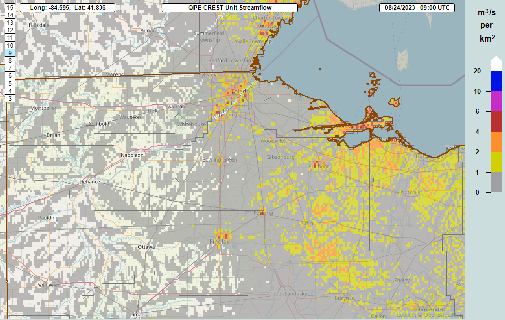
| MRMS estimated 6-hour rainfall average return interval from 10:00 PM Aug 23 - 4:00 AM Aug 24. The reds indicate an average 10-50 year return interval, with purples indicating 50-200+ years. Widespread flash flooding occurred in parts of Ottawa, Erie, Huron, Sandusky and Ashland Counties. | MRMS estimated 6-hour rainfall average return interval from 1:00 - 7:00 AM Aug 24. The reds indicate an average 10-50 year return interval, with purples indicating 50+ years. Flash flooding occurred in parts of several counties, including in the Toledo area. | MRMS CREST unit streamflow valid 9:00 PM August 23, showing excess run-off from heavy rainfall. Values of orange, red and purple indicate significant run-off amounts capable of producing potentially significant flash flooding as was observed in western Lake and Cuyahoga Counties. | MRMS CREST unit streamflow valid 11:30 PM August 23, showing excess run-off from heavy rainfall. Values of orange, red and purple indicate significant run-off amounts capable of producing potentially significant flash flooding as was observed in parts of Lorain and Ashland Counties. |
 |
 |
 |
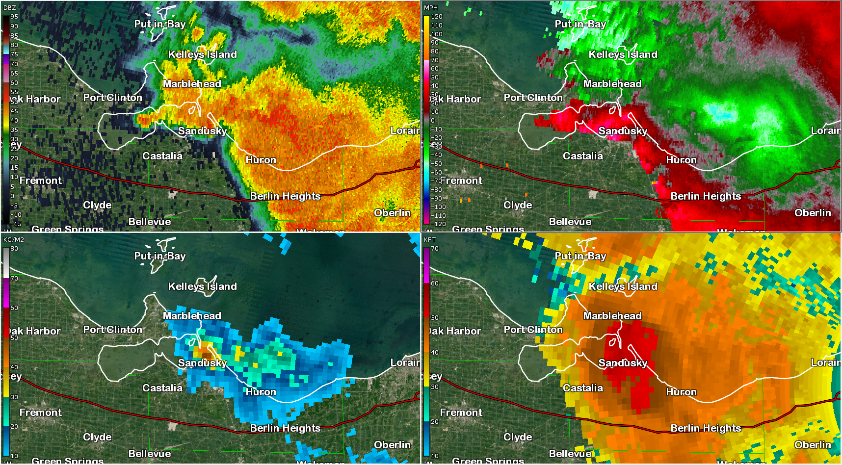 |
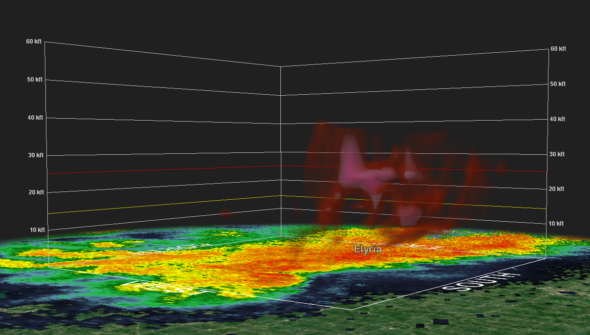
| MRMS CREST unit streamflow valid 2:00 AM August 24, showing excess run-off from heavy rainfall. Values of orange, red and purple indicate significant run-off amounts capable of producing potentially significant flash flooding as was observed near Port Clinton, Sandusky and Fremont. | MRMS CREST unit streamflow valid 4:00 AM August 24, showing excess run-off from heavy rainfall. Values of orange and red indicate significant run-off amounts capable of producing flash flooding as was observed in the Toledo area, where widespread street flooding stalled numerous vehicles. | 3D radar view of a large hail core (in whites) over Lorain County around 9 PM August 23rd. This hail core extended from about 10,000 feet to 35,000 feet aloft. Multiple reports of golf ball sized hail and damaging winds occurred as this hail core crashed to the ground. | 4-panel radar view showing reflectivity (upper left), velocity (upper right), VIL (bottom left) and echo tops (bottom right) of a severe storm that produced tree damage in the city of Sandusky. Note the diverging appearance on velocity, indicative of a downburst/microburst that can cause wind damage. Echo tops were approximately 55,000' high! |
Storm Reports

Link to Summary Local Storm Report
953
NWUS51 KCLE 291748
LSRCLE
Preliminary Local Storm Report
National Weather Service Cleveland OH
148 PM EDT Tue Aug 29 2023
..TIME... ...EVENT... ...CITY LOCATION... ...LAT.LON...
..DATE... ....MAG.... ..COUNTY LOCATION..ST.. ...SOURCE....
..REMARKS..
0140 PM Tstm Wnd Gst 2 NNW Sheffield Lake 41.51N 82.11W
08/23/2023 M35 MPH LEZ145 OH Buoy
Sheffield Buoy 45204 reported a wind gust of
35 knots.
0225 PM Tstm Wnd Dmg 2 SSW Medina 41.11N 81.88W
08/23/2023 Medina OH Public
Report from mPING: 1-inch tree limbs broken;
Shingles blown off.
0238 PM Tstm Wnd Dmg Creston 40.98N 81.90W
08/23/2023 Wayne OH Public
Report from mPING: 1-inch tree limbs broken;
Shingles blown off.
0238 PM Tstm Wnd Dmg 4 SSE Burbank 40.93N 81.96W
08/23/2023 Wayne OH Emergency Mngr
Steeple blown off church and several barn
roofs partially blown off.
0300 PM Tstm Wnd Gst 17 NE Marblehead 41.67N 82.45W
08/23/2023 M65 MPH LEZ164 OH Buoy
Buoy 45005 reported a wind gust of 56 knots.
0400 PM Tstm Wnd Gst 9 NW Marblehead 41.63N 82.84W
08/23/2023 M41 MPH Ottawa OH Mesonet
Mesonet station SBIO1 9 NE Port Clinton.
0435 PM Tstm Wnd Gst 2 SW Millersburg 40.53N 81.95W
08/23/2023 M40 MPH Holmes OH AWOS
AWOS station K10G 2 WSW Millersburg.
0608 PM Hail 1 NNW Hubbard 41.17N 80.58W
08/23/2023 E0.25 inch Trumbull OH Trained Spotter
0635 PM Tstm Wnd Gst 3 WNW Cleveland 41.50N 81.73W
08/23/2023 M44 MPH LEZ146 OH Mesonet
Mesonet station XCLE Cleveland - Edgewater.
0640 PM Tstm Wnd Gst 3 ENE Lakewood 41.50N 81.75W
08/23/2023 M43 MPH LEZ146 OH Mesonet
Mesonet station 45205 3 ENE Lakewood.
0745 PM Rain 4 SSE Painesville 41.68N 81.21W
08/23/2023 M1.70 inch Lake OH Public
1.70 inches measured in less than 2 hours
near Concord Township.
0745 PM Flash Flood 2 SW Painesville 41.71N 81.28W
08/23/2023 Lake OH Fire Dept/Rescue
Multiple roads flooded, some closed and
impassable due to high water.
0745 PM Rain 4 SSE Painesville 41.68N 81.21W
08/23/2023 M1.70 inch Lake OH Public
1.70 inches measured in less than 2 hours
near Concord Township.
0800 PM Tstm Wnd Gst 4 NNW Cleveland 41.53N 81.72W
08/23/2023 M40 MPH LEZ146 OH Buoy
Cleveland crib bouy measured a 35 knot wind
gust.
0815 PM Flash Flood 1 SW Wickliffe 41.60N 81.48W
08/23/2023 Lake OH Fire Dept/Rescue
Shoregate towers has significant structural
collapse. Fire official presuming this a
result of the water collection on the top of
their parking garage.
0820 PM Tstm Wnd Gst 2 NNW Sheffield Lake 41.51N 82.11W
08/23/2023 M45 MPH LEZ145 OH Mesonet
Mesonet station 45204 1 NW Sheffield Lake.
0830 PM Flash Flood 1 SW Willoughby 41.64N 81.42W
08/23/2023 Lake OH Fire Dept/Rescue
Vine Street viaduct at Ben Hur is flooded
with multiple vehicles stuck in the high
water.
0837 PM Tstm Wnd Gst 2 NW Brook Park 41.42N 81.85W
08/23/2023 M40 MPH Cuyahoga OH ASOS
ASOS station KCLE Cleveland.
0846 PM Hail 2 WSW Sheffield Lake 41.48N 82.13W
08/23/2023 E1.00 inch Lorain OH Public
Multiple reports received on social media of
at least quarter size hail between Lorain
and Sheffield Lake.
0848 PM Hail 1 NNE Lorain 41.45N 82.18W
08/23/2023 E1.00 inch Lorain OH Public
picture from social media of quarter size
hail.
0848 PM Tstm Wnd Dmg 1 NNW Lorain 41.45N 82.19W
08/23/2023 Lorain OH Amateur Radio
Telephone or power pole blown down in Lorian
near Orchard Hill and Cooper Foster.
0848 PM Tstm Wnd Gst 3 WNW Vermilion 41.43N 82.36W
08/23/2023 M56 MPH LEZ145 OH Mesonet
Mesonet station XVRM Vermilion.
0851 PM Flash Flood 1 NNW Willowick 41.64N 81.47W
08/23/2023 Lake OH Law Enforcement
The area of Lakeshore Blvd and Vine Street
is closed due to flash flooding.
0854 PM Hail 2 NW Elyria 41.39N 82.13W
08/23/2023 M1.75 inch Lorain OH Amateur Radio
Two minutes of hail ranging from quarter to
golf ball sized in Elyria Twp.
0854 PM Flash Flood 3 E Lakewood 41.48N 81.75W
08/23/2023 Cuyahoga OH Law Enforcement
Multiple roads becoming flooded and
impassable on the west of the Cleveland.
Multiple cars stranded. Closing the area of
Clifton Road and Lake Ave due to flash
flooding.
0859 PM Flash Flood 3 WNW Cleveland 41.49N 81.73W
08/23/2023 Cuyahoga OH Fire Dept/Rescue
Several cars stranded in flood waters on the
Shoreway blvd.
0900 PM Hail 1 NE Lorain 41.45N 82.17W
08/23/2023 E1.00 inch Lorain OH Trained Spotter
0900 PM Flash Flood 1 SSW Lakewood 41.47N 81.81W
08/23/2023 Cuyahoga OH Amateur Radio
Corrects previous flash flood report from 1
SSW Lakewood. 3 miles of I-90 is closed in
both direction near the McKinley Exit due to
considerable flooding and water rescues on
the interstate.
0900 PM Flash Flood 1 E Lakewood 41.48N 81.78W
08/23/2023 Cuyahoga OH Law Enforcement
Lakewood Police and Fire reporting multiple
homes with flooding of basements.
0900 PM Tstm Wnd Gst 3 E South Amherst 41.35N 82.18W
08/23/2023 M41 MPH Lorain OH ASOS
ASOS station KLPR Lorain Elyria.
0913 PM Flash Flood 2 E Lakewood 41.48N 81.76W
08/23/2023 Cuyahoga OH Amateur Radio
Multiple water rescues ongoing near Lakewood
reported by HAM Radio and Fire dept.
0915 PM Flash Flood 1 W Willoughby 41.65N 81.42W
08/23/2023 Lake OH Law Enforcement
Route 2 near Stevens Road is closed due to
flash flooding.
0918 PM Tstm Wnd Dmg 2 N Lorain 41.47N 82.18W
08/23/2023 Lorain OH Public
Numerous trees down across the city of Lorain.
0924 PM Tstm Wnd Dmg Wakeman 41.25N 82.40W
08/23/2023 Huron OH Emergency Mngr
Tree down and transformer on fire.
0928 PM Tstm Wnd Gst 2 SSE Kipton 41.24N 82.29W
08/23/2023 M55 MPH Lorain OH Mesonet
Mesonet station CW9769 Kipton.
0930 PM Flood 1 ESE Gates Mills 41.52N 81.39W
08/23/2023 Geauga OH 911 Call Center
County Line Rd closed at 322 due to
flooding. Time estimated.
0941 PM Hail 1 NE Wellington 41.17N 82.22W
08/23/2023 M1.75 inch Lorain OH Public
Golf ball size hail reported in Wellington,
OH.
0950 PM Tstm Wnd Gst 1 WNW Smithville 40.87N 81.88W
08/23/2023 M48 MPH Wayne OH ASOS
ASOS station KBJJ Wooster.
0956 PM Flash Flood 2 SW Bratenahl 41.54N 81.63W
08/23/2023 Cuyahoga OH Fire Dept/Rescue
CFD closed down portions of MLK near I-90
due to flooding.
0957 PM Flash Flood 2 SSW Linndale 41.42N 81.78W
08/23/2023 Cuyahoga OH Fire Dept/Rescue
Multiple underpasses along I-480 are flooded
and impassable.
1000 PM Flash Flood 3 SE Kirtland Hills 41.62N 81.28W
08/23/2023 Geauga OH 911 Call Center
East branch of Chagrin River out of banks
over Mitchells Mills Rd near Wisner. Time
estimated.
1012 PM Rain 1 W Lakewood 41.48N 81.83W
08/23/2023 M3.50 inch Cuyahoga OH Public
Many backyard rain gauges reporting 3 to 4
inches of rainfall in the last couple of
hours.
1020 PM Tstm Wnd Gst 6 NNW Marblehead 41.60N 82.78W
08/23/2023 M43 MPH LEZ143 OH Mesonet
Mesonet station 45201 5 NW Marblehead.
1020 PM Tstm Wnd Gst 3 WNW Vermilion 41.43N 82.36W
08/23/2023 M53 MPH LEZ145 OH C-Man Station
VRMO1 measured a 53 mph wind gust.
1020 PM Tstm Wnd Gst 3 WNW Vermilion 41.43N 82.36W
08/23/2023 M53 MPH LEZ145 OH Mesonet
Mesonet station VRMO1 2 WNW Vermilion.
1035 PM Tstm Wnd Gst 4 E Port Clinton 41.52N 82.87W
08/23/2023 M60 MPH Ottawa OH AWOS
AWOS station KPCW Port Clinton.
1040 PM Flash Flood 1 NNE Wellington 41.17N 82.22W
08/23/2023 Lorain OH Public
Report from mPING: Homes or buildings filled
with water.
1041 PM Tstm Wnd Dmg 2 SSE Sandusky 41.44N 82.70W
08/23/2023 Erie OH Emergency Mngr
Multiple large tree limbs blown down in
Sandusky.
1043 PM Tstm Wnd Gst 3 N Cleveland 41.52N 81.68W
08/23/2023 M44 MPH Cuyahoga OH ASOS
ASOS station KBKL Cleveland.
1043 PM Tstm Wnd Gst 18 NNW Vermilion 41.66N 82.42W
08/23/2023 M51 MPH LEZ164 OH Buoy
Buoy 45005 gusted to 51 mph.
1045 PM Tstm Wnd Gst 2 NE Fairview Lanes 41.44N 82.64W
08/23/2023 M53 MPH Erie OH Mesonet
Mesonet station AU939 Sandusky.
1049 PM Tstm Wnd Dmg 1 ESE Sandusky 41.45N 82.70W
08/23/2023 Erie OH Emergency Mngr
*** 2 INJ ***
Erie County EM reporting a large tree into a
house with injuries.
1050 PM Tstm Wnd Gst 2 N Port Clinton 41.53N 82.94W
08/23/2023 M47 MPH LEZ143 OH Mesonet
Mesonet station 45202 1 N Port Clinton.
1053 PM Hail 2 S Ashland 40.84N 82.31W
08/23/2023 E1.25 inch Ashland OH Public
1056 PM Tstm Wnd Gst 4 E Port Clinton 41.52N 82.87W
08/23/2023 M60 MPH Ottawa OH ASOS
Port Clinton ASOS measured a 60 mph wind
gust.
1056 PM Tstm Wnd Dmg 6 NE Port Clinton 41.56N 82.84W
08/23/2023 Ottawa OH Emergency Mngr
Ottawa County EMA reporting multiple large
trees blown down near Catawba and Port
Clinton.
1100 PM Tstm Wnd Gst 9 NW Marblehead 41.63N 82.84W
08/23/2023 M43 MPH Ottawa OH Mesonet
Mesonet station SBIO1 9 NE Port Clinton.
1100 PM Tstm Wnd Dmg 10 NW Marblehead 41.65N 82.83W
08/23/2023 Ottawa OH Amateur Radio
A couple trees were blown down on South Bass
Island.
1100 PM Tstm Wnd Gst 1 ENE Huron 41.40N 82.55W
08/23/2023 M49 MPH LEZ144 OH Mesonet
Mesonet station HHLO1 Huron.
1115 PM Tstm Wnd Gst 9 NW Marblehead 41.63N 82.84W
08/23/2023 M43 MPH Ottawa OH C-Man Station
South Bass SBIOL gusted to 43 mph.
1127 PM Tstm Wnd Dmg 3 E Bellevue 41.28N 82.79W
08/23/2023 Huron OH Public
Large tree down across road.
1143 PM Rain Mentor-on-the-Lake 41.71N 81.36W
08/23/2023 M3.65 inch Lake OH Public
Total rainfall for the day.
1154 PM Tstm Wnd Gst 2 SSW Green 40.92N 81.45W
08/23/2023 M41 MPH Summit OH ASOS
ASOS station KCAK Akron-Canton Regional
Arpt.
1154 PM Rain North Ridgeville 41.39N 82.02W
08/23/2023 M4.25 inch Lorain OH Public
Measured on personal weather station.
1200 AM Rain Elyria 41.37N 82.11W
08/24/2023 M3.99 inch Lorain OH Public
Measured on backyard weather station. Street
and basement flooding ongoing at time of
report.
1200 AM Tstm Wnd Gst 1 ENE Huron 41.40N 82.55W
08/24/2023 M40 MPH LEZ144 OH C-Man Station
HHLO1 measured a 40 mph wind gust.
1202 AM Tstm Wnd Dmg Norwalk 41.24N 82.61W
08/24/2023 Huron OH Emergency Mngr
*delayed report* An outbuilding sustained
significant damage on Dublin Rd, with much
of the roof blown into the nearby field.
1215 AM Tstm Wnd Gst Vickery 41.38N 82.94W
08/24/2023 E60 MPH Sandusky OH Public
1222 AM Flood South Bass Island 41.65N 82.83W
08/24/2023 Ottawa OH Trained Spotter
Flood waters 6 to 12 inches deep reported on
South Bass Island.
1230 AM Tstm Wnd Dmg Norwalk 41.24N 82.62W
08/24/2023 Huron OH Emergency Mngr
Tree downed onto a porch.
1231 AM Flash Flood Wellington 41.17N 82.23W
08/24/2023 Lorain OH NWS Employee
Flooding at the Lorain County fairgrounds
including several barns flooded and standing
water up to the bottom of parked cars.
1250 AM Tstm Wnd Gst 9 ENE Oregon 41.70N 83.26W
08/24/2023 M64 MPH LEZ142 OH Mesonet
Mesonet station TWCO1 8 ENE Oregon.
1251 AM Tstm Wnd Dmg 3 ESE Clay Center 41.56N 83.31W
08/24/2023 Ottawa OH Emergency Mngr
Tree and wires down in Martin Township.
0110 AM Tstm Wnd Gst 9 ENE Oregon 41.70N 83.26W
08/24/2023 M47 MPH LEZ142 OH Mesonet
Mesonet station 45165 8 ENE Oregon.
0150 AM Tstm Wnd Gst 2 SW Findlay 41.02N 83.67W
08/24/2023 M49 MPH Hancock OH ASOS
ASOS station KFDY Findlay.
0155 AM Tstm Wnd Dmg 2 W Findlay 41.04N 83.69W
08/24/2023 Hancock OH 911 Call Center
Power pole downed.
0200 AM Tstm Wnd Dmg Jenera 40.90N 83.73W
08/24/2023 Hancock OH 911 Call Center
Power pole downed.
0210 AM Tstm Wnd Gst 18 NNW Vermilion 41.67N 82.40W
08/24/2023 E51 MPH LEZ164 OH Buoy
Buoy 45005 measured a 51 mph wind gust.
0215 AM Flash Flood 5 WNW Marblehead 41.55N 82.81W
08/24/2023 Ottawa OH Trained Spotter
Water rescue at the time of the report at a
campground on Catawba Island.
0221 AM Flood Port Clinton 41.51N 82.94W
08/24/2023 Ottawa OH Trained Spotter
Perry Street flooded in Port Clinton.
0338 AM Rain 3 W Marblehead 41.53N 82.78W
08/24/2023 M7.34 inch Ottawa OH Public
Measured on Davis weather station.
0406 AM Tstm Wnd Gst 1 NNW Fairport Harbor 41.76N 81.28W
08/24/2023 M39 MPH Lake OH Buoy
Buoy station FAIO1 Fairport, OH.
0413 AM Rain New London 41.08N 82.40W
08/24/2023 M4.24 inch Huron OH Public
Measured via personal weather station.
0442 AM Flood 3 SSW Green 40.90N 81.47W
08/24/2023 Stark OH Broadcast Media
State route 241 closed at Shuffel St due to
flooding in North Canton.
0533 AM Flash Flood Toledo 41.66N 83.58W
08/24/2023 Lucas OH Broadcast Media
Widespread street flooding in Toledo with
numerous stalled vehicles.
0541 AM Flood Huron 41.39N 82.56W
08/24/2023 Erie OH Public
Huron City Schools closed due to flooding in
buildings and around the community.
0542 AM Rain 3 NW Harbor View 41.72N 83.49W
08/24/2023 M2.31 inch Lucas OH Trained Spotter
Rainfall since 3:30am.
0557 AM Flood 3 NNE Rochester 41.17N 82.29W
08/24/2023 Lorain OH Dept of Highways
State Route 18 closed in multiple locations
due to flooding.
0557 AM Flood 4 SE Kipton 41.24N 82.25W
08/24/2023 Lorain OH Dept of Highways
State Route 303 closed due to flooding
between Quarry Rd and Pitts Rd.
0800 AM Rain Euclid 41.59N 81.53W
08/24/2023 M3.10 inch Cuyahoga OH Trained Spotter
Rainfall since noon 8/23.
0941 AM Rain 1 ESE Sandusky 41.45N 82.69W
08/24/2023 M5.53 inch Erie OH Trained Spotter
24 hour rainfall.
1218 PM Rain 2 S Pemberville 41.39N 83.46W
08/24/2023 M3.73 inch Wood OH NWS Employee
24 hour rainfall.
0250 PM Tstm Wnd Gst 4 NNW Bratenahl 41.62N 81.62W
08/24/2023 M43 MPH LEZ146 OH Mesonet
Mesonet station 45197 4 NNW Bratenahl.
0301 PM Tstm Wnd Dmg 3 SSE Parma 41.35N 81.72W
08/24/2023 Cuyahoga OH Fire Dept/Rescue
North Royalton FD reported several tree
blown down and power lines blown down
between W Sprague Road and Bunker Road just
east of State Road 94.
0308 PM Tstm Wnd Dmg 2 S Parma 41.35N 81.72W
08/24/2023 Cuyahoga OH Trained Spotter
Numerous trees down near State Rd and
Sprague Rd.
&&
$$
Environment
 |
 |
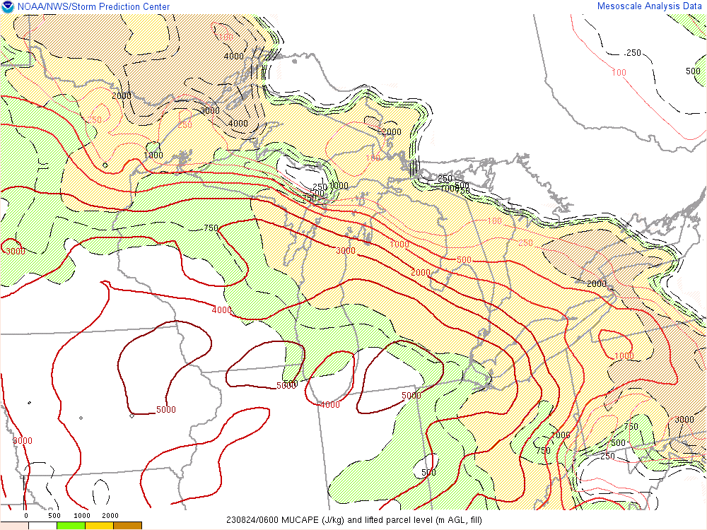 |
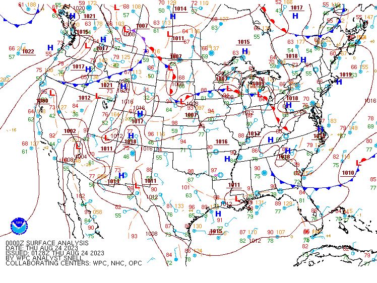
| Figure 1: WPC surface analysis at 8 PM on August 23, 2023. Note the presence of a warm front oriented roughly northwest to southeast across the Lower Great Lakes region. | Figure 2: Precipitable water values at 2 AM on August 24, 2023. Note PWAT values exceeding 2.0 inches across SE MI and NW OH. | Figure 3: Most unstable CAPE values at 2 AM on August 24, 2023. Note the extreme instability present across NW OH of 4500 to 5000 J/kg. |
 |
 |
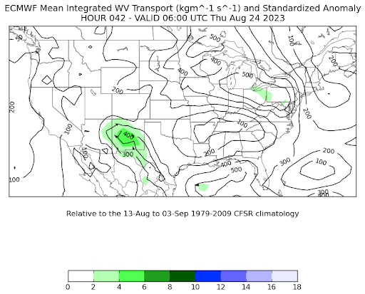 |
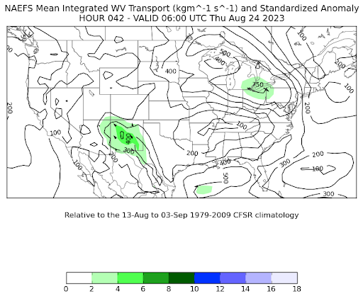
| Figure 4: Low-level (925 to 850 mb) moisture transport vectors at 2 AM. Note the ample moisture being transported eastward across the Lower Great Lakes region, feeding the multiple rounds of convection. | Figure 5: NAEFS integrated water vapor transport (VIT) standard anomalies 42 hours leading up to the event. Note a localized area of 2 standard deviations across SE MI and northern OH. | Figure 6: ECMWF ensemble IVT standard anomalies 42 hours leading up to the event. Note the localized area of 2 standard deviations across SE MI and northern OH, though slightly less apparent versus the NAEFS. |
 |
Media use of NWS Web News Stories is encouraged! Please acknowledge the NWS as the source of any news information accessed from this site. |
|

