** Full report of the State Climate Extremes Committee**
Public Information Statement
National Weather Service Cleveland OH
1122 AM EDT Wed Aug 22 2018
...Snowfall Values Changed at Erie International Airport for 2017- 2018 Winter Season...
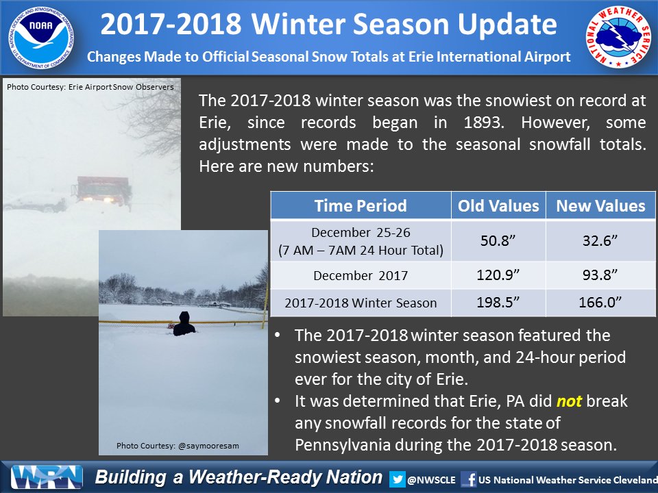
During the week of December 24, 2017, an intense lake effect snow event impacted northwestern Pennsylvania, bringing several feet of snow to Erie, Pennsylvania and surrounding areas. The most severe portion of this event occurred on December 25-26 when over 50 inches of snow was reported over a 24-hour period on the Christmas holiday at Erie International Airport, a primary National Weather Service climate site. This garnered local, regional, and national media attention due to the amount of snow that fell in a short period of time. In addition, the snowfall totals also gained attention from the meteorological community due to the initial snow totals exceeding 24-hour and monthly records for the state of Pennsylvania.
With the original snow measurements at Erie International Airport exceeding the recognized state records for 24-hour and monthly snowfall, an official State Climate Extremes Committee, or SCEC, was formed per NWS Directive NWSI 10-1004. This SCEC met several times to review the original data from Erie airport and discuss the validity of the potential snowfall records as committee members included staff from the following entities: NWS Cleveland, NWS Eastern Region Headquarters, NOAA`s National Centers for Environmental Information (NCEI), Pennsylvania State Climate Office at Penn State University, and Northeast Regional Climate Center (NRCC) at Cornell University.
The committee reviewed the meteorology of the December 24-26 snow event to show the plausibility of record-breaking snowfall during the time period in question. The committee reviewed the observing practices of the snow observers at Erie International Airport to ensure that they followed NWS Snow Measurement Guidelines including: equipment used and siting, observing times, and observer methodology. The committee also compared the numbers at Erie International Airport to surrounding snow observing sites including NWS Cleveland snow spotters and CoCoRaHS observers.
After extensive data review and deliberation, the committee has determined that the original 24-hour and monthly snow totals from Erie Airport are invalid and will not hold as state records. The main reason that the original values are invalided are because there was a large discrepancy between new snowfall and snow depth among several dates, including the 24-hour maximum. During that time, 50.8 inches of snow reportedly fell but only a maximum snow depth of 28 inches was reported. It was also discovered in interviewing the snow observers that the snow measurement board was not always placed on top of the snowpack after a measurement was made, although there was higher snow around the board, allowing for a cratering effect. The snow observers for Erie Airport were new for the 2017-2018 winter season and began measuring snow for NWS Cleveland on December 7, 2017. While NWS Cleveland provided training, an extraordinary snow event, with an extreme amount of snow and significant wind causing blowing and drifting, is difficult for even the most experienced observer, let alone for new observers just weeks into their observing tenure.
Once this data was invalidated, a new committee was formed to address what snowfall totals would be used for December 2017. After more meetings and discussion, it was determined that observations from a nearby NWS Cleveland snow spotter with many years of experience would be utilized for the entirety of December 2017. In addition, a few adjustments were made to snowfall amounts in March 2018. (A separate report on this committee`s discussion and methodology will be released at a later time.)
We are thereby today announcing the new snow totals for Erie airport for the late December snow event, the month of December, and the new seasonal total.
24-Hour Snowfall from 7 AM December 25 to 7 AM December 26:
Original Values: 50.8 inches of snow
Revised Values: 32.6 inches of snow
Monthly Snowfall from December 2017:
Original Values: 120.9 inches of snow
Revised Values: 93.8 inches of snow
Seasonal Snowfall from the 2017-2018 Winter Season:
Original Values: 198.5 inches of snow
Revised Values: 166.3 inches of snow
These numbers have been reviewed and will be certified by NOAA`s National Centers for Environmental Information (NCEI) now that the SCEC report and recommendations have been released. This information will become available in official NCEI datasets in the coming weeks.
The revised values are new 24-hour, monthly, and seasonal records for the city of Erie. Here are the old record values that were broken after the previous winter season:
Old 24-Hour Record: 20.0 inches of snow, set on November 22, 1956
Old Monthly Record: 66.9 inches of snow, set in December 1989
Old Seasonal Record: 149.1 inches of snow, set during the 2000-2001 winter season
The revised values are not new 24-hour, monthly, and seasonal records for the state of Pennsylvania. Here are the standing record values that remain for the state of Pennsylvania:
Standing 24-Hour Record: 38.0 inches of snow, set on March 20, 1958 in Morgantown, PA
Standing Monthly Record: 117.8 inches of snow, set in February 2010 in Laurel Summit, PA
Standing Seasonal Record: 218.3 inches of snow, set during the 2009- 2010 winter season in Laurel Summit, PA
For any additional information or media inquiries, please contact Susan Buchanan, National Weather Service Director of Public Affairs, at (301)-427-9000.
$$
NWS Cleveland

