Let's start with the wall of shame:
“This was initially called in as a structure fire, due to the fire being very close to a shed near the residence. Upon arrival Casper Fire/EMS, Mills Fire Department, and Natrona County Fire District noticed that the fire started at the base up the hill and traveled up the hill with the high winds.” - Fire crews responded to a brush fire along Wolf Creek Road this afternoon OilCityWyo.com April 14, 2015
"Fortunately, the irrigation district had a water truck on hand and the Riverton Fire District sent three units to the scene to control the fire, which creeped into a stand of old willows next to the irrigation canal and on to Pierson’s property."Fire destroys abandoned chicken coop as canal banks were being burned, County10.com May04, 2015
"Initially fire fighters were called for a report of a grass fire but that was quickly upgraded to a structure fire. Radio traffic at one point indicated that a controlled trash burn might have gotten out of control." Single Family Home Lost in Fire this Afternoon Near Kinnear, County10.com May 01, 2014
"It started with a little burn pile, not more than four feet across, but then the wind came up. An ember flew into adjoining sagebrush and a new fire started, which consumed about an acre of land and several trees and threatened several homes." - Grass Fire Sent Riverton firefighters on WRIR Sunday Afternoon, Buckrail.com March 23, 2014
Fire danger increases rapidly in the spring once the snow beings to melt, especially in windy lower elevation spots like Cody, Dubois, Buffalo, Riverton, and Casper. These conditions often result in several agricultural burns getting out of control year after year. The National Weather Service in Riverton is advising people to get the most up-to-date weather forecast before conducting agricultural burns - Learn Before You Burn!
 |
|
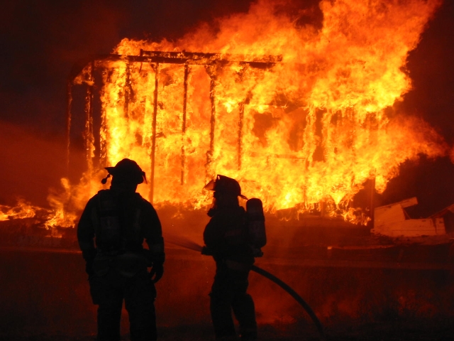
Click Image To Enlarge Don't let this happen to you! The Little Horsethief Fire was started inadvertently when a fire in this barrel was left unattended! This mistake cost him $3 Million. Photo: jhnewsandguide.com |
It doesn’t take long once the snow begins to melt for fire danger to rapidly increase even after a cool and wet winter. The persistent spring wind only serves to further dry vegetation and literally provides more fuel for the fire. A wind-whipped fire in quick-burning dormant vegetation can cause a burn to easily become uncontrollable.
It is common for calm morning wind to give way to gusty wind around the midday hours during the spring months. A weather forecast of how and when the wind speed and direction may change during the day can mean the difference between a successful burn and having an animated discussion with your local fire warden.
Federal and state land management agencies routinely obtain weather forecasts from the National Weather Service. So should you! In fact, landowners, conservation districts -- even local fire officials -- should get the most up-to-date forecast possible before lighting a controlled burn. Your local National Weather Service office can be contacted 24 hours a day by phone. The two NWS offices located in Wyoming are in Cheyenne (1-800-269-6220) and Riverton (1-800-211-1448) and are staffed 24 hours a day. Area-specific forecasts are also available online (weather.gov/cheyenne and weather.gov/riverton) or on your SmartPhone at mobile.weather.gov.
What if your agricultural burn becomes out-of-control and causes property damage? You can imagine damage costs and firefighting costs can quickly escalate when homes are lost, outbuildings torched, and fences damaged. After a large fire in 2013, the U.S. Forest Service billed a Jackson man $3 million for the costs of fighting a wildfire he is accused of starting when he burned twigs and paper in a barrel. Yikes! It might have been cheaper to take it to the dump!
Landowners, conservation districts, and others who plan to conduct prescribed burning activities are strongly encouraged to check the latest weather forecast by calling the National Weather Service in Cheyenne toll-free at 1-800-269-6220. They should inform local government officials of burn plans as well.

 |
| Don't let your property become a statistic! |
Agricultural burning is the practice of using fire to reduce or dispose of vegetative debris from an agricultural activity. Some common practices include:
field burning large areas of crop residue after harvest to reduce excess plant material, to control crop diseases, weeds or pests, or to maintain crop yields
disposing of piles of agricultural debris, such as orchard trees, limbs, or haystacks
clearing vegetation out of irrigation ditches and canals
It is clear that agricultural burning has been used for years to perform vital functions, but it can be risky. Here are some tips on how to reduce that risk:
|
1.Call the National Weather Service in Cheyenne any time of the day or night at 1-800-269-6220. The weather can play a pivotal role in whether your burn is successful or not. Light winds in the morning can become strong in the afternoon at the blink of an eye. We can tell you if that is likely to happen on the day you would like to burn and we can help you find a safer day if necessary |
|
2.Contact Local Authorities. By calling the authorities first you ensure that your burn is legal and that it is not taxing resources unnecessarily. The local sheriff and your local fire department do not want to field calls about your burn and have them turn into a false alarm. In addition, you may have to obtain a burning permit. |
|
3.Talk to Your Neighbors. Let them know your plans, as a matter of safety and courtesy. |
|
4.Establish Firebreaks. Create firebreaks by raking or plowing around the area that |
|
5.Ready Water and Equipment. Have a reliable water source available. Line up your hand tools such as rakes and shovels in advance and have them readily available for all participants. |
|
6.Plan Before Burning.
|
|
Control the Fire!
|
|
Remember: Your fire is your responsibility! |

 |
Monitor our Severe Weather Summary Page for current Fire Weather Warnings, Watches, and Advisories. What's the difference? |
 |
Want an hour by hour forecast for your specific location? Try our Activity Planner tool to query our forecasts for certain parameters of interest (e.g. Wind Gusts over 25 mph) or you can see all forecast parameters on a graph for the next 48 hours by selecting the "48 Hour Element Meteorogram" below your Activity Planner forecast. |
|
Submit storm reports/images and keep up to date with us on Facebook! Follow us on Twitter for a play-by-play of the weather, search #LearnB4UBurn for the latest on the Spring Burning Campaign. |


 you would like to burn. Keep that area free of vegetation and wide enough to protect what you don't want damaged outside the burn area.
 Weather Story
 Local Radar
 Weather Map
 Follow us on YouTube
  Local Radar
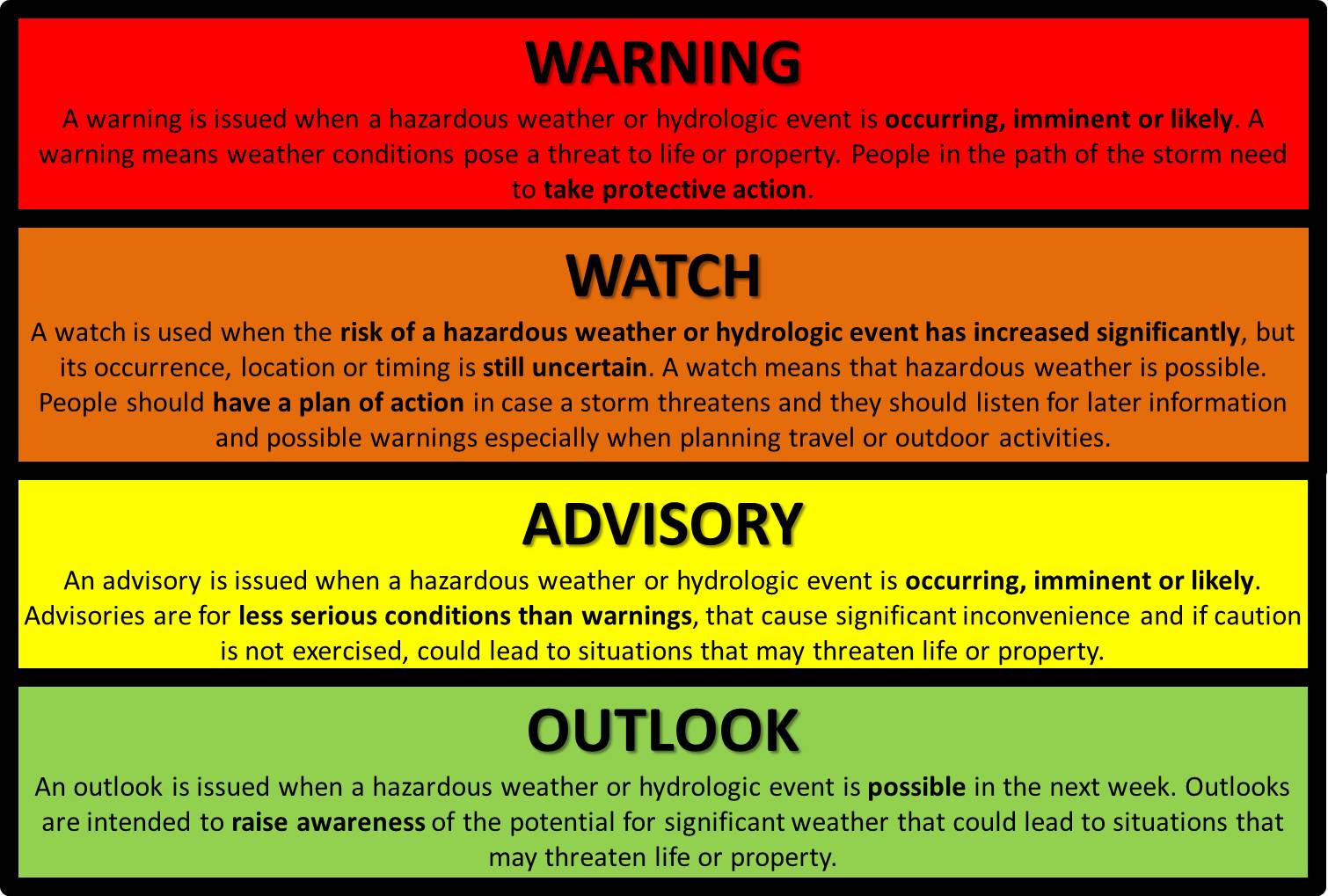