Widespread, life-threatening considerable flash flooding is expected in south-central Texas through at least Friday. Catastrophic river flooding and rapid rises on small streams, arroyos, and typically dry washes are expected in the Texas Hill Country. Wildfire smoke is impacting air quality across much of the Great Lakes region into the Northeast U.S. with Air Quality Alerts in effect. Read More >
Blizzard Summary and Impacts across Southwest Kansas
by Jesse Lee
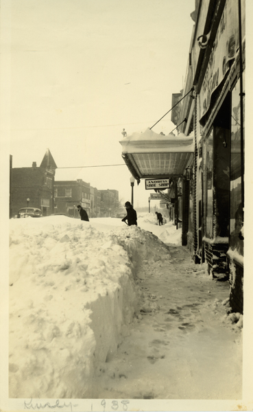
Thursday is the 84th anniversary of the April 7-8, 1938 blizzard. The blizzard began at Dodge City on Thursday morning, April 7th, with north winds blowing at 30 to 35 mph. Snowfall rates of around 7 tenths of an inch an hour began around 11 am that morning and continued until midnight. The total snowfall for the day was 10.6 inches. Temperatures were between 20 and 25 degrees. The snow and blowing snow restricted visibilities to near zero. Early in the evening, streets and roads were blocked and by late evening and overnight they were completely blocked. Railroads were also blocked during the night and Dodge City was shut off from the outside world. Many telegraph and telephone lines were down. There were a great number of automobiles, trucks, etc., that stalled in snow drifts. The blizzard ended before sunrise the next morning, however the strong north winds and blowing snow continued to restrict visibilities during the early part of the day. All roads, streets and railroads were blocked during the morning. There were drifts of eight to ten feet high with a few places having even higher drifts. The snow began to melt and settled during the afternoon as the temperature rose to a high of 38 degrees under a sunny sky. The wind had gradually settled down to around 15 mph by mid-evening Friday. Most roads and streets were still impassable Saturday morning. The snow melted rapidly during the day with temperatures rising into the upper 40s and by that evening traffic was resumed in most parts of town. Snow plows and crews had opened county roads on the main highways. By Sunday the traffic was back to normal in Dodge City. The total snowfall from the storm was 14.3 inches. This was the worst April blizzard on record for Dodge City. Prior to this storm, the highest snowfall for April had been 7.6 inches back on April 8-9, 1919. The next highest is 10 inches in April 13-14, 2007.
|
|
|
Snowfall totals and storm track
by Jonathan Finch & Mike Umscheid
On April 5th into the 6th, heavy snow was confined to areas farther north including northeastern Colorado and much of western and northern Nebraska. Snowfall totals in this region were in the 6 to 10 inch range with some locally higher amounts. As the low developed on the 7th, heavy snow and blizzard conditions overspread much of southwestern Kansas and into much of western and central Oklahoma. Portions of northwest Texas were even included in the heavy snowfall, which is extremely rare for the time of year!
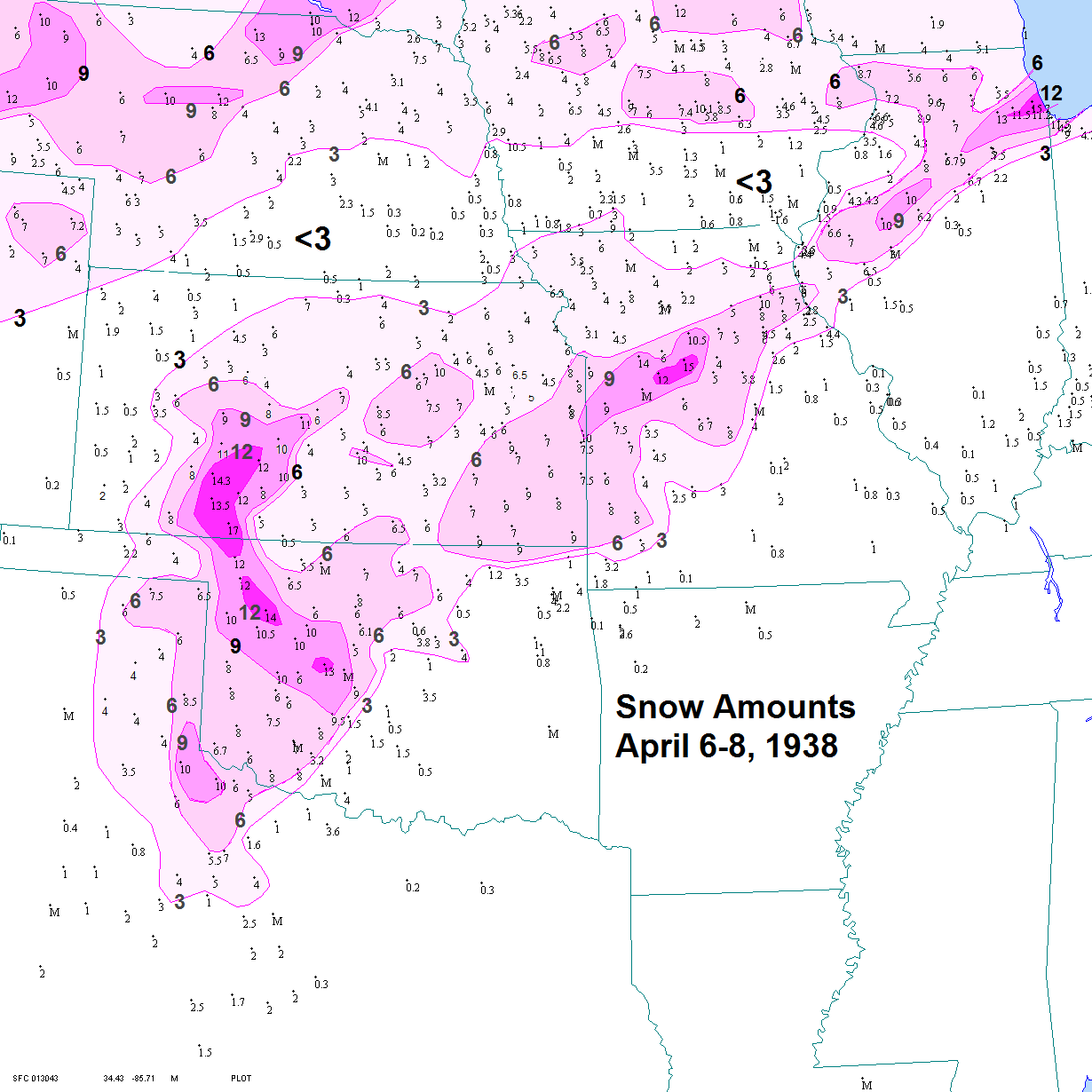
(click on the figures above for higher resolution)
This blizzard serves as a good example of how snowfall can vary tremendously from location to location
by Jonathan Finch
The blizzard of April 7-8, 1938 illustrates how snowfall can vary tremendously from location to location. Bands of heavy snow are often only 20 or 30 miles wide and only 3 or 4 miles wide in extreme cases. Snow amounts can vary from one county to the next and even across one county. In the April 1938 case, 17” of snow fell at Ashland, but only 5” fell 25 miles to the east at Coldwater. Only 4” fell at Beaver, about 45 miles to the southwest of Ashland. This is why we give ranges of snowfall, like 4 to 8”, 2 to 4” or 6 to 10”. Sometimes even these ranges are not large enough. For example, you could receive 4” of snow at your house and someone just a few miles away could measure 10”.
The paths of upper level storm systems that cause snow are not known with high accuracy several days ahead of time. If a 5-day forecast of an upper level storm system currently 5,000 miles to the west (over the Pacific Ocean) is off by 100 miles, then a heavy snow band could completely miss southwest Kansas and produce heavy snow across the Oklahoma panhandle or in northwest Kansas. The strength of the systems has a huge impact on snow amounts as well. For example, a slower moving system with a closed off circulation would produce more snow than a fast moving one.
Precipitation type can be hard to forecast as well. For example, when making a 3 day forecast for a possible snow event, if a cold air mass two thousand miles away over western Canada arrives a few hours late into western Kansas, then much of a precipitation event could be rain or sleet instead of snow. Another complicating factor is the geographic location of southwest Kansas. Due to the presence of the Rocky Mountains, synoptic scale cyclones and precipitation shields often develop initially over the high plains instead of moving in from the mountains. As a result, storm systems sometimes are dry until they reach southwestern Kansas. Therefore, precipitation shields often organize right over the high plains region and cannot be tracked into our area. In addition to all of these complicating factors, snow is typically very hard to measure in western Kansas due to strong winds and resultant drifting. Therefore, you could measure 6” at your house but your next door neighbor could estimate 10” from the same storm.
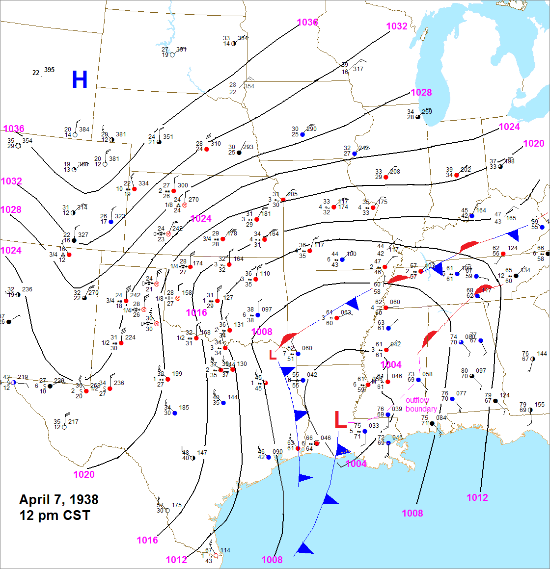
Surface analysis at 12:00pm on April 7th, during the height of the blizzard across the western plains.
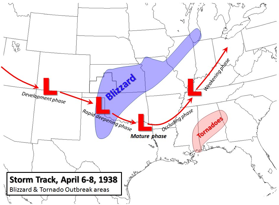
A severe weather outbreak was unfolding across the Gulf Coast region from eastern Louisiana into Mississippi and Alabama.
Meteorological Charts using 20th Century Reanalysis Dataset
by Mike Umscheid
The 20th Century Reanalysis dataset was analyzed for the dates April 4 through April 8, 1938, using Unidata's Integrated Data Viewer display software. The figures that follow are upper air and surface output from the reanalysis model. In the left pane, 500mb Geopotential Height and 700mb Relative Humidity are overlaid to provide a visualization of the principle low track and and evolution day-to-day from April 4th through 8th. On the right pane, 850mb Temperature and Mean Sea-level Pressure are overlaid to show the surface low and high centers along with the tight pressure gradient in between, yielding the very strong winds to promote blizzard conditions. The -2°C isotherm at 850mb is indicated at each analysis time to suggest where the rain-snow was most likely positioned at the time.
(click on the figures below for a higher resolution version)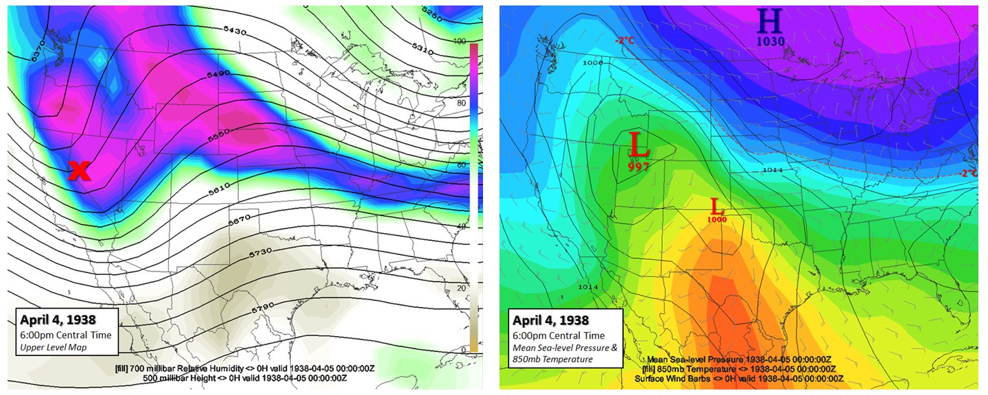
The evening of April 4th: The first wave develops and digs across the western United States. Warm air was lifting north through the southern plains. A very cold air source was positioned just to the north across the northern plains and midwest region. Snow was beginning to develop in the cold sector with the initial wave across the northern Rockies and adjacent northern High Plains region. The high temperature in Dodge City on the 4th was 69°F
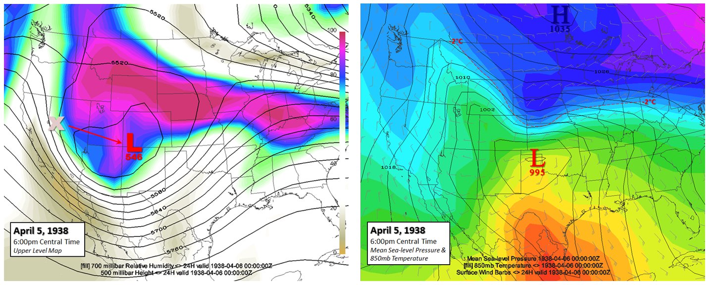
The evening of April 5th: The first weak wave lifted north into western Nebraska on the 5th, but the much more significant jet streak was beginning to carve out another more significant low over the four corners region. Snow was becoming more widespread across Wyoming and western Nebraska...spreading into central Nebraska late in the day. By late in the day, the cold front was making its push southward into southwestern Nebraska. The high temperature on the 5th in Dodge City was 69°F for the second day in a row.
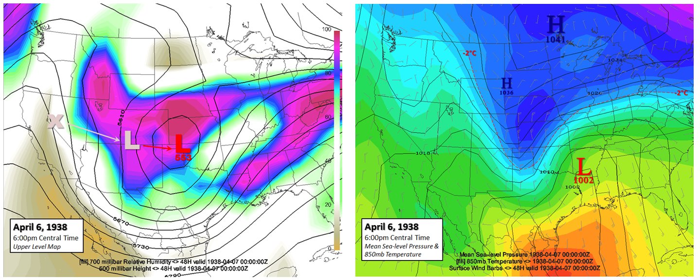
The evening of April 6th: The primary upper low was beginning to develop across the Texas Panhandle into northwestern oklahoma. Snow was occurring much of the day across Nebraska and northwestern Kansas, mainly tied to the first upper air disturbance. This first wave was weakening as the main upper low was developing by the night of the 6th. The cold front was plunging rapidly south through western Kansas into the Texas Panhandle during the day on the 6th. The front passed through Dodge City, KS during the overnight hours on April 5th and a light freezing drizzle was observed for much of the day with glaze on exposed surfaces by afternoon with a temperature around 30°F
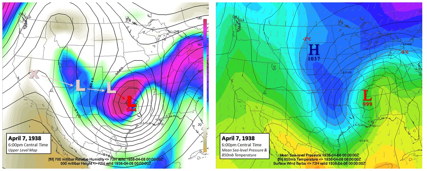
The evening of April 7th: The upper low underwent major cyclogenesis on the 7th as it tracked from the Texas Panhandle east southeast across southern Oklahoma. The 500mb height at the center of the low dropped from around 553 decameters to 544 decameters in the 24-hr time frame between the two reanalysis valid times. The brunt of the storm occurred during the afternoon and nighttime hours. The 1037mb high, per reanalysis, to the north across the Black Hills region and the 999mb low near Memphis, TN led to widespread sustained winds in the 30 to 40 mph range across much of southwestern Kansas and western Oklahoma. The high temperature on the 7th at Dodge City was only 25°F!
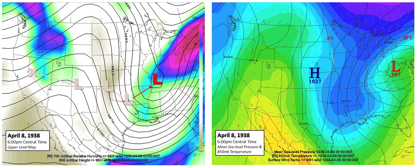
The evening of April 8th: The cyclone was underging a significant occlusion phase and eventual weakening on the 8th as the storm pulled away from the southern plains. Snow ended in Dodge City just prior to sunrise, but strong winds continued to promote light blowing snow through the morning hours.
Story Authors:
Jesse Lee
Jonathan Finch
Mike Umscheid
National Weather Service Dodge City
Acknowledgements
20th Century Reanalysis V2 data provided by the NOAA/OAR/ESRL PSD, Boulder, Colorado, USA, from their Web site at http://www.esrl.noaa.gov/psd/
Support for the Twentieth Century Reanalysis Project dataset is provided by the U.S. Department of Energy, Office of Science Innovative and Novel Computational Impact on Theory and Experiment (DOE INCITE) program, and Office of Biological and Environmental Research (BER), and by the National Oceanic and Atmospheric Administration Climate Program Office
Mapping of Reanalysis data produced using Unidata Integrated Data Viewer, which can be downloaded from their website at http://www.unidata.ucar.edu/software/idv/
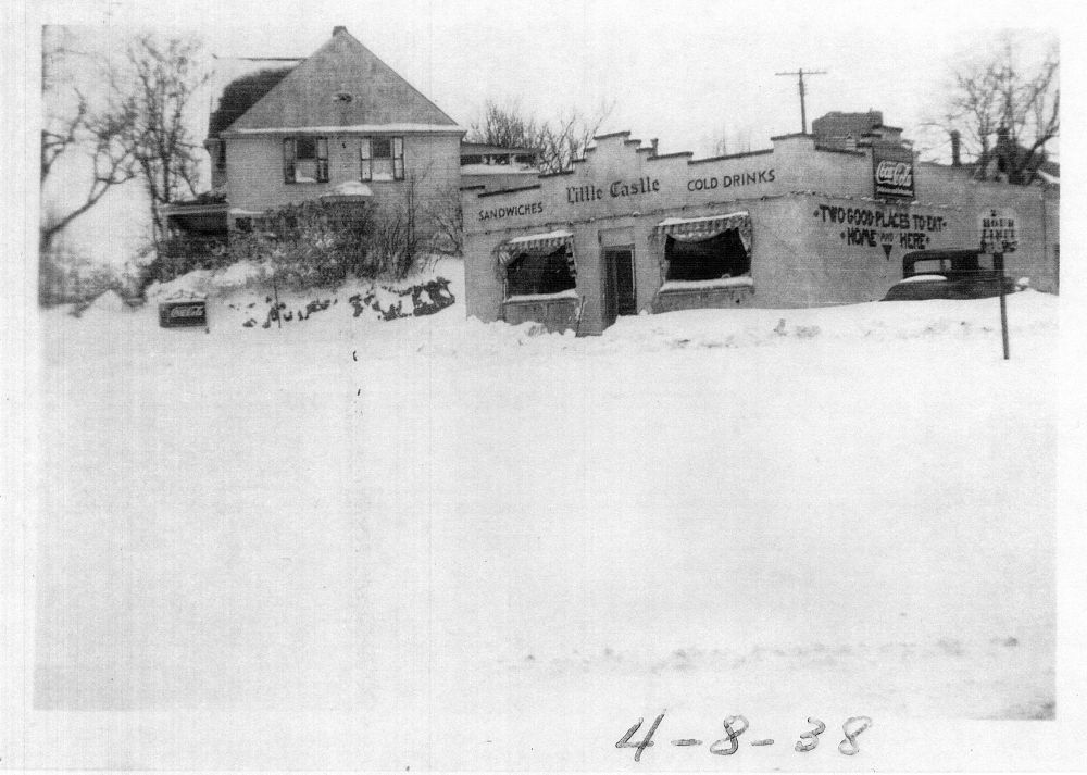
Thanks to both the Kansas Heritage Center in Dodge City and the Kinsley Library for the historical photos used in this story.